
SEISMOLOGY AND GEOLOGY ›› 2026, Vol. 48 ›› Issue (4): 1068-1092.DOI: 10.3969/j.issn.0253-4967.20260024
• Research paper • Previous Articles Next Articles
GEOLOGICAL TECTONICS AND CONSTRUCTION OF A HIGH-PRECISION EARTHQUAKE CATALOG AROUND HAINAN ISLAND BY USING MACHINE LEARNING
LI Yun-hui1,2)( ), LEI Jian-she2),*(), GUAN Hui-min3), HU Xiao-hui2), HAO Jiang-bo1)
- 1)
Shanxi Datong University
2)National Institute of Natural Hazards ,Ministry of Emergency Management of China
3)China University of Geosciences(Beijing)
-
Received:2026-02-27Revised:2026-04-09Online:2026-08-20Published:2026-09-09
利用机器学习构建海南岛及邻区高精度地震目录与地质构造
李云辉1,2)(), 雷建设2),*(), 关慧敏3), 胡晓辉2), 郝江波1)
- 1)
山西大同大学
2)应急管理部国家自然灾害防治研究院
3)中国地质大学(北京)
-
通讯作者:* 雷建设, 男, 1969年生, 博士, 研究员, 主要从事地震波层析成像理论与应用研究, E-mail: jshlei_cj@126.com。 -
作者简介:李云辉, 男, 1997年生, 现为山西大同大学资源与环境专业在读硕士研究生, 主要从事微震检测研究, E-mail: 1073902035@qq.com。
-
基金资助:国家自然科学基金(42230306)

Cite this article
LI Yun-hui, LEI Jian-she, GUAN Hui-min, HU Xiao-hui, HAO Jiang-bo. GEOLOGICAL TECTONICS AND CONSTRUCTION OF A HIGH-PRECISION EARTHQUAKE CATALOG AROUND HAINAN ISLAND BY USING MACHINE LEARNING[J]. SEISMOLOGY AND GEOLOGY, 2026, 48(4): 1068-1092.
李云辉, 雷建设, 关慧敏, 胡晓辉, 郝江波. 利用机器学习构建海南岛及邻区高精度地震目录与地质构造[J]. 地震地质, 2026, 48(4): 1068-1092.
share this article
Add to citation manager EndNote|Ris|BibTeX
URL: https://www.dzdz.ac.cn/EN/10.3969/j.issn.0253-4967.20260024
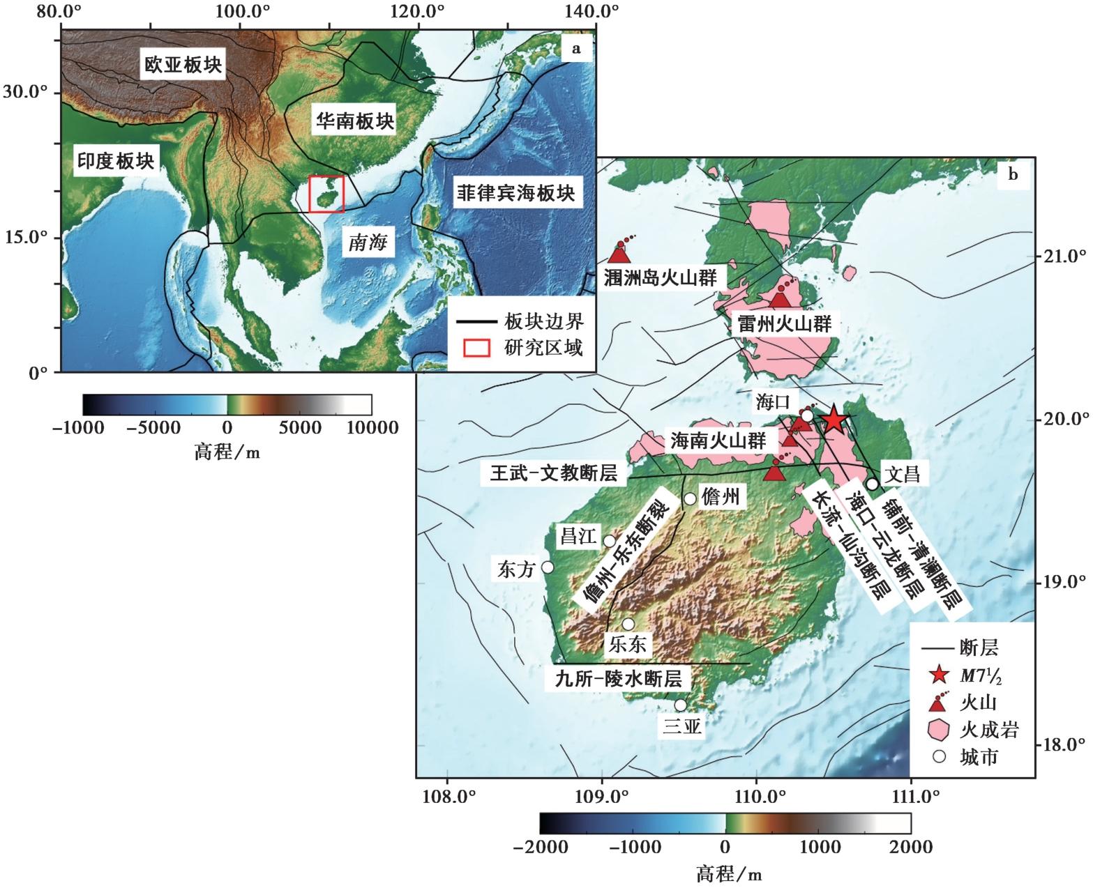
Fig. 1 Regional tectonic settings and distribution of main faults in and around Hainan Island.
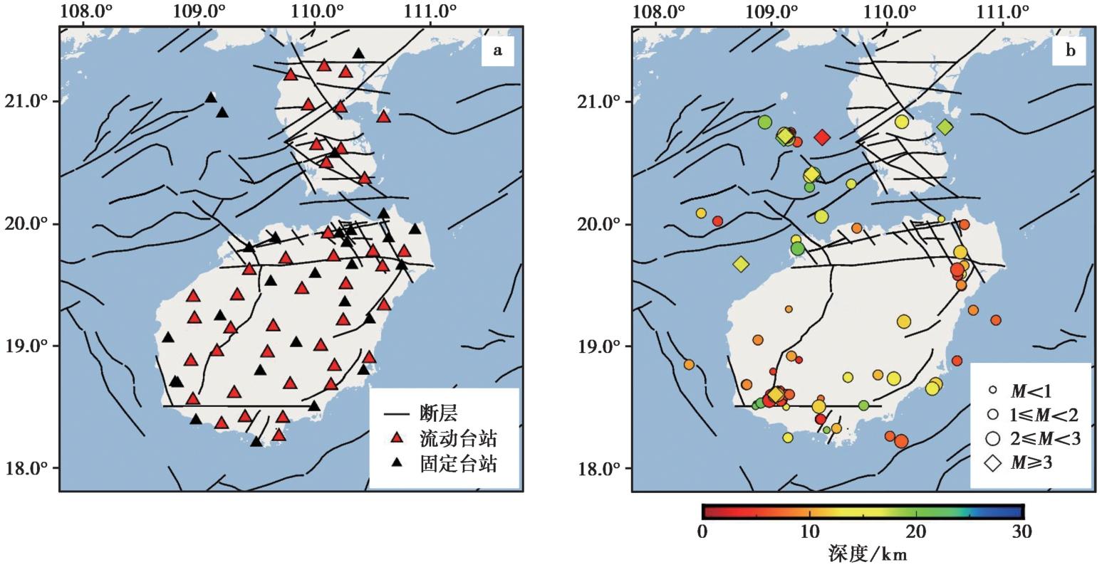
Fig. 2 Distribution of seismic stations used in this study(a) and distribution of earthquakes(b) from the CENC(March 2023-August 2024).
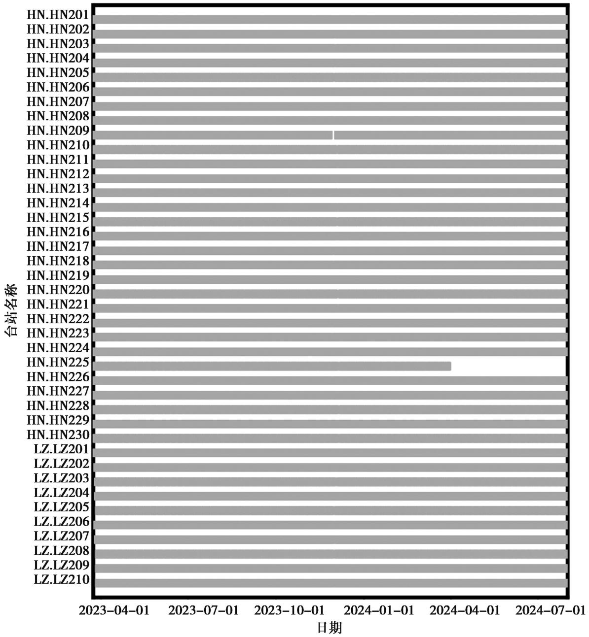
Fig. 3 Statistical chart of continuity of observations from portable seismic stations.
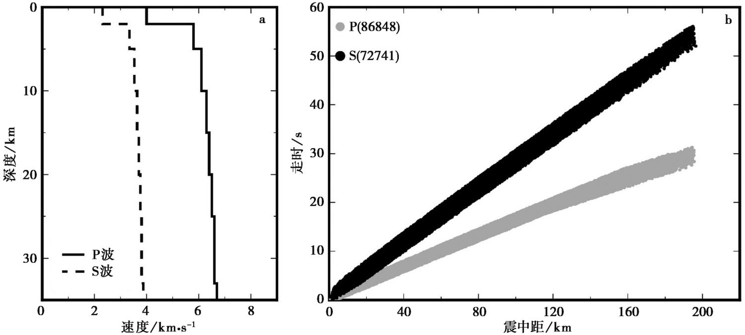
Fig. 4 One-dimensional(1D)velocity model used in this study and observed travel-time curves for P(gray dots) and S waves(black dots).
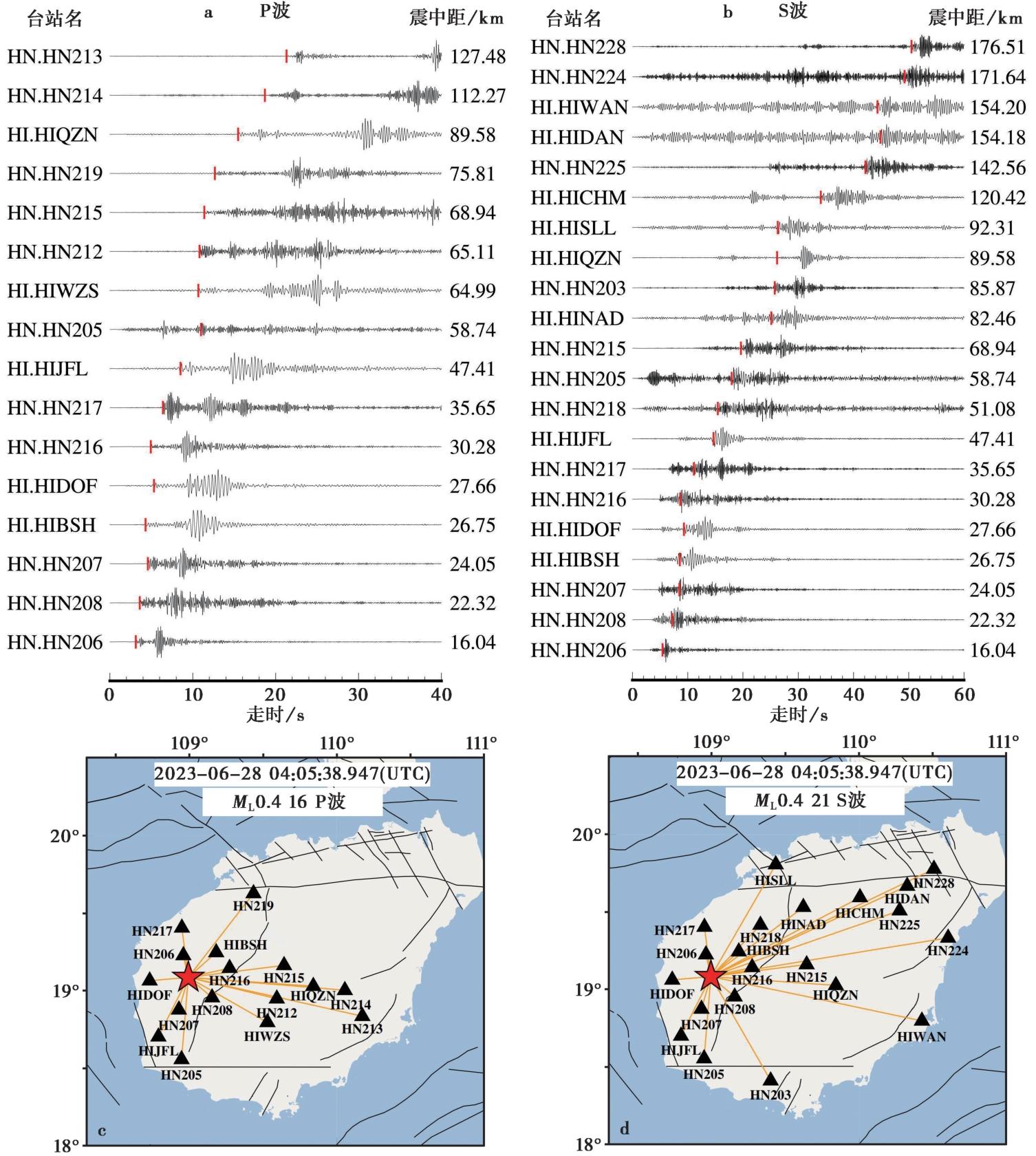
Fig. 5 Example of seismic phase picking.
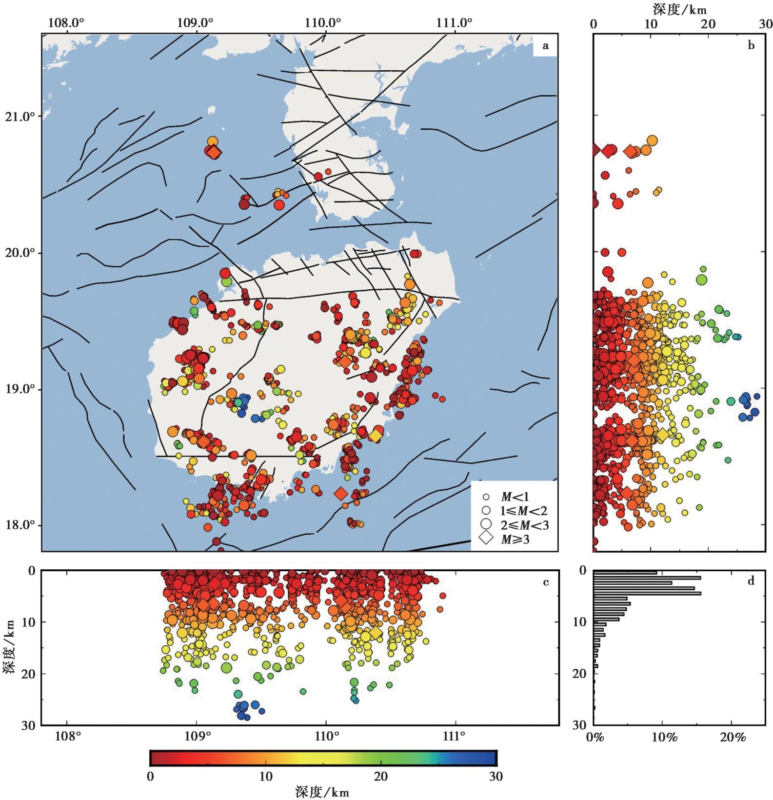
Fig. 6 Relocated earthquakes inferred from the HypoDD and cross-section.
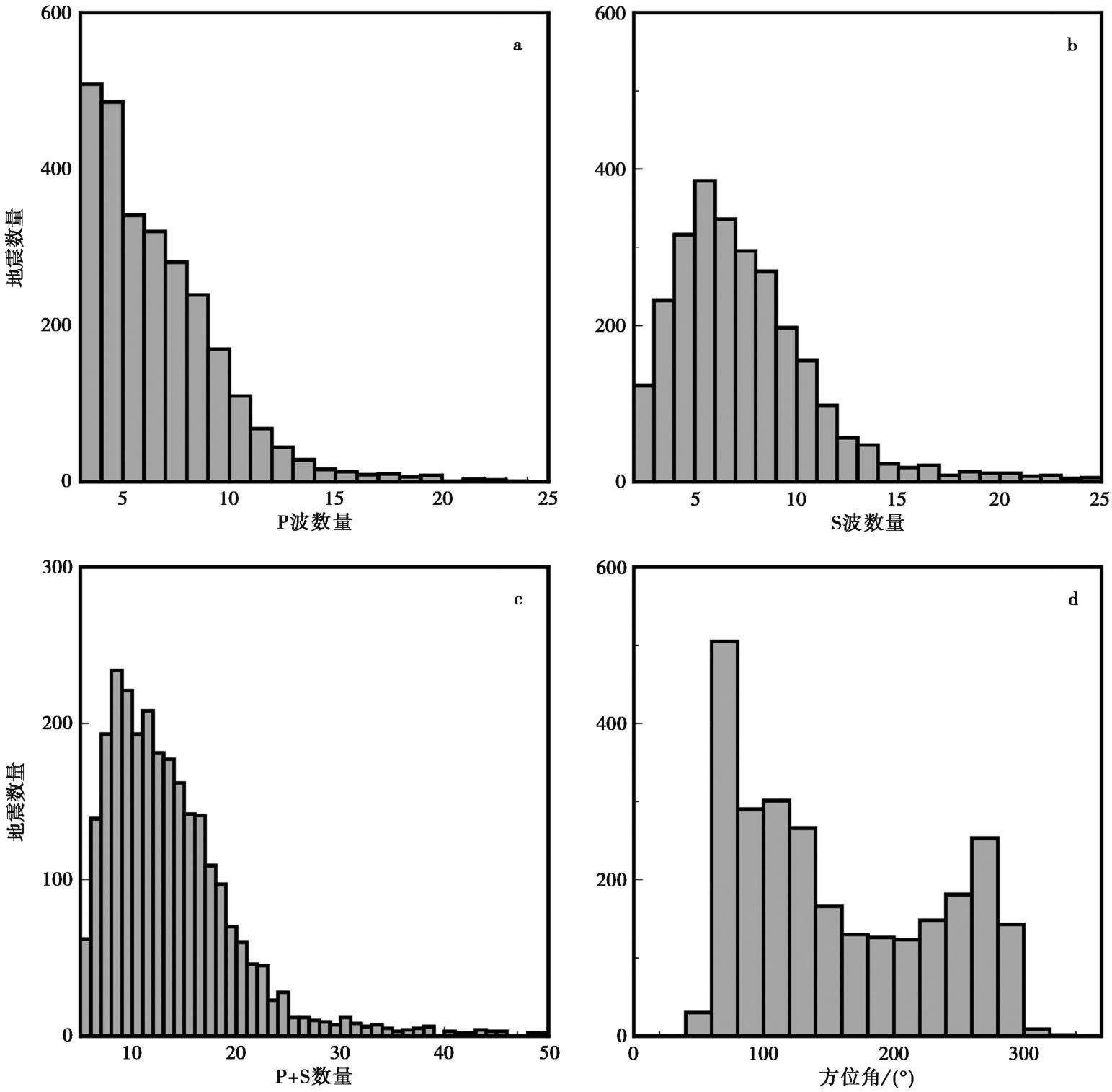
Fig. 7 Statistical distribution of seismic phases from HypoDD relocation.
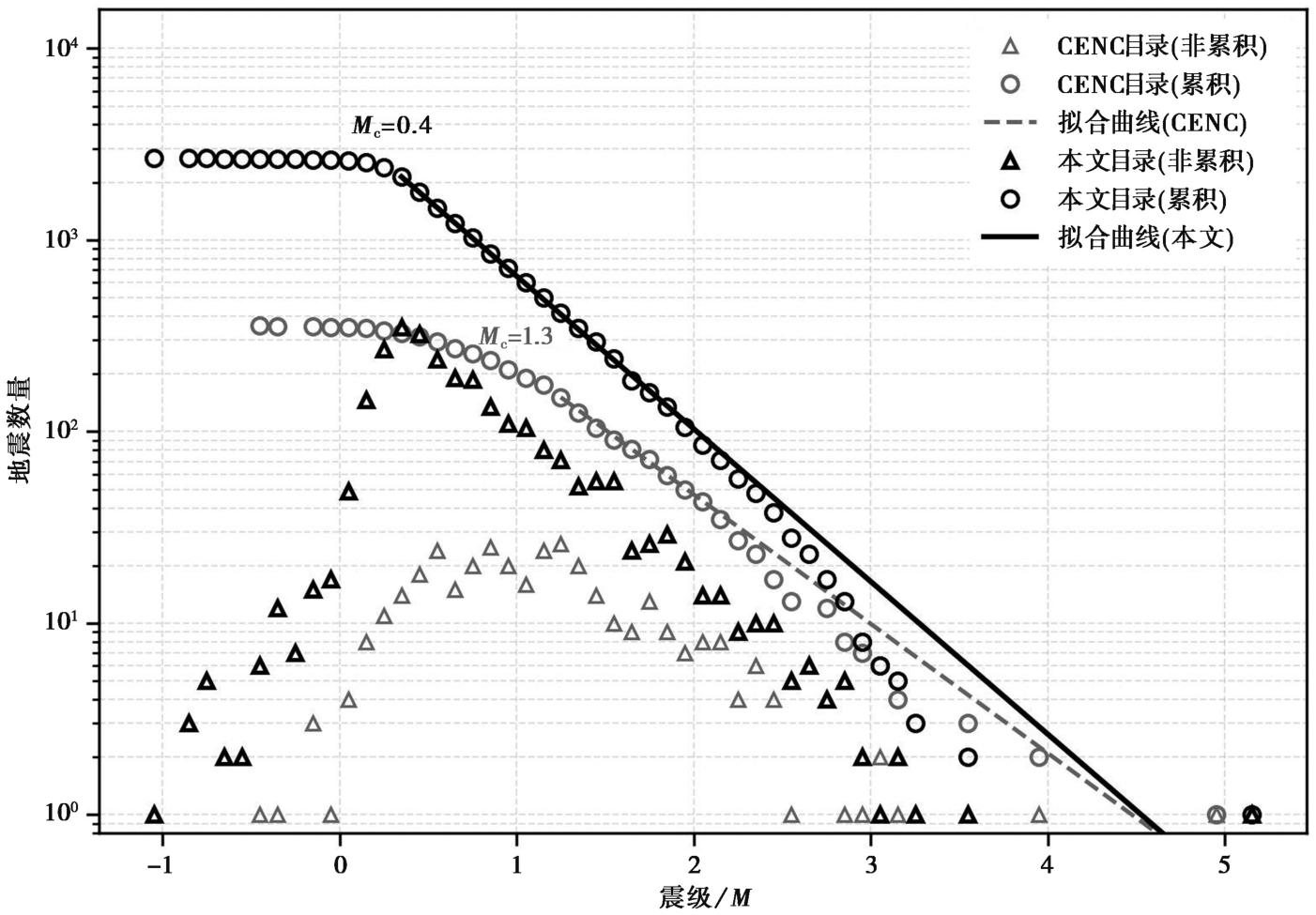
Fig. 8 Plot of magnitude versus frequency.
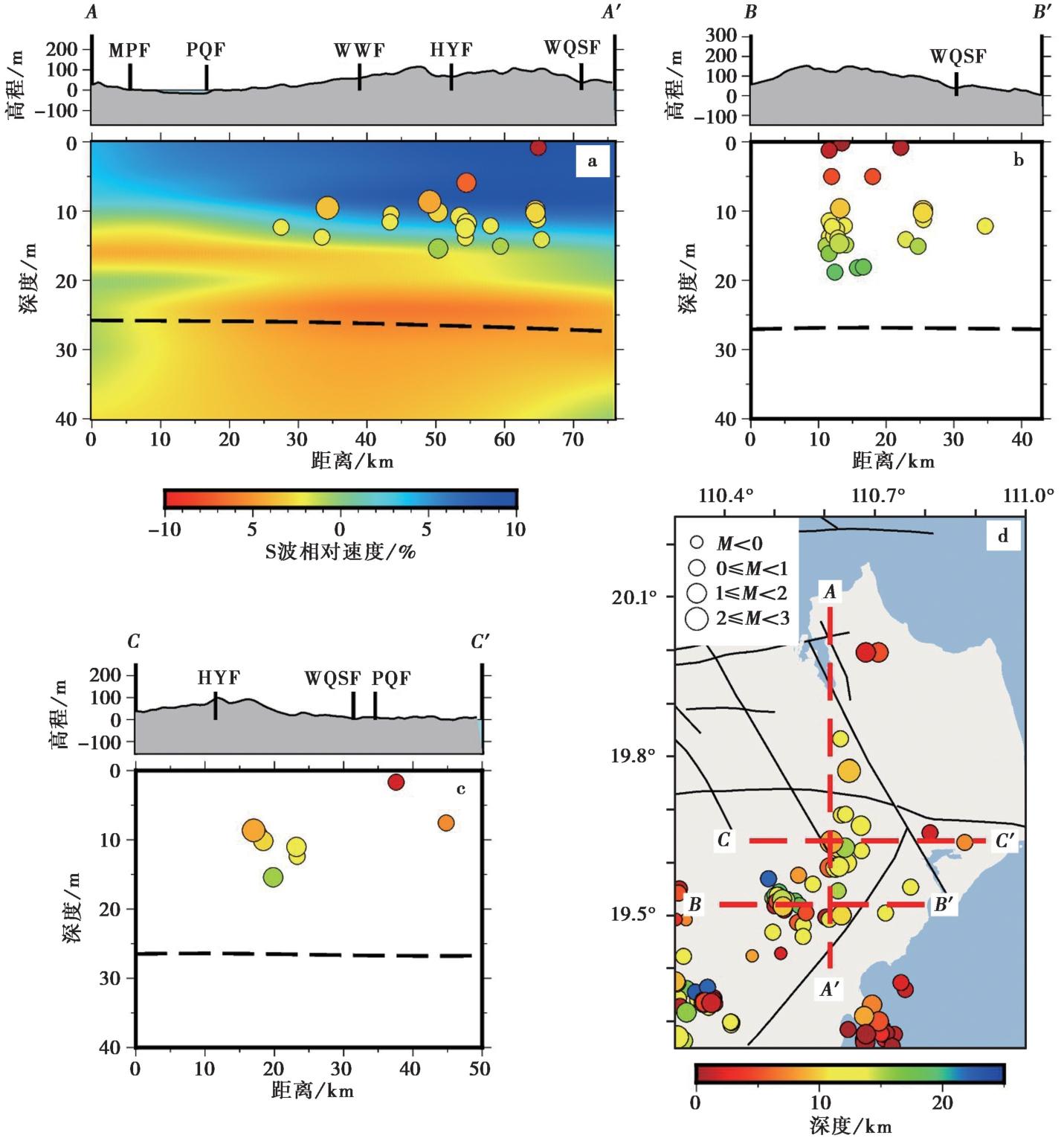
Fig. 9 Distribution of the northeastern Hainan earthquake swarm and S-wave velocity structure.
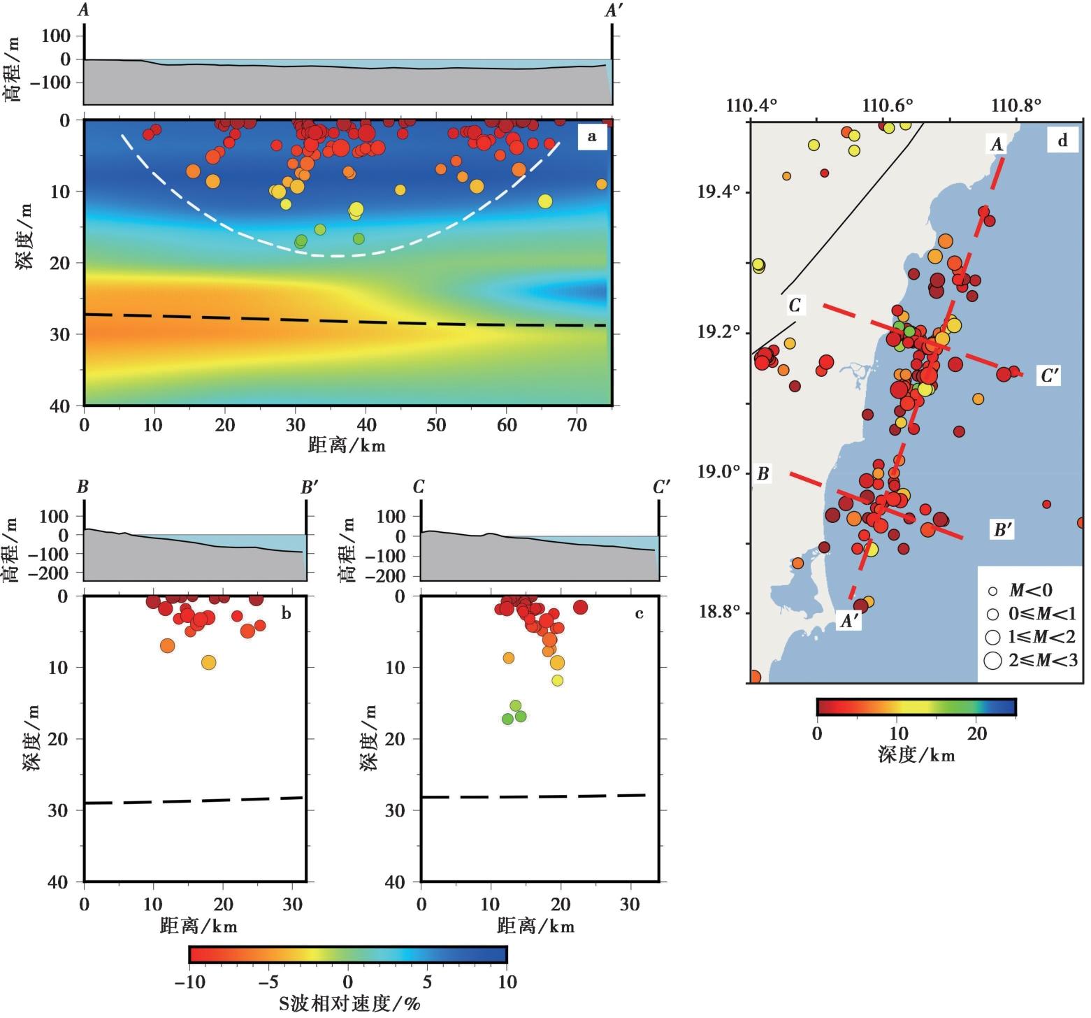
Fig. 10 Distribution of the Wanning-Wenchang earthquake swarm and S-wave velocity structure.
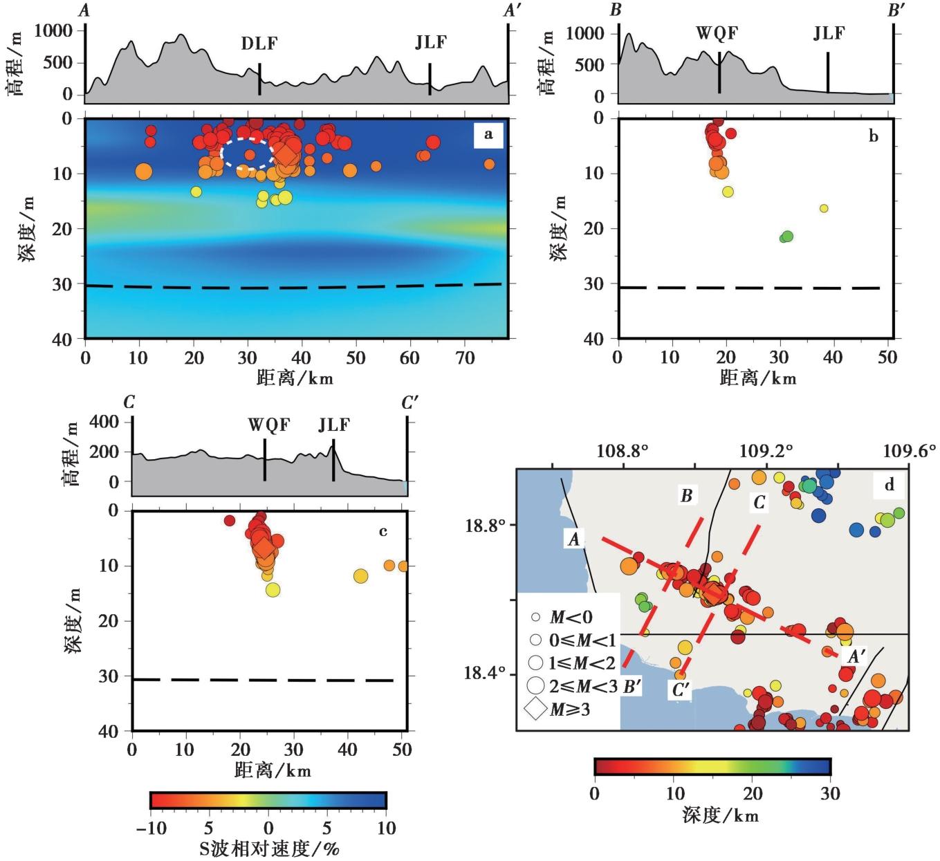
Fig. 11 Distribution of Ledong earthquake swarm and S-wave velocity structure.
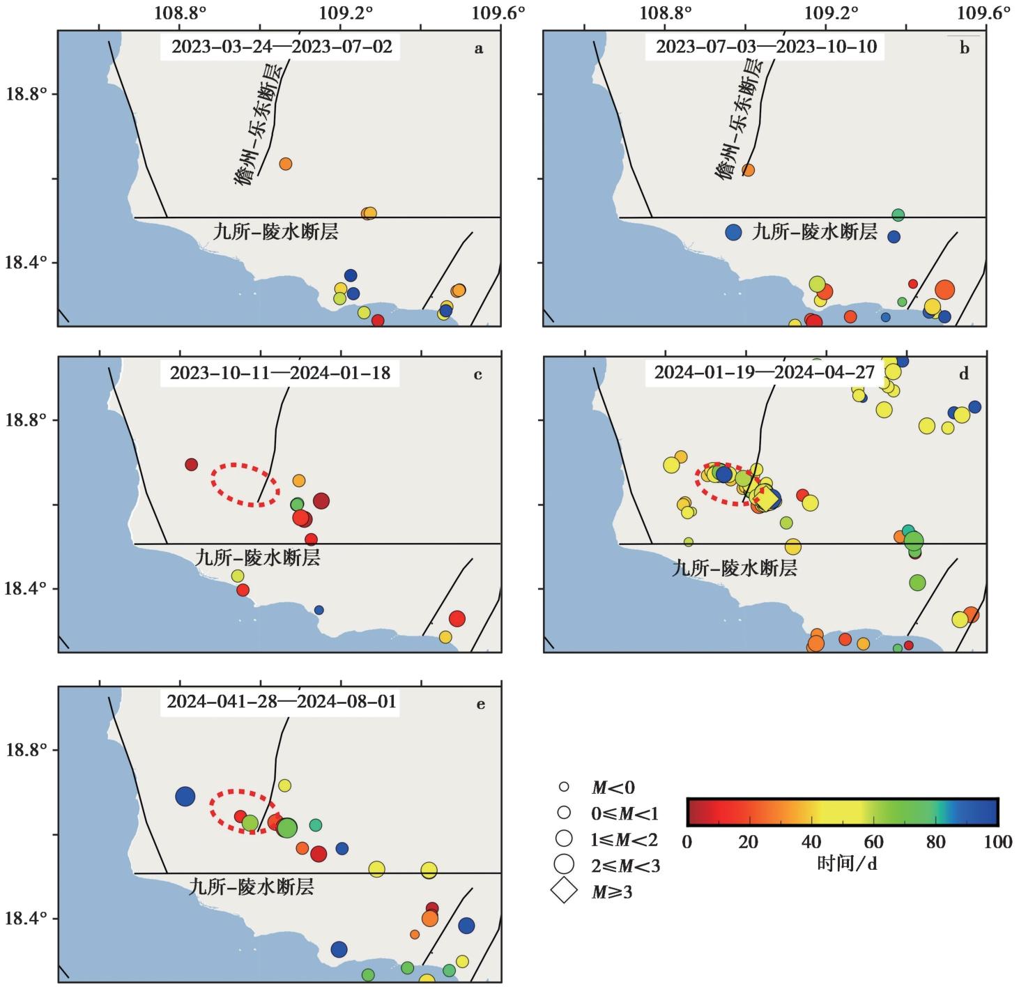
Fig. 12 Time-sequence diagram of the Ledong earthquake swarm.
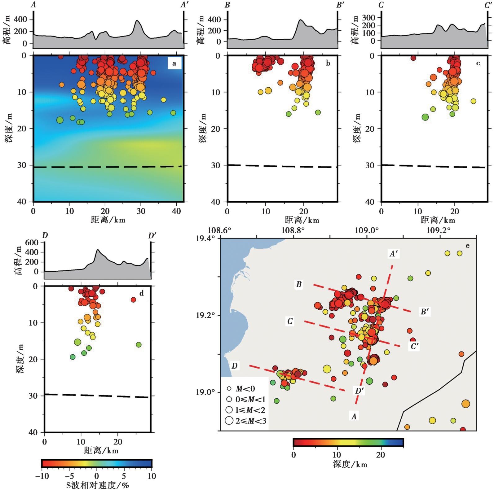
Fig. 13 Distribution of the Dongfang earthquake swarm and S-wave velocity structure.
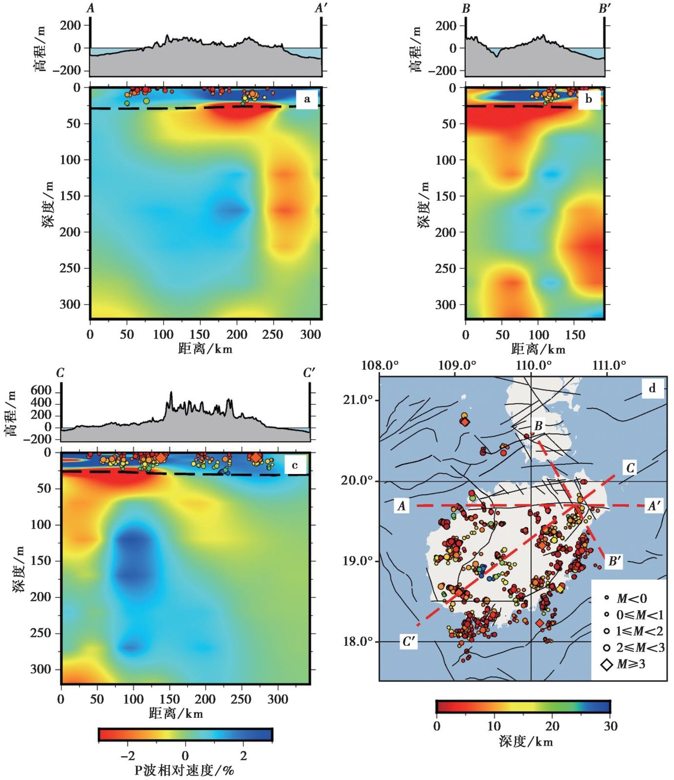
Fig. 14 Distribution of earthquakes and P-wave velocity structure around Hainan Island.
| [1] |
陈新跃, 王岳军, 韩会平, 等. 2014. 琼西南三叠纪基性岩脉年代学、 地球化学特征及其构造意义[J]. 吉林大学学报(地球科学版), 44(3): 835-847.
|
|
|
|
| [2] |
陈运平, 席道瑛, 樊星. 2002. 用分形理论研究海南岛的活动断裂[J]. 地震研究, 25(4): 351-355.
|
|
|
|
| [3] |
崔晓娜, 陈林. 2024. 幔源岩浆在地壳中分层侵位的控制因素: 二维热-力学模拟[J]. 岩石学报, 40(4): 1087-1101.
|
|
DOI URL |
|
| [4] |
丁莹莹, 赵希涛, 胡道功, 等. 2018. 琼东北晚新生代断裂活动及其对东寨港沉降的控制作用[J]. 地球学报, 39(2): 155-166.
|
|
|
|
| [5] |
郭慧丽, 常利军, 鲁来玉, 等. 2022. 基于深度学习震相拾取和密集台阵数据构建青海玛多 MS7.4 地震震源区高分辨率地震目录[J]. 地球物理学报, 65(5): 1628-1643.
|
|
|
|
| [6] |
郭昱琴, 李盛. 2016. 海南陵水近海ML5.3地震前后琼东南地区地震活动特征[J]. 四川地震, (4): 31-34.
|
|
|
|
| [7] |
郭云飞, 雷建设, 关鹏虎. 2025. 海南岛及邻区中小地震重定位[J]. CT理论与应用研究, 34(2): 191-204.
|
|
|
|
| [8] |
和泰名, 李世愚, 张洪魁, 等. 2011. 滑动弱化模型下的库仑应力变化与远程触发问题[J]. 地震学报, 33(2): 165-186.
|
|
|
|
| [9] |
何衍鑫, 田伟, 刘平平, 等. 2024. 琼北玛珥火山的结构特征及其对喷发历史和火山灾害的启示[J]. 岩石学报, 40(7): 2103-2121.
|
|
DOI URL |
|
| [10] |
胡亚轩, 郝明, 秦姗兰, 等. 2018. 海南岛现今三维地壳运动与断裂活动性研究[J]. 地球物理学报, 61(6): 2310-2321.
DOI |
|
|
|
| [11] |
惠格格, 郑江龙, 何骁慧, 等. 2025. 1605年琼州大地震发震构造特征及其现今活动性[J]. 大地构造与成矿学, 49(5): 1051-1061.
|
|
|
|
| [12] |
贾丽云, 马秀敏, 姜景捷, 等. 2023. 1605年琼山M7½级地震区现今地应力动态变化特征及对东寨港沉陷的指示意义[J]. 地质力学学报, 29(3): 339-354.
|
|
|
|
| [13] |
姜效典, 李巍然. 1994. 海南岛潜在震源区的研究[J]. 自然灾害学报, 3(1): 104-109.
|
|
|
|
| [14] |
李建生. 1991. 海南岛地区断裂构造体系与区域稳定性[J]. 海洋科学, 5(3): 19-21.
|
|
|
|
| [15] |
李盛, 黄章荣, 胡久常, 等. 2023. 三亚 MS4.2 地震前后海南岛重力场变化及其小波多尺度分解[J]. 大地测量与地球动力学, 43(9): 945-949.
|
|
|
|
| [16] |
李志刚, 张培震, 惠格格, 等. 2022. 南海北部滨海断裂带的深部结构探测现状和展望[J]. 中山大学学报(自然科学版), 61(1): 55-62.
|
|
|
|
| [17] |
刘辉, 洪汉净, 冉洪流, 等. 2008. 琼北火山群形成的动力学机制及地震现象的新认识[J]. 地球物理学报, 51(6): 1804-1809.
|
|
|
|
| [18] |
吕作勇, 丘学林, 马晓静, 等. 2017. 雷琼火山与华夏块体的远震P波走时成像[J]. 地球物理学报, 60(12): 4569-4579.
|
|
|
|
| [19] |
麻福洋, 彭利媚, 陈祥开, 等. 2019. 应力降与海南地震活动关系研究[J]. 国际地震动态, (12): 28-35.
|
|
|
|
| [20] |
孙佩雯, 彭利媚, 李冬雅, 等. 2020. 海南三亚4.2级、 3.2级地震的波形特征和震源新参数[J]. 华南地震, 40(4): 93-100.
|
|
|
|
| [21] |
孙权, 裴顺平, 郭震, 等. 2022. 结构控制的凹凸体对大地震孕育的重要作用[J]. 地球与行星物理论评, 53(2): 138-147.
|
|
|
|
| [22] |
孙伟, 杜建军, 韩帅, 等. 2021. 2019年8月海南岛三亚地震的控震断裂及未来地震危险性分析[J]. 防灾科技学院学报, 21(1): 36-45.
|
|
|
|
| [23] |
孙翔宇, 詹艳, 赵国泽, 等. 2020. 琼东北马鞍岭-雷虎岭火山区深部岩浆系统大地电磁三维探测[J]. 地震地质, 42(3): 640-653. doi: 10.3969/j.issn.0253-4967.2020.03.007.
|
|
DOI |
|
| [24] |
王晨阳, 黄金莉. 2012. 应用接收函数方法研究海南及其邻区地幔转换带结构[J]. 地球物理学报, 55(4): 1161-1167.
|
|
|
|
| [25] |
王锡娇, 魏费翔, 王佳龙, 等. 2024. 海南岛温泉气体地球化学特征研究[J]. 内陆地震, 38(1): 13-21.
DOI |
|
DOI |
|
| [26] |
夏少红, 林江南, 曹敬贺. 2022. 南海北部沿海地区地震活动与发震构造[J]. 大地构造与成矿学, 46(3): 455-470.
|
|
|
|
| [27] |
许德如, 梁新权, 唐红峰. 2000. 琼西抱板群变质基性火山岩的地球化学特征及其大地构造意义[J]. 大地构造与成矿学, 24(4): 303-313.
|
|
|
|
| [28] |
徐晓枫, 王惠琳, 陈小敏. 2014. 海南岛及邻区地震精确定位及断裂构造分析[J]. 地震研究, 37(2): 216-221.
|
|
|
|
| [29] |
鄢全树, 石学法. 2007. 海南地幔柱与南海形成演化[J]. 高校地质学报, 13(2): 311-322.
|
|
|
|
| [30] |
张新东, 王晓山, 沈繁銮, 等. 2013. 由现今小震资料研究琼北地区区域应力场和发震构造[J]. 地震学报, 35(4): 451-460.
|
|
|
|
| [31] |
张振克, 孟红明, 王万芳, 等. 2008. 海南岛1605年历史地震的海岸沉积记录[J]. 海洋地质与第四纪地质, 28(3): 9-14.
|
|
|
|
| [32] |
赵慈平, 胡久常, 周艺颖, 等. 2023. 雷琼火山现今幔源流体释放及气体源区温度研究[J]. 第四纪研究, 43(2): 458-472.
|
|
|
|
| [33] |
赵明辉, 丘学林, 叶春明, 等. 2004. 南海东北部海陆深地震联测与滨海断裂带两侧地壳结构分析[J]. 地球物理学报, 47(5): 845-852.
|
|
|
|
| [34] |
周斌, 孙峰, 阎春恒, 等. 2014. 龙滩水库诱发地震三维孔隙弹性有限元数值模拟[J]. 地球物理学报, 57(9): 2846-2868.
DOI |
|
|
|
| [35] |
周荣茂, 陈运泰, 吴忠良. 1999. 由矩张量反演得到的海南东方震群的震源机制[J]. 地震学报, 21(4): 337-343.
|
|
|
|
| [36] |
朱炳泉, 王慧芬. 1989. 雷琼地区MORB-OIB过渡型地幔源火山作用的Nd-Sr-Pb同位素证据[J]. 地球化学, (3): 193-201.
|
|
|
|
| [37] |
|
| [38] |
DOI URL |
| [39] |
|
| [40] |
DOI URL |
| [41] |
|
| [42] |
|
| [43] |
DOI URL |
| [44] |
DOI URL |
| [45] |
DOI URL |
| [46] |
DOI URL |
| [47] |
DOI URL |
| [48] |
|
| [49] |
DOI |
| [50] |
DOI URL |
| [51] |
DOI URL |
| [52] |
|
| [53] |
|
| [54] |
|
| [55] |
DOI URL |
| [56] |
|
| [57] |
|
| [58] |
DOI URL |
| [59] |
DOI URL |
| [60] |
DOI URL |
| [61] |
DOI |
| [62] |
|
| [63] |
DOI URL |
| [64] |
DOI PMID |
| [65] |
DOI URL |
| [66] |
|
| [67] |
DOI URL |
| [68] |
|
| [69] |
DOI |
| [70] |
DOI URL |
| [71] |
|
| [72] |
DOI URL |
| [73] |
|
| [74] |
DOI URL |
| [75] |
|
| [1] | DENG Zi-yu, CHEN Cheng-feng, ZHANG Rui-qing, QIANG Zheng-yang, TIAN Wen. EARTHQUAKE RELOCATION AND b-VALUE SPATIOTEMPORAL VARIATION IN WEIYUAN, SICHUAN BASIN, CHINA [J]. SEISMOLOGY AND GEOLOGY, 2026, 48(4): 1052-1067. |
| [2] | WANG Hui-lin, XU Xiao-feng, ZHOU Long-quan, ZHANG Xiao-dong, SHEN Fan-lua, LI Zhi-xiong, ZHAN Wei. CRUSTAL Qs TOMOGRAPHY IN HAINAN ISLAND AND ADJACENT REGIONS [J]. SEISMOLOGY AND GEOLOGY, 2016, 38(3): 631-645. |
| [3] | SUN Qian, FAN Qi-cheng. DYNAMIC MECHANISM OF PHREATOMAGMATIC ERUPTION IN NORTHERN HAINAN ISLAND [J]. SEISMOLOGY AND GEOLOGY, 2005, 27(1): 63-72. |
| [4] | SHI Lan-Bin, LIN Chuan-Yong, CHEN Xiao-De, ZHANG Bing-Liang. DISCOVERY OF MANTLE-DERIVED MICRO-XENOLITHS FROM QUATERNARY BASALTS IN NORTHERN HAINAN ISLAND AND ITS GEOLOGICAL IMPLICATION [J]. SEISMOLOGY AND GEOLOGY, 2003, 25(s1): 33-42. |
| [5] | WEI Hai-Quan, BAI Zhi-Da, HU Jiu-Chang, SHI Lan-Bin, ZHANG Bing-Liang, XU De-Bin, SUN Qian, FAN Qi-Cheng. NOMENCLATURE OF THE HOLOCENE VOLCANIC SYSTEMS AND RESEARCH ON THE TEXTURAL PARAMETERS OF THE SCORIA CONES IN NORTHERN HAINAN ISLAND [J]. SEISMOLOGY AND GEOLOGY, 2003, 25(s1): 21-32. |
| [6] | ZHANG Bing-liang, HONG Han-jing, SHI Lan-bin, LIN Chuan-yong, LI Jian-ping. WEATHERING FEATURES OF VOLCANIC EJECTA IN THE NORTHERN HAINAN ISLAND AND THEIR IMPLICATIONS [J]. SEISMOLOGY AND GEOLOGY, 2003, 25(3): 430-437. |
| [7] | SUN Qian, FAN Qi-cheng, WEI Hai-quan, SUI Jian-li, BAI Zhi-da, XU De-bin, SHI Lan-bin, ZHANG Bing-liang, HONG Han-jing. PRELIMINARY STUDY ON LATE PLEISTOCENE PHREATO-MAGMATIC ERUPTIONS IN NORTHERN HAINAN ISLAND [J]. SEISMOLOGY AND GEOLOGY, 2003, 25(2): 289-297. |
| [8] | Xue Guang-ying, Feng Rui. RECONSTRUCTION OF THE BASEMENT VELOCITY IMAGE BASED ON HEAD WAVE [J]. SEISMOLOGY AND GEOLOGY, 1990, 12(2): 141-148. |
| Viewed | ||||||
|
Full text |
|
|||||
|
Abstract |
|
|||||
Copyright © SEISMOLOGY AND GEOLOGY, All Rights Reserved.
Tel: 010-62009049/9063 E-mail: dzdz@ies.ac.cn
Powered by Beijing Magtech Co., Ltd.