
SEISMOLOGY AND GEOLOGY ›› 2026, Vol. 48 ›› Issue (4): 1052-1067.DOI: 10.3969/j.issn.0253-4967.20250063
• Research paper • Previous Articles Next Articles
EARTHQUAKE RELOCATION AND b-VALUE SPATIOTEMPORAL VARIATION IN WEIYUAN, SICHUAN BASIN, CHINA
DENG Zi-yu1)( ), CHEN Cheng-feng1), ZHANG Rui-qing1,2),*(), QIANG Zheng-yang1,2), TIAN Wen1)
- 1)
Institute of Geophysics ,China Earthquake Administration
2)State Key Laboratory of Earthquake Dynamics and Forecasting ,Institute of Geophysics, China Earthquake Administration
-
Received:2025-03-07Revised:2025-05-28Online:2026-08-20Published:2026-09-09
川南威远地区地震重定位及b值的时空演化特征
邓子玉1)(), 陈成锋1), 张瑞青1,2),*(), 强正阳1,2), 田雯1)
- 1)
中国地震局地球物理研究所
2)地震动力学与强震预测全国重点实验室 ,中国地震局地球物理研究所
-
通讯作者:* 张瑞青, 女, 1973年生, 研究员, 博士生导师, 主要从事地球深部结构探测研究, E-mail: zrq@cea-igp.ac.cn。 -
作者简介:邓子玉, 女, 1999年生, 2025年于中国地震局地球物理研究所获得硕士学位, 主要从事地震检测与定位研究, E-mail: dengzy202408@163.com。
-
基金资助:国家自然科学基金(42474133)

Cite this article
DENG Zi-yu, CHEN Cheng-feng, ZHANG Rui-qing, QIANG Zheng-yang, TIAN Wen. EARTHQUAKE RELOCATION AND b-VALUE SPATIOTEMPORAL VARIATION IN WEIYUAN, SICHUAN BASIN, CHINA[J]. SEISMOLOGY AND GEOLOGY, 2026, 48(4): 1052-1067.
邓子玉, 陈成锋, 张瑞青, 强正阳, 田雯. 川南威远地区地震重定位及b值的时空演化特征[J]. 地震地质, 2026, 48(4): 1052-1067.
share this article
Add to citation manager EndNote|Ris|BibTeX
URL: https://www.dzdz.ac.cn/EN/10.3969/j.issn.0253-4967.20250063
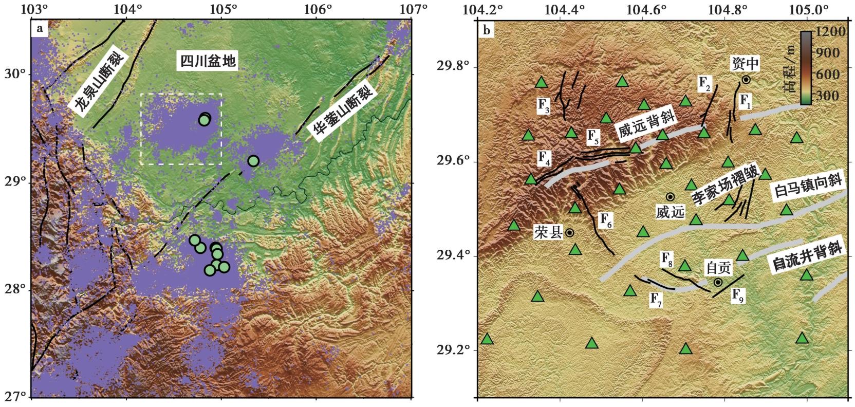
Fig. 1 Tectonic background of southern Sichuan Basin(a), and distribution of the temporary seismic stations in and around the Weiyuan region(b).
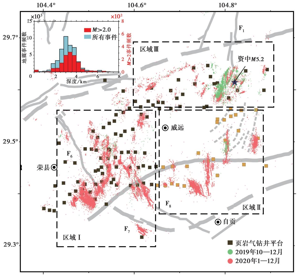
Fig. 2 Map view of epicentral distributions of relocated earthquakes in and around the Weiyuan region.
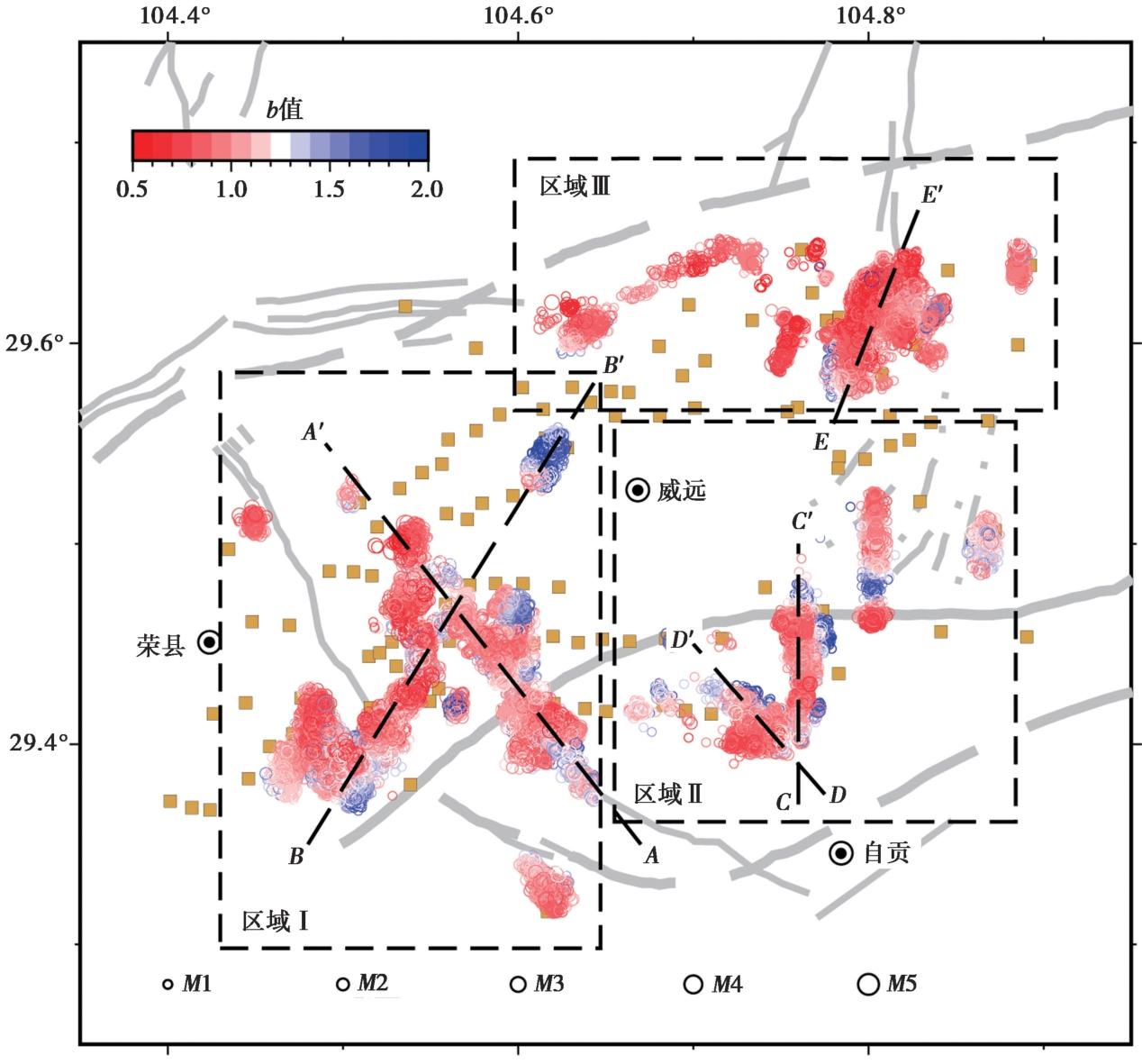
Fig. 3 Spatial distribution of the b-values in Weiyuan and its surrounding region.
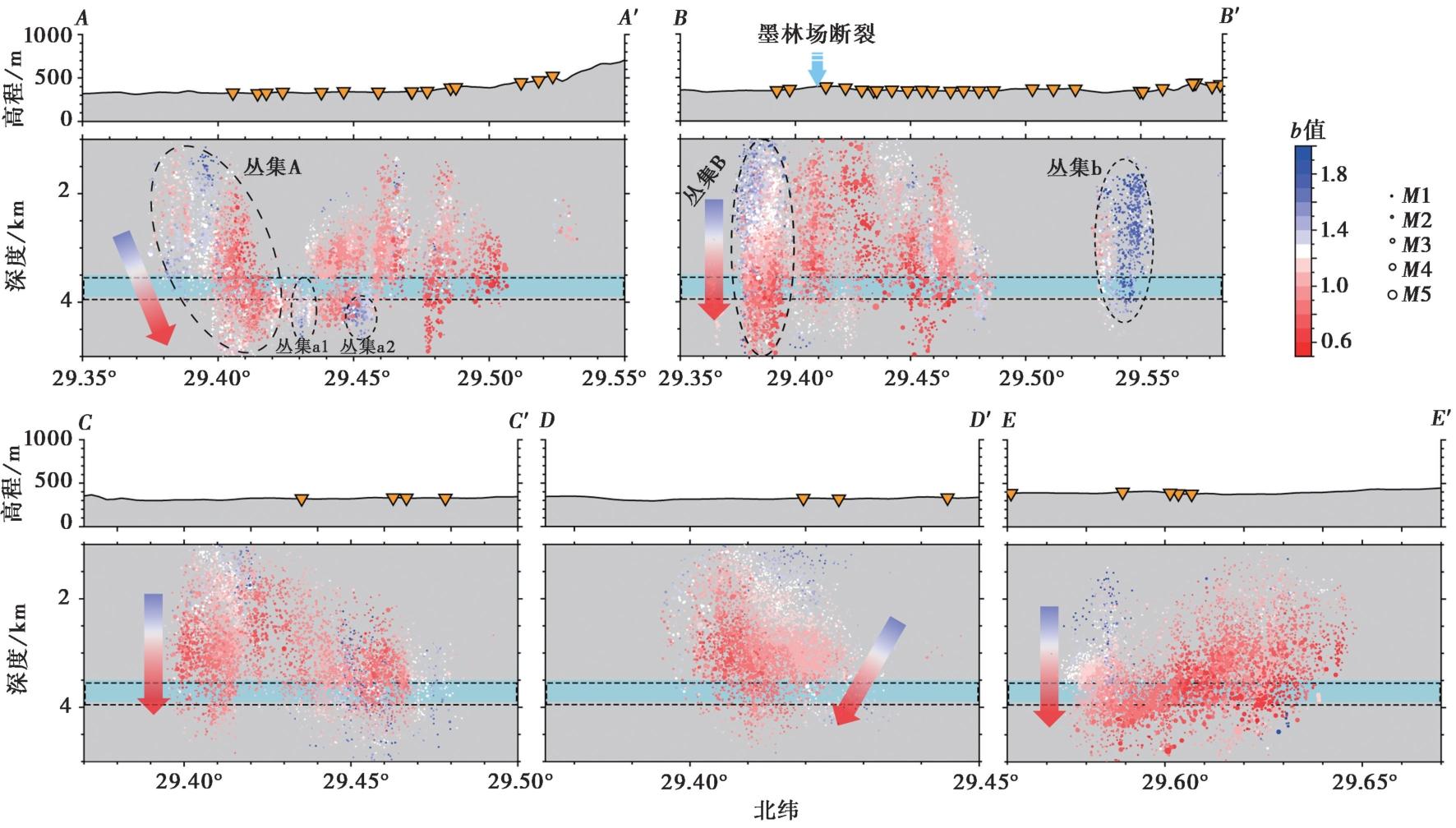
Fig. 4 Distribution of seismic b-values along the AA'-EE' surey line.
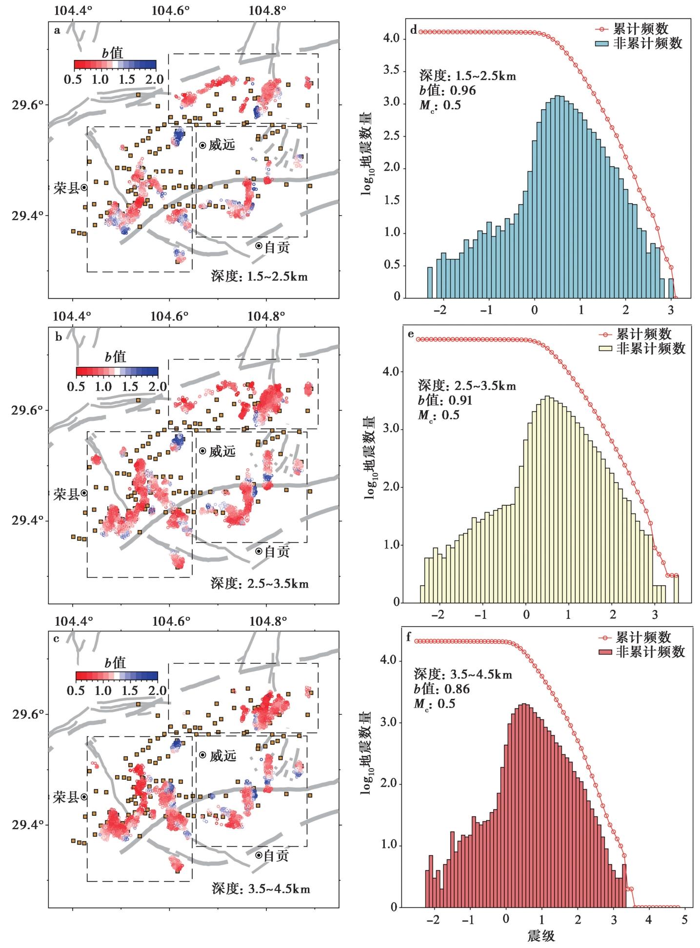
Fig. 5 Maps of the b-value for each earthquake and all events within depths of 1.5-2.5km, 2.5-3.5km and 3.5-4.5km, respectively.
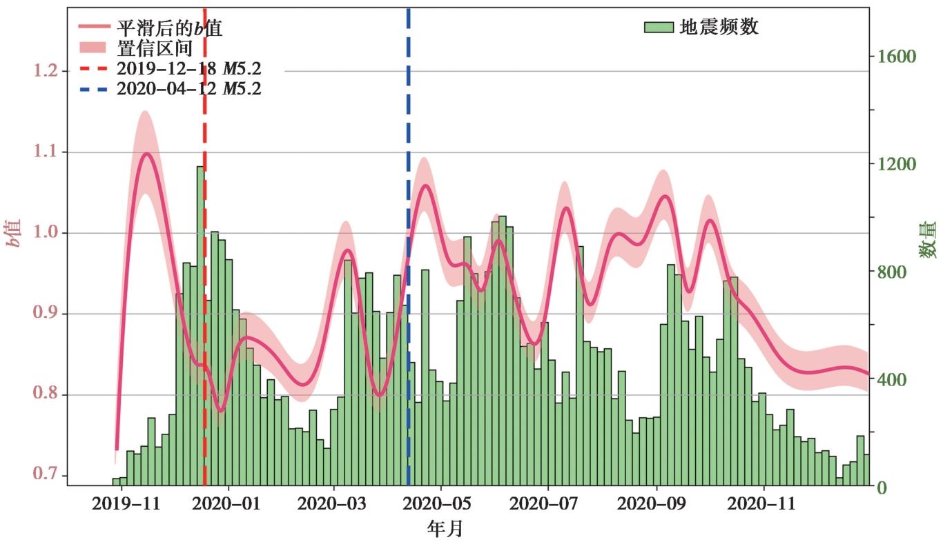
Fig. 6 The temporal evolution of b-values during the observation period.
| [1] |
邓宾, 刘树根, 王国芝, 等. 2013. 四川盆地南部地区新生代隆升剥露研究: 低温热年代学证据[J]. 地球物理学报, 56(6): 1958—1973.
|
|
|
|
| [2] |
杜广宝, 吴庆举, 张雪梅, 等. 2021. 四川威远及邻区中小地震活动特征及地壳精细结构研究[J]. 地球物理学报, 64(11): 3983—3996.
DOI |
|
|
|
| [3] |
谷志东, 殷积峰, 袁苗, 等. 2015. 四川盆地东部深层盐下震旦系—寒武系天然气成藏条件与勘探方向[J]. 石油勘探与开发, 42(2): 137—149.
|
|
|
|
| [4] |
韩佳东, 杨建思, 王伟平. 2019. 2017年西藏米林 MS6.9 地震余震序列重定位和b值时空分布特征[J]. 地震学报, 41(2): 169—180.
|
|
|
|
| [5] |
黄柳, 赵爱华, 吴庆举, 等. 2024. 基于密集台阵的四川长宁页岩气开发区地震b值特征分析[J]. 地震学报, 46(5): 825—843.
|
|
|
|
| [6] |
金宠, 李三忠, 王岳军, 等. 2009. 雪峰山陆内复合构造系统印支—燕山期构造穿时递进特征[J]. 石油与天然气地质, 30(5): 598—607.
|
|
|
|
| [7] |
刘雁冰, 裴顺平. 2017. 汶川地震前后b值的时空变化及构造意义[J]. 地球物理学报, 60(6): 2104—2112.
DOI |
|
|
|
| [8] |
刘子璇. 2020. 南北地震带b值震前异常特征研究[D]. 兰州: 中国地震局兰州地震研究所.
|
|
|
|
| [9] |
马林飞, 陶玮, 张永, 等. 2018. 龙门山断层地震周期及其动力学过程模拟研究[J]. 地球物理学报, 61(5): 1824—1839.
DOI |
|
|
|
| [10] |
庞河清, 熊亮, 魏力民, 等. 2019. 川南深层页岩气富集高产主要地质因素分析: 以威荣页岩气田为例[J]. 天然气工业, 39(S1): 78—84.
|
|
|
|
| [11] |
石耀霖, 曹建玲. 2010. 库仑应力计算及应用过程中若干问题的讨论: 以汶川地震为例[J]. 地球物理学报, 53(1): 102—110.
|
|
|
|
| [12] |
四川省地质局. 1980. 区域地质报告(遂宁幅、 自贡幅、 内江幅、 宜宾幅、 泸州幅)[R]. 成都: 四川省地质局.
|
|
Sichuan Geology Bureau. 1980. Regional geological survey report(Suining, Zigong, Neijiang, Yibin and Luzhou geological map sheet, 1︰200 000)[R]. Sichuan Geology Bureau, Chengdu (in Chinese).
|
|
| [13] |
王鸿祯, 张世红. 2002. 全球前寒武纪基底构造格局与古大陆再造问题[J]. 地球科学, 27(5): 467—481.
|
|
|
|
| [14] |
徐炳高. 1997. 四川省威远地区燕山早期的构造反转及威远背斜雏形的形成[J]. 四川地质学报, 17(2): 96—102.
|
|
|
|
| [15] |
易桂喜, 龙锋, 梁明剑, 等. 2020. 四川盆地荣县—威远—资中地区发震构造几何结构与构造变形特征: 基于震源机制解的认识和启示[J]. 地球物理学报, 63(9): 3275—3291.
DOI |
|
|
|
| [16] |
DOI |
| [17] |
DOI URL |
| [18] |
DOI URL |
| [19] |
DOI |
| [20] |
DOI URL |
| [21] |
DOI URL |
| [22] |
DOI URL |
| [23] |
|
| [24] |
|
| [25] |
DOI URL |
| [26] |
|
| [27] |
DOI URL |
| [28] |
|
| [29] |
DOI |
| [30] |
DOI URL |
| [31] |
DOI URL |
| [32] |
|
| [33] |
DOI URL |
| [34] |
DOI URL |
| [35] |
DOI URL |
| [36] |
|
| [37] |
|
| [38] |
DOI URL |
| [39] |
DOI URL |
| [40] |
DOI URL |
| [41] |
DOI URL |
| [42] |
DOI URL |
| [43] |
|
| [44] |
DOI URL |
| [45] |
|
| [46] |
DOI |
| [47] |
|
| [48] |
|
| [49] |
|
| [50] |
DOI URL |
| [1] | LI Yun-hui, LEI Jian-she, GUAN Hui-min, HU Xiao-hui, HAO Jiang-bo. GEOLOGICAL TECTONICS AND CONSTRUCTION OF A HIGH-PRECISION EARTHQUAKE CATALOG AROUND HAINAN ISLAND BY USING MACHINE LEARNING [J]. SEISMOLOGY AND GEOLOGY, 2026, 48(4): 1068-1092. |
| [2] | CHEN Li-juan, CHEN Xue-zhong, LI Yan-e, GONG Li-wen. RELATIONSHIP BETWEEN DECREASING AMPLITUDE OF b-VALUE AND THE SEISMOGENIC ZONE OF THE WENCHUAN MS8.0 EARTHQUAKE [J]. SEISMOLOGY AND GEOLOGY, 2022, 44(4): 1046-1058. |
| [3] | XUE Yan, XIE Meng-yu, LIU Jie, ZHUANG Jian-cang. STUDY ON FORESHOCK SEQUENCES OF THE GLOBA L GREAT SHALLOW-FOCUS EARTHQUAKES WITH MW≥8.0 [J]. SEISMOLOGY AND EGOLOGY, 2021, 43(5): 1233-1249. |
| [4] | LIANG Shan-shan, XU Zhi-guo, ZHANG Guang-wei, ZOU Li-ye, LIU Yan-qiong, GUO Tie-long. GEOMETRIC COMPLEXITY OF FAULT SYSTEM IN THE SOURCE REGION OF THE 2021 YANGBI, YUNNAN, MS6.4 EARTHQUAKE [J]. SEISMOLOGY AND EGOLOGY, 2021, 43(4): 827-846. |
| [5] | WANG Kai-ying, JIN Ming-pei, HUANG Ya, DANG Wen-jie, LI Wen-tao, ZHUO Yan-qun, HE Chang-rong. TEMPORAL AND SPATIAL EVOLUTION OF THE 2021 YANGBI (YUNNAN CHINA)MS6.4 EARTHQUAKE SEQUENCE [J]. SEISMOLOGY AND EGOLOGY, 2021, 43(4): 1030-1039. |
| [6] | JIANG Min, CHEN Jiu-hui, Yasuto Kuwahara, Reiken Matsushita. SPATIO-TEMPORAL STRESS FIELD VARIATION IN THE CENTRAL LONGMENSHAN FAULT ZONE AFTER THE 2008 WENCHUAN EARTHQUAKE FROM FOCAL MECHANISM SOLUTIONS OF SMALL EARTHQUAKES [J]. SEISMOLOGY AND GEOLOGY, 2018, 40(2): 310-322. |
| [7] | LEI Xing-lin, Takashi Satoh, Osamu Nishizawa. THREE-STAGE FRACTURING MODEL FOR GRANITIC ROCKS UNDER TRIAXIAL COMPRESSION-ROLE OF MICROCRACK DENSITY AND STRESS RATE ON FAULT FORMATION [J]. SEISMOLOGY AND EGOLOGY, 2004, 26(3): 436-449. |
| [8] | Liu Liqiang, Ma Shengli, Ma Jin, Hu Xiaoyan, Liu Tianchang, Wu Xiuquan. TEMPORAL SCANNING OF b-VALUE AND SPECTRUM OF AE ACTIVITY FOR SAMPLES WITH DIFFERENT TEXTURES AND THEIR PHYSICAL IMPLICATIONS [J]. SEISMOLOGY AND GEOLOGY, 2001, 23(4): 481-492. |
| [9] | Zeng Zhengwen, Ma Jin, Liu Liqiang, Liu Tianchang. AE b-VALUE DYNAMIC FEATURES DURINE ROCKMASS FRACTURING AND THEIR SIGNIFICANCES [J]. SEISMOLOGY AND GEOLOGY, 1995, 17(1): 7-12. |
| [10] | Jiao Wen-jie, Ma Jin, Wu Xiu-quan, Liu Li-qiang. EXPERIMENTAL RESEARCH ON A NEW AE EXPERIMENTAL SYSTEM FOR MEASURRING FAILURE ROCKS UNDER CONFINING PRESSURE AND THE MAGNITUDE-FREQUENCY RELATION [J]. SEISMOLOGY AND GEOLOGY, 1991, 13(1): 54-60. |
| Viewed | ||||||
|
Full text |
|
|||||
|
Abstract |
|
|||||
Copyright © SEISMOLOGY AND GEOLOGY, All Rights Reserved.
Tel: 010-62009049/9063 E-mail: dzdz@ies.ac.cn
Powered by Beijing Magtech Co., Ltd.