SEISMOLOGY AND GEOLOGY ›› 2022, Vol. 44 ›› Issue (5): 1172-1189.DOI: 10.3969/j.issn.0253-4967.2022.05.006
• Research paper • Previous Articles Next Articles
HUA Jun1)( ), GONG Wen-yu1)(), SHAN Xin-jian1), WANG Zhen-jie2), JI Ling-yun3), LIU Chuan-jin3), LI Yong-sheng4)
Received:2021-07-16
Revised:2022-03-14
Online:2022-10-20
Published:2022-11-28
Contact:
GONG Wen-yu
华俊1)(), 龚文瑜1),*(), 单新建1), 王振杰2), 季灵运3), 刘传金3), 李永生4)
通讯作者:
龚文瑜
作者简介:华俊, 男, 1996年生, 2022年于中国石油大学(华东)获测绘科学与技术专业硕士学位, 现为中国地震局地质研究所固体地球物理学专业在读博士研究生, 主要从事InSAR技术在地震及地壳形变领域的应用研究, 电话: 17854291150, E-mail: 17854291150@163.com。
基金资助:HUA Jun, GONG Wen-yu, SHAN Xin-jian, WANG Zhen-jie, JI Ling-yun, LIU Chuan-jin, LI Yong-sheng. RESEARCH ON INTEGRATING INTERSEISMIC DEFORMATION RATE FIELDS OF MULTI-TRACK INSAR[J]. SEISMOLOGY AND GEOLOGY, 2022, 44(5): 1172-1189.
华俊, 龚文瑜, 单新建, 王振杰, 季灵运, 刘传金, 李永生. 多轨道InSAR震间形变速率场拼接方法[J]. 地震地质, 2022, 44(5): 1172-1189.
Add to citation manager EndNote|Ris|BibTeX
URL: https://www.dzdz.ac.cn/EN/10.3969/j.issn.0253-4967.2022.05.006
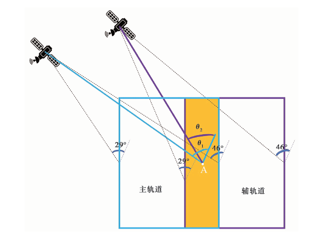
Fig. 1 Diagram of the influence of incident angle on integrating InSAR data.
| 传感器类型 | 模式 | 幅宽/km | 入射角范围 |
|---|---|---|---|
| Sentinel-1 | TOPS | 250 | 29°~46° |
| ERS | Stripmap | 100 | 20°~26° |
| ASAR | Wide Swath | 405 | 17°~42° |
| ALOS-2 | ScanSAR | 350、 490 | 32°~54° |
Table1 Detailed parameters of some SAR sensors
| 传感器类型 | 模式 | 幅宽/km | 入射角范围 |
|---|---|---|---|
| Sentinel-1 | TOPS | 250 | 29°~46° |
| ERS | Stripmap | 100 | 20°~26° |
| ASAR | Wide Swath | 405 | 17°~42° |
| ALOS-2 | ScanSAR | 350、 490 | 32°~54° |
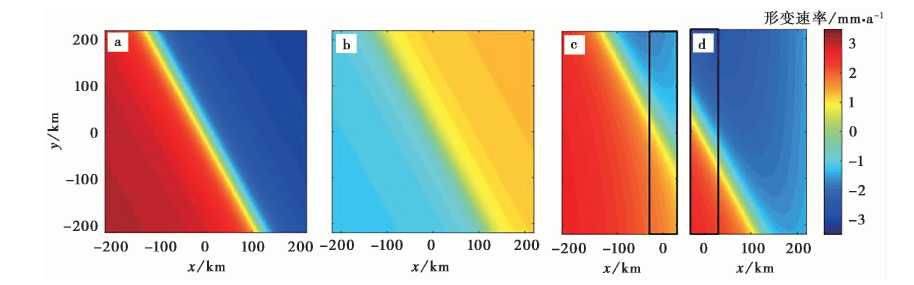
图2 Simulated interseismic displacements in LOS direction.
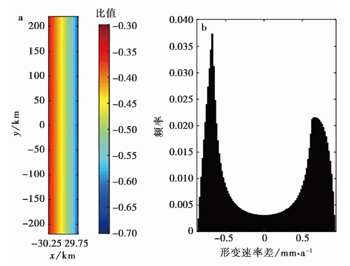
Fig. 3 Ratio map and histogram of interseismic displacement difference of adjacent track in the overlapping regions.
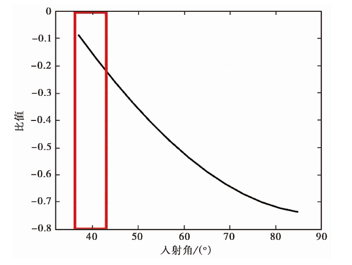
Fig. 4 The relation between ratio and incident angle.
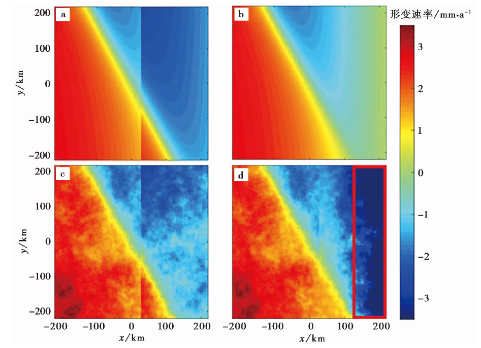
Fig. 5 The integration of simulated InSAR displacement maps over two adjacent tracks.
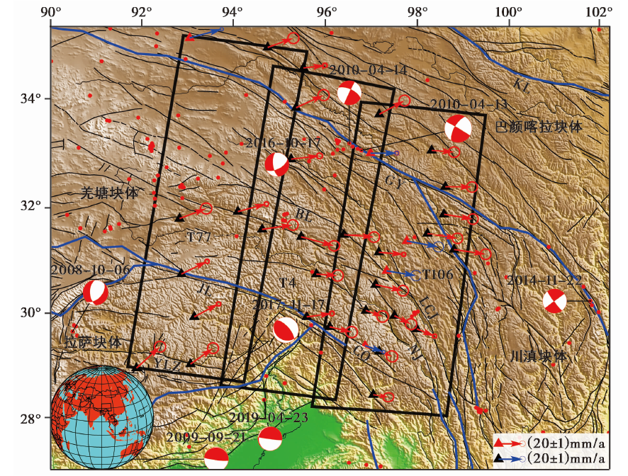
Fig. 6 Coverage of GPS and InSAR displacement rate data.
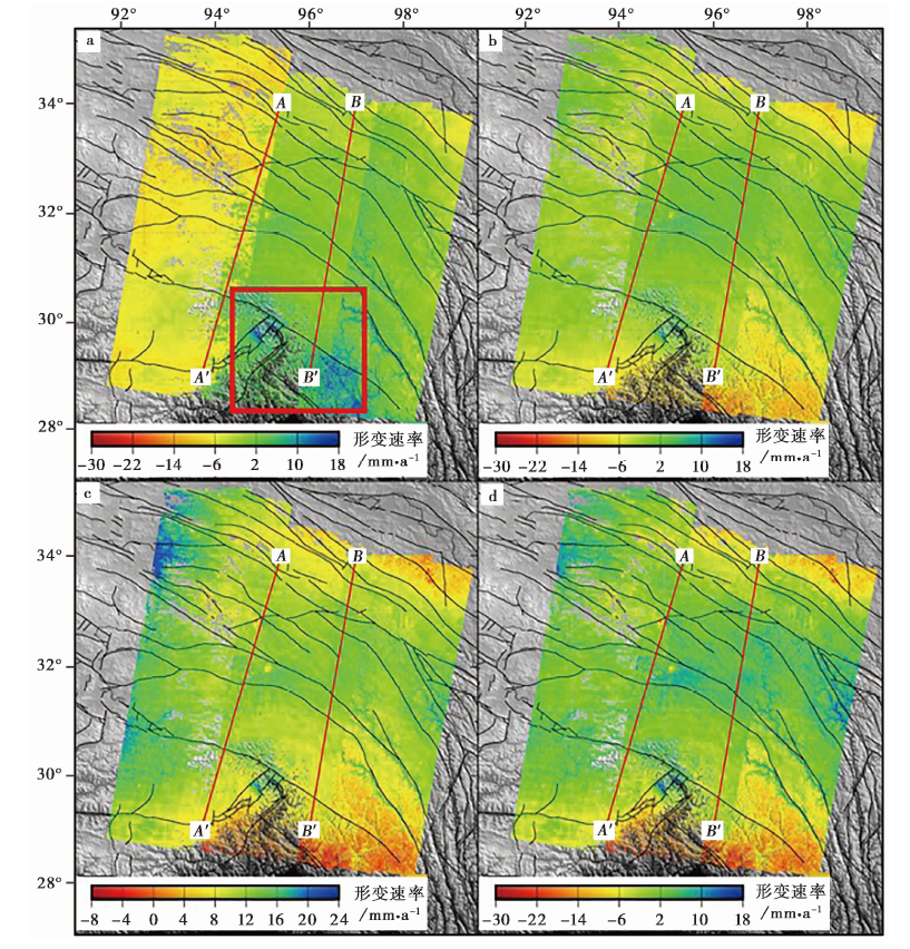
Fig. 9 InSAR displacement rate distribution.
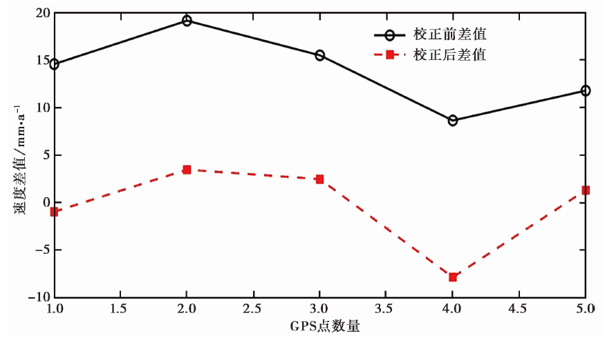
Fig. 7 Comparison of the difference between the GPS displacement rate and InSAR displacement rate before and after correction.
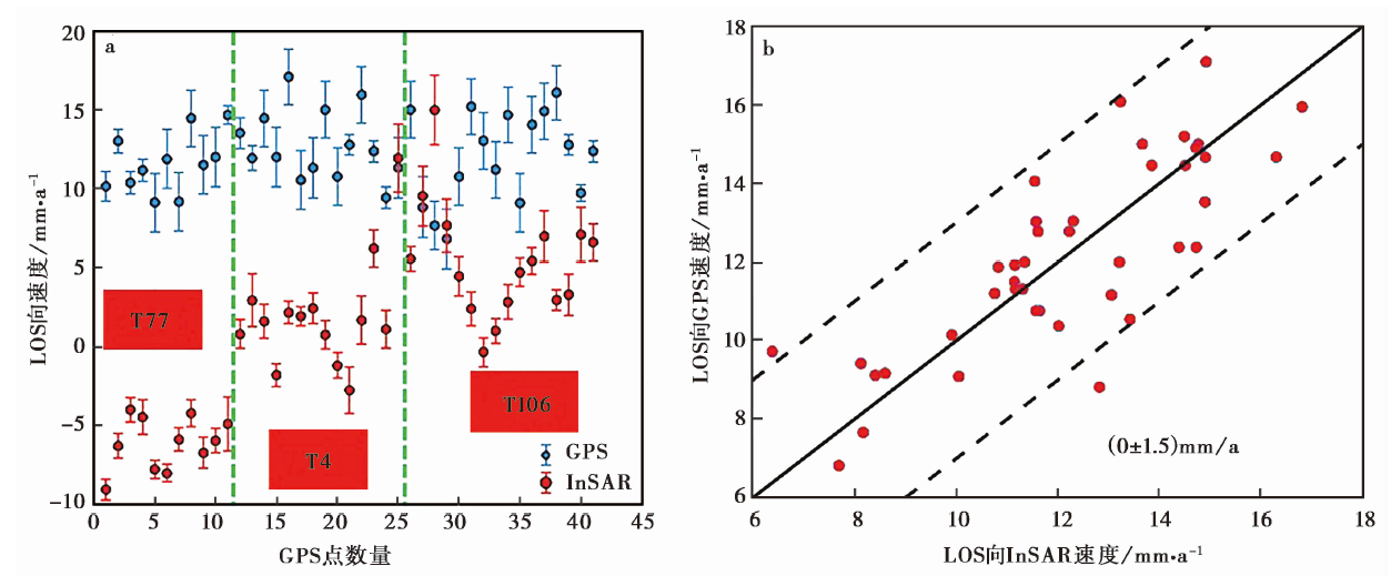
Fig. 8 Comparison of displacement rate of all GPS points to the InSAR displacement rate before and after correction.
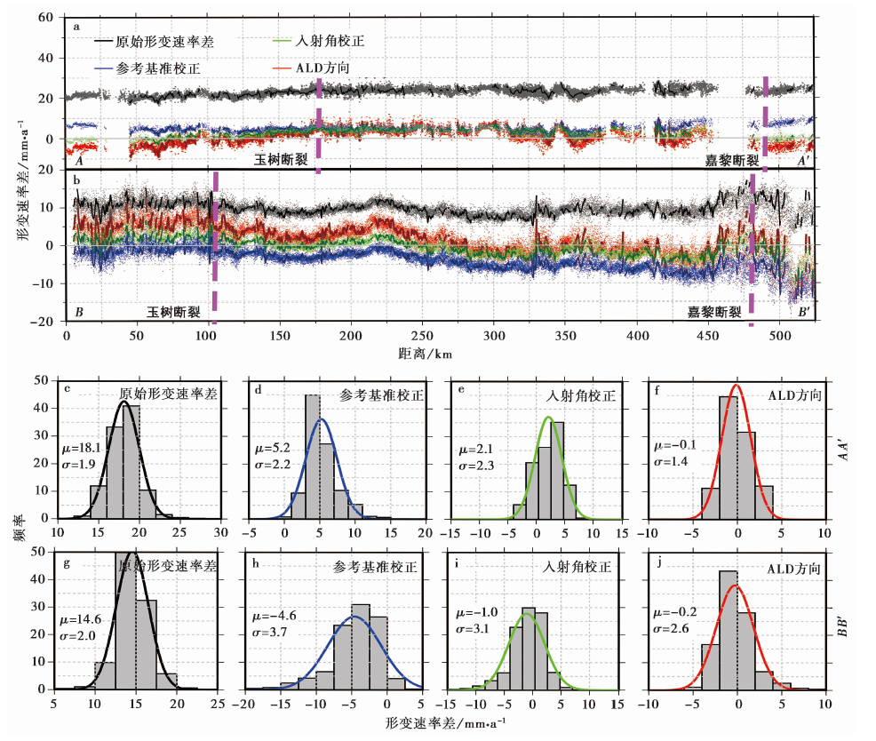
Fig. 10 Profiles of displacement rate difference between two adjacent tracks at AA' and BB'.
| [1] |
曹海坤. 2017. GPS、InSAR数据联合解算地表三维形变场[D]. 西安: 长安大学.
|
|
|
|
| [2] |
陈长云. 2014. 巴颜喀拉地块东部及其邻区块体运动及块体边界带形变特征[D]. 北京: 中国地震局地质研究所.
|
|
|
|
| [3] |
葛大庆. 2013. 区域性地面沉降InSAR监测关键技术研究[D]. 北京: 中国地质大学.
|
|
|
|
| [4] |
姜宇. 2017. InSAR大气校正技术研究及其在地震间形变监测中的应用[D]. 青岛: 中国石油大学(华东).
|
|
|
|
| [5] |
刘斌. 2013. InSAR高精度观测地震形变场及其三维重建技术研究[D]. 哈尔滨: 中国地震局工程力学研究所.
|
|
|
|
| [6] |
罗三明, 单新建, 朱文武, 等. 2014. 多轨PSInSAR监测华北平原地表垂直形变场[J]. 地球物理学报, 57(10): 3129-3139.
|
|
|
|
| [7] |
吕丽星, 李传友, 魏占玉, 等. 2017. 甘孜-玉树断裂带晚第四纪走滑速率与滑动分解作用[J]. 震灾防御技术, 12(3): 456-468.
|
|
|
|
| [8] |
孟国杰, 苏小宁, 徐婉桢, 等. 2016. 基于GPS观测研究2010年青海玉树 MS7.1 地震震后地壳形变特征及其机制[J]. 地球物理学报, 59(12): 4570-4583. doi: 10.6038/cjg20161219.
DOI |
|
|
|
| [9] |
宋小刚, 申星, 姜宇, 等. 2015. 通过InSAR与GPS数据融合获取汶川地震同震三维形变场[J]. 地震地质, 37(1): 222-231.
|
|
|
|
| [10] |
孙赫. 2015. 基于PS-InSAR技术的大范围多轨道数据地面沉降监测研究[D]. 西安: 长安大学.
|
|
|
|
| [11] |
唐方头, 宋键, 曹忠权, 等. 2010. 最新GPS数据揭示的东构造结周边主要断裂带的运动特征[J]. 地球物理学报, 53(9): 2119-2128.
|
|
|
|
| [12] |
王桂杰, 谢谟文, 邱骋, 等. 2010. D-InSAR技术在大范围滑坡监测中的应用[J]. 岩土力学, 31(4): 1337-1344.
|
|
|
|
| [13] |
王阎昭, 王敏, 沈正康, 等. 2011. 2010年玉树地震震前甘孜-玉树断裂形变场分析[J]. 地震地质, 33(3): 525-532. doi: 10.3969/j.issn.0523-4967.2011.03.003.
DOI |
|
|
|
| [14] |
闻学泽, 徐锡伟, 郑荣章, 等. 2003. 甘孜-玉树断裂的平均滑动速率与近代大地震破裂[J]. 中国科学(D辑), 33(S1): 199-208.
|
|
|
|
| [15] |
熊思婷, 曾琪明, 焦健, 等. 2014. 邻轨PS-InSAR地面沉降结果拼接处理方法与实验[J]. 地球信息科学学报, 16(5): 797-805. doi: 10.3724/sp.J.1047.2014.00797.
DOI |
|
|
|
| [16] |
徐小波. 2016. 多手段InSAR技术研究及其在同震、 震间形变监测中的应用[J]. 国际地震动态, 46(6): 34-36. doi: 10.3969/j.issn.0235-4975.2016.06.007.
DOI |
|
|
|
| [17] |
闫欢欢. 2017. 滇中主要断裂带地壳形变及断层运动特征的GPS研究[D]. 北京: 中国地震局地质研究所.
|
|
|
|
| [18] |
占文俊, 李志伟, 韦建超, 等. 2015. 一种InSAR大气相位建模与估计方法[J]. 地球物理学报, 58(7): 2320-2329.
|
|
|
|
| [19] |
张永红, 吴宏安, 康永辉. 2016. 京津冀地区1992-2014年三阶段地面沉降InSAR监测[J]. 测绘学报, 45(9): 1050-1058.
|
|
|
|
| [20] |
朱建军, 李志伟, 胡俊. 2017. InSAR变形监测方法与研究进展[J]. 测绘学报, 46(10): 1717-1733.
|
|
|
|
| [21] |
|
| [22] |
DOI URL |
| [23] |
|
| [24] |
|
| [25] |
DOI |
| [26] |
|
| [27] |
DOI URL |
| [28] |
|
| [29] |
DOI |
| [30] |
DOI URL |
| [31] |
DOI URL |
| [32] |
DOI URL |
| [33] |
DOI URL |
| [34] |
DOI URL |
| [35] |
DOI URL |
| [36] |
|
| [37] |
DOI URL |
| [38] |
DOI URL |
| [39] |
DOI |
| [40] |
DOI URL |
| [41] |
DOI |
| [42] |
DOI URL |
| [43] |
DOI |
| [44] |
DOI URL |
| [1] | JIANG Feng-yun, JI Ling-yun, ZHU Liang-yu, LIU Chuan-jin. THE PRESENT CRUSTAL DEFORMATION CHARACTERISTICS OF THE HAIYUAN-LIUPANSHAN FAULT ZONE FROM INSAR AND GPS OBSERVATIONS [J]. SEISMOLOGY AND GEOLOGY, 2023, 45(2): 377-400. |
| [2] | ZHANG Guo-qing, ZHU Yi-qing, LIANG Wei-feng. THE CRUSTAL DENSITY STRUCTURES AND ISOSTATIC ADDITIONAL STRESS AROUND THE FUBIANHE FAULT ON THE EASTERN MARGIN OF TIBET PLATEAU [J]. SEISMOLOGY AND GEOLOGY, 2022, 44(3): 578-589. |
| [3] | LIU Rui-chun, ZHANG Jin, GUO Wen-feng, CHEN Hui, ZHENG Ya-di, CHENG Cheng. STUDY ON THE RECENT DEFORMATION CHARACTERISTIC AND STRUCTURAL DEFORMATION MODEL OF THE SOUTH-EASTERN MARGIN OF ORDOS BLOCK [J]. SEISMOLOGY AND GEOLOGY, 2021, 43(3): 540-558. |
| [4] | DAI Cheng-long, ZHANG Ling, LIANG Shi-ming, ZHANG Ke-liang, XIONG Xiao-hui, GAN Wei-jun. PRESENT-DAY STRIKE-SLIP RATE AND ITS SEGMENTAL VARIATION OF THE TALAS-FERGHANA FAULT IN CENTRAL ASIA: INSIGHT FROM GPS GEODETIC OBSERVATIONS [J]. SEISMOLOGY AND GEOLOGY, 2021, 43(2): 263-279. |
| [5] | ZHU Shuang, LIANG Hong-bao, WEI Wen-xin, LI Jing-wei. SLIP RATES AND SEISMIC MOMENT DEFICITS ON MAJOR FAULTS IN THE TIANSHAN REGION [J]. SEISMOLOGY AND GEOLOGY, 2021, 43(1): 249-261. |
| [6] | TIAN Zhen, YANG Zhi-qiang, WANG Shi-di. MOMENT DEFICITS ON THE MAJOR FAULTS AND EARTHQUAKE HAZARD ASSESSMENT IN THE EASTERN HIMALAYAN SYNTAXIS [J]. SEISMOLOGY AND GEOLOGY, 2020, 42(1): 33-49. |
| [7] | CHEN Fu-chao, GUO Liang-qian, ZHENG Zhi-jiang. RESEARCH ON ACTIVITY OF ZHANGJIAKOU-BOHAI FAULT ZONE BASED ON GPS OBSERVATIONS [J]. SEISMOLOGY AND GEOLOGY, 2020, 42(1): 95-108. |
| [8] | WEI Cong-min, GE Wei-peng, ZHANG Bo. ESTIMATING THE LOWER CRUSTAL VISCOSITY OF THE WESTERN QINLING-SONGPAN TECTONIC NODE AND ITS ADJACENT AREAS BY USING LANDFORM MORPHOLOGY [J]. SEISMOLOGY AND GEOLOGY, 2020, 42(1): 163-181. |
| [9] | TANG Jing-tian, YANG Lei, REN Zheng-yong, HU Shuang-gui, XU Zhi-min. CHARACTERISTICS OF SATELLITE GRAVITY FIELD AND SEISMOGENIC MECHANISM IN THE LONGMENSHAN FAULT ZONE [J]. SEISMOLOGY AND GEOLOGY, 2019, 41(5): 1136-1154. |
| [10] | WEN Xiang, ZHOU Bin, SHI Shui-ping, QIN Jian, LI Jia-ning, HE Yan, YAN Chun-heng, LUO Yuan-peng. COMPREHENSIVE ANALYSIS OF RECENT GRAVITY AND CRUSTAL DEFORMATION IN NORTHWESTERN GUANGXI [J]. SEISMOLOGY AND GEOLOGY, 2019, 41(4): 927-943. |
| [11] | LIU Xiao-dong, SHAN Xin-jian, ZHANG Ying-feng, YIN Hao, QU Chun-yan. COSEISMIC DISPLACEMENT FIELD OF THE WENCHUAN EARTHQUAKE DERIVED FROM STRONG MOTION RECORDS AND APPLICATION IN SLIP INVERSION [J]. SEISMOLOGY AND GEOLOGY, 2019, 41(4): 1027-1041. |
| [12] | CHEN Yun-guo, HE Ping, DING Kai-hua, LI Shui-ping, WANG Qi. GEODETIC AND TELESEISMIC CONSTRAINTS ON SLIP DISTRIBUTION OF 2015 MW6.4 PISHAN EARTHQUAKE [J]. SEISMOLOGY AND GEOLOGY, 2019, 41(1): 137-149. |
| [13] | ZHU Yi-qing, LIANG Wei-feng, HAO Ming, ZHAO Ling-qiang, HAO Qing-hua, ZHANG Guo-qing, LIU Lian. THE COMPREHENSIVE ANALYSIS AND RESEARCH OF RECENT GRAVITY AND CRUSTAL DEFORMATION IN NORTHEASTERN EDGE OF THE TIBETAN PLATEAU [J]. SEISMOLOGY AND GEOLOGY, 2017, 39(4): 768-780. |
| [14] | HAO Ming, LI Yu-hang, QIN Shan-lan. SPATIAL AND TEMPORAL DISTRIBUTION OF SLIP RATE DEFICIT ACROSS HAIYUAN-LIUPAN SHAN FAULT ZONE CONSTRAINED BY GPS DATA [J]. SEISMOLOGY AND GEOLOGY, 2017, 39(3): 471-484. |
| [15] | CHANG Liu, YANG Bo, ZHANG Feng-shuang, XU Ming-yuan, YANG Guo-hua. GPS AND LEVELING CONSTRAINED CO-SEISMIC SOURCE AND SLIP DISTRIBUTION OF THE LUSHAN MS7.0 EARTHQUAKE ON 20 APRIL 2013 [J]. SEISMOLOGY AND GEOLOGY, 2017, 39(3): 561-571. |
| Viewed | ||||||
|
Full text |
|
|||||
|
Abstract |
|
|||||
