SEISMOLOGY AND GEOLOGY ›› 2023, Vol. 45 ›› Issue (2): 377-400.DOI: 10.3969/j.issn.0253-4967.2023.02.005
• Research paper • Previous Articles Next Articles
JIANG Feng-yun( ), JI Ling-yun, ZHU Liang-yu, LIU Chuan-jin
Revised:2023-02-10
Online:2023-04-20
Published:2023-05-18
蒋锋云(), 季灵运, 朱良玉, 刘传金
作者简介:蒋锋云,男,1978年生,高级工程师,主要从事地壳形变机理与地震长期预测研究,E-mail:jfy267862@163.com。
基金资助:CLC Number:
JIANG Feng-yun, JI Ling-yun, ZHU Liang-yu, LIU Chuan-jin. THE PRESENT CRUSTAL DEFORMATION CHARACTERISTICS OF THE HAIYUAN-LIUPANSHAN FAULT ZONE FROM INSAR AND GPS OBSERVATIONS[J]. SEISMOLOGY AND GEOLOGY, 2023, 45(2): 377-400.
蒋锋云, 季灵运, 朱良玉, 刘传金. 联合GPS和InSAR研究海原-六盘山断裂现今的地壳变形特征[J]. 地震地质, 2023, 45(2): 377-400.
Add to citation manager EndNote|Ris|BibTeX
URL: https://www.dzdz.ac.cn/EN/10.3969/j.issn.0253-4967.2023.02.005

Fig. 1 Dynamic environment, topography, main faults and earthquake epicentre(M≥6.0)in Haiyuan-Liupanshan tectonic region.
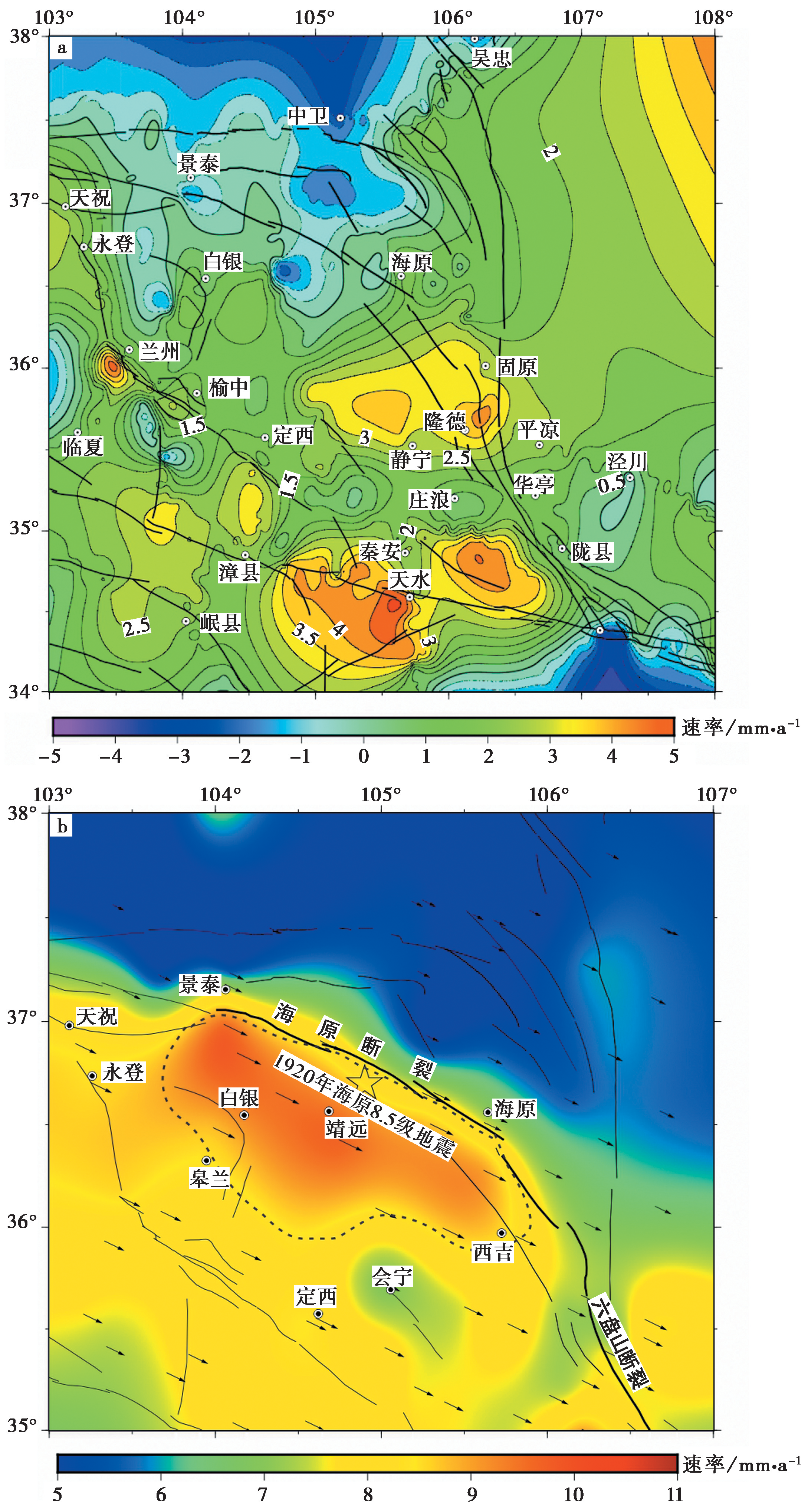
Fig. 2 GPS velocity field in Haiyuan-Liupanshan area.
| 轨道号 | 轨道方向 | 波长/cm | 轨道方位角/(°) | 影像数/景 | 参与计算影像数/景 | 干涉图数/幅 |
|---|---|---|---|---|---|---|
| 157 | 升轨 | 5.6 | -13 | 90 | 84 | 259 |
| 62 | 降轨 | 5.6 | 193 | 118 | 91 | 893 |
Table1 Sentinel Image Parameters in the study area
| 轨道号 | 轨道方向 | 波长/cm | 轨道方位角/(°) | 影像数/景 | 参与计算影像数/景 | 干涉图数/幅 |
|---|---|---|---|---|---|---|
| 157 | 升轨 | 5.6 | -13 | 90 | 84 | 259 |
| 62 | 降轨 | 5.6 | 193 | 118 | 91 | 893 |
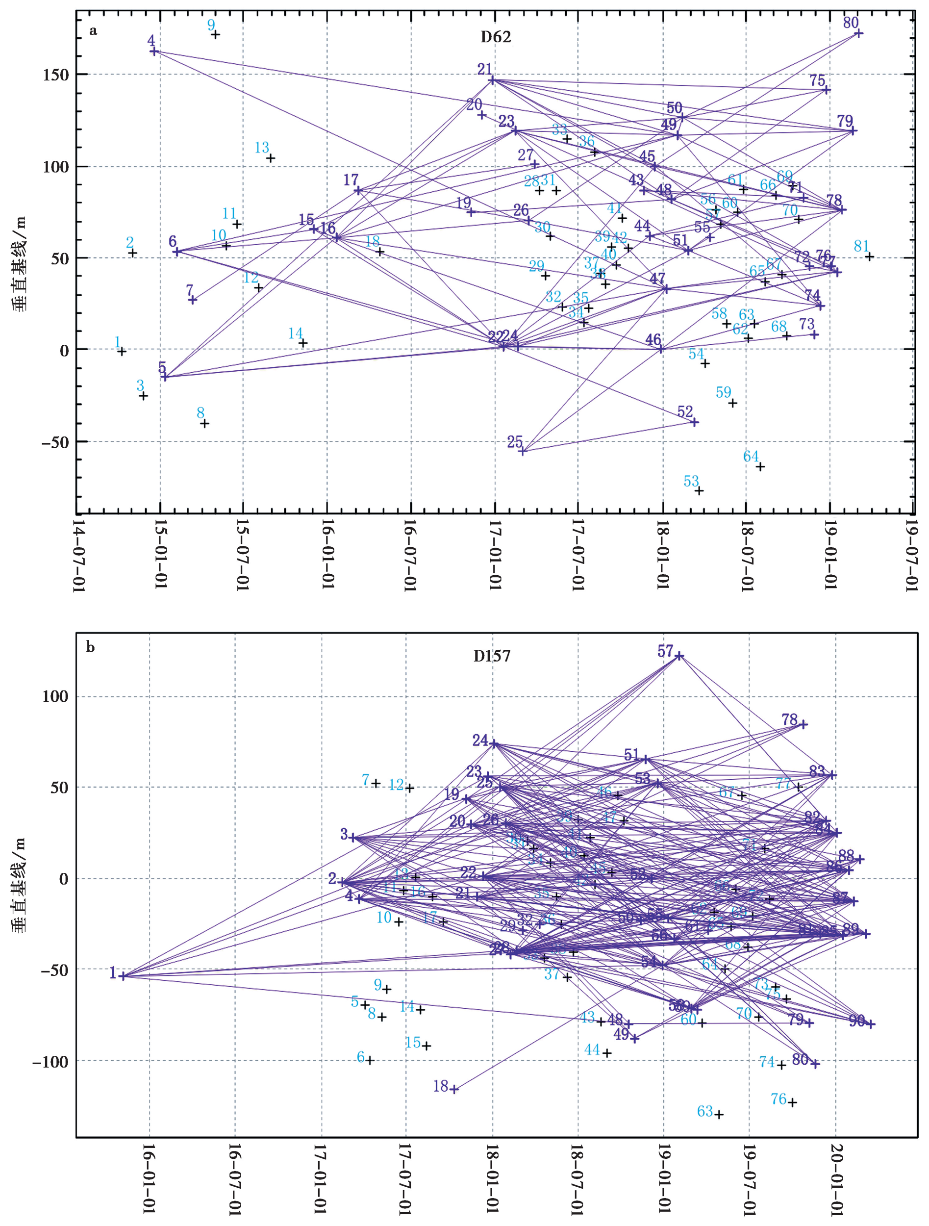
Fig. 3 Distribution of spatial-temporal baseline.

Fig. 4 InSAR deformation field of Haiyuan fault zone.
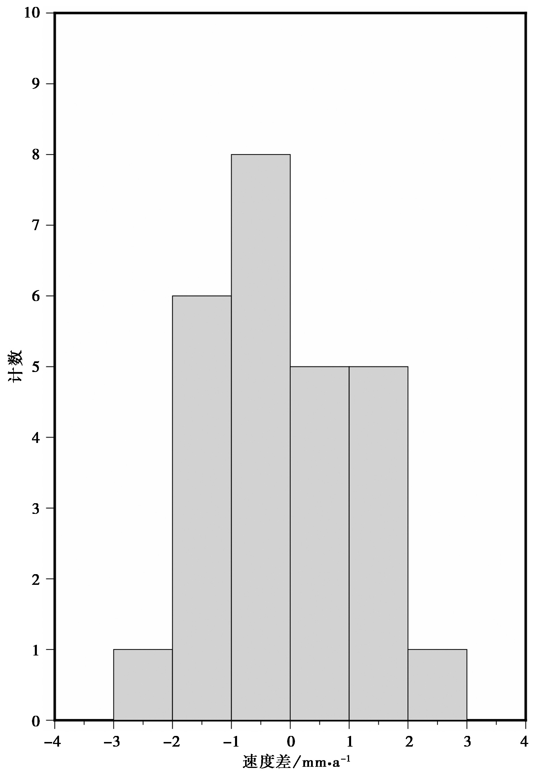
Fig. 5 Histogram of velocity differences between InSAR and projected GPS LOS data.

Fig. 6 Projection of parallel fault rates across the Haiyuan fault section.

Fig. 7 InSAR deformation rate in LOS direction of Liupanshan fault tectonic zone.
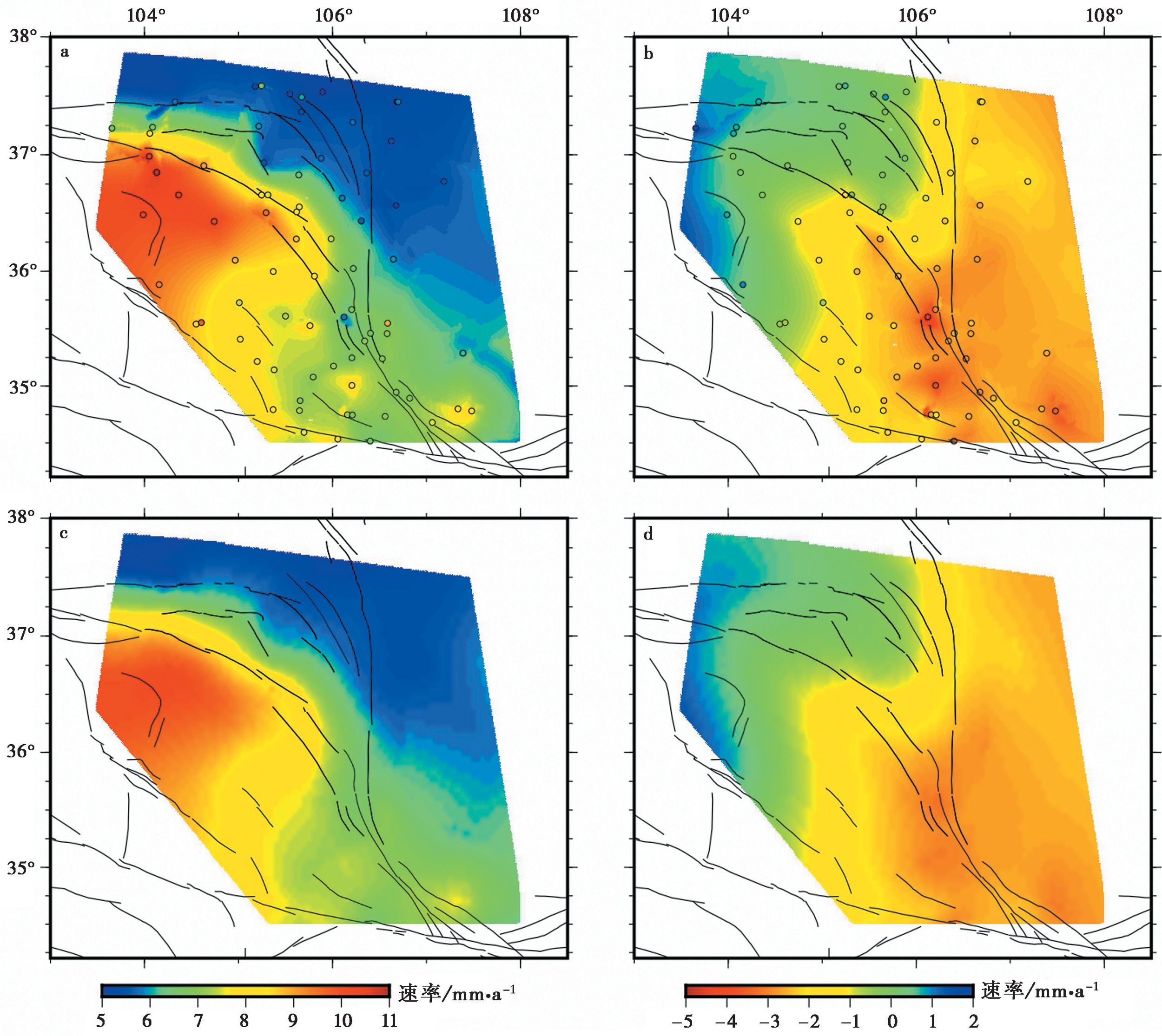
Fig. 8 V-east(a) and V-north(b) components of the InSAR-GPS integrated velocity field. V-east(c) and V-north(d) components interpolated only using GPS data.
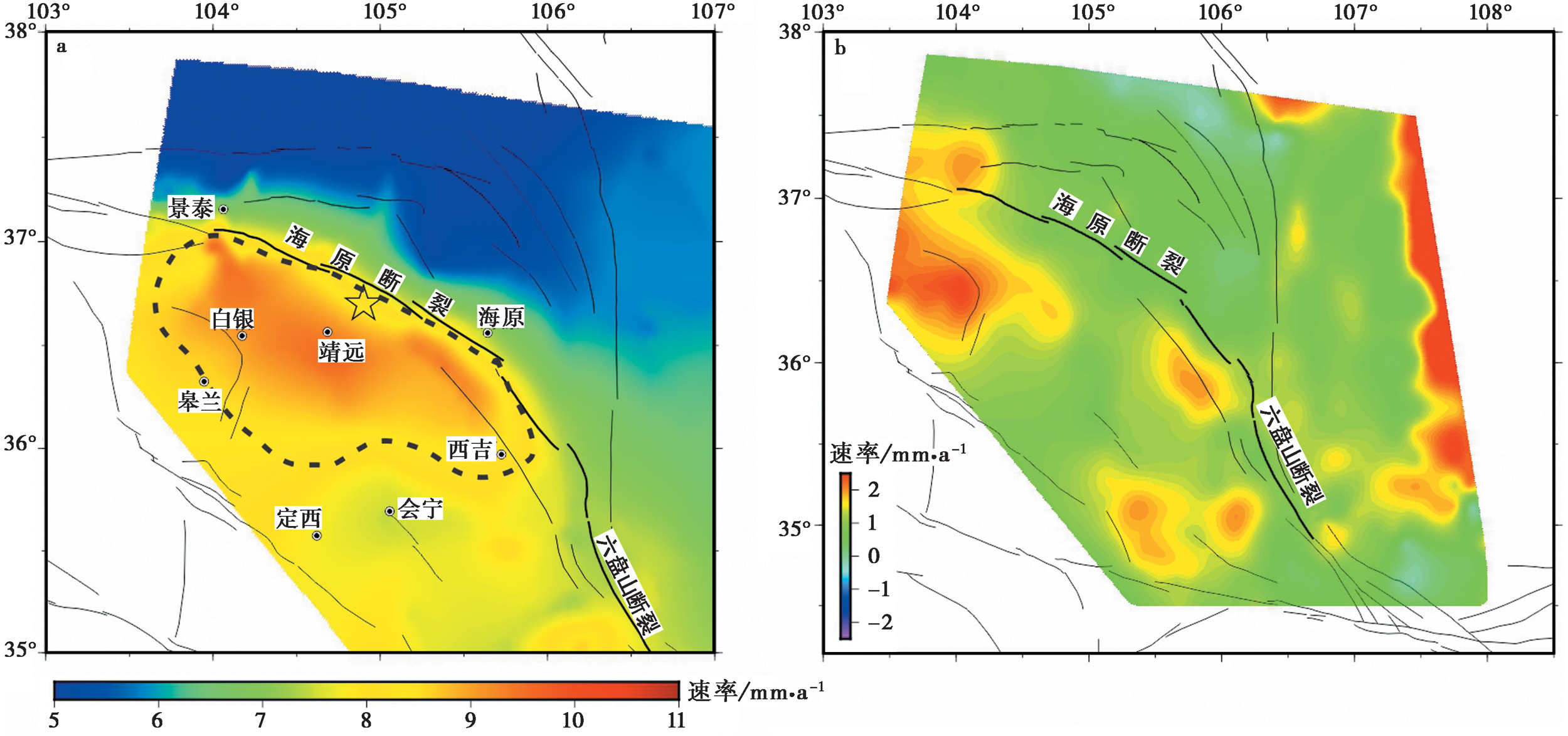
Fig. 9 InSAR-GPS integrated velocity filed.
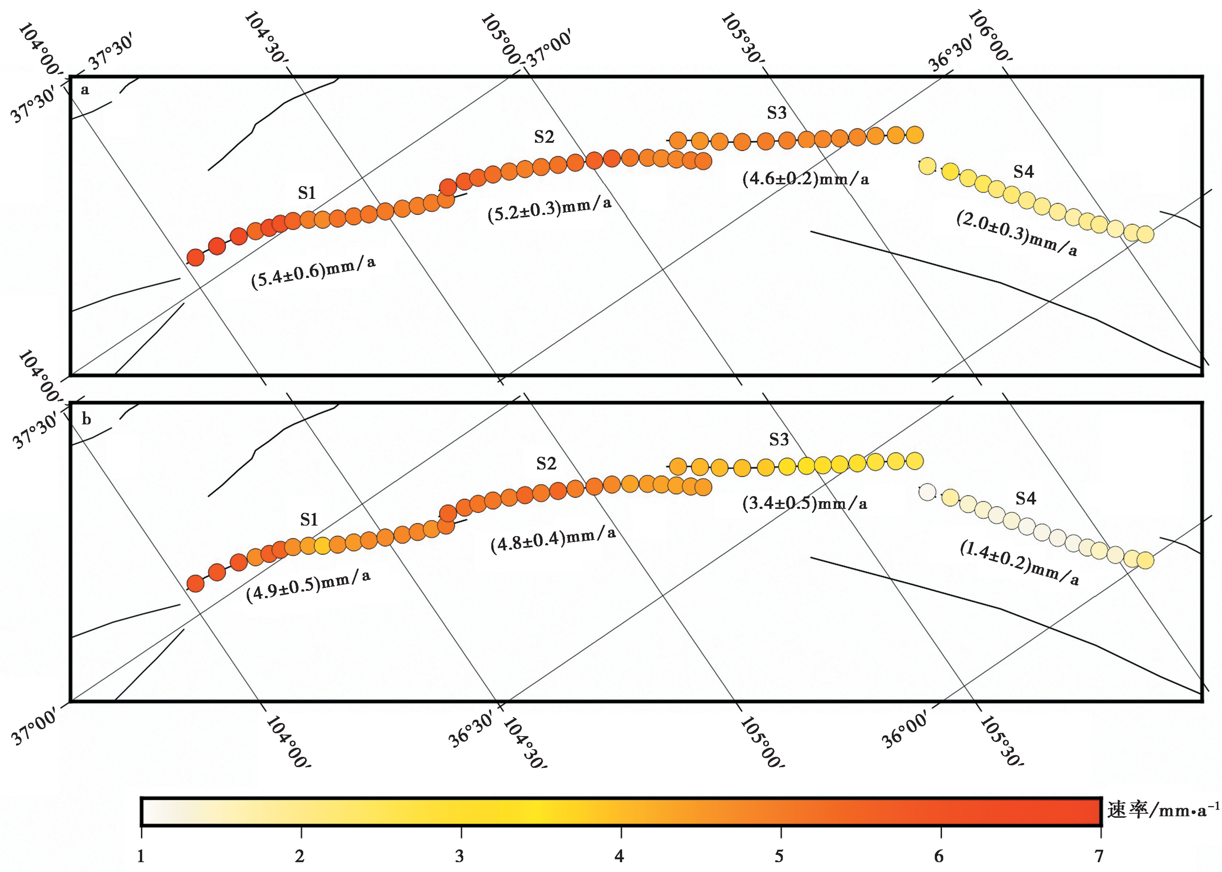
Fig. 10 Slip rate along the Haiyuan fault strike.
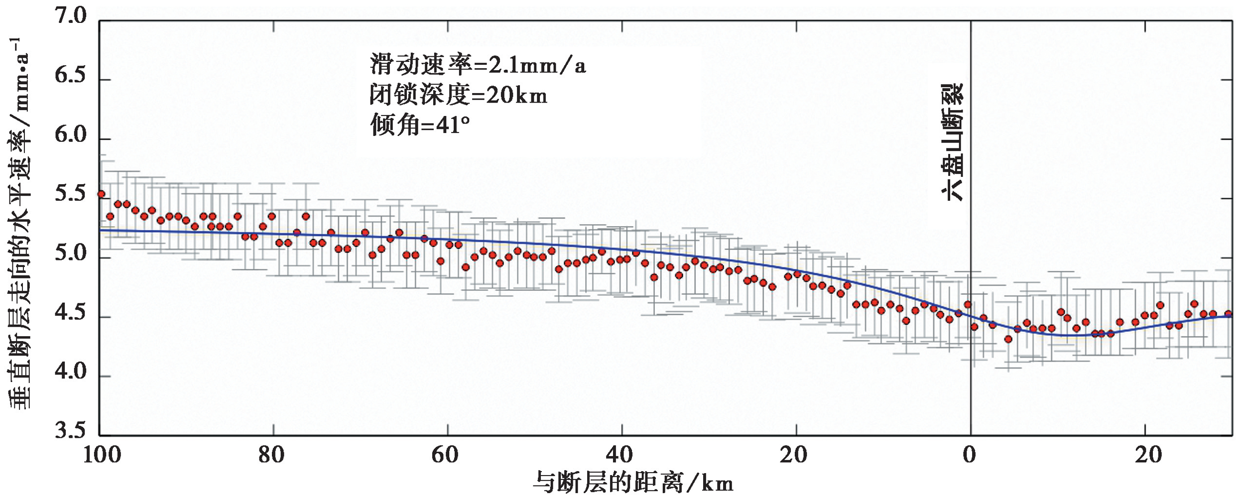
Fig. 11 Horizontal rate in the vertical fault direction crosses mid-south section of the Liupanshan fault(red dot) and the fitting curve using a two-dimensional screw dislocation model(blue line).

Fig. 12 Strain rate field in the study area.
| [1] | 崔笃信, 王庆良, 胡亚轩, 等. 2009. 用GPS数据反演海原断裂带断层滑动速率和闭锁深度[J]. 地震学报, 31(5): 516-525. |
| CUI Du-xin, WANG Qing-liang, HU Ya-xuan, et al. 2009. Inversion of GPS data for slip rates and locking depths of the Haiyuan fault[J]. Acta Seismologica Sinica, 31(5): 516-525. (in Chinese) | |
| [2] | 戴洪宝, 许继影. 2016. 海原断裂东段至六盘山断裂西段GPS剖面地壳变形与应变积累分析[J]. 大地测量与地球动力学, 36(4): 343-345. |
| DAI Hong-bao, XU Ji-ying. 2016. Analysis of the GPS section deformation and strain accumulation of the eastern Haiyuan and the western Liupanshan faults[J]. Journal of Geodesy and Geodynamics, 36(4): 343-345. (in Chinese) | |
| [3] | 邓起东, 程绍平, 闵伟, 等. 1999. 鄂尔多斯块体新生代构造活动和动力学的讨论[J]. 地质力学学报, 5(3): 13-21. |
| DENG Qi-dong, CHENG Shao-ping, MIN Wei, et al. 1999. Discussion on Cenozoic tectonics and dynamics of Ordos block[J]. Journal of Geomechanics, 5(3): 13-21. (in Chinese) | |
| [4] | 杜方, 闻学泽, 冯建刚, 等. 2018. 六盘山断裂带的地震构造特征与强震危险背景[J]. 地球物理学报, 61(2): 545-559. |
| DU Fang, WEN Xue-ze, FENG Jian-gang, et al. 2018. Seismo-tectonics and seismic potential of the Liupanshan fault zone(LPSFZ), China[J]. Chinese Journal of Geophys, 61(2): 545-559. (in Chinese) | |
| [5] | 胡亚轩, 崔笃信, 张希, 等. 2009. 用GPS数据反演分析海原断裂带分段活动特征[J]. 西北地震学报, 31(3): 227-253. |
| HU Ya-xuan, CUI Du-xin, ZHANG Xi, et al. 2009. Inversion and analysis of the active characteristics of subsections of Haiyuan fault belt using GPS data[J]. Northwestern Seismological Journal, 31(3): 227-253. (in Chinese) | |
| [6] | 蒋锋云, 王庆良, 朱良玉, 等. 2011. 汶川地震震前龙门山以西地壳垂直隆升机理分析[J]. 大地测量与地球动力学, 31(5): 26-29. |
| JIANG Feng-yun, WANG Qing-liang, ZHU Liang-yu, et al. 2011. Mechanism analysis of vertical uplift of crust in the west of Longmenshan before Wenchuan MS8.0 earthquake[J]. Journal of Geodesy and Geodynamics, 31(5): 26-29. (in Chinese) | |
| [7] | 蒋锋云, 朱良玉, 王双绪, 等. 2013. 青藏东北缘块体水平运动特征研究[J]. 大地测量与地球动力学, 33(2): 13-17. |
| JIANG Feng-yun, ZHU Liang-yu, WANG Shuang-xu, et al. 2013. Horizontal movement characteristics of northeastern margin of Qinghai-Tibet crustal blocks[J]. Journal of Geodesy and Geodynamics, 33(2): 13-17. (in Chinese) | |
| [8] | 江在森, 马宗晋, 张希, 等. 2003. GPS初步结果揭示的中国大陆水平应变场与构造变形[J]. 地球物理学报, 46(3): 352-358. |
| JIANG Zai-sen, MA Zong-jin, ZHANG Xi, et al. 2003. Horizontal strain field and tectonic deformation of China mainland revealed by preliminary GPS result[J]. Chinese Journal of Geophysics, 46(3): 352-358. (in Chinese) | |
| [9] | 李海兵, 戚学祥, 朱迎堂, 等. 2004. 2001年东昆仑地震(MS=8.1)不对称的同震地表破裂构造[J]. 地质学报, 78(5): 633-640. |
| LI Hai-bing, QI Xue-xiang, ZHU Ying-tang, et al. 2004. Asymmetrical co-seismic surface ruptures in the east Kunlun earthquake(MS=8.1), northern Tibetan plateau, China[J]. Acta Geologica Sinica, 78(5): 633-640. (in Chinese) | |
| [10] | 李强, 江在森, 武艳强, 等. 2014. 利用GPS资料反演海原-六盘山断裂带闭锁程度与滑动亏损分布[J]. 武汉大学学报(信息科学版), 39(5): 575-580. |
| LI Qiang, JIANG Zai-sen, WU Yan-qiang, et al. 2014. Inversion of locking and distribution of slip deficit in Haiyuan-Liupan fault zone using GPS data[J]. Geomatics and Information Science of Wuhan University, 39(5): 575-580. (in Chinese) | |
| [11] | 刘雷, 蒋锋云, 朱良玉. 2020. 南北地震带北段现今运动特征及地震活动性分析[J]. 地震研究, 43(4): 658-665. |
| LIU Lei, JIANG Feng-yun, ZHU Liang-yu. 2020. Characteristics of recent crustal movement and seismicity in the northern section of the North-South Seismic Belt[J]. Journal of Seismological Research, 43(4): 658-665. (in Chinese) | |
| [12] | 刘雷, 李玉江, 朱良玉, 等. 2021. 1947年达日M7.7地震对巴颜喀拉块体边界断裂应力影响的数值模拟[J]. 地球物理学报, 64(7): 2221-2231. |
| LIU Lei, LI Yu-jiang, ZHU Liang-yu, et al. 2021. Influence of the 1947 Dari M7.7 earthquake on stress evolution along the boundary fault of the Bayan Har block: insights from numerical simulation[J]. Chinese Journal of Geophysics, 64(7): 2221-2231. (in Chinese) | |
| [13] | 乔鑫, 屈春燕, 单新建, 等. 2019. 基于时序InSAR的海原断裂带形变特征及运动学参数反演[J]. 地震地质, 41(6): 1481-1496. |
| QIAO Xin, QU Chun-yan, SHAN Xin-jian, et al. 2019. Deformation characteristics and kinematic parameters inversion of Haiyuan fault zone based on time series InSAR[J]. Seismology and Geology, 41(6): 1481-1496. (in Chinese) | |
| [14] | 石富强, 邵志刚, 占伟, 等. 2018. 青藏高原东北缘活动断裂剪切模量及应力状态数值模拟[J]. 地球物理学报, 61(9): 3651-3663. |
| SHI Fu-qiang, SHAO Zhi-gang, ZHAN Wei, et al. 2018. Numerical modeling of the shear modulus and stress state of active faults in the northeastern margin of the Tibetan plateau[J]. Chinese Journal of Geophys, 61(9): 3651-3663. (in Chinese) | |
| [15] | 王庆良, 崔笃信, 张希, 等. 2010. 龙门山及汶川 MS8.0 地震垂直形变场研究[J]. 国际地震动态, (6): 11-12. |
| WANG Qing-liang, CUI Du-xin, ZHANG Xi, et al. 2010. Studies on surface vertical deformation of the Longmenshan and the Wenchuan MS8.0 earthquake[J]. Recent Developments in World Seismology, (6): 11-12. (in Chinese) | |
| [16] | 王伟涛, 张培震, 郑德文, 等. 2014. 青藏高原东北缘海原断裂带晚新生代构造变形[J]. 地学前缘, 21(4): 266-274. |
| WANG Wei-tao, ZHANG Pei-zhen, ZHENG De-wen, et al. 2014. Late Cenozoic tectonic deformation of the Haiyuan fault zone in the northeastern margin of the Tibetan plateau[J]. Earth Science Frontiers, 21(4): 266-274. (in Chinese) | |
| [17] | 吴东霖, 葛伟鹏, 魏聪敏. 2020. 利用Sentinel-1合成孔径雷达干涉测量技术监测海原断裂现今地壳变形特征[J]. 地震工程学报, 42(5): 1055-1064. |
| WU Dong-lin, GE Wei-peng, WEI Cong-min. 2020. Characteristics of present-day crustal deformation along the Haiyuan fault zone using PS-InSAR method[J]. China Earthquake Engineering Journal, 42(5): 1055-1064. (in Chinese) | |
| [18] | 武艳强, 江在森, 朱爽, 等. 2020. 中国大陆西部GNSS变形特征及其与M≥7.0强震孕育的关系[J]. 中国地震, 36(4): 756-766. |
| WU Yan-qiang, JIANG Zai-sen, ZHU Shuang, et al. 2020. GNSS deformation characteristics and its relationship with M≥7. 0 strong earthquakes in western China[J]. Earthquake Research in China, 36(4): 756-766. (in Chinese) | |
| [19] | 莘海亮, 曾宪伟, 康敏, 等. 2020. 海原弧形构造区地壳三维精细速度结构成像[J]. 地球物理学报, 63(3): 897-914. |
| XIN Hai-liang, ZENG Xian-wei, KANG Min, et al. 2020. Crustal fine velocity structure of the Haiyuan arcuate tectonic zone from double-difference tomography[J]. Chinese Journal of Geophys, 63(3): 897-914. (in Chinese) | |
| [20] | 张培震, 邓起东, 张国民, 等. 2003. 中国大陆的强震活动与活动地块[J]. 中国科学(D辑), 33(S1): 12-20. |
| ZHANG Pei-zhen, DENG Qi-dong, ZHANG Guo-min, et al. 2003. Strong earthquake activity and active blocks in Chinese Mainland[J]. Science in China(Ser D), 33(S1): 12-20. (in Chinese) | |
| [21] | 张晓亮, 师昭梦, 蒋锋云, 等. 2011. 海原-六盘山弧型断裂及其附近最新构造变形演化分析[J]. 大地测量与地球动力学, 31(3): 20-24. |
| ZHANG Xiao-liang, SHI Zhao-meng, JIANG Feng-yun, et al. 2011. Research on late tectonic deformation evolvement of Huaiyuan-Liupanshan arc fault and its surrounding area[J]. Journal of Geodesy and Geodynamics, 31(3): 20-24. (in Chinese) | |
| [22] | 郑文俊, 张培震, 袁道阳, 等. 2019. 中国大陆活动构造基本特征及其对区域动力过程的控制[J]. 地质力学学报, 25(5): 699-721. |
| ZHENG Wen-jun, ZHANG Pei-zhen, YUAN Dao-yang, et al. 2019. Basic characteristics of active tectonics and associated geodynamic processes in continental China[J]. Journal of Geomechanics, 25(5): 699-721. (in Chinese) | |
| [23] | 邹镇宇. 2015. 地表动态大地测量资料反映的孕震断层变形机制研究[D]. 北京: 中国地震局地质研究所:28-30. |
| ZOU Zhen-yu. 2015. Deformation mechanism of seismogenic faults derived from surface dynamic geodetic data[D]. Institute of Geology, China Earthquake Administration, Beijing: 28-30. (in Chinese) | |
| [24] | 邹镇宇, 江在森, 武艳强, 等. 2015. 针对一般倾角走滑/倾滑位移理论公式的改进[J]. 大地测量与地球动力学, 35(3): 460-468. |
| ZOU Zhen-yu, JIANG Zai-sen, WU Yan-qiang, et al. 2015. Improvements for the strike/dip-slip displacement theory formula of general dip fault[J]. Journal of Geodesy and Geodynamics, 35(3): 460-468. (in Chinese) | |
| [25] |
Devries P M R, Meade B J. 2013. Earthquake cycle deformation in the Tibetan plateau with a weak mid-crustal layer[J]. Journal of Geophysical Research: Solid Earth, 118(6): 3101-3111.
DOI URL |
| [26] |
Fuhrmann T, Caro Cuenca M, Knöpfler A, et al. 2015. Estimation of small surface displacements in the Upper Rhine Graben area from a combined analysis of PS-InSAR, levelling and GNSS data[J]. Geophysical Journal International, 203(1): 614-631.
DOI URL |
| [27] |
Gaudemer Y, Tapponnier P, Meyer B, et al. 1995. Partitioning of crustal slip between linked, active faults in the eastern Qilian Shan, and evidence for a major seismic gap, the 'Tianzhu gap', on the western Haiyuan Fault, Gansu(China)[J]. Geophysical Journal International, 120(3): 599-645.
DOI URL |
| [28] |
Goldstein R M, Werner C L. 1998. Radar interferogram filtering for geophysical applications[J]. Geophysical Research Letters, 25(21): 4035-4038.
DOI URL |
| [29] | Gudmundsson S, Sigmundsson F, Carstensen J M. 2002. Three-dimensional surface motion maps estimated from combined interferometric synthetic aperture radar and GPS data[J]. Journal of Geophysical Research: Solid Earth, 107(B10): 2250. |
| [30] |
Guglielmino F, Nunnari G, Puglisi G, et al. 2011. Simultaneous and integrated strain tensor estimation from geodetic and satellite deformation measurements to obtain three-dimensional displacement maps[J]. IEEE Transactions on Geoscience and Remote Sensing, 49(6): 1815-1826.
DOI URL |
| [31] |
Hao M, Wang Q L, Shen Z K, et al. 2014. Present day crustal vertical movement inferred from precise leveling data in eastern margin of Tibetan plateau[J]. Tectonophysics, 632: 281-292.
DOI URL |
| [32] |
Hergert T, Heidbach O. 2010. Slip-rate variability and distributed deformation in the Marmara Sea fault system[J]. Nature Geoscience, 3(2): 132-135.
DOI |
| [33] |
Hu J, Li Z W, Sun Q, et al. 2012. Three-dimensional surface displacements from InSAR and GPS measurements with variance component estimation[J]. IEEE Geoscience and Remote Sensing Letters, 9(4): 754-758.
DOI URL |
| [34] | Jiang F Y, Ji L Y, Zhu L Y. 2020. 3D viscoelastic finite element study of post-seismic influence of the Wenchuan earthquake in the Sichuan-Yunnan region[J]. Pure and Applied Geophysics, 177: 50-70. |
| [35] | Jolivet R, Lasserre C, Doin M P, et al. 2012. Shallow creep on the Haiyuan Fault(Gansu, China)revealed by SAR Interferometry[J]. Journal of Geophysical Research, 117(B6): B06401. |
| [36] | Li Y C, Nocquet J M, Shan X J, et al. 2021. Geodetic observations of shallow creep on the Laohushan-Haiyuan Fault, northeastern Tibet[J]. Journal of Geophysical Research: Solid Earth, 126(6): e2020JB021576. |
| [37] |
Liang S M, Gan W J, Shen C Z, et al. 2013. Three-dimensional velocity field of present-day crustal motion of the Tibetan plateau derived from GPS measurements[J]. Journal of Geophysical Research: Solid Earth, 118(10): 5722-5732.
DOI URL |
| [38] |
Lorenzo-Martín F, Roth F, Wang R J. 2006. Inversion for rheological parameters from post-seismic surface deformation associated with the 1960 Valdivia earthquake, Chile[J]. Geophysical Journal International, 164(1): 75-87.
DOI URL |
| [39] |
Luo H P, Liu Y, Chen T, et al. 2016. Derivation of 3-D surface deformation from an integration of InSAR and GNSS measurements based on Akaike’s Bayesian Information Criterion[J]. Geophysical Journal International, 204(1): 292-310.
DOI URL |
| [40] | Lyons S, Sandwell D. 2003. Fault creep along the southern San Andreas from interferometric synthetic aperture radar, permanent scatterers, and stacking[J]. Journal of Geophysical Research: Solid Earth, 108(B1): ETG11-1-ETG11-24. |
| [41] |
Rice J R, Gu J C. 1983. Earthquake aftereffects and triggered seismic phenomena[J]. Pure and Applied Geophysics, 121(2): 187-219.
DOI URL |
| [42] |
Samsonov S, Tiampo K, Rundle J, et al. 2007. Application of DInSAR-GPS optimization for derivation of fine-scale surface motion maps of southern California[J]. IEEE Transactions on Geoscience and Remote Sensing, 45(2): 512-521.
DOI URL |
| [43] |
Savage J C. 2000. Viscoelastic coupling model for the earthquake cycle driven from below[J]. Journal of Geophysical Research, 105(B11): 25525-25532.
DOI URL |
| [44] |
Savage J C, Burford R O. 1973. Geodetic determination of relative plate motion in central California[J]. Journal of Geophysical Research, 78(5): 832-845.
DOI URL |
| [45] | Shen Z K, Liu Z. 2020. Integration of GPS and InSAR data for resolving 3-dimensional crustal deformation[J]. Earth and Space Science, 7(4): e2019EA001036. |
| [46] | Shen Z K, Wang M, Zeng Y H, et al. 2015. Optimal interpolation of spatially discretized geodetic data[J]. Bulletin of the Seismological Society of America, 105(4): 2117-2127. |
| [47] |
Song X G, Jiang Y, Shan X J, et al. 2019. A fine velocity and strain rate field of present-day crustal motion of the northeastern Tibetan plateau inverted jointly by InSAR and GPS[J]. Remote Sensing, 11(4): 435.
DOI URL |
| [48] |
Walters R J, Parsons B, Wright T J. 2014. Constraining crustal velocity fields with InSAR for Eastern Turkey: Limits to the block-like behavior of Eastern Anatolia[J]. Journal of Geophysical Research: Solid Earth, 119(6): 5215-5234.
DOI URL |
| [49] |
Wang H, Wright T J, Liu-Zeng J, et al. 2019. Strain rate distribution in south-central Tibet from two decades of InSAR and GPS[J]. Geophysical Research Letters, 46(10): 5170-5179.
DOI |
| [50] | Wang M, Shen Z K. 2020. Present-day crustal deformation of continental China derived from GPS and its tectonic implications[J]. Journal of Geophysical Research: Solid Earth, 125(2): e2019JB018774. |
| [51] |
Yagüe-Martínez N, Prats-Iraola P, Rodriguez-Gonzalez F, et al. 2016. Interferometric processing of Sentinel-1 TOPS data[J]. IEEE Transactions on Geoscience and Remote Sensing, 54(4): 2220-2234.
DOI URL |
| [52] |
Yu C, Li Z H, Penna N T. 2018. Interferometric synthetic aperture radar atmospheric correction using a GPS-based iterative tropospheric decomposition model[J]. Remote Sensing of Environment, 24: 109-121.
DOI URL |
| [53] |
Zhang P Z, Burchfiel B C, Molnar P, et al. 1990. Late Cenozoic tectonic evolution of the Ningxia-Hui Autonomous region, China[J]. Geological Society of America Bulletin, 102(11): 1484-1498.
DOI URL |
| [54] |
Zhang W T, Ji L Y, Zhu L Y, et al. 2022. Current slip and strain rate distribution along the Ganzi-Yushu-Xianshuihe fault system based on InSAR and GPS observations[J]. Frontiers in Earth Science, 10: 821761.
DOI URL |
| [1] | ZHAO De-zheng, QU Chun-yan, ZHANG Gui-fang, GONG Wen-yu, SHAN Xin-jian, ZHU Chuan-hua, ZHANG Guo-hong, SONG Xiao-gang. APPLICATIONS AND ADVANCES FOR THE COSEISMIC DEFORMA-TION OBSERVATIONS, EARTHQUAKE EMERGENCY RESPONSE AND SEISMOGENIC STRUCTURE INVESTIGATION USING INSAR [J]. SEISMOLOGY AND GEOLOGY, 2023, 45(2): 570-592. |
| [2] | JIN Li-zhou, WANG Ying, CHANG Wen-bin, TIAN Ying-ying, YUAN Ren-mao. STABILITY ANALYSIS OF THE BAIGE LANDSLIDE USING D-INSAR AND PFC2D MODELING [J]. SEISMOLOGY AND GEOLOGY, 2023, 45(1): 153-171. |
| [3] | YU Shu-yuan, HUANG Xian-liang, ZHENG Hai-gang, LI Ling-li, LUO Jia-ji, DING Juan, FAN Xiao-ran. THE COSEISMIC RUPTURE MODEL AND STRESS CHANGE OF THE 2022 MENYUAN MW6.7 EARTHQUAKE [J]. SEISMOLOGY AND GEOLOGY, 2023, 45(1): 286-303. |
| [4] | HUA Jun, GONG Wen-yu, SHAN Xin-jian, WANG Zhen-jie, JI Ling-yun, LIU Chuan-jin, LI Yong-sheng. RESEARCH ON INTEGRATING INTERSEISMIC DEFORMATION RATE FIELDS OF MULTI-TRACK INSAR [J]. SEISMOLOGY AND GEOLOGY, 2022, 44(5): 1172-1189. |
| [5] | YU Shu-yuan, ZHANG Guo-hong, ZHANG Ying-feng, DING Juan, ZHANG Jian-long, FAN Xiao-ran, WANG Shao-jun. COSEISMIC SLIP DISTRIBUTION OF THE 2021 MW5.8 BIRU(TIBET, CHINA)EARTHQUAKE AND THE COULOMB STRESS VARIATION [J]. SEISMOLOGY AND GEOLOGY, 2022, 44(5): 1190-1202. |
| [6] | ZHANG Guo-qing, ZHU Yi-qing, LIANG Wei-feng. THE CRUSTAL DENSITY STRUCTURES AND ISOSTATIC ADDITIONAL STRESS AROUND THE FUBIANHE FAULT ON THE EASTERN MARGIN OF TIBET PLATEAU [J]. SEISMOLOGY AND GEOLOGY, 2022, 44(3): 578-589. |
| [7] | WANG Yu-qing, FENG Wan-peng, ZHANG Pei-zhen. PRESENT DEFORMATION OF~90° INTERSECTING CONJUGATE FAULTS AND MECHANICAL IMPLICATION TO REGIONAL TECTONICS: A CASE STUDY OF 2019 MW≥6.4 PHILIPPINES EARTHQUAKE SEQUENCE [J]. SEISMOLOGY AND GEOLOGY, 2022, 44(2): 313-332. |
| [8] | XU Fang, LU Ren-qi, WANG Shuai, JIANG Guo-yan, LONG Feng, WANG Xiao-shan, SU Peng, LIU Guan-shen. STUDY ON THE SEISMOTECTONICS OF THE QINGBAIJIANG MS5.1 EARTHQUAKE IN SICHUAN PROVINCE IN 2020 BY MULTIPLE CONSTRAINT METHOD [J]. SEISMOLOGY AND EGOLOGY, 2022, 44(1): 220-237. |
| [9] | QIU Jiang-tao, JI Ling-yun, LIU lei, LIU Chuan-jin. INSAR COSEISMIC DEFORMATION AND TECTONIC IMPLICATIONS FOR THE 2020 MW6.3 NIMA EARTHQUAKE IN XIZANG [J]. SEISMOLOGY AND EGOLOGY, 2021, 43(6): 1586-1599. |
| [10] | XU Xiao-xue, JI Ling-yun, ZHU Liang-yu, WANG Guang-ming, ZHANG Wen-ting, LI Ning. THE CO-SEISMIC DEFORMATION CHARACTERISTICS AND SEISMOGENIC STRUCTURE OF THE YANGBI MS6.4 EARTHQUAKE [J]. SEISMOLOGY AND EGOLOGY, 2021, 43(4): 771-789. |
| [11] | LIU Rui-chun, ZHANG Jin, GUO Wen-feng, CHEN Hui, ZHENG Ya-di, CHENG Cheng. STUDY ON THE RECENT DEFORMATION CHARACTERISTIC AND STRUCTURAL DEFORMATION MODEL OF THE SOUTH-EASTERN MARGIN OF ORDOS BLOCK [J]. SEISMOLOGY AND GEOLOGY, 2021, 43(3): 540-558. |
| [12] | HUA Jun, ZHAO De-zheng, SHAN Xin-jian, QU Chun-yan, ZHANG Ying-feng, GONG Wen-yu, WANG Zhen-jie, LI Cheng-long, LI Yan-chuan, ZHAO Lei, CHEN Han, FAN Xiao-ran, WANG Shao-jun. COSEISMIC DEFORMATION FIELD, SLIP DISTRIBUTION AND COULOMB STRESS DISTURBANCE OF THE 2021 MW7.3 MADUO EARTHQUAKE USING SENTINEL-1 INSAR OBSERVATIONS [J]. SEISMOLOGY AND GEOLOGY, 2021, 43(3): 677-691. |
| [13] | DAI Cheng-long, ZHANG Ling, LIANG Shi-ming, ZHANG Ke-liang, XIONG Xiao-hui, GAN Wei-jun. PRESENT-DAY STRIKE-SLIP RATE AND ITS SEGMENTAL VARIATION OF THE TALAS-FERGHANA FAULT IN CENTRAL ASIA: INSIGHT FROM GPS GEODETIC OBSERVATIONS [J]. SEISMOLOGY AND GEOLOGY, 2021, 43(2): 263-279. |
| [14] | ZHANG Ying-feng, SHAN Xin-jian, ZHANG Guo-hong, LI Cheng-long, WEN Shao-yan, XIE Quan-cai. THE DEFORMATION OF 2020 MW6.0 KALPINTAGE EARTHQUAKE AND ITS IMPLICATION FOR THE REGIONAL RISK ESTIMATES [J]. SEISMOLOGY AND GEOLOGY, 2021, 43(2): 377-393. |
| [15] | ZHANG Wen-ting, JI Ling-yun, ZHU Liang-yu, JIANG Feng-yun, XU Xiao-xue. A TYPICAL THRUST RUPTURE EVENT OCCURRING IN THE FORELAND BASIN OF THE SOUTHERN TIANSHAN: THE 2020 XINJIANG JIASHI MS6.4 EARTHQUAKE [J]. SEISMOLOGY AND GEOLOGY, 2021, 43(2): 394-409. |
| Viewed | ||||||
|
Full text |
|
|||||
|
Abstract |
|
|||||
