SEISMOLOGY AND GEOLOGY ›› 2022, Vol. 44 ›› Issue (5): 1190-1202.DOI: 10.3969/j.issn.0253-4967.2022.05.007
• Research paper • Previous Articles Next Articles
YU Shu-yuan1),2)( ), ZHANG Guo-hong3)(), ZHANG Ying-feng3), DING Juan1),2), ZHANG Jian-long4), FAN Xiao-ran3),5), WANG Shao-jun3),5)
Received:2021-07-30
Revised:2022-01-04
Online:2022-10-20
Published:2022-11-28
Contact:
ZHANG Guo-hong
于书媛1),2)(), 张国宏3),*(), 张迎峰3), 丁娟1),2), 张建龙4), 范晓冉3),5), 王绍俊3),5)
通讯作者:
张国宏
作者简介:于书媛, 女, 1984年生, 2011年于中国矿业大学获地图学与地理信息系统专业硕士学位, 工程师, 主要研究方向为InSAR技术在地震及地壳形变观测中的应用, 电话: 18855171484, E-mail: 819718728@qq.com。
基金资助:YU Shu-yuan, ZHANG Guo-hong, ZHANG Ying-feng, DING Juan, ZHANG Jian-long, FAN Xiao-ran, WANG Shao-jun. COSEISMIC SLIP DISTRIBUTION OF THE 2021 MW5.8 BIRU(TIBET, CHINA)EARTHQUAKE AND THE COULOMB STRESS VARIATION[J]. SEISMOLOGY AND GEOLOGY, 2022, 44(5): 1190-1202.
于书媛, 张国宏, 张迎峰, 丁娟, 张建龙, 范晓冉, 王绍俊. InSAR数据约束的2021年西藏比如MW5.8地震同震滑动分布及库仑应力变化[J]. 地震地质, 2022, 44(5): 1190-1202.
Add to citation manager EndNote|Ris|BibTeX
URL: https://www.dzdz.ac.cn/EN/10.3969/j.issn.0253-4967.2022.05.007
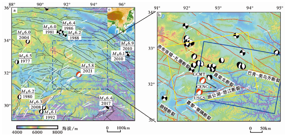
Fig. 1 Tectonic setting of the Biru region.
| 来源 | 北纬 /(°) | 东经 /(°) | 深度 /km | 节面Ⅰ/(°) | 节面Ⅱ/(°) | 震级 /MW | ||||
|---|---|---|---|---|---|---|---|---|---|---|
| 走向 | 倾角 | 滑动角 | 走向 | 倾角 | 滑动角 | |||||
| GCMT | 31.84 | 92.92 | 19.4 | 353 | 50 | -144 | 238 | 63 | -47 | 5.8 |
| USGS | 31.925 | 92.915 | 11.5 | 17 | 37 | -113 | 225 | 56 | -74 | 5.7 |
Table1 Focal parameters of the MW5.8 earthquake in Biru from different agencies
| 来源 | 北纬 /(°) | 东经 /(°) | 深度 /km | 节面Ⅰ/(°) | 节面Ⅱ/(°) | 震级 /MW | ||||
|---|---|---|---|---|---|---|---|---|---|---|
| 走向 | 倾角 | 滑动角 | 走向 | 倾角 | 滑动角 | |||||
| GCMT | 31.84 | 92.92 | 19.4 | 353 | 50 | -144 | 238 | 63 | -47 | 5.8 |
| USGS | 31.925 | 92.915 | 11.5 | 17 | 37 | -113 | 225 | 56 | -74 | 5.7 |
| 轨道方向 (轨道号) | 成像日期 | 极化 方式 | 视线方位角α /(°) | 视线入射角θ /(°) | 空间基线 /m | 时间基线 /d | |
|---|---|---|---|---|---|---|---|
| 震前 | 震后 | ||||||
| 升轨(T143) | 2021-03-12 | 2021-03-24 | VV | -12.812 | 34.474 | -25.386 | 12 |
| 降轨(T77) | 2021-03-07 | 2021-03-19 | VV | -167.195 | 34.509 | -42.929 | 12 |
Table2 Parameters of ascending and descending scenes
| 轨道方向 (轨道号) | 成像日期 | 极化 方式 | 视线方位角α /(°) | 视线入射角θ /(°) | 空间基线 /m | 时间基线 /d | |
|---|---|---|---|---|---|---|---|
| 震前 | 震后 | ||||||
| 升轨(T143) | 2021-03-12 | 2021-03-24 | VV | -12.812 | 34.474 | -25.386 | 12 |
| 降轨(T77) | 2021-03-07 | 2021-03-19 | VV | -167.195 | 34.509 | -42.929 | 12 |
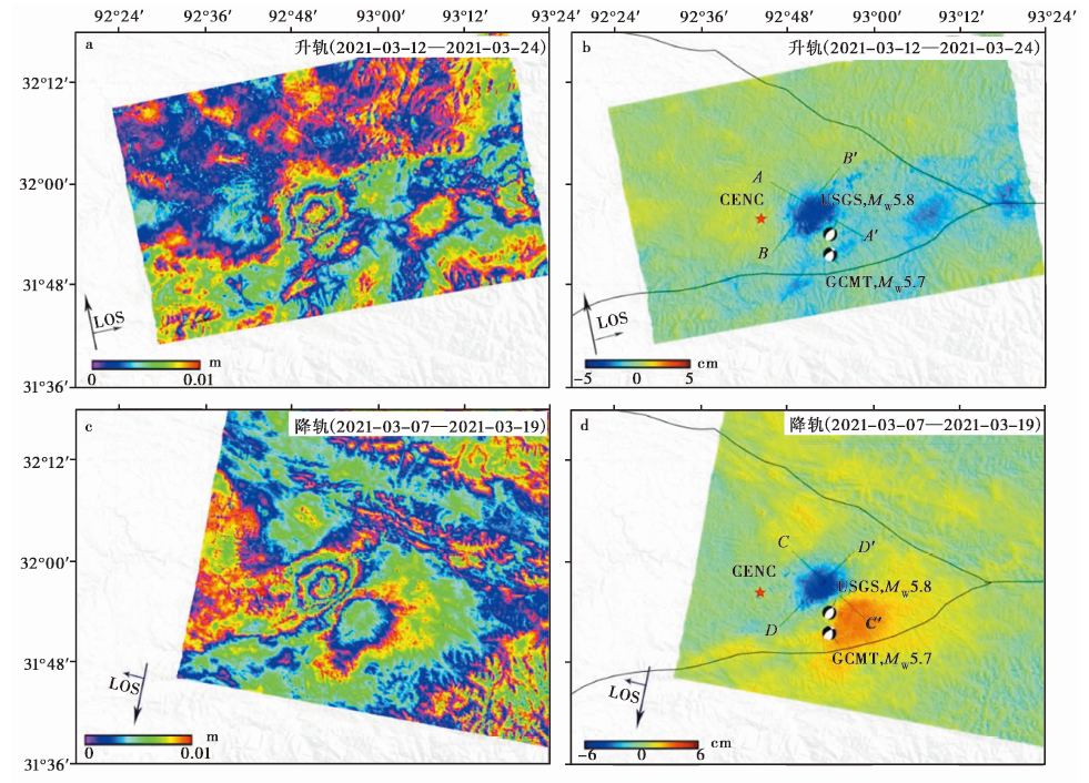
图2 Coseismic deformation field and coseismic displacement field(The LOS near the satellite is positive).
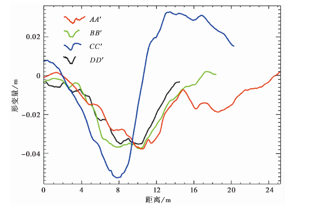
图3 The line of sight(LOS)displacement profile of different observation modes of the 2021 Biru earthquake.
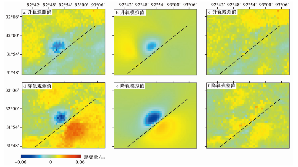
Fig. 4 Observation, model value and residual value of InSAR (The dotted line is the fault strike obtained by inversion).
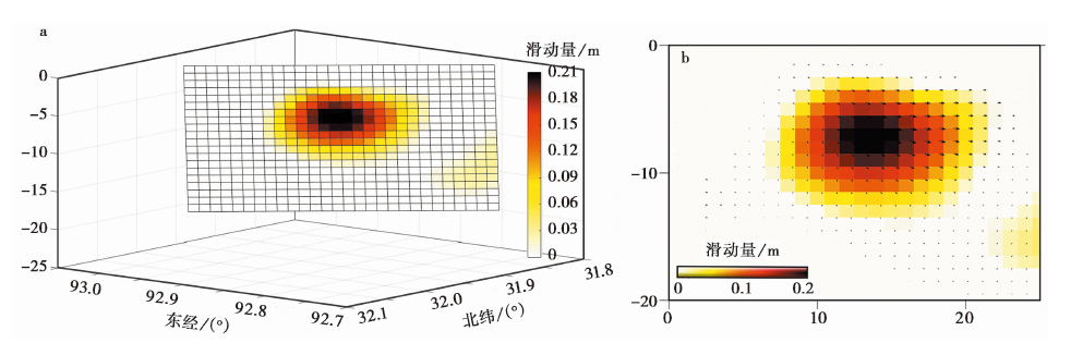
Fig. 5 Coseismic slip distribution of northwest-dipping rupture model in Biru earthquake.
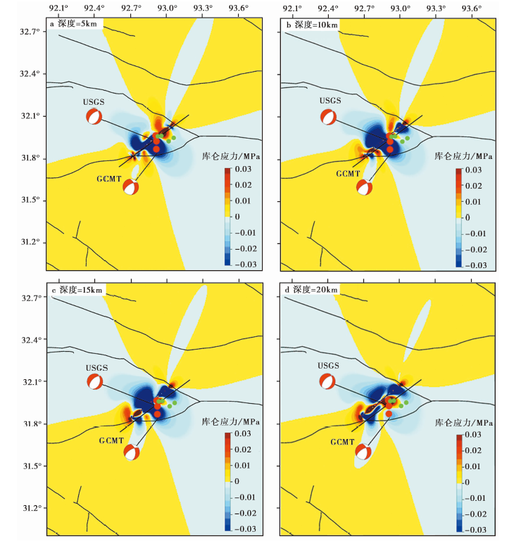
Fig. 6 Variation diagram of coseismic Coulomb rupture stress of seismogenic faults at different depths.
| 序号 | 时间(UTC) | 东经/(°) | 北纬/(°) | 深度/km | 震级/MW |
|---|---|---|---|---|---|
| 1 | 2021-05-17 T04:37:25 | 92.926 | 31.960 | 10 | 4.3 |
| 2 | 2021-04-06 T22:00:59 | 93.059 | 31.949 | 10 | 4.3 |
| 3 | 2021-04-06 T21:55:47 | 92.956 | 31.963 | 10 | 4.7 |
| 4 | 2021-04-06 T21:48:35 | 92.914 | 31.869 | 10 | 5.0 |
| 5 | 2021-03-22 T17:23:35 | 92.908 | 31.966 | 10 | 5.0 |
| 6 | 2021-03-19 T18:04:10 | 93.017 | 31.925 | 10 | 4.3 |
| 7 | 2021-03-19 T06:11:27 | 92.915 | 31.925 | 8 | 5.7 |
Table3 Earthquakes in the study area from March 19, 2021 to July 15, 2021
| 序号 | 时间(UTC) | 东经/(°) | 北纬/(°) | 深度/km | 震级/MW |
|---|---|---|---|---|---|
| 1 | 2021-05-17 T04:37:25 | 92.926 | 31.960 | 10 | 4.3 |
| 2 | 2021-04-06 T22:00:59 | 93.059 | 31.949 | 10 | 4.3 |
| 3 | 2021-04-06 T21:55:47 | 92.956 | 31.963 | 10 | 4.7 |
| 4 | 2021-04-06 T21:48:35 | 92.914 | 31.869 | 10 | 5.0 |
| 5 | 2021-03-22 T17:23:35 | 92.908 | 31.966 | 10 | 5.0 |
| 6 | 2021-03-19 T18:04:10 | 93.017 | 31.925 | 10 | 4.3 |
| 7 | 2021-03-19 T06:11:27 | 92.915 | 31.925 | 8 | 5.7 |
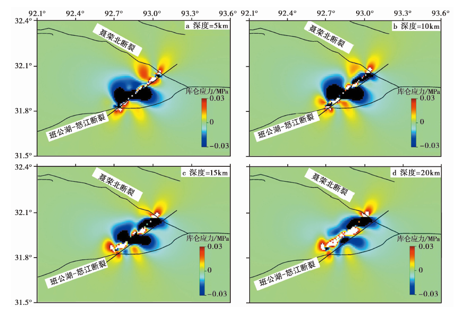
Fig. 7 Coulomb stress changes at different depths(The receiving fault is Bangong Lake-Nujiang Fault).
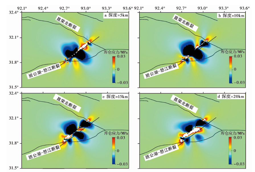
Fig. 8 Coulomb stress changes at different depths(The receiving fault is Nierongbei Fault).
| [1] |
邓起东, 程绍平, 马冀, 等. 2014. 青藏高原地震活动特征及当前地震活动形势[J]. 地球物理学报, 57(7): 2025-2042.
|
|
|
|
| [2] |
冯万鹏, 许力生, 许忠淮, 等. 2009. 利用InSAR资料反演2008年西藏改则 MW6.4 和 MW5.9 地震的断层参数[J]. 地球物理学报, 52(4): 983-993.
|
|
|
|
| [3] |
李才, 翟刚毅, 王立全, 等. 2009. 认识青藏高原的重要窗口: 羌塘地区近年来研究进展评述(代序)[J]. 地质通报, 28(9): 1169-1177.
|
|
|
|
| [4] |
李承涛, 李琦, 谭凯, 等. 2021. 2020年西藏尼玛 MW6.3 地震InSAR同震形变特征与破裂滑动分布[J]. 地球物理学报, 64(7): 2297-2310.
|
|
|
|
| [5] |
李建华. 1998. 利用卫星图像研究西藏羌塘及邻区的断裂活动性[J]. 地震地质, 20(3): 201-207.
|
|
|
|
| [6] |
单新建, 马瑾, 王长林, 等. 2002. 利用星载D-InSAR技术获取的地表形变场提取玛尼地震震源断层参数[J]. 中国科学(D辑), 32(10): 837-844.
|
|
|
|
| [7] |
王晓航. 2019. 2016年呼图壁地震的InSAR观测与发震构造分析[D]. 武汉: 武汉大学:25-30.
|
|
|
|
| [8] |
张国宏. 2011. 断层滑动分布与震源破裂过程联合反演研究[D]. 北京: 中国地震局地质研究所:44-49.
|
|
|
|
| [9] |
张培震, 王琪, 马宗晋. 2002. 青藏高原现今构造变形特征与GPS速度场[J]. 地学前缘, 9(2): 442-450.
|
|
|
|
| [10] |
|
| [11] |
|
| [12] |
DOI URL |
| [13] |
DOI URL |
| [14] |
DOI URL |
| [15] |
|
| [16] |
|
| [17] |
DOI URL |
| [18] |
|
| [1] | JIANG Feng-yun, JI Ling-yun, ZHU Liang-yu, LIU Chuan-jin. THE PRESENT CRUSTAL DEFORMATION CHARACTERISTICS OF THE HAIYUAN-LIUPANSHAN FAULT ZONE FROM INSAR AND GPS OBSERVATIONS [J]. SEISMOLOGY AND GEOLOGY, 2023, 45(2): 377-400. |
| [2] | ZHAO De-zheng, QU Chun-yan, ZHANG Gui-fang, GONG Wen-yu, SHAN Xin-jian, ZHU Chuan-hua, ZHANG Guo-hong, SONG Xiao-gang. APPLICATIONS AND ADVANCES FOR THE COSEISMIC DEFORMA-TION OBSERVATIONS, EARTHQUAKE EMERGENCY RESPONSE AND SEISMOGENIC STRUCTURE INVESTIGATION USING INSAR [J]. SEISMOLOGY AND GEOLOGY, 2023, 45(2): 570-592. |
| [3] | JIN Li-zhou, WANG Ying, CHANG Wen-bin, TIAN Ying-ying, YUAN Ren-mao. STABILITY ANALYSIS OF THE BAIGE LANDSLIDE USING D-INSAR AND PFC2D MODELING [J]. SEISMOLOGY AND GEOLOGY, 2023, 45(1): 153-171. |
| [4] | YU Shu-yuan, HUANG Xian-liang, ZHENG Hai-gang, LI Ling-li, LUO Jia-ji, DING Juan, FAN Xiao-ran. THE COSEISMIC RUPTURE MODEL AND STRESS CHANGE OF THE 2022 MENYUAN MW6.7 EARTHQUAKE [J]. SEISMOLOGY AND GEOLOGY, 2023, 45(1): 286-303. |
| [5] | HUA Jun, GONG Wen-yu, SHAN Xin-jian, WANG Zhen-jie, JI Ling-yun, LIU Chuan-jin, LI Yong-sheng. RESEARCH ON INTEGRATING INTERSEISMIC DEFORMATION RATE FIELDS OF MULTI-TRACK INSAR [J]. SEISMOLOGY AND GEOLOGY, 2022, 44(5): 1172-1189. |
| [6] | WANG Yu-qing, FENG Wan-peng, ZHANG Pei-zhen. PRESENT DEFORMATION OF~90° INTERSECTING CONJUGATE FAULTS AND MECHANICAL IMPLICATION TO REGIONAL TECTONICS: A CASE STUDY OF 2019 MW≥6.4 PHILIPPINES EARTHQUAKE SEQUENCE [J]. SEISMOLOGY AND GEOLOGY, 2022, 44(2): 313-332. |
| [7] | XU Fang, LU Ren-qi, WANG Shuai, JIANG Guo-yan, LONG Feng, WANG Xiao-shan, SU Peng, LIU Guan-shen. STUDY ON THE SEISMOTECTONICS OF THE QINGBAIJIANG MS5.1 EARTHQUAKE IN SICHUAN PROVINCE IN 2020 BY MULTIPLE CONSTRAINT METHOD [J]. SEISMOLOGY AND EGOLOGY, 2022, 44(1): 220-237. |
| [8] | QIU Jiang-tao, JI Ling-yun, LIU lei, LIU Chuan-jin. INSAR COSEISMIC DEFORMATION AND TECTONIC IMPLICATIONS FOR THE 2020 MW6.3 NIMA EARTHQUAKE IN XIZANG [J]. SEISMOLOGY AND EGOLOGY, 2021, 43(6): 1586-1599. |
| [9] | XU Xiao-xue, JI Ling-yun, ZHU Liang-yu, WANG Guang-ming, ZHANG Wen-ting, LI Ning. THE CO-SEISMIC DEFORMATION CHARACTERISTICS AND SEISMOGENIC STRUCTURE OF THE YANGBI MS6.4 EARTHQUAKE [J]. SEISMOLOGY AND EGOLOGY, 2021, 43(4): 771-789. |
| [10] | LIU Rui-chun, ZHANG Jin, GUO Wen-feng, CHEN Hui, ZHENG Ya-di, CHENG Cheng. STUDY ON THE RECENT DEFORMATION CHARACTERISTIC AND STRUCTURAL DEFORMATION MODEL OF THE SOUTH-EASTERN MARGIN OF ORDOS BLOCK [J]. SEISMOLOGY AND GEOLOGY, 2021, 43(3): 540-558. |
| [11] | JIA Rui, ZHANG Guo-hong, XIE Chao-di, SHAN Xin-jian, ZHANG Ying-feng, LI Cheng-long, HUANG Zi-cheng. COSEISMIC DEFORMATION FIELD AND FAULT SLIP MODEL OF THE MW6.0 PAKISTAN EARTHQUAKE CONSTRAINED BY SENTINEL-1A SAR DATA [J]. SEISMOLOGY AND GEOLOGY, 2021, 43(3): 600-613. |
| [12] | WANG Shao-jun, LIU Yun-hua, SHAN Xin-jian, QU Chun-yan, ZHANG Guo-hong, XIE Zhao-di, ZHAO De-zheng, FAN Xiao-ran, HUA Jun, LIANG Shi-ming, ZHANG Ke-liang, DAI Cheng-long. COSEISMIC SURFACE DEFORMATION AND SLIP MODELS OF THE 2021 MS6.4 YANGBI(YUNNAN, CHINA)EARTHQUAKE [J]. SEISMOLOGY AND GEOLOGY, 2021, 43(3): 692-705. |
| [13] | HUA Jun, ZHAO De-zheng, SHAN Xin-jian, QU Chun-yan, ZHANG Ying-feng, GONG Wen-yu, WANG Zhen-jie, LI Cheng-long, LI Yan-chuan, ZHAO Lei, CHEN Han, FAN Xiao-ran, WANG Shao-jun. COSEISMIC DEFORMATION FIELD, SLIP DISTRIBUTION AND COULOMB STRESS DISTURBANCE OF THE 2021 MW7.3 MADUO EARTHQUAKE USING SENTINEL-1 INSAR OBSERVATIONS [J]. SEISMOLOGY AND GEOLOGY, 2021, 43(3): 677-691. |
| [14] | ZHANG Ying-feng, SHAN Xin-jian, ZHANG Guo-hong, LI Cheng-long, WEN Shao-yan, XIE Quan-cai. THE DEFORMATION OF 2020 MW6.0 KALPINTAGE EARTHQUAKE AND ITS IMPLICATION FOR THE REGIONAL RISK ESTIMATES [J]. SEISMOLOGY AND GEOLOGY, 2021, 43(2): 377-393. |
| [15] | ZHANG Wen-ting, JI Ling-yun, ZHU Liang-yu, JIANG Feng-yun, XU Xiao-xue. A TYPICAL THRUST RUPTURE EVENT OCCURRING IN THE FORELAND BASIN OF THE SOUTHERN TIANSHAN: THE 2020 XINJIANG JIASHI MS6.4 EARTHQUAKE [J]. SEISMOLOGY AND GEOLOGY, 2021, 43(2): 394-409. |
| Viewed | ||||||
|
Full text |
|
|||||
|
Abstract |
|
|||||
