
SEISMOLOGY AND GEOLOGY ›› 2023, Vol. 45 ›› Issue (2): 338-354.DOI: 10.3969/j.issn.0253-4967.2023.02.003
Previous Articles Next Articles
NEW ACTIVITY PHENOMENA REVEALED BY TRENCH ON THE NORTH SIDE OF NÜSHAN LAKE IN THE TANLU FAULT ZONE AND DISCUSSION
ZHAO Peng1,2)( ), LI Jun-hui1), TAO Yue-chao1), SHU Peng1),*(), FANG Zhen1,3)
- 1)Anhui Earthquake Agency, Hefei 230031, China
2)Key Laboratory of Research on the Middle and Southern Segment of the Tanlu Fault Zone, Hefei 230031, China
3)Anhui Mengcheng National Geophysical Field Scientific Observation and Research Station, Hefei 230031, China
-
Revised:2022-07-15Online:2023-04-20Published:2023-05-18
郯庐断裂带女山湖北侧探槽的新活动现象及讨论
赵朋1,2)(), 李军辉1), 陶月潮1), 疏鹏1),*(), 方震1,3)
- 1)安徽省地震局, 合肥 230031
2)郯庐断裂带中南段重点研究室, 合肥 230031
3)安徽蒙城地球物理国家野外科学观测研究站, 合肥 230031
-
通讯作者:*疏鹏, 男, 1989年生, 工程师, 主要研究方向为活动构造, E-mail:shupeng0607@163.com 。 -
作者简介:赵朋, 男, 1982年生, 2009年于中国地震局地质研究所获构造地质学专业硕士学位, 高级工程师, 研究方向为地震地质、地震预测, E-mail: zp20131688@163.com。 -
基金资助:安徽省地震科研基金青年项目(20220203);大别山监测预报实验场及郯庐断裂带探测项目(2018-340000-74-01-009017);中国地震局地震科技星火计划项目(XH19017Y);蒙城地球物理国家野外科学观测研究站基金(MEMGO-202215)
CLC Number:
Cite this article
ZHAO Peng, LI Jun-hui, TAO Yue-chao, SHU Peng, FANG Zhen. NEW ACTIVITY PHENOMENA REVEALED BY TRENCH ON THE NORTH SIDE OF NÜSHAN LAKE IN THE TANLU FAULT ZONE AND DISCUSSION[J]. SEISMOLOGY AND GEOLOGY, 2023, 45(2): 338-354.
赵朋, 李军辉, 陶月潮, 疏鹏, 方震. 郯庐断裂带女山湖北侧探槽的新活动现象及讨论[J]. 地震地质, 2023, 45(2): 338-354.
share this article
Add to citation manager EndNote|Ris|BibTeX
URL: https://www.dzdz.ac.cn/EN/10.3969/j.issn.0253-4967.2023.02.003

Fig. 1 Location of the study area.
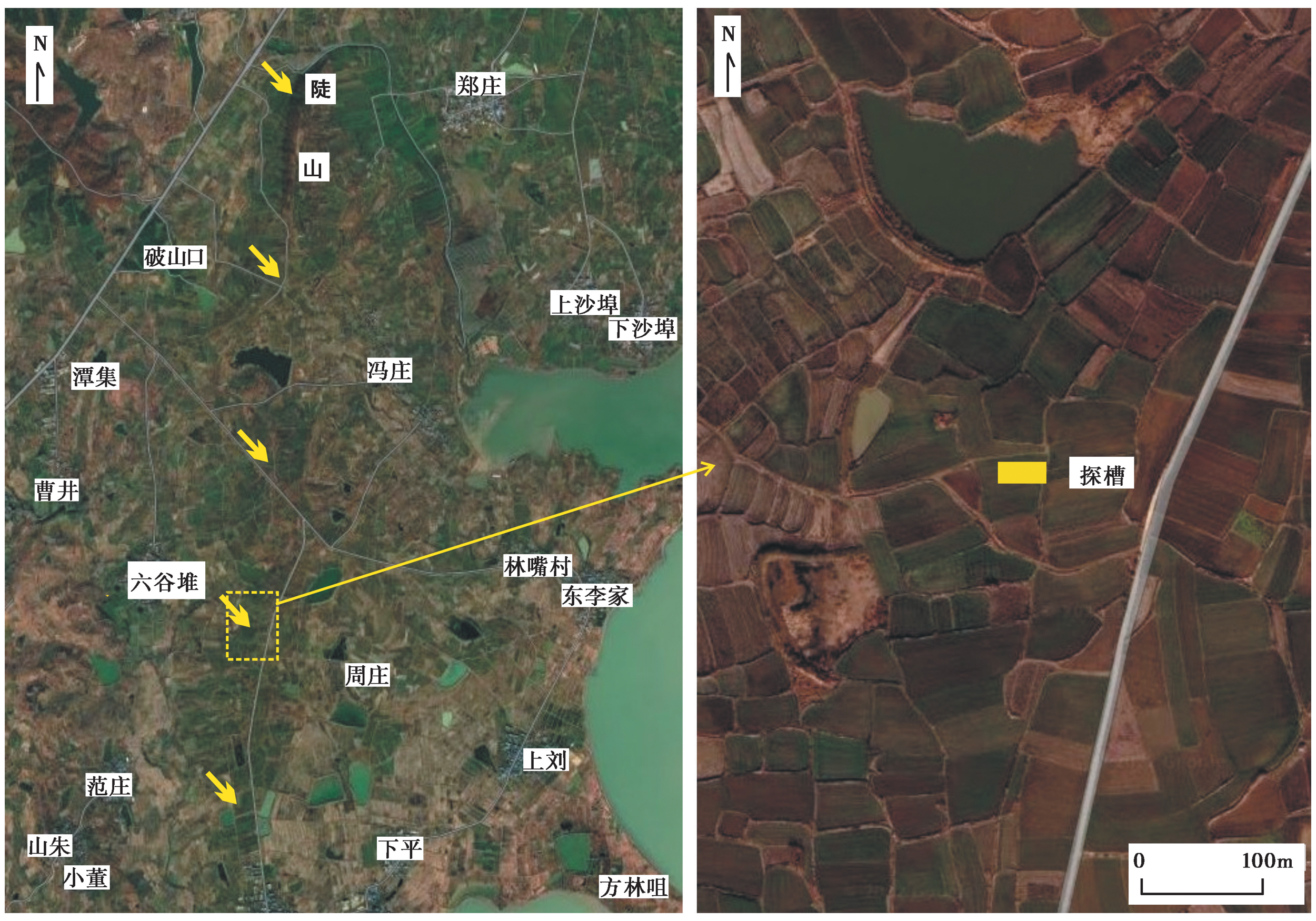
Fig. 2 Satellite image of Doushan-Liugudui section(Google Earth).
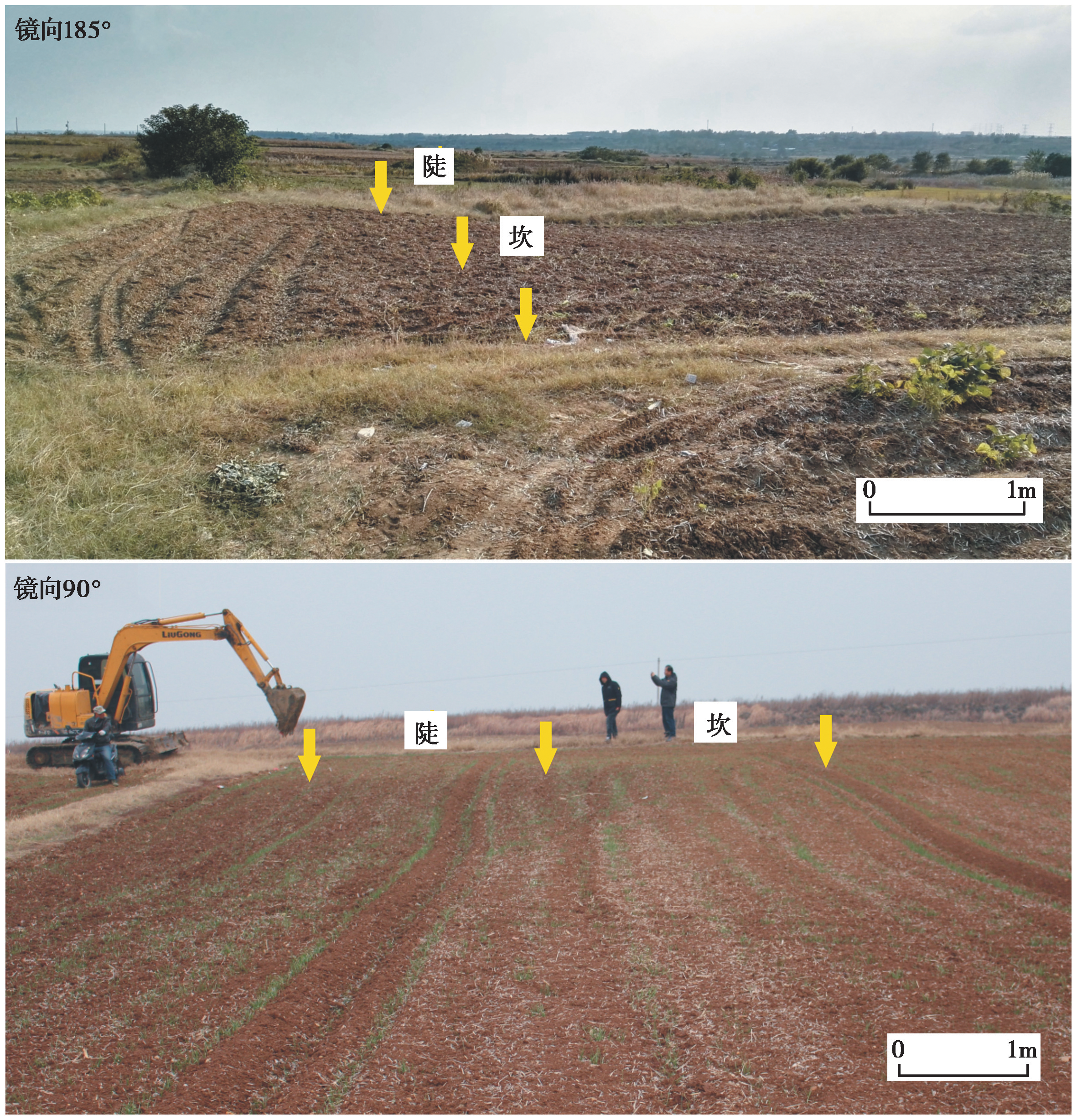
Fig. 3 Slope scarp at the Liugudui trench site.
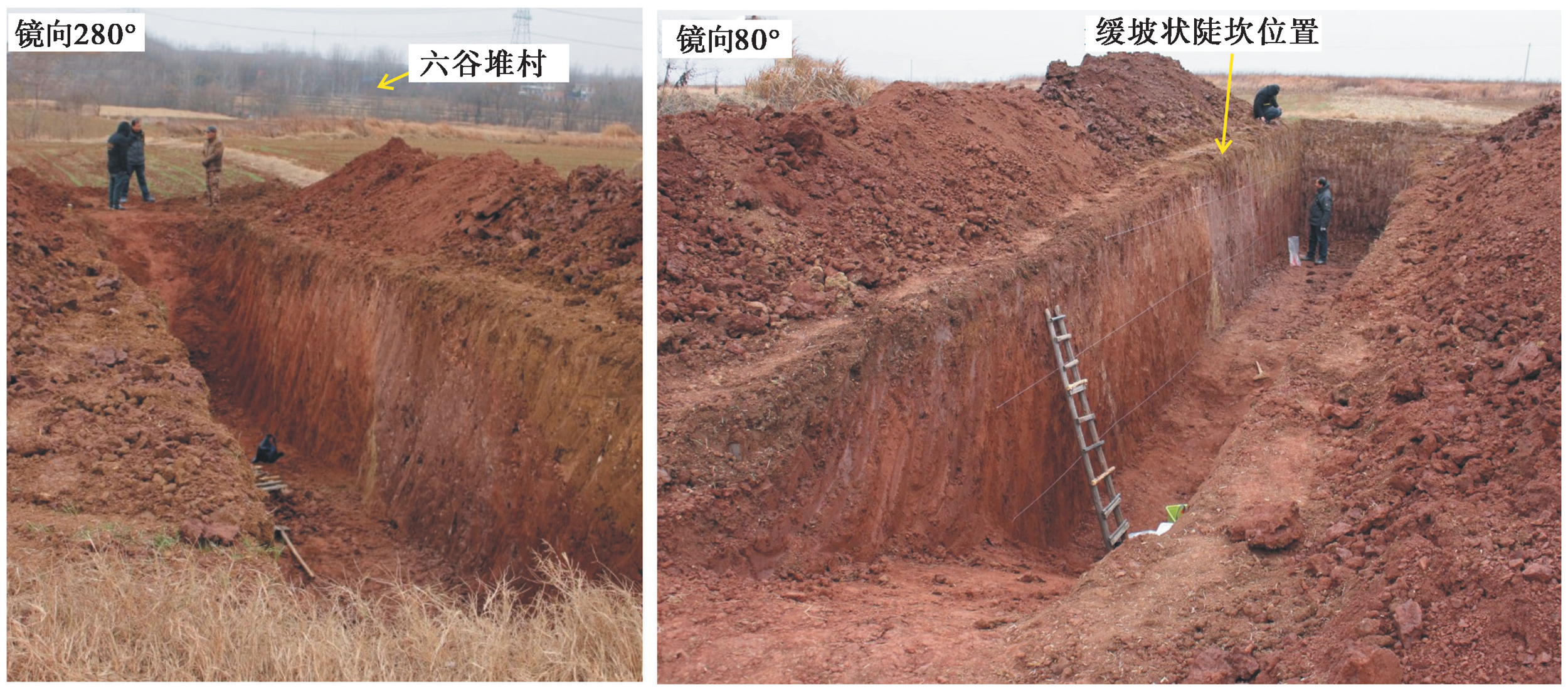
Fig. 4 Photos of Liugudui trench.

Fig. 5 Photos and profile of the south wall of Liugudui trench.

Fig. 6 Photos and profile of the north wall of Liugudui trench.
| 编号 | 采样位置 | 测量方法 | 环境剂量率/Gy·ka-1 | 年龄/ka |
|---|---|---|---|---|
| LGD1-1 | 南壁f2黏土团 | SMAR | 3.74±0.24 | 52.97±8.75 |
| LGD1-3 | 南壁U3层下部 | SMAR | 3.51±0.22 | 22.19±2.4 |
| LGD1-6 | 南壁U2层上部 | SMAR | 3.63±0.24 | 50.92±4.65 |
| LGD1-2-3 | 南壁U2层上部 | SMAR | 3.52±0.23 | 51.87±5.3 |
| LGD1-8 | 北壁U2层上部 | SMAR | 3.56±0.24 | 53.3±6.41 |
| LGD1-9 | 北壁f1黏土团 | SMAR | 4.25±0.28 | 52.09±6.98 |
| LGD1-10 | 北壁U3层下部 | SMAR | 4.08±0.27 | 27.12±2.26 |
Table1 OSL sample dating results of Liugudui trench
| 编号 | 采样位置 | 测量方法 | 环境剂量率/Gy·ka-1 | 年龄/ka |
|---|---|---|---|---|
| LGD1-1 | 南壁f2黏土团 | SMAR | 3.74±0.24 | 52.97±8.75 |
| LGD1-3 | 南壁U3层下部 | SMAR | 3.51±0.22 | 22.19±2.4 |
| LGD1-6 | 南壁U2层上部 | SMAR | 3.63±0.24 | 50.92±4.65 |
| LGD1-2-3 | 南壁U2层上部 | SMAR | 3.52±0.23 | 51.87±5.3 |
| LGD1-8 | 北壁U2层上部 | SMAR | 3.56±0.24 | 53.3±6.41 |
| LGD1-9 | 北壁f1黏土团 | SMAR | 4.25±0.28 | 52.09±6.98 |
| LGD1-10 | 北壁U3层下部 | SMAR | 4.08±0.27 | 27.12±2.26 |
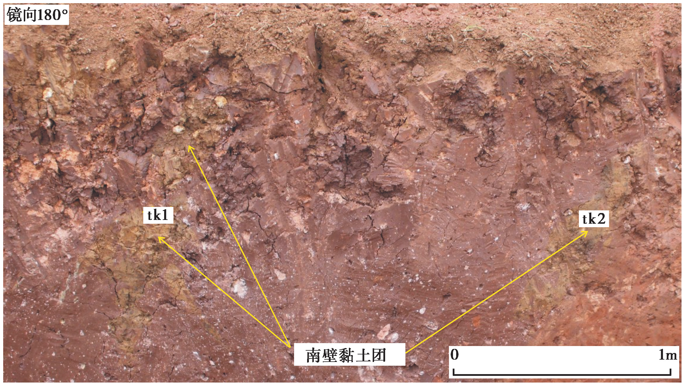
Fig. 7 Clay mass in fault deformation zone of the southern wall.

Fig. 8 Fault F3 on the north and south walls of the trench(local exhumation in fault).

Fig. 9 Photos of f3 fault staggered to the surface.
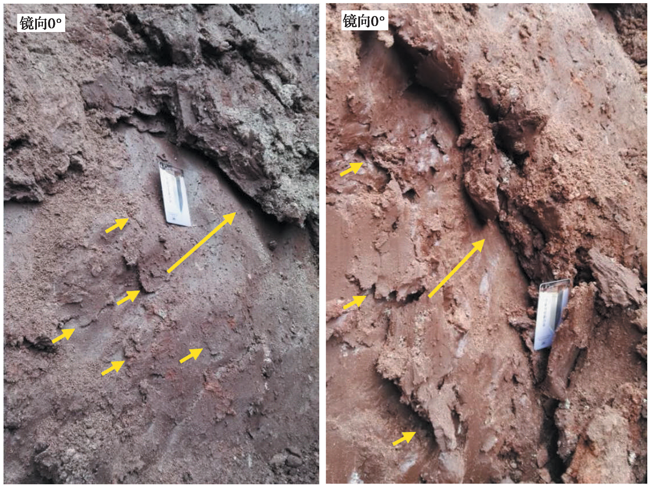
Fig. 10 Photos of fault slickensides.
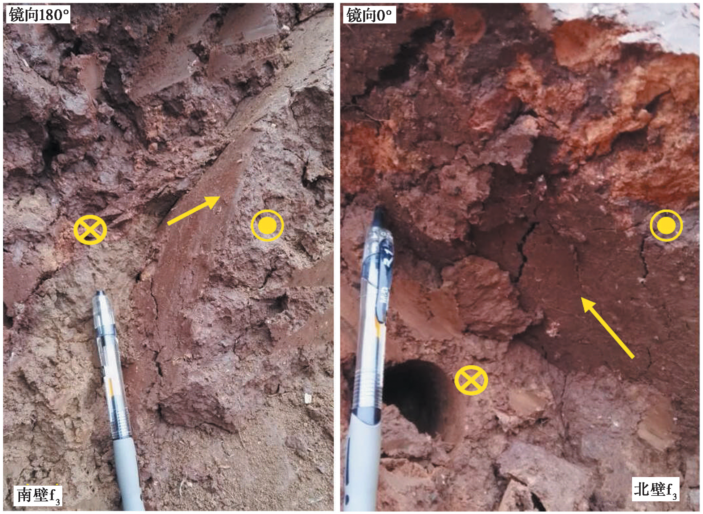
Fig. 11 Partial view of f3 fault plane profile.
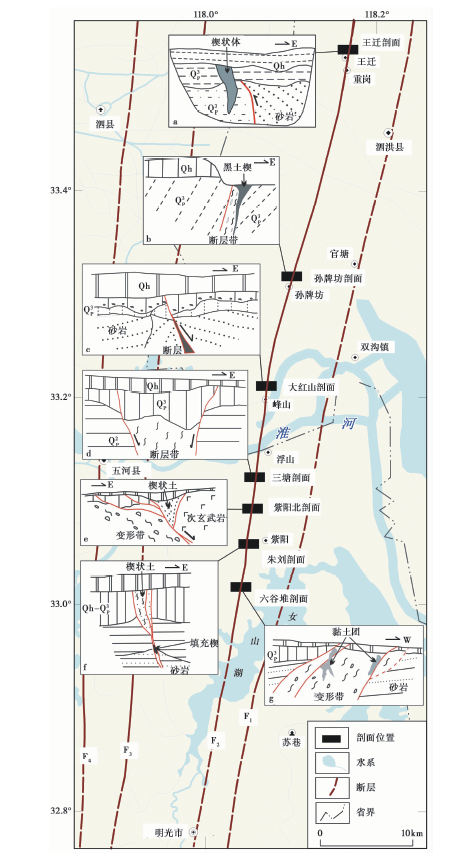
Fig. 12 Profiles of fault activity phenomena in Sihong-Mingguang section of Tanlu fault zone.
| [1] |
曹筠, 冉勇康, 许汉刚, 等. 2015. 宿迁城市活动断层探测多方法技术运用的典型案例[J]. 地震地质, 37(2): 430-439. doi: 10.3969/j.issn.0253-4967.2015.02.007.
DOI |
| CAO Jun, RAN Yong-kang, XU Han-gang, et al. 2015. Typical case analysis on application of multi-method detection technique to active fault exploration in Suqian City[J]. Seismology and Geology, 37(2): 430-439. (in Chinese) | |
| [2] | 晁洪太, 李家灵, 崔昭文, 等. 1994. 郯庐断裂带中段全新世活断层的几何结构与分段 G∥国家地震局地质研究所编. 活动断裂研究(3). 北京: 地震出版社. |
| CHAO Hong-tai, LI Jia-ling, CUI Zhao-wen, et al. 1994. Geometry and segmentation of the Quaternary fault in the middle segment of the Tanlu fault zone [G]∥Institute of Geology, SSB(ed).Research of Active Fault (3). Seismological Press, Beijing. (in Chinese) | |
| [3] | 晁洪太, 李家灵, 崔昭文, 等. 1997. 郯庐断裂带潍坊-嘉山段全新世活断层的活动方式与发震模式[J]. 地震研究, 20(2): 218-226. |
| CHAO Hang-tai, LI Jia-ling, CUI Zhao-wen, et al. 1997. Mode of motion of the Holocene fault in Weifang-Jiashan segment of the Tanlu fault zone and earthquake-generating model[J]. Journal of Seismological Research, 20(2): 218-226. (in Chinese) | |
| [4] | 方仲景, 丁梦林, 计凤桔, 等. 1980. 郯城-庐江断裂带地质活动的地质分析[J]. 地震地质, 2(4): 39-46. |
| FANG Zhong-jing, DING Meng-lin, JI Feng-ju, et al. 1980. Geological analysis of the seismicity in the Tancheng-Lujiang fault zone, East China[J]. Seismology and Geology, 2(4): 39-46. (in Chinese) | |
| [5] | 方仲景, 计凤桔, 向宏发, 等. 1976. 郯庐带中段第四纪断裂活动特征与地震地质条件述评[J]. 地质科学, 4: 354-366. |
| FANG Zhong-jing, JI Feng-ju, XIANG Hong-fa, et al. 1976. The characteristics of Quaternary movements along the middle segment of the old Tancheng-Lujiang fracture-zone and their seismogeologic conditions[J]. Chinese Journal of Geology, 4:354-366. (in Chinese) | |
| [6] | 高维明, 郑朗荪. 1991. 郯庐断裂带的活断层分段与潜在震源区的划分[J]. 中国地震, 7(1): 87-91. |
| GAO Wei-ming, ZHENG Lang-sun. 1991. Active fault segmentation and the identification of potential seismic zones along the Taulu Fault[J]. Earthquake Research in China, 7(1): 87-91. (in Chinese) | |
| [7] | 国家地震局地质研究所. 1987. 郯庐断裂[M]. 北京: 地震出版社. |
| Institute of Geology, China Earthquake Administration. 1987. The Tanlu Fault Zone[M]. Seismological Press, Beijing. (in Chinese) | |
| [8] | 何宏林, 宋方敏, 李传友, 等. 2004. 郯庐断裂带莒县胡家孟晏地震破裂带的发现[J]. 地震地质, 26(4): 630-637. |
| HE Hong-lin, SONG Fang-min, LI Chuan-you, et al. 2004. Hujiamengyan surface rupture in Juxian County, Shandong Province: A new discovery on the Tanlu fault zone[J]. Seismology and Geology, 26(4): 630-637. (in Chinese) | |
| [9] | 侯明金, 朱光, Jacques M, 等. 2007. 郯庐断裂带(安徽段)及邻区的动力学分析与区域构造演化[J]. 地质科学, 42(4): 362-381. |
| HOU Ming-jin, ZHU Guang, Jacques M, et al. 2007. Analyzing on geodynamics and regional tectonic evolution of the Tan-Lu fault zone(Anhui segment)and its environs[J]. Chinese Journal of Geology, 42(4): 362-381. (in Chinese) | |
| [10] |
计昊旻, 李安, 张世民. 2021. 基于冲沟右旋水平位错的安丘-莒县断裂地震特征位移分析[J]. 地震地质, 43(3): 471-487. doi: 10.3969/j.issn.0253-4967.2021.03.001.
DOI |
| JI Hao-min, LI An, ZHANG Shi-min. 2021. Analysis on the seismic characteristic displacement of Anqiu-Juxian Fault based on dextral horizontal dislocation of gully[J]. Seismology and Geology, 43(3): 471-487. (in Chinese) | |
| [11] | 李家灵, 晁洪太, 崔昭文, 等. 1991. 郯庐断裂带郯城-新沂段活断层研究 G∥国家地震局地质研究所编. 活动断裂研究(1). 北京: 地震出版社: 164-173. |
| LI Jia-ling, CHAO Hong-tai, CUI Zhao-wen, et al. 1991. Researches on the active fault of the Tancheng-Xinyi segment of the Tanlu Fault [G]∥Institute of Geology, SSB(ed). Research of Active Fault (1).Seismological Press, Beijing: 164-173. (in Chinese) | |
| [12] | 李家灵, 晁洪太, 崔昭文, 等. 1994. 1668年郯城8.5级地震断层及其破裂机制[J]. 地震地质, 16(3): 229-237. |
| LI Jia-ling, CHAO Hong-tai, CUI Zhao-wen, et al. 1994. Seismic fault of the 1668 Tancheng earthquake(M=8.5) and its fracture mechanism[J]. Seismology and Geology, 16(3): 229-237. (in Chinese) | |
| [13] | 李腊月, 李玉江, 张风霜, 等. 2020. 郯庐断裂带中南段闭锁特征与地震危险性分析[J]. 地质学报, 94(2): 467-479. |
|
LI La-yue, LI Yu-jiang, ZHANG Feng-shuang, et al. 2020. Fault blocking characteristics and seismic hazard analysis in the middle and southern segments of the Tanlu fault zone[J]. Acta Geologica Sinica, 94(2): 467-479. (in Chinese)
DOI URL |
|
| [14] | 李起彤. 1994. 郯庐断裂带江苏段全新世活动新证据 [G]∥中国地震学会地震地质专业委员会编. 中国活动断层研究. 北京: 地震出版社: 140-145. |
| LI Qi-tong. 1994. New evidence for the Holocene movement along the Jiangsu segment of the Tancheng-Lujiang Fault zone [G]∥Committee on Seismogeology, Seismological Society of China(ed). Research of Active Faults in China. Seismological Press, Beijing: 140-145. (in Chinese) | |
| [15] |
闵伟, 焦德成, 周本刚, 等. 2011. 依兰-伊通断裂全新世活动的新发现及其意义[J]. 地震地质, 33(1): 141-150. doi: 10.3969/j.issn.0253-4967.2011.01.014.
DOI |
| MIN Wei, JIAO De-cheng, ZHOU Ben-gang, et al. 2011. The significance of discovery on Holocene activity on the Yilan-Yitong Fault in Northeast China[J]. Seismology and Geology, 33(1): 141-150. (in Chinese) | |
| [16] |
秦晶晶, 刘保金, 王志才, 等. 2022. 利用地震反射剖面探测研究安丘-莒县断裂板泉段的浅部构造特征[J]. 地震地质, 44(2): 349-362. doi: 10.3969/j.issn.0253-4967.2022.02.005.
DOI |
| QIN Jing-jing, LIU Bao-jin, WANG Zhi-cai, et al. 2022. Research on shallow structural characteristics in the Banquan segment of Anqiu-Juxian fault zone based on shallow seismic reflection profiling[J]. Seismology and Geology, 44(2): 349-362. (in Chinese) | |
| [17] |
沈小七, 姚大全, 郑海刚, 等. 2015. 郯庐断裂带重岗山-王迁段晚更新世以来的活动习性[J]. 地震地质, 37(1): 139-148. doi: 10.3969/j.issn.0253-4967.2015.01.011.
DOI |
| SHEN Xiao-qi, YAO Da-quan, ZHENG Hai-gang, et al. 2015. The research on activity behavior of Chonggangshan-Wangqian segment of Tan-Lu fault zone since late Pleistocene[J]. Seismology and Geology, 37(1): 139-148. (in Chinese) | |
| [18] | 宋方敏, 杨晓平, 何宏林, 等. 2005. 山东安丘-莒县断裂小店子-茅埠段新活动及其定量研究[J]. 地震地质, 27(2): 200-211. |
| SONG Fang-min, YANG Xiao-ping, HE Hong-lin, et al. 2005. Quantitative analysis of recent activity of the Xiaodianzi-Maobu segment of the Anqiu-Juxian Fault, Shandong Province[J]. Seismology and Geology, 27(2): 200-211. (in Chinese) | |
| [19] |
孙业君, 黄耘, 刘泽民, 等. 2021. 郯庐断裂带苏鲁皖段及邻区构造应力场特征及其动力学意义[J]. 地震地质, 43(5): 1188-1207. doi: 10.3969/j.issn.0253-4967.2021.05.010.
DOI |
| SUN Ye-jun, HUANG Yun, LIU Ze-min, et al. 2021. Characteristics of tectonic stress field and dynamic significance in the Shandong-Jiangsu-Anhui segment of Tancheng-Lujiang fault zone and its adjacent areas[J]. Seismology and Geology, 43(5): 1188-1207. (in Chinese) | |
| [20] | 汤有标, 姚大全. 1990. 郯庐断裂带赤山段晚更新世以来的活动性[J]. 中国地震, 6(2): 63-69. |
| TANG You-biao, YAO Da-quan. 1990. Activity since late Pleistocene on Chishan segment of the Tancheng-Lujiang fault zone[J]. Earthquake Research in China, 6(2): 63-69. (in Chinese) | |
| [21] | 王志才, 贾荣光, 孙昭民, 等. 2005. 沂沭断裂带安丘-莒县断裂安丘-朱里段几何结构与活动特征[J]. 地震地质, 27(2): 212-220. |
| WANG Zhi-cai, JIA Rong-guang, SUN Zhao-min, et al. 2005. Geometry and activity of the Anqiu-Zhuli segment of the Anqiu-Juxian Fault in the Yishu fault zone[J]. Seismology and Geology, 27(2): 212-220. (in Chinese) | |
| [22] |
杨源源, 赵朋, 郑海刚, 等. 2017. 郯庐断裂带安徽紫阳山段发现全新世活动证据[J]. 地震地质, 39(4): 644-655. doi: 10.3969/j.issn.0253-4967.2017.04.002.
DOI |
| YANG Yuan-yuan, ZHAO Peng, ZHENG Hai-gang, et al. 2017. Evidence of Holocene activity discovered in Anhui Ziyangshan segment of Tanlu fault zone[J]. Seismology and Geology, 39(4): 644-655. (in Chinese) | |
| [23] |
余中元, 张培震, 闵伟, 等. 2016. 依兰-伊通断裂带尚志段晚全新世以来的强震复发间隔: 来自古地震与历史文献的约束[J]. 地震地质, 38(4): 844-861. doi: 10.3969/j.issn.0253-4967.2016.04.004.
DOI |
| YU Zhong-yuan, ZHANG Pei-zhen, MIN Wei, et al. 2016. Late Holocene average recurrence interval of great earthquakes of Shangzhi part of the Yilan-Yitong fault zone, NE China: Constraints from paleo-earthquakes and historical written records[J]. Seismology and Geology, 38(4): 844-861. (in Chinese) | |
| [24] | 翟炳松, 侍继成, 杨一冲. 1992. 郯庐断裂带泗洪段全新世活动性初步研究[J]. 地震, (5): 61-64. |
| ZHAI Bing-song, SHI Ji-cheng, YANG Yi-chong. 1992. Preliminary research on recent activity along Sihong segment of Tan-Lu fault zone[J]. Earthquake, (5): 61-64. (in Chinese) | |
| [25] |
张鹏, 李丽梅, 冉勇康, 等. 2015. 郯庐断裂带安丘-莒县断裂江苏段晚第四纪活动特征研究[J]. 地震地质, 37(4): 1162-1176. doi: 10.3969/j.issn.0253-4967.2015.04.018.
DOI |
| ZHANG Peng, LI Li-mei, RAN Yong-kang, et al. 2015. Research on characteristics of late Quaternary activity of the Jiangsu segment of Anqiu-Juxian Fault in the TanLu fault zone[J]. Seismology and Geology, 37(4): 1162-1176. (in Chinese) | |
| [26] |
张鹏, 张媛媛, 李丽梅, 等. 2019. 郯庐断裂带安丘-莒县断裂江苏段全新世活动的新证据[J]. 地震地质, 41(3): 576-586. doi: 10.3969/j.issn.0253-4967.2019.03.003.
DOI |
| ZHANG Peng, ZHANG Yuan-yuan, LI Li-mei, et al. 2019. New evidences of Holocene activity in the Jiangsu segment of Anqiu-Juxian Fault of the Tanlu fault zone[J]. Seismology and Geology, 41(3): 576-586. (in Chinese) | |
| [27] |
赵朋, 姚大全, 杨源源, 等. 2017. 郯庐断裂带安徽浮山段晚第四纪以来活动新发现[J]. 地震地质, 39(5): 889-903. doi: 10.3969/j.issn.0253-4967.2017.05.002.
DOI |
| ZHAO Peng, YAO Da-quan, YANG Yuan-yuan, et al. 2017. A new discovery of activity of Fushan section of the Tan-Lu fault zone in the late Quaternary[J]. Seismology and Geology, 39(5): 889-903. (in Chinese) | |
| [28] |
赵朋, 姚大全, 郑海刚, 等. 2018. 郯庐断裂带安徽明光段紫阳山探槽及其意义[J]. 中国地震, 34(4): 642-651. doi: 10.3969/j.issn.0253-4967.2017.03.008.
DOI |
| ZHAO Peng, YAO Da-quan, ZHENG Hai-gang, et al. 2018. The Ziyang Hill trenches in the Anhui Mingguang section of the Tan-Lu fault zone and their significance[J]. Earthquake Research in China, 34(4): 642-651. (in Chinese) | |
| [29] |
朱艾斓, 徐锡伟, 王鹏, 等. 2018. 以精定位背景地震活动与震源机制解研究郯庐断裂带中南段现今活动习性[J]. 地学前缘, 25(1): 218-226.
DOI |
| ZHU Ai-lan, XU Xi-wei, WANG Peng, et al. 2018. The present activity of the central and southern segments of the Tancheng-Lujiang fault zone evidenced from relocated microseismicity and focal mechanisms[J]. Earth Science Frontiers, 25(1): 218-226. (in Chinese) | |
| [30] | Min W, Liu Y G, Jiao D C, et al. 2013. Evidence for Holocene activity of the Yilan-Yitong Fault, northeastern section of the Tan-Lu fault zone in Northeast China[J]. Journal of Asian Earth Sciences, 67-68: 207-216. |
| [31] |
Wang Z C, Deng Q D, Du X S, et al. 2006. Active fault survey on the Tanlu fault zone in Laizhou Bay[J]. Acta Seismologica Sinica, 19(5): 530-541.
DOI URL |
| [1] | LI Xi-bing, TAO Xiao-san, GU Qin-ping, PENG Xiao-bo, WANG Yu, ZHU Feng. P-WAVE VELOCITY STRUCTURE OF THE CRUST AND UPPER-MOST MANTLE IN THE CENTRAL AND SOUTHERN SEGMENT OF TANLU FAULT ZONE AND ITS TECTONIC IMPLICATION [J]. SEISMOLOGY AND GEOLOGY, 2026, 48(2): 423-441. |
| [2] | LUO Jia-xin, LI Bin, LI Zi-hong, FAN Kun. CHARACTERISTICS OF VERTICAL SLIP RATE EVOLUTION ALONG THE JIAOCHENG FAULT ZONE, SHANXI, SINCE LATE PLEISTOCENE [J]. SEISMOLOGY AND GEOLOGY, 2026, 48(1): 43-63. |
| [3] | YANG Yuan-yuan, LI Peng-fei, LU Shuo, SHU Peng, PAN Hao-bo, FANG Liang-hao, ZHENG Hai-gang, ZHAO Peng, ZHENG Ying-ping, YAO Da-quan. PALEOEARTHQUAKES AND VERTICAL SLIP RATES ON THE HUAI RIVER-NÜSHAN LAKE SEGMENT OF FAULT F5 IN THE MIDDLE SECTION OF THE TANLU FAULT ZONE [J]. SEISMOLOGY AND GEOLOGY, 2022, 44(6): 1365-1383. |
| [4] | QIN Jing-jing, LIU Bao-jin, WANG Zhi-cai, FENG Shao-ying, DENG Xiao-juan, HUA Xin-sheng, LI Qian. RESEARCH ON SHALLOW STRUCTURAL CHARACTERISTICS IN THE BANQUAN SEGMENT OF ANQIU-JUXIAN FAULT ZONE BASED ON SHALLOW SEISMIC REFLECTION PROFILING [J]. SEISMOLOGY AND GEOLOGY, 2022, 44(2): 349-362. |
| [5] | LI Zheng-fang, ZHOU Ben-gang, XIAO Hai-bo. EVALUATION OF RYUKYU-MANILA TRENCH TECTONIC BACKGROUND AND SEISMOGENIC ABILITY [J]. SEISMOLOGY AND EGOLOGY, 2021, 43(6): 1381-1397. |
| [6] | CHANG Zu-feng, CHANG Hao, LI Jian-lin, MAO Ze-bin, ZANG Yang. HOLOCENE ACTIVITY AND PALEOEARTHQUAKES OF THE WEIXI-QIAOHOU FAULT [J]. SEISMOLOGY AND EGOLOGY, 2021, 43(4): 881-898. |
| [7] | WEI Yong, XU Qiang, DONG Xiu-jun, GUO Peng, LI Song-lin, LI Hua-jin. PRACTICAL APPLICATION OF CLOSE-RANGE PHOTOGRAM-METRY TO EXTRACTING GEOLOGICAL INFORMATION FROM TRENCH: TAKING THE MIAODIAN 4# LANDSLIDE AT THE SOUTHERN TABLELAND IN JINGYANG COUNTY AS AN EXAMPLE [J]. SEISMOLOGY AND GEOLOGY, 2020, 42(5): 1240-1254. |
| [8] | ZHENG Ying-ping, YANG Xiao-ping, SHU Peng, LU Shuo, FANG Liang-hao, SHI Jin-hu, HUANG Xiong-nan, LIU Chun-ru. STUDY ON THE LATEST ACTIVITY OF WUYUNSHAN-HEFEI FAULT IN HEFEI BASIN, THE WESTERN BRANCH OF THE TANLU FAULT ZONE [J]. SEISMOLOGY AND GEOLOGY, 2020, 42(1): 50-64. |
| [9] | ZHANG Ji-hong, ZHAO Guo-ze, DONG Ze-yi, WANG Li-feng, HAN Bing, WANG Qing-lin, TANG Ting-mei, WANF Mei. STUDY ON THE ELECTRICAL STRUCTURE OF THE ANQIU AND JUXIAN ELECTROMAGNETIC STATIONS IN THE TANLU FAULT ZONE [J]. SEISMOLOGY AND GEOLOGY, 2019, 41(5): 1239-1253. |
| [10] | ZHANG Peng, ZHANG Yuan-yuan, LI Li-mei, JIANG Xin, MENG Ke. NEW EVIDENCES OF HOLOCENE ACTIVITY IN THE JIANGSU SEGMENT OF ANQIU-JUXIAN FAULT OF THE TANLU FAULT ZONE [J]. SEISMOLOGY AND GEOLOGY, 2019, 41(3): 576-586. |
| [11] | LI Xi, RAN Yong-kang, WU Fu-yao, MA Xing-quan, ZHANG Yan-qi, CAO Jun. RUPTURE CHARACTERISTICS OF LATE QUATERNARY STRONG EARTHQUAKES ON THE WESTERN BRANCH OF THE XIAOJIANG FAULT ZONE [J]. SEISMOLOGY AND GEOLOGY, 2018, 40(6): 1179-1203. |
| [12] | PANG Wei, ZHANG Bo, HE Wen-gui, WU Ming. PRELIMINARY STUDY OF PALEOEARTHQUAKES ON THE MIDDLE-EASTERN SEGMENT OF JINTA NANSHAN FAULT [J]. SEISMOLOGY AND GEOLOGY, 2018, 40(4): 801-817. |
| [13] | SHI Feng, HE Hong-lin, ZHOU Ben-gang, WEI Zhan-yu, BI Li-si. EFFECT OF TSUNAMIS GENERATED IN THE MANILA TRENCH ON CHINA MAINLAND [J]. SEISMOLOGY AND GEOLOGY, 2018, 40(3): 579-589. |
| [14] | DING Rui, REN Jun-jie, ZHANG Shi-min, LÜ Yan-wu, LIU Han-yong. LATE QUATERNARY PALEOEARTHQUAKES ON THE MIDDLE SEGMENT OF THE LIJIANG-XIAOJINHE FAULT, SOUTHEASTERN TIBET [J]. SEISMOLOGY AND GEOLOGY, 2018, 40(3): 622-640. |
| [15] | WENG Ai-hua, LI Jian-ping, FAN Xiao-ping, LI Si-rui, HAN Jiang-tao, LI Da-jun, LI Ya-bin, ZHAO Xiang-yang, TANG Yu. FINE ELECTRICAL STRUCTURE BENEATH THE EPICENTER OF 1668 TANCHENG MS8.5 EARTHQUAKE REVEALED BY MT SOUNDING [J]. SEISMOLOGY AND GEOLOGY, 2018, 40(2): 396-409. |
| Viewed | ||||||
|
Full text |
|
|||||
|
Abstract |
|
|||||
Copyright © SEISMOLOGY AND GEOLOGY, All Rights Reserved.
Tel: 010-62009049/9063 E-mail: dzdz@ies.ac.cn
Powered by Beijing Magtech Co., Ltd.