SEISMOLOGY AND GEOLOGY ›› 2024, Vol. 46 ›› Issue (1): 1-18.DOI: 10.3969/j.issn.0253-4967.2024.01.001
• Research paper • Previous Articles Next Articles
YAO Qi1)( ), LU Ren-qi2), SU Peng2), WANG Hui1), ZHU Ya-ling1), WANG Li-wei1)
Received:2023-11-01
Revised:2023-12-19
Online:2024-02-20
Published:2024-03-22
姚琪1)(), 鲁人齐2), 苏鹏2), 王辉1), 朱亚玲1), 王力维1)
作者简介:姚琪, 女, 1981年生, 2008年于浙江大学获地质学专业博士学位, 副研究员, 现主要研究方向为活动构造三维建模及有限元模拟, E-mail: yqvoxelgeo@163.com。
基金资助:YAO Qi, LU Ren-qi, SU Peng, WANG Hui, ZHU Ya-ling, WANG Li-wei. OPPORTUNITIES BROUGHT BY 3D GEOSCIENCE MODELING FOR EARTHQUAKE NUMERICAL FORECASTING[J]. SEISMOLOGY AND GEOLOGY, 2024, 46(1): 1-18.
姚琪, 鲁人齐, 苏鹏, 王辉, 朱亚玲, 王力维. 三维地质建模为地震数值预测带来的机遇[J]. 地震地质, 2024, 46(1): 1-18.
Add to citation manager EndNote|Ris|BibTeX
URL: https://www.dzdz.ac.cn/EN/10.3969/j.issn.0253-4967.2024.01.001
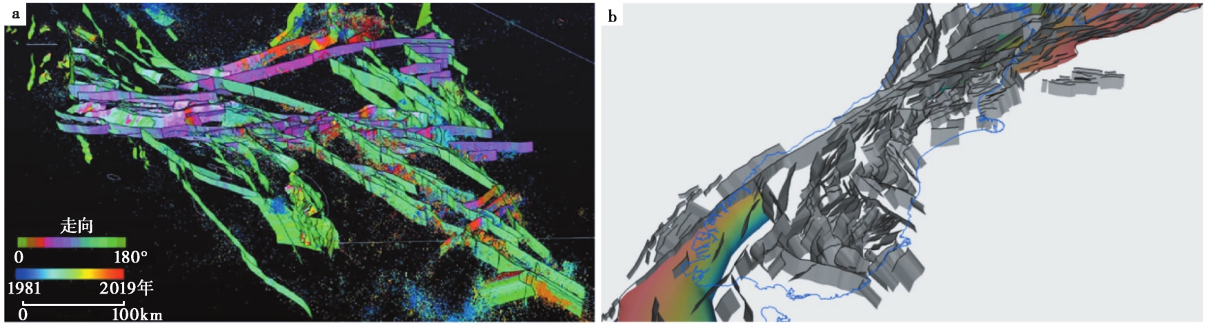
Fig. 1 Three Dimensional Community Fault Model of active faults in southern California and adjacent offshore basins①(a) and New Zealand Community Fault Model②(b). ① https://www.scec.org/。② https://www.gns.cri.nz/。
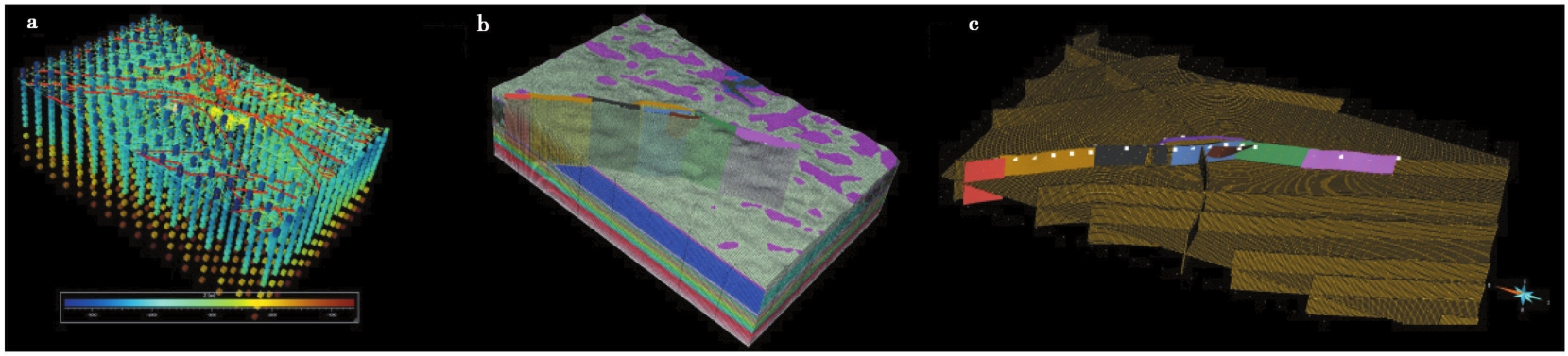
Fig. 2 Integrated modeling based on SKUA-GOCAD.
| [1] |
蔡永恩, 何涛, 王仁. 1999. 1976年唐山地震震源动力过程的数值模拟[J]. 地震学报, 21(5): 467—477.
|
|
|
|
| [2] |
邓志辉, 胡勐乾, 周斌, 等. 2011a. 数值模拟方法在地震预测研究中应用的初步探讨(Ⅱ)[J]. 地震地质, 33(3): 670—683. doi: 10.3969/j.issn.0253-4967.2011.03.016.
|
|
|
|
| [3] |
邓志辉, 宋键, 孙君秀, 等. 2011b. 数值模拟方法在地震预测研究中应用的初步探讨(Ⅰ)[J]. 地震地质, 33(3): 660—669. doi: 10.3969/j.issn.0253-4967.2011.03.015.
|
|
|
|
| [4] |
董培育, 程惠红, 石耀霖, 等. 2019. 基于Monte Carlo方法数值反演区域初始构造应力场: 以巴颜喀拉块体为例[J]. 地球物理学报, 62(8): 2858—2870.
DOI |
|
|
|
| [5] |
董培育, 石耀霖, 程惠红, 等. 2020. 青藏高原及邻区未来地震活动性趋势数值分析[J]. 地球物理学报, 63(3): 1155—1169.
DOI |
|
|
|
| [6] |
李林芳, 石耀霖, 程术. 2022. 长短时记忆神经网络在中期地震预报中的探索: 以川滇地区为例[J]. 地球物理学报, 65(1): 12—25.
DOI |
|
|
|
| [7] |
刘启元, 吴建春. 2003. 论地震数值预测: 关于我国地震预测研究发展战略的思考[J]. 地学前缘, 10(S1): 217—224.
|
|
|
|
| [8] |
鲁人齐, 徐锡伟, 陈立春, 等. 2018. 2017年8月8日九寨沟 MS7.0 地震构造与震区三维断层初始模型[J]. 地震地质, 40(1): 1—11. doi: 10.3969/j.issn.0253-4967.2018.01.001.
|
|
DOI |
|
| [9] |
石耀霖. 2012. 地震数值预报: 飘渺的梦, 还是现实的路?[J]. 科学中国人, (11): 18—25.
|
|
|
|
| [10] |
石耀霖, 胡才博. 2021. 王仁先生在地震预报中的开拓性工作[J]. 地球物理学报, 64(10): 3429—3441.
|
|
|
|
| [11] |
石耀霖, 孙云强, 罗纲, 等. 2018. 关于我国地震数值预报路线图的设想; 汶川地震十周年反思[J]. 科学通报, 63(19): 1865—1881.
|
|
|
|
| [12] |
石耀霖, 张贝, 张斯奇, 等. 2013. 地震数值预报[J]. 物理, 42(4): 237—255.
|
|
|
|
| [13] |
孙云强, 罗纲. 2018. 青藏高原东北缘地震时空迁移的有限元数值模拟[J]. 地球物理学报, 61(6): 2246—2264.
DOI |
|
|
|
| [14] |
唐荣江, 朱守彪. 2020. 不同摩擦本构关系对断层自发破裂动力学过程的影响[J]. 地球物理学报, 63(10): 3712—3726.
DOI |
|
|
|
| [15] |
王妙月, 底青云, 张美根, 等. 1999. 地震孕育、 发生、 发展动态过程的三维有限元数值模拟[J]. 地球物理学报, 42(2): 218—227.
|
|
|
|
| [16] |
王仁. 1994. 有限单元等数值方法在我国地球科学中的应用和发展[J]. 地球物理学报, 37(S1): 128—139.
|
|
|
|
| [17] |
王仁, 何国琦, 殷有泉, 等. 1980. 华北地区地震迁移规律的数学模拟[J]. 地震学报, 2(1): 32—42.
|
|
|
|
| [18] |
王仁, 黄杰藩, 孙荀英, 等. 1982a. 华北地震构造应力场的模拟[J]. 中国科学(B辑), 12(4): 337—344.
|
|
|
|
| [19] |
王仁, 孙荀英, 蔡永恩. 1982b. 华北地区近700年地震序列的数学模拟[J]. 中国科学(B辑), 12(8): 745—753.
|
|
|
|
| [20] |
邢会林, 郭志伟, 王建超, 等. 2022. 断层系统摩擦动力学行为的有限元模拟分析[J]. 地球物理学报, 65(1): 37—50.
DOI |
|
|
|
| [21] |
徐晶, 邵志刚, 马宏生, 等. 2013. 鲜水河断裂带库仑应力演化与强震间关系[J]. 地球物理学报, 56(4): 1146—1158.
|
|
|
|
| [22] |
杨宏峰, 姚素丽, 陈翔. 2022. 非均匀断层上的破裂传播及对震级预测的挑战[J]. 科学通报, 67(13): 1390—1403.
|
|
|
|
| [23] |
姚琪, 王辉, 刘杰, 等. 2023a. 基于数值模拟和地震活动性统计的混合地震预测: 在中国地震科学实验场的应用[J]. 地球物理学报, 66(10): 4162—4175.
|
|
|
|
| [24] |
姚琪, 张盛峰, 王子韬, 等. 2023b. 地震数值预测总体设计导论[M]. 北京: 地震出版社:1—18.
|
|
|
|
| [25] |
尹迪, 董培育, 曹建玲, 等. 2022. 川滇地区地震危险性数值分析[J]. 地球物理学报, 65(5): 1612—1627.
|
|
|
|
| [26] |
袁杰, 崔泽飞, 朱守彪, 等. 2021. 强震孕育, 发生及其复发循环过程的有限单元法模拟[J]. 地球物理学报, 64(2): 537—545.
DOI |
|
|
|
| [27] |
张怀, 吴忠良, 张东宁, 等. 2009. 虚拟川滇: 基于千万网格并行有限元计算的区域强震演化过程数值模型设计和构建[J]. 中国科学(D辑), 39(3): 260—270.
|
|
|
|
| [28] |
DOI URL |
| [29] |
DOI URL |
| [30] |
DOI |
| [31] |
DOI PMID |
| [32] |
DOI URL |
| [33] |
DOI URL |
| [34] |
DOI URL |
| [35] |
DOI URL |
| [36] |
|
| [37] |
DOI |
| [38] |
DOI |
| [39] |
DOI URL |
| [40] |
DOI URL |
| [41] |
DOI URL |
| [42] |
DOI URL |
| [43] |
DOI URL |
| [44] |
DOI |
| [45] |
DOI |
| [46] |
DOI URL |
| [47] |
|
| [48] |
DOI URL |
| [49] |
|
| [50] |
DOI URL |
| [51] |
DOI URL |
| [52] |
|
| [53] |
DOI |
| [54] |
DOI |
| [55] |
|
| [56] |
|
| [57] |
DOI |
| [58] |
|
| [59] |
|
| [60] |
DOI URL |
| [61] |
DOI URL |
| [62] |
DOI URL |
| [63] |
DOI URL |
| [64] |
DOI URL |
| [65] |
DOI URL |
| [66] |
DOI URL |
| [67] |
|
| [68] |
DOI URL |
| [69] |
DOI URL |
| [70] |
|
| [71] |
DOI URL |
| [72] |
DOI URL |
| [73] |
DOI URL |
| [74] |
DOI URL |
| [75] |
|
| [76] |
|
| [77] |
DOI URL |
| [78] |
DOI URL |
| [79] |
DOI URL |
| [80] |
DOI URL |
| [81] |
DOI URL |
| [82] |
|
| [83] |
DOI URL |
| [84] |
DOI |
| [85] |
DOI URL |
| [86] |
DOI URL |
| [87] |
|
| [88] |
|
| [89] |
DOI URL |
| [90] |
DOI URL |
| [91] |
DOI URL |
| [92] |
DOI URL |
| [93] |
DOI URL |
| [94] |
DOI URL |
| [95] |
DOI URL |
| [96] |
DOI URL |
| [97] |
|
| [98] |
DOI URL |
| [99] |
DOI URL |
| [100] |
DOI URL |
| [101] |
DOI URL |
| [102] |
|
| [1] | PANG Zhen-hui, XU Hao-ting, SHI Xu-hua, GE Jin, LI Feng. GEOMORPHIC DATING OF SCARPS AND ITS APPLICATION TO ACTIVE TECTONICS AND GEOMORPHOLOGY [J]. SEISMOLOGY AND GEOLOGY, 2024, 46(2): 251-276. |
| [2] | WANG Hui, CAO Jian-ling, YAO Qi, WANG Li-wei, ZHU Ya-ling. EFFECTS OF STRIKE-SLIP FAULT GEOMETRIC COMPLEXITY ON EARTHQUAKE RUPTURES PROPAGATION: A REVIEW [J]. SEISMOLOGY AND GEOLOGY, 2024, 46(1): 201-219. |
| [3] | GUO Ting-ting, XU Xi-wei, YUAN Ren-mao, YANG Hong-zhi. NUMERICAL SIMULATION OF INFLUENCING FACTORS OF SURFACE RUPTURE IN OVERLYING SOIL LAYER OF THRUST FAULT [J]. SEISMOLOGY AND GEOLOGY, 2023, 45(5): 1200-1218. |
| [4] | XU Zhi-guo, WANG Jun-cheng, WANG Zong-chen, LIANG Shan-shan, SHI Jian-yu. FOCAL MECHANISM AND TSUNAMI NUMERICAL SIMULATION OF THE NOVEMBER 14, 2019 MOLUCCA SEA MW7.1 EARTHQUAKE [J]. SEISMOLOGY AND GEOLOGY, 2020, 42(6): 1417-1431. |
| [5] | SHI Feng, HE Hong-lin, ZHOU Ben-gang, WEI Zhan-yu, BI Li-si. EFFECT OF TSUNAMIS GENERATED IN THE MANILA TRENCH ON CHINA MAINLAND [J]. SEISMOLOGY AND GEOLOGY, 2018, 40(3): 579-589. |
| [6] | WAN Yong-kui, LIU Xia, SHEN Jun, WANG Lei, LI Yan. NUMERICAL SIMULATION OF DEFORMATION MOVEMENT AND STRESS ACCUMULATION IN LONGMENSHAN AND ITS ADJACENT FAULTS BEFORE WENCHUAN EARTHQUAKE [J]. SEISMOLOGY AND GEOLOGY, 2017, 39(4): 853-868. |
| [7] | YANG Shao-hua, REN Tian-xiang, DONG Pei-yu, SHI Yao-lin. INTERPRETATION OF BOREHOLE STRAIN ANNUAL CHANGE AT GUZAN STATION BY NUMERICAL SIMULATION [J]. SEISMOLOGY AND GEOLOGY, 2016, 38(4): 1137-1147. |
| [8] | DONG Pei-yu, HU Cai-bo, SHI Yao-lin. NUMERICAL SIMULATION OF LONG-TERM DEFORMATION OF TIBETAN PLATEAU AND SURROUNDING AREA [J]. SEISMOLOGY AND GEOLOGY, 2016, 38(2): 410-422. |
| [9] | YIN Jing-yuan, LIU Lan, WANG Hua-lin, LI Cheng-fan. THE RESEARCH ON THE IMPACT OF DISPLACEMENT FIELD OF JAPAN 3·11 EARTHQUAKE ON THE SOUTH CENTRAL SECTION OF TANLU FAULT ZONE [J]. SEISMOLOGY AND GEOLOGY, 2015, 37(3): 928-938. |
| [10] | YANG Yu, YANG Xiao-song, DUAN Qing-bao. NUMERICAL SIMULATION OF TEMPORAL-SPATIAL DISTRIBUTION OF PORE-FLUID PRESSURE INDUCED BY ZIPINGPU RESERVOIR IMPOUNDMENT [J]. SEISMOLOGY AND GEOLOGY, 2015, 37(2): 510-523. |
| [11] | CHEN Xiao-li, CHANG Zu-feng, WANG Kun. NUMERICAL SIMULATION STUDY OF HONGSHIYAN LANDSLIDE TRIGGERED BY THE MS6.5 LUDIAN EARTHQUAKE [J]. SEISMOLOGY AND GEOLOGY, 2015, 37(1): 279-290. |
| [12] | ZHOU Bin, SUN Feng, XUE Shi-feng, JIANG Hai-kun, SHI Shui-ping. NUMERICAL SIMULATION ON THE CHANGES OF ELASTIC WAVE VELOCITIES OF ROCKS UNDER RESERVOIR BOTTOM DURING WATER STORAGE AND DRAINAGE [J]. SEISMOLOGY AND GEOLOGY, 2014, 36(1): 39-51. |
| [13] | DENG Zhi-hui, SONG Jian, SUN Jun-xiu, TAO Jing-ling, HU Meng-qian, MA Xiao-jing, JIANG Hui, LI Hong. PRELIMINARY STUDY ON APPLICATION OF NUMERICAL SIMULATION METHODS TO EARTHQUAKE PREDICTION RESEARCH(Ⅰ) [J]. SEISMOLOGY AND GEOLOGY, 2011, 33(3): 660-669. |
| [14] | DENG Zhi-hui, HU Meng-qian, ZHOU Bin, LU Yuan-zhong, TAO Jing-ling, MA Xiao-jing, JIANG Hui, LI Hong. PRELIMINARY STUDY ON APPLICATION OF NUMERICAL SIMU-LATION METHODS TO EARTHQUAKE PREDICTION RESEARCH(Ⅱ) [J]. SEISMOLOGY AND GEOLOGY, 2011, 33(3): 670-683. |
| [15] | HU Meng-qian, DENG Zhi-hui, LU Yuan-zhong. ADVANCES IN APPLICATION OF FINITE ELEMENT NUMERICAL SIMULATION TO SEISMOGEOLOGY IN NORTH CHINA [J]. SEISMOLOGY AND GEOLOGY, 2010, 32(1): 162-173. |
| Viewed | ||||||
|
Full text |
|
|||||
|
Abstract |
|
|||||
