
SEISMOLOGY AND GEOLOGY ›› 2026, Vol. 48 ›› Issue (1): 127-141.DOI: 10.3969/j.issn.0253-4967.20240086
• Research pape • Previous Articles Next Articles
AZIMUTHAL ANISOTROPY OF THE MIDDLE-UPPER CRUST IN NORTHWESTERN YUNNAN BY DIRECT SURFACE WAVE TOMOGRAPHY METHOD
YANG Jian-wen1,2)( ), LI Qing1,2), YE Beng1,2),*(), JIN Ming-pei1,2), CHA Wen-jian1,2), JIA Luo-zhao1,2)
- 1)
Yunnan Earthquake Agency
2)Field Scientific Observation and Research Station on Crustal Tectonic Activities in Northwest Yunnan
-
Received:2025-07-09Revised:2025-12-19Online:2026-02-20Published:2026-03-14
利用面波直接成像方法研究滇西北中上地壳方位各向异性
杨建文1,2)(), 李庆1,2), 叶泵1,2),*(), 金明培1,2), 茶文剑1,2), 贾漯昭1,2)
- 1)
云南省地震局
2)云南大理滇西北地壳构造活动野外科学观测研究站
-
通讯作者:* 叶泵, 男, 1984年生, 高级工程师, 主要从事精细结构与孕震环境研究, E-mail: 258674348@qq.com。 -
作者简介:杨建文, 男, 1989年生, 2014年于昆明理工大学获测绘工程专业硕士学位, 高级工程师, 主要从事精细结构与孕震环境研究工作, E-mail: 928547602@qq.com。
-
基金资助:云南省地震局地震科技专项基金(2023ZX01); 云南省地震科技创新团队(CXTD202506); 中国地震局地震科技星火计划项目(XH25016A); 中国地震局地震科技星火计划项目(XH23034YA)共同资助)
Cite this article
YANG Jian-wen, LI Qing, YE Beng, JIN Ming-pei, CHA Wen-jian, JIA Luo-zhao. AZIMUTHAL ANISOTROPY OF THE MIDDLE-UPPER CRUST IN NORTHWESTERN YUNNAN BY DIRECT SURFACE WAVE TOMOGRAPHY METHOD[J]. SEISMOLOGY AND GEOLOGY, 2026, 48(1): 127-141.
杨建文, 李庆, 叶泵, 金明培, 茶文剑, 贾漯昭. 利用面波直接成像方法研究滇西北中上地壳方位各向异性[J]. 地震地质, 2026, 48(1): 127-141.
share this article
Add to citation manager EndNote|Ris|BibTeX
URL: https://www.dzdz.ac.cn/EN/10.3969/j.issn.0253-4967.20240086
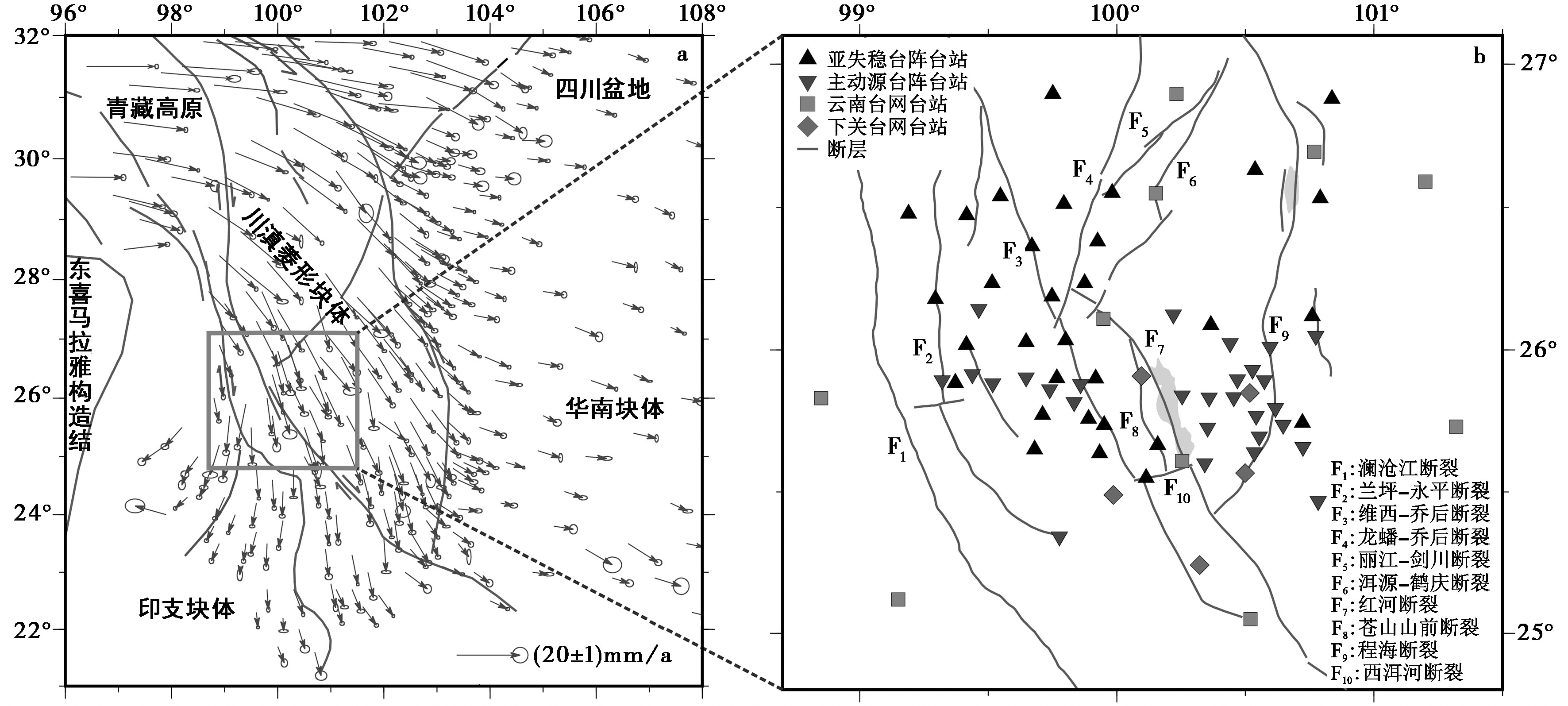
Fig. 1 Tectonic background of the study area(a); Distribution of faults and stations of the study area(b).
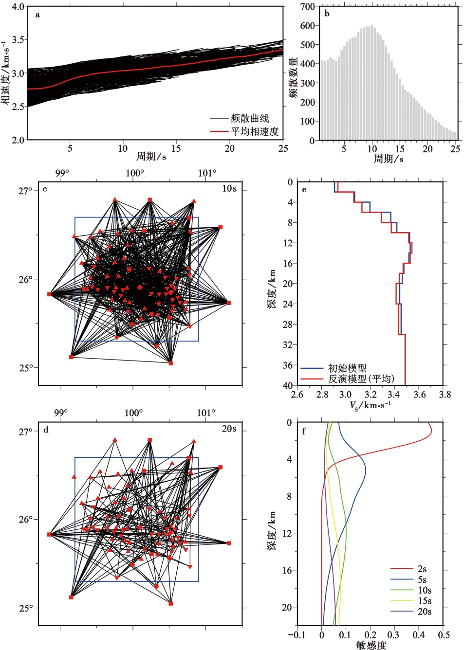
Fig. 2 Rayleigh wave phase velocity dispersion, ray path coverage, comparison of average one-dimensional S-wave velocity models obtained by initial and inversion, and phase velocity depth sensitive kernel in the study area.
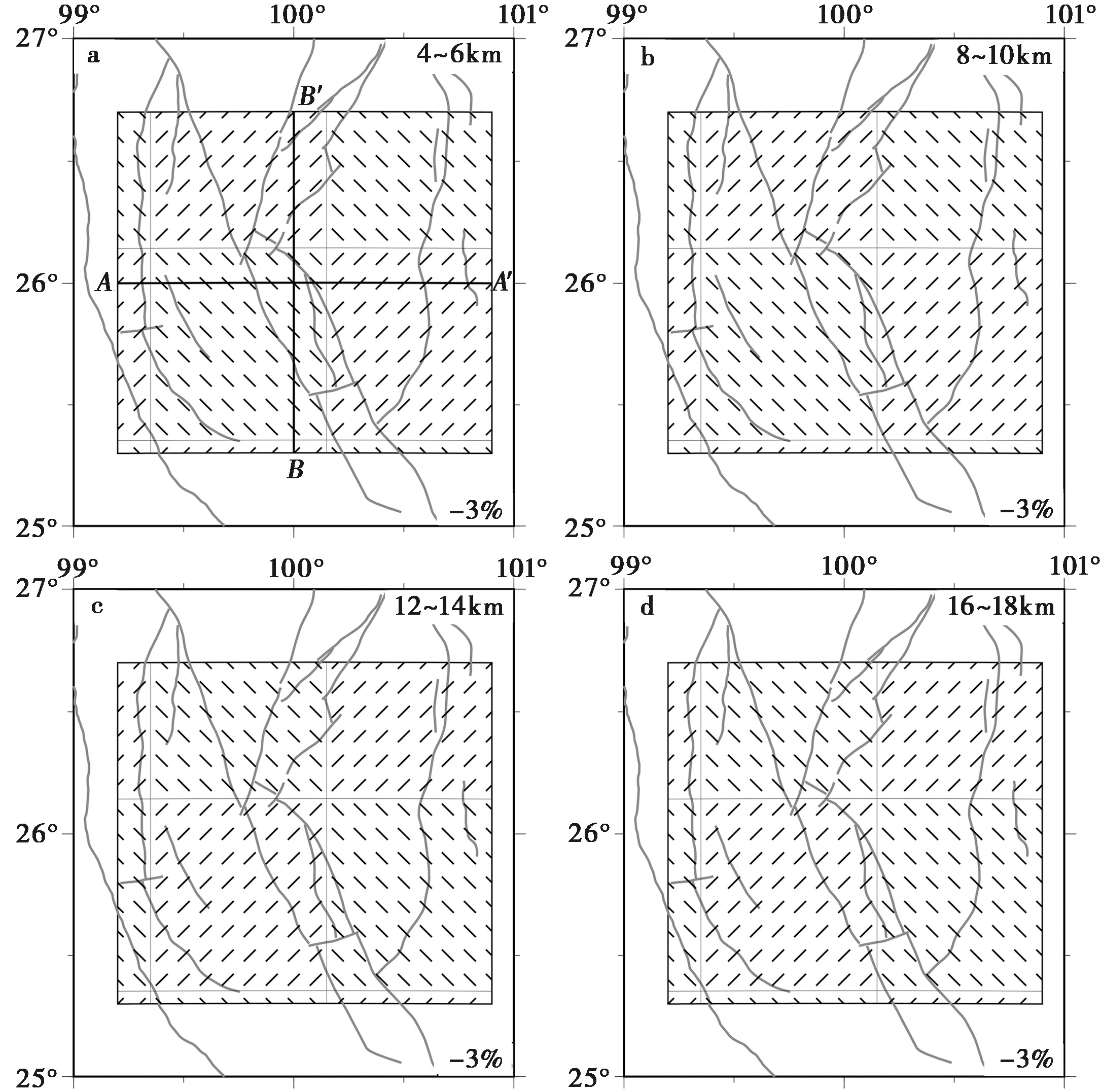
Fig. 3 Input model of azimuthal anisotropy detection plate in different depth ranges.
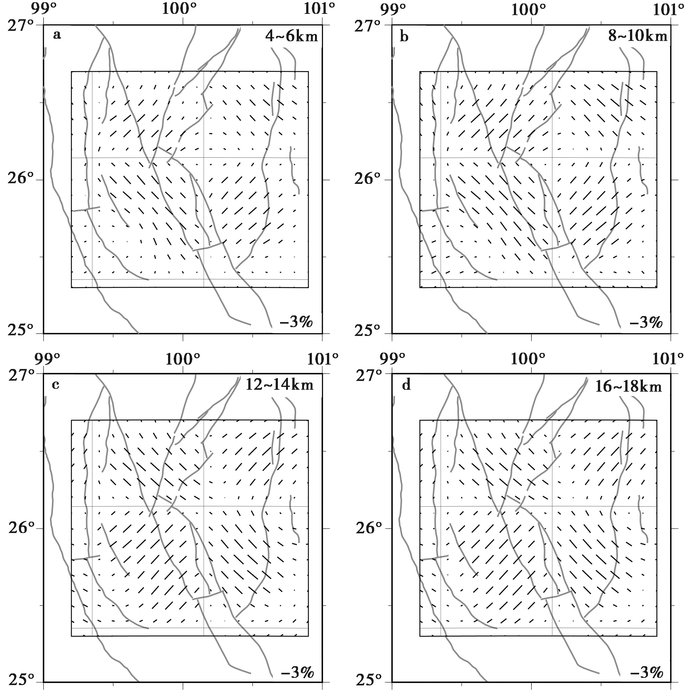
Fig. 4 Recovery model of azimuthal anisotropy detection plate in different depth ranges.
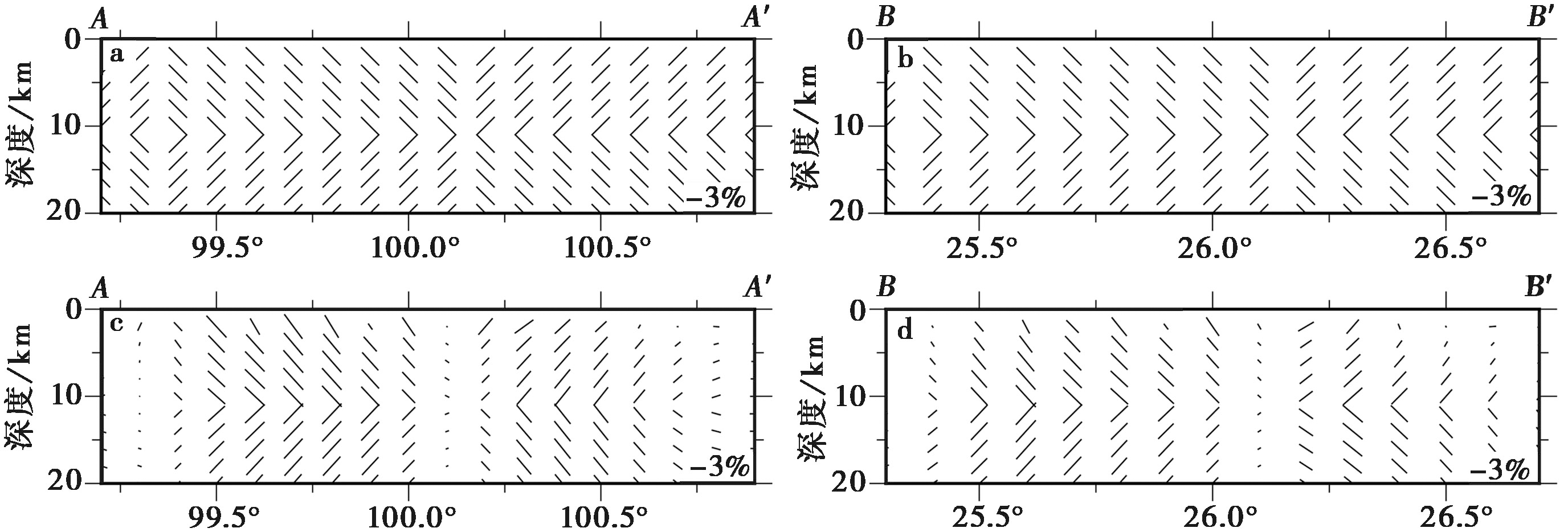
Fig. 5 Test results of azimuthal anisotropy detection plates of two vertical sections.
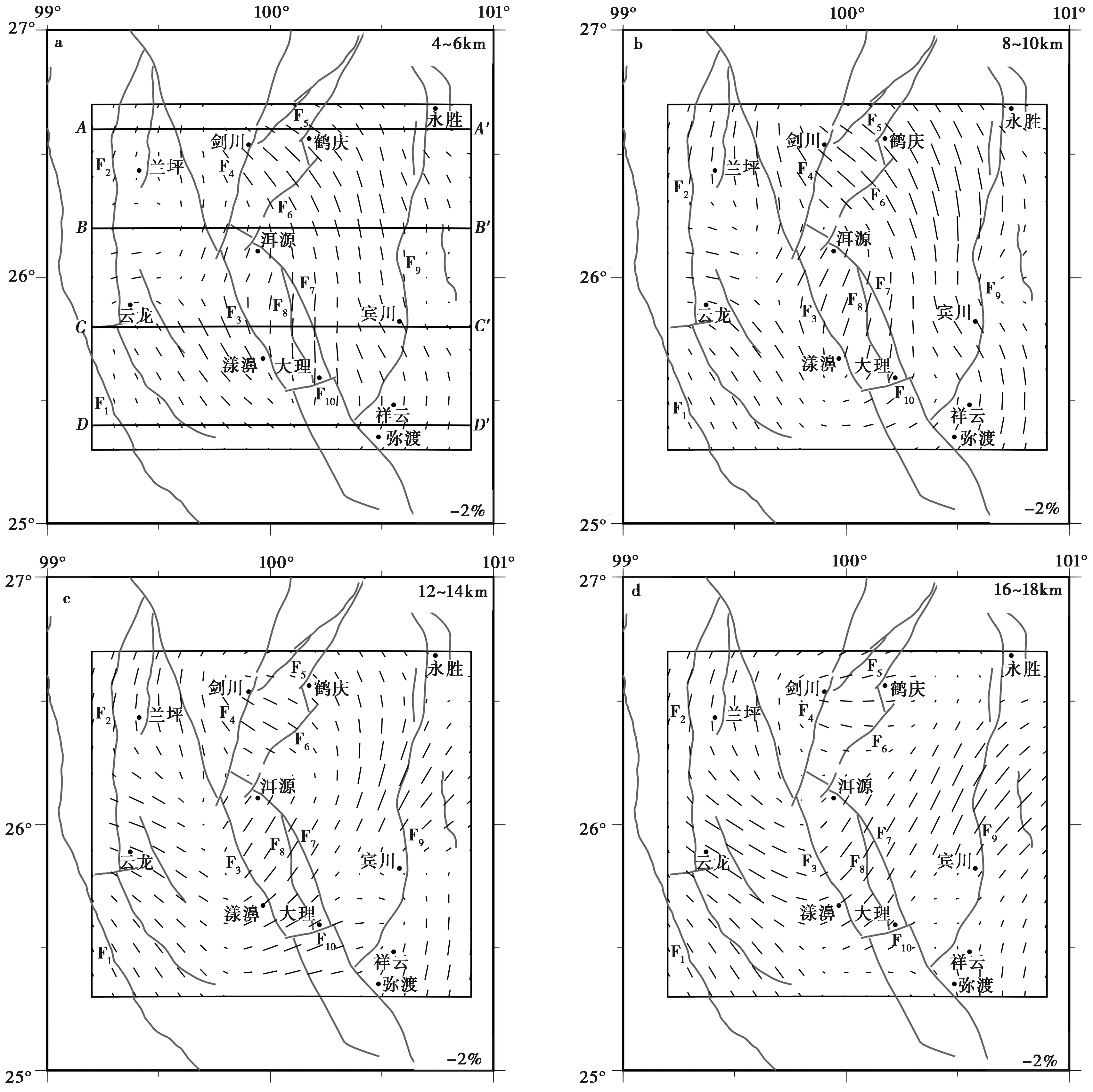
Fig. 6 Azimuthal anisotropy horizontal profiles at different depths in the study area.
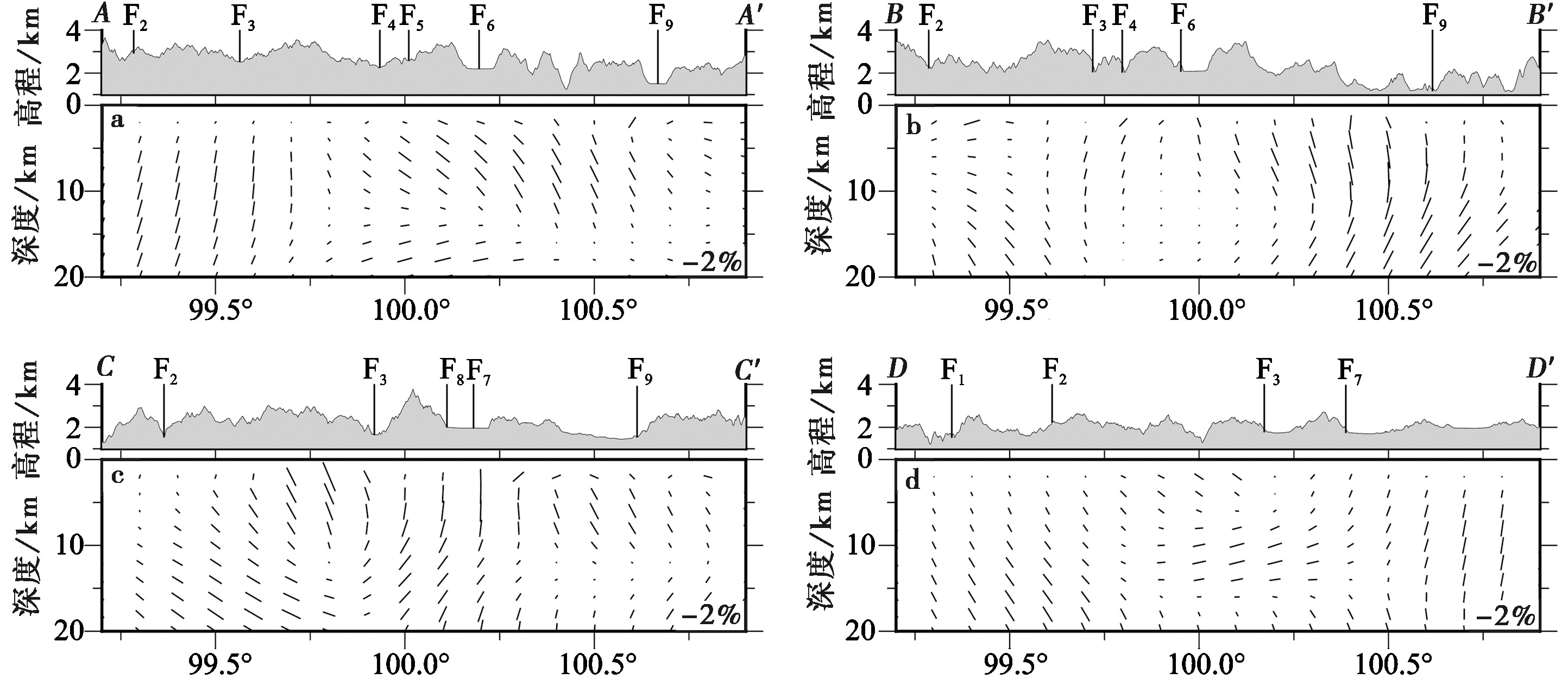
Fig. 7 Vertical section showing azimuthal anisotropy in the study area.
| [1] |
常祖峰, 常昊, 李鉴林, 等. 2016a. 维西-乔后断裂南段正断层活动特征[J]. 地震研究, 39(4): 579—586.
|
|
|
|
| [2] |
常祖峰, 常昊, 臧阳, 等. 2016b. 维西-乔后断裂新活动特征及其与红河断裂的关系[J]. 地质力学学报, 22(3): 517—530.
|
|
|
|
| [3] |
崔华伟, 郑建常, 万永革, 等. 2022. 2021年云南漾濞 MS6.4 地震序列发震构造及其与2013年洱源、2017年漾濞地震的异同[J]. 地球物理学报, 65(2): 620—636.
|
|
|
|
| [4] |
樊文杰, 崔效锋, 赵小艳. 2022. 滇西北地区现今构造应力状态及其与地震的关系[J]. 地震学报, 44(4): 632—643.
|
|
|
|
| [5] |
黄周传, 吉聪, 吴寒婷, 等. 2021. 青藏高原东南缘地壳结构与变形机制研究进展[J]. 地球与行星物理论评, 52(3): 291—307.
|
|
|
|
| [6] |
靳佳琪. 2022. 郯庐断裂带潍坊段地壳浅层速度结构及变形特征研究[D]. 合肥: 中国科学技术大学:25—27.
|
|
|
|
| [7] |
靳佳琪, 罗松, 姚华建, 等. 2023. 密集台阵背景噪声成像揭示郯庐断裂带潍坊段地壳浅层速度结构及变形特征[J]. 地球物理学报, 66(2): 558—575.
|
|
|
|
| [8] |
李玲利, 黄显良, 姚华建, 等. 2020. 合肥市地壳浅部三维速度结构及城市沉积环境初探[J]. 地球物理学报, 63(9): 3307—3323.
|
|
|
|
| [9] |
鲁来玉, 何正勤, 丁志峰, 等. 2014. 基于背景噪声研究云南地区面波速度非均匀性和方位各向异性[J]. 地球物理学报, 57(3): 822—836.
|
|
|
|
| [10] |
孟亚锋, 姚华建, 王行舟, 等. 2019. 基于背景噪声成像方法研究郯庐断裂带中南段及邻区地壳速度结构与变形特征[J]. 地球物理学报, 62(7): 2490—2509.
|
|
|
|
| [11] |
钱晓东, 秦嘉政, 刘丽芳. 2011. 云南地区现代构造应力场研究[J]. 地震地质, 33(1): 91—106. doi: 10.3969/j.issn.0253-4967.2011.0.009.
|
|
|
|
| [12] |
孙长青, 雷建设, 李聪, 等. 2013. 云南地区地壳各向异性及其动力学意义[J]. 地球物理学报, 56(12): 4095—4105.
|
|
|
|
| [13] |
王一咪, 徐龙辉, 杨海燕, 等. 2023. 维西-乔后断裂带的深部变形机制与构造活动特征[J]. 地球物理学报, 66(3): 1070—1085.
|
|
|
|
| [14] |
王月, 胡少乾, 何骁慧, 等. 2021. 2021年5月21日云南漾濞6.4级地震序列重定位及震源机制研究[J]. 地球物理学报, 64(12): 4510—4525.
|
|
|
|
| [15] |
吴鹏, 高原, 陈安国, 等. 2020. 青藏高原东南缘三江地区上地壳各向异性初步研究[J]. 地球物理学报, 63(3): 1104—1116.
|
|
|
|
| [16] |
杨建文, 金明培, 叶泵, 等. 2025. 基于背景噪声成像方法研究滇西北中上地壳三维速度结构及孕震环境[J]. 地震地质, 47(4): 1113—1131. doi: 10.3969/j.issn.0253-4967.2025.04.20240011.
|
|
|
|
| [17] |
姚华建, 罗松, 李成, 等. 2023. 基于面波走时的三维结构面波直接成像: 方法综述与应用[J]. 地球与行星物理论评, 54(3): 231—251.
|
|
|
|
| [18] |
|
| [19] |
|
| [20] |
|
| [21] |
|
| [22] |
|
| [23] |
|
| [24] |
|
| [25] |
|
| [26] |
DOI URL |
| [27] |
DOI URL |
| [28] |
|
| [29] |
|
| [30] |
|
| [1] | YANG Jian-wen, JIN Ming-pei, YE Beng, CHA Wen-jian, HEI He-tang. THREE-DIMENSIONAL VELOCITY STRUCTURE AND SEI-SMOGENIC ENVIRONMENT IN THE MIDDLE AND UPPER CRUST OF NORTHWEST YUNNAN FROM AMBIENT NOISE TOMOGRAPHY [J]. SEISMOLOGY AND GEOLOGY, 2025, 47(4): 1113-1131. |
| [2] | LI Ruo-hao, LEI Jian-she, SONG Xiao-yan. 3-D CRUSTAL S-WAVE VELOCITY STRUCTURE IN AND AROUND THE DATONG VOLCANIC GROUP: CONSTRAINTS FROM DIRECT TOMOGRAPHIC IMAGING OF AMBIENT-NOISE SURFACE WAVES [J]. SEISMOLOGY AND GEOLOGY, 2025, 47(4): 1090-1112. |
| [3] | HUA Qian, PEI Shun-ping, LI Tao, LIU Han-lin, LIU Wei, LI Lei, LI Jia-wei, YANG Yi-hai. HIGH-RESOLUTION SHALLOW CRUSTAL S-WAVE VELOCITY STRUCTURE IMAGING IN THE KASHGAR, XINJIANG [J]. SEISMOLOGY AND GEOLOGY, 2025, 47(2): 533-546. |
| [4] | JI Yu, ZHANG Guang-wei, REN Jun-jie, HE Jing, WANG Xiao-wei. HIGH-RESOLUTION S-WAVE VELOCITY STRUCTURE OF BEIJING AREA USING AMBIENT NOISE TOMOGRAPHY [J]. SEISMOLOGY AND GEOLOGY, 2025, 47(1): 306-324. |
| [5] | ZHANG Tian-ji, LI Qiu-feng, LI Feng-ying, ZHONG Yu-sheng, DUAN Hong-jie. THE STUDY OF CRUSTAL THICKNESS AND POISSON'S RATIO IN TENGCHONG VOLCANO AREA BY H-к-c METHOD [J]. SEISMOLOGY AND GEOLOGY, 2024, 46(5): 1048-1065. |
| [6] | ZHOU Ming, DUAN Yong-hong, TAN Yu-juan, QIU Yong. THE 3-D SHALLOW VELOCITY STRUCTURE OF THE MIDDLE-NORTH SECTION OF THE DONGPU DEPRESSION DERIVED FROM DENSE ARRAY OBSERVATIONS OF AMBIENT NOISE [J]. SEISMOLOGY AND GEOLOGY, 2023, 45(2): 517-535. |
| [7] | GONG Meng, LÜ Jian, ZHENG Yong, XIE Zu-jun, SHENG Shu-zhong, ZHANG Xing-mian. THREE-DIMENSIONAL S-WAVE VELOCITY DISTRIBUTION BASED ON AMBIENT NOISE ANALYSIS IN SOUTH CHINA BLOCK AND ITS ADJACENT AREAS [J]. SEISMOLOGY AND GEOLOGY, 2022, 44(4): 1011-1028. |
| [8] | GU Qin-ping, KANG Qing-qing, ZHANG Peng, MENG Ke, WU Shan-shan, LI Zheng-kai, WANG Jun-fei, HUANG Qun, JIANG Xin, LI Da-hu. RAYLEIGH WAVE PHASE VELOCITY AND AZIMUTHAL ANISOTROPY OF THE MIDDLE-SOUTHERN SEGMENT OF THE TAN-LU FAULT ZONE AND ADJACENT REGIONS FROM AMBIENT NOISE TOMOGRAPHY [J]. SEISMOLOGY AND GEOLOGY, 2020, 42(5): 1129-1152. |
| [9] | KONG Xiang-yan, WU Jian-ping, FANG Li-hua, CAI Yan, FAN Li-ping, WANG Wei-lai. JOINT INVERSION OF SURFACE WAVE DISPERSION AND RECEIVER FUNCTIONS FOR CRUSTAL AND UPPERMOST MANTLE STRUCTURE BENEATH CHINESE TIENSHAN AND ITS ADJACENT AREAS [J]. SEISMOLOGY AND GEOLOGY, 2020, 42(4): 844-865. |
| [10] | ZONG Jian-ye, SUN Xin-lei, ZHANG Peng. SITE EFFECT AND EARTHQUAKE DISASTER CHARACTERISTICS IN GUANGZHOU AREA FROM HORIZONTAL-TO-VERTICAL SPECTRAL RATIO(HVSR)METHOD [J]. SEISMOLOGY AND GEOLOGY, 2020, 42(3): 628-639. |
| [11] | FENG Hong-wu, YAN Wen-hua, YAN Shan, GUO Ying-xia, HUI Shao-xing, CHANG Cheng. JOINT INVERSION OF AMBIENT NOISE AND SURFACE WAVE FOR S-WAVE VELOCITY OF THE CRUST AND UPPERMOST MANTLE BENEATH WEIHE BASIN AND ITS ADJACENT AREA [J]. SEISMOLOGY AND GEOLOGY, 2019, 41(5): 1185-1205. |
| [12] | XIONG Cheng, XIE Zu-jun, ZHENG Yong, XIONG Xiong, AI San-xi, XIE Ren-xian. RAYLEIGH WAVE TOMOGRAPHY IN THE CRUST AND UPPER MANTLE OF THE DABIE-TANLU OROGENIC ZONE [J]. SEISMOLOGY AND GEOLOGY, 2019, 41(1): 1-20. |
| [13] | GONG Meng, XU Xi-wei, ZHANG Xin-dong, OUYANG Long-bin, JIANG Guo-yan, DONG Bo. THREE-DIMENSIONAL S-WAVE VELOCITY DISTRIBUTION BASED ON AMBIENT NOISE ANALYSIS IN EASTERN NORTH [J]. SEISMOLOGY AND GEOLOGY, 2017, 39(1): 130-146. |
| [14] | XIE Xiao-feng, YANG Wei, LI Jun, LIN Jian-min, WANG Wei-tao, YAO Lin, LÜ Jun-qiang. ANALYSIS ON THE SEASONAL VARIATION OF THE AZIMUTH AND STRENGTH OF AMBIENT NOISE ENERGY IN NINGXIA AND ITS ADJACENT REGION [J]. SEISMOLOGY AND GEOLOGY, 2014, 36(1): 80-89. |
| Viewed | ||||||
|
Full text |
|
|||||
|
Abstract |
|
|||||
Copyright © SEISMOLOGY AND GEOLOGY, All Rights Reserved.
Tel: 010-62009049/9063 E-mail: dzdz@ies.ac.cn
Powered by Beijing Magtech Co., Ltd.