
SEISMOLOGY AND GEOLOGY ›› 2026, Vol. 48 ›› Issue (2): 497-519.DOI: 10.3969/j.issn.0253-4967.20240139
• Research paper • Previous Articles Next Articles
LANDSLIDE SUSCEPTIBILITY ASSESSMENT OF THE 2014 LUDIAN EARTHQUAKE: COMPARATIVE STUDY BASED ON CONVOLUTIONAL NEURAL NETWORK AND RANDOM FOREST
WANG Wan-tong1,2,3)( ), MA Si-yuan1,2), YAN Wu-jian3), YUAN Ren-mao1,2),*()
- 1)
Institute of Geology ,China Earthquake Administration
2)Key Laboratory of Seismic and Volcanic Hazards ,Institute of Geology, China Earthquake Administration
3)Lanzhou Institute of Seismology ,China Earthquake Administration
-
Received:2025-01-21Revised:2025-03-15Online:2026-04-20Published:2026-05-14 -
Contact:YUAN Ren-mao
2014年 MW6.2 鲁甸地震滑坡易发性评估:基于卷积神经网络与随机森林算法的对比
王莞瞳1,2,3)(), 马思远1,2), 严武建3), 袁仁茂1,2),*()
- 1)
中国地震局地质研究所
2)中国地震局地质研究所 ,地震与火山灾害重点实验室
3)中国地震局兰州地震研究所
-
通讯作者:袁仁茂 -
作者简介:王莞瞳, 女, 1989年生, 2025年于中国地震局兰州地震研究所获理学硕士学位, 研究方向为地震地质灾害, E-mail: wwt@ies.ac.cn。
-
基金资助:国家自然科学基金(42330704); 中国地震局地震科技星火计划攻关项目(XH24044A)
Cite this article
WANG Wan-tong, MA Si-yuan, YAN Wu-jian, YUAN Ren-mao. LANDSLIDE SUSCEPTIBILITY ASSESSMENT OF THE 2014 LUDIAN EARTHQUAKE: COMPARATIVE STUDY BASED ON CONVOLUTIONAL NEURAL NETWORK AND RANDOM FOREST[J]. SEISMOLOGY AND GEOLOGY, 2026, 48(2): 497-519.
王莞瞳, 马思远, 严武建, 袁仁茂. 2014年 MW6.2 鲁甸地震滑坡易发性评估:基于卷积神经网络与随机森林算法的对比[J]. 地震地质, 2026, 48(2): 497-519.
share this article
Add to citation manager EndNote|Ris|BibTeX
URL: https://www.dzdz.ac.cn/EN/10.3969/j.issn.0253-4967.20240139
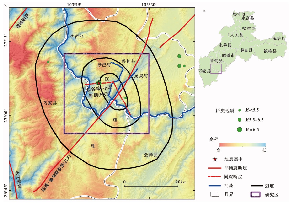
Fig. 1 Map showing the geographical location of study area(a), and the elevation, historical earthquakes, and tectonic setting of study area(b).
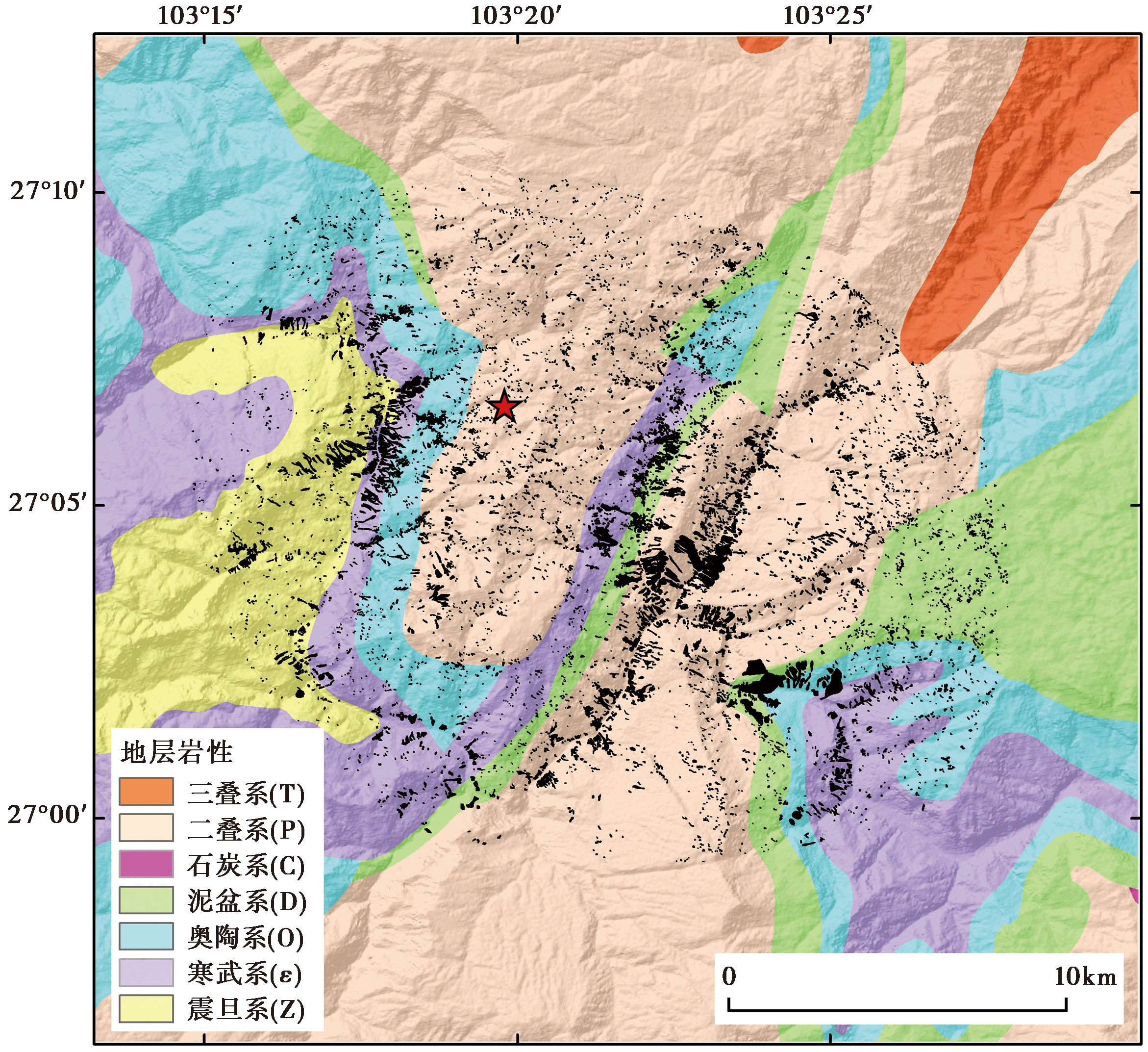
Fig. 2 Lithology distribution of the study area.
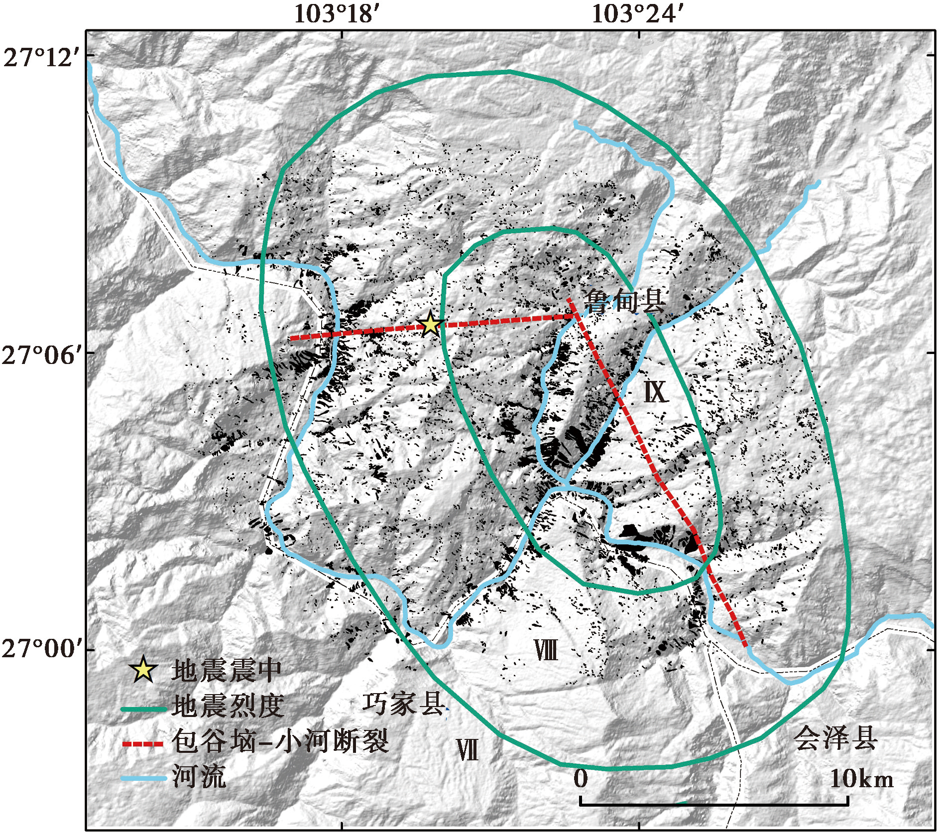
Fig. 3 The distribution of coseismic landslides triggered by the 2014 Ludian earthquake.
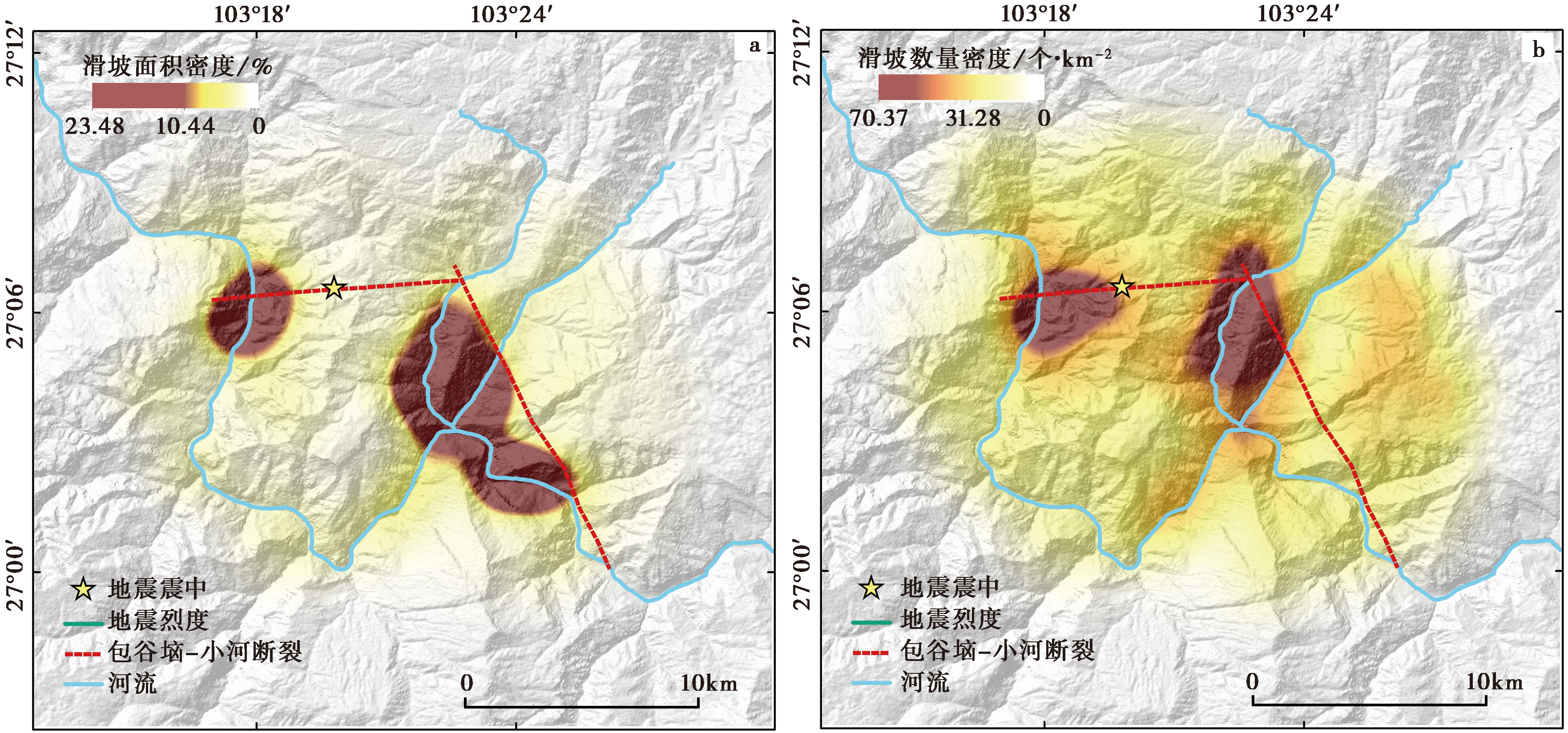
Fig. 4 The distribution characteristics of landslide in the study area.
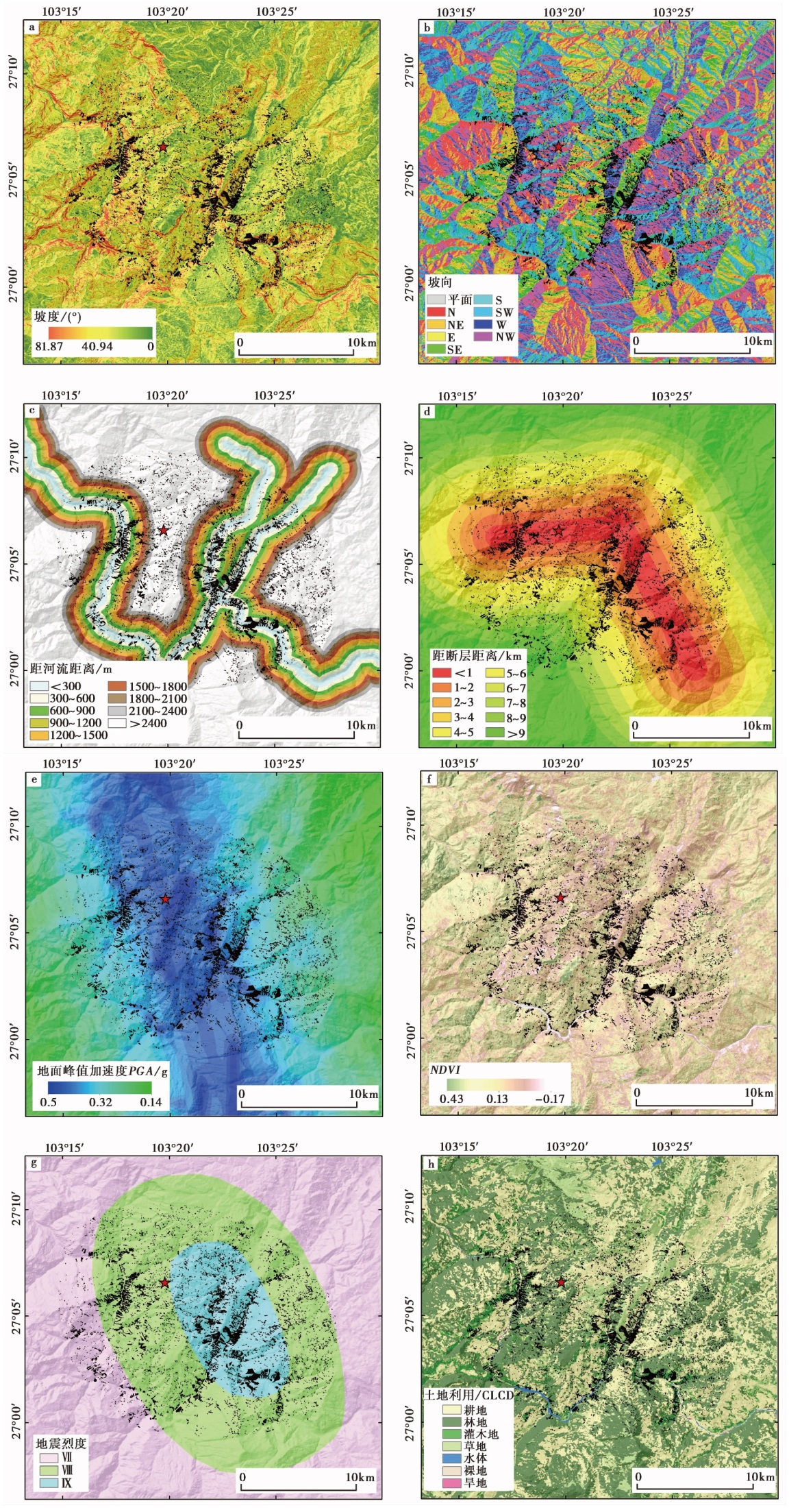
Fig. 5 The distribution of the influencing factors in the study area.
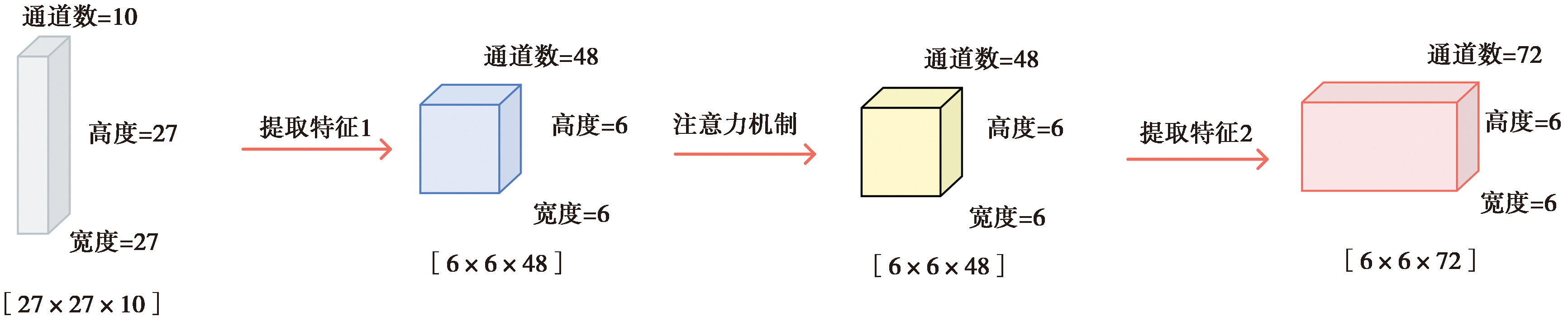
Fig. 6 Diagram showing the principle of AlexNetCBAM model.
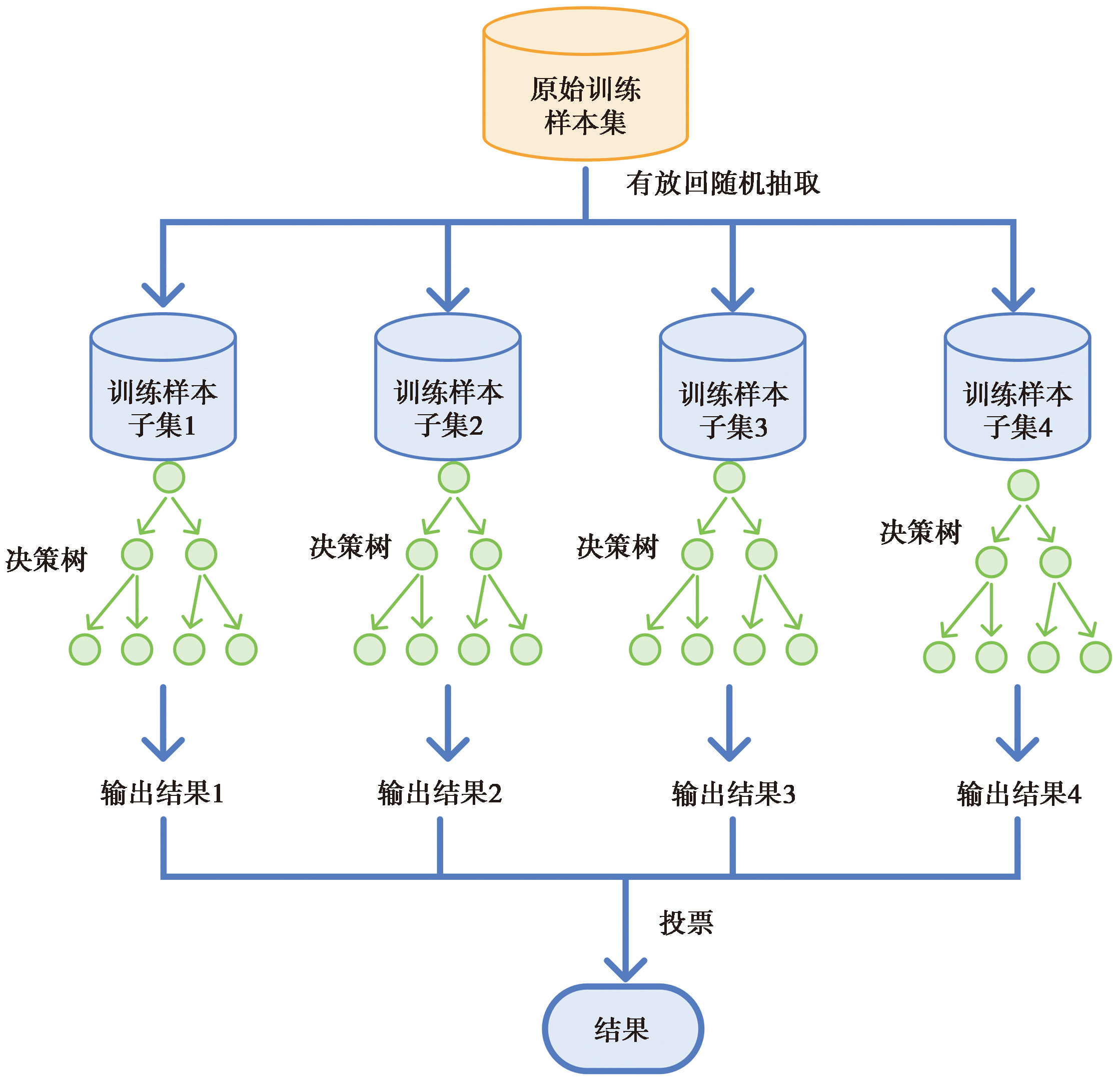
Fig. 7 Schematic diagram of the random forest model.
| 影响因子 | 重要性(GINI) | VIF |
|---|---|---|
| 与断层的距离 | 0.222 | 2.856 |
| 地震烈度 | 0.216 | 3.018 |
| PGA | 0.132 | 1.821 |
| 与河流的距离 | 0.111 | 3.405 |
| NDVI | 0.088 | 2.273 |
| 高程 | 0.074 | 3.194 |
| 坡度 | 0.052 | 1.250 |
| 地层岩性 | 0.039 | 2.131 |
| 坡向 | 0.037 | 1.031 |
| 土地利用 | 0.029 | 1.076 |
Table 1 VIF value and GI value of the influencing factors
| 影响因子 | 重要性(GINI) | VIF |
|---|---|---|
| 与断层的距离 | 0.222 | 2.856 |
| 地震烈度 | 0.216 | 3.018 |
| PGA | 0.132 | 1.821 |
| 与河流的距离 | 0.111 | 3.405 |
| NDVI | 0.088 | 2.273 |
| 高程 | 0.074 | 3.194 |
| 坡度 | 0.052 | 1.250 |
| 地层岩性 | 0.039 | 2.131 |
| 坡向 | 0.037 | 1.031 |
| 土地利用 | 0.029 | 1.076 |
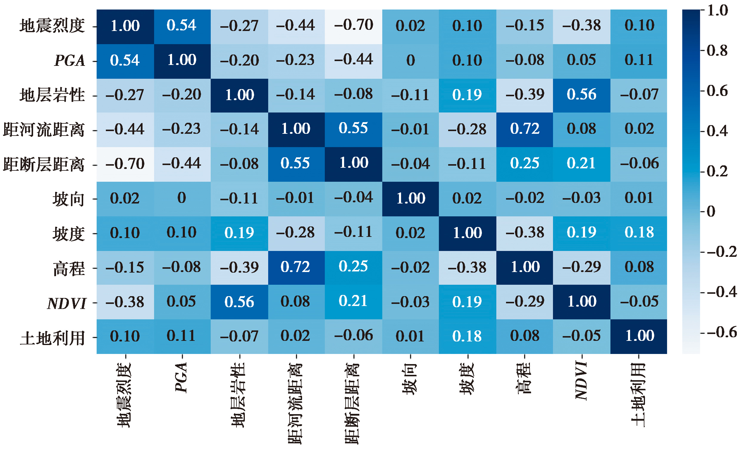
Fig. 8 The correlation coefficient matrix for the influencing factors.

Fig. 9 The predicted results of the occurrence probability of landslides based on two different models.
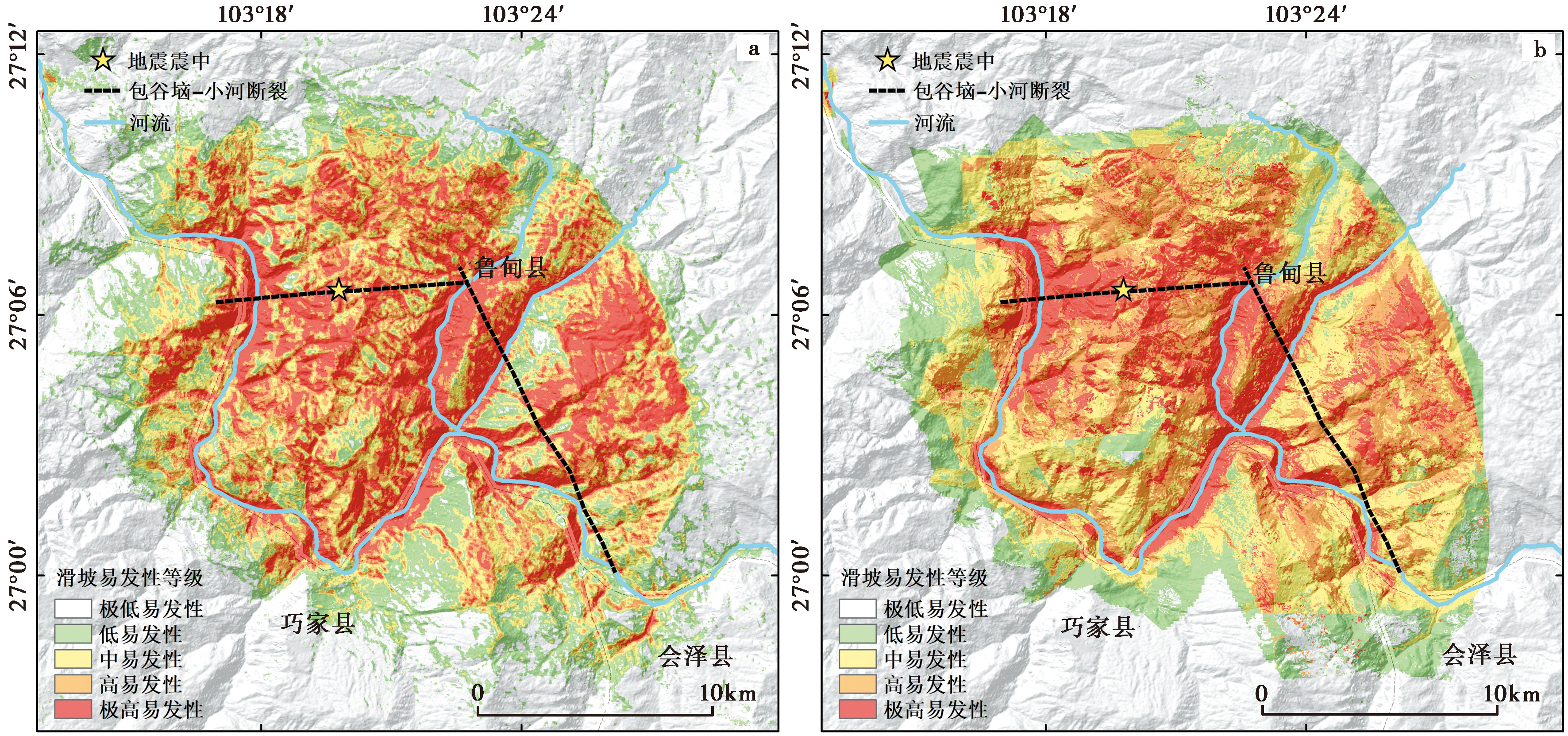
Fig. 10 Map of landslides susceptibility class for two different models using AlexNetCBAM.
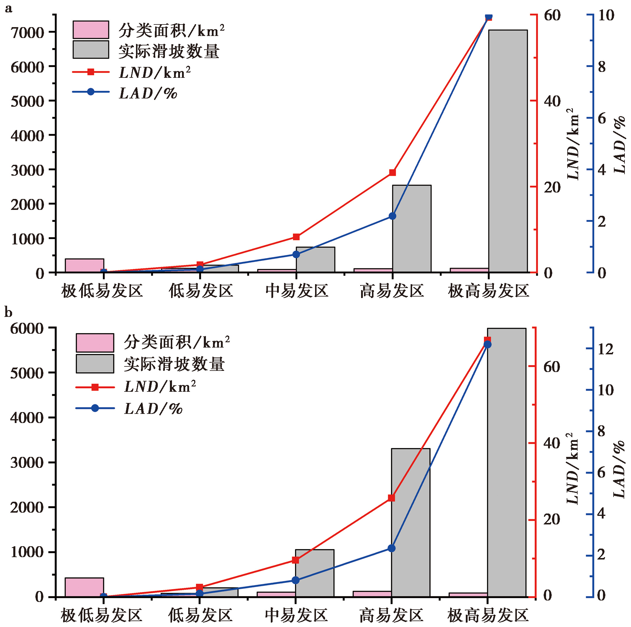
Fig. 11 The statistical result of the predicted area and LND, LAD, landslide number under the landslides susceptibility class for two different models.
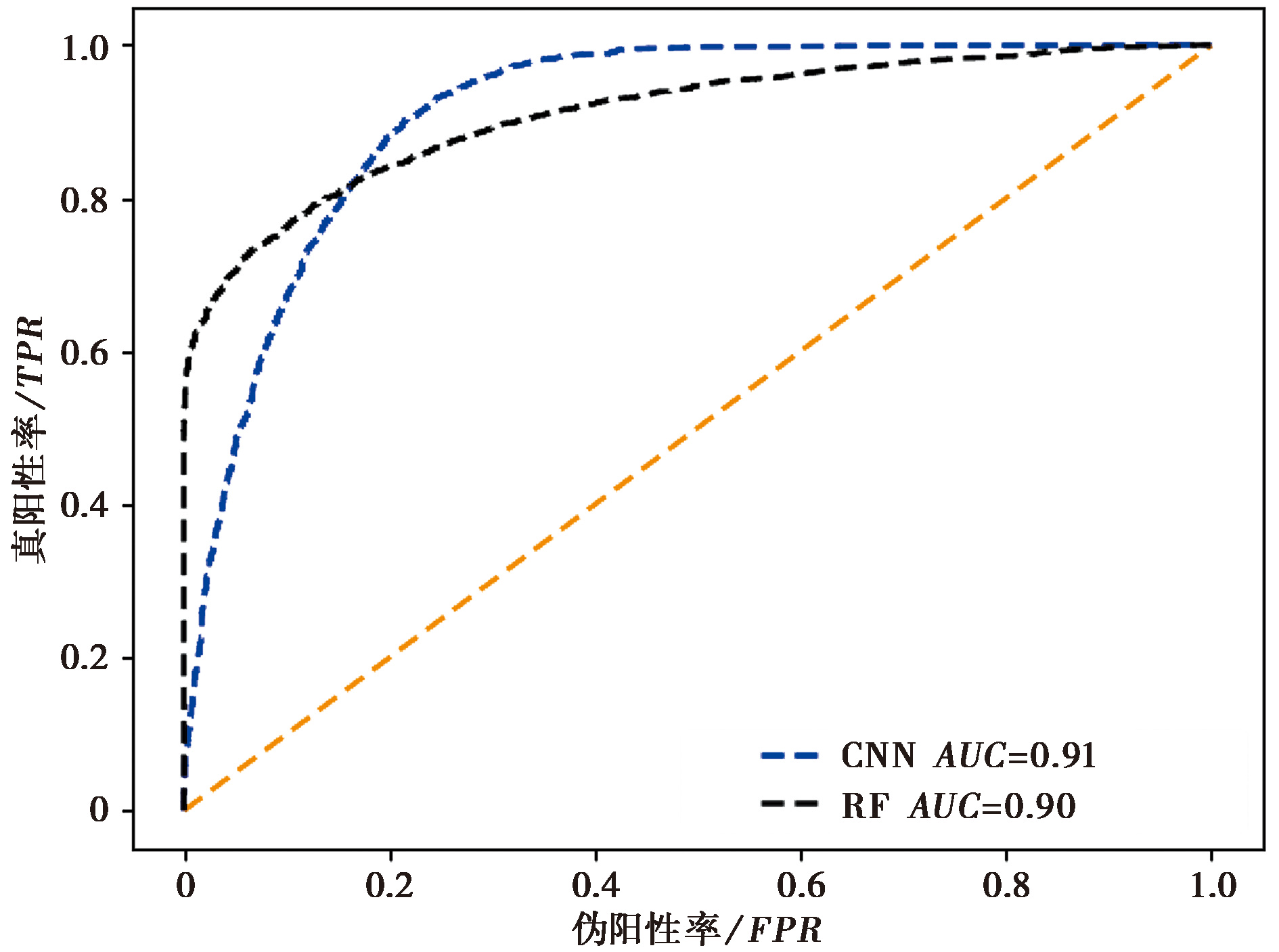
Fig. 12 The ROC curve and AUC value.
| 模型 | TP | TN | FN | FP | 准确率 | 精确度 | 召回率 | F1-score |
|---|---|---|---|---|---|---|---|---|
| AlexNetCBAM | 2883 | 2441 | 726 | 284 | 0.841 | 0.910 | 0.799 | 0.851 |
| RF | 2941 | 2307 | 860 | 226 | 0.829 | 0.929 | 0.774 | 0.844 |
Table 2 Accuracy value, precision value, recall value and F1-score for two different models
| 模型 | TP | TN | FN | FP | 准确率 | 精确度 | 召回率 | F1-score |
|---|---|---|---|---|---|---|---|---|
| AlexNetCBAM | 2883 | 2441 | 726 | 284 | 0.841 | 0.910 | 0.799 | 0.851 |
| RF | 2941 | 2307 | 860 | 226 | 0.829 | 0.929 | 0.774 | 0.844 |
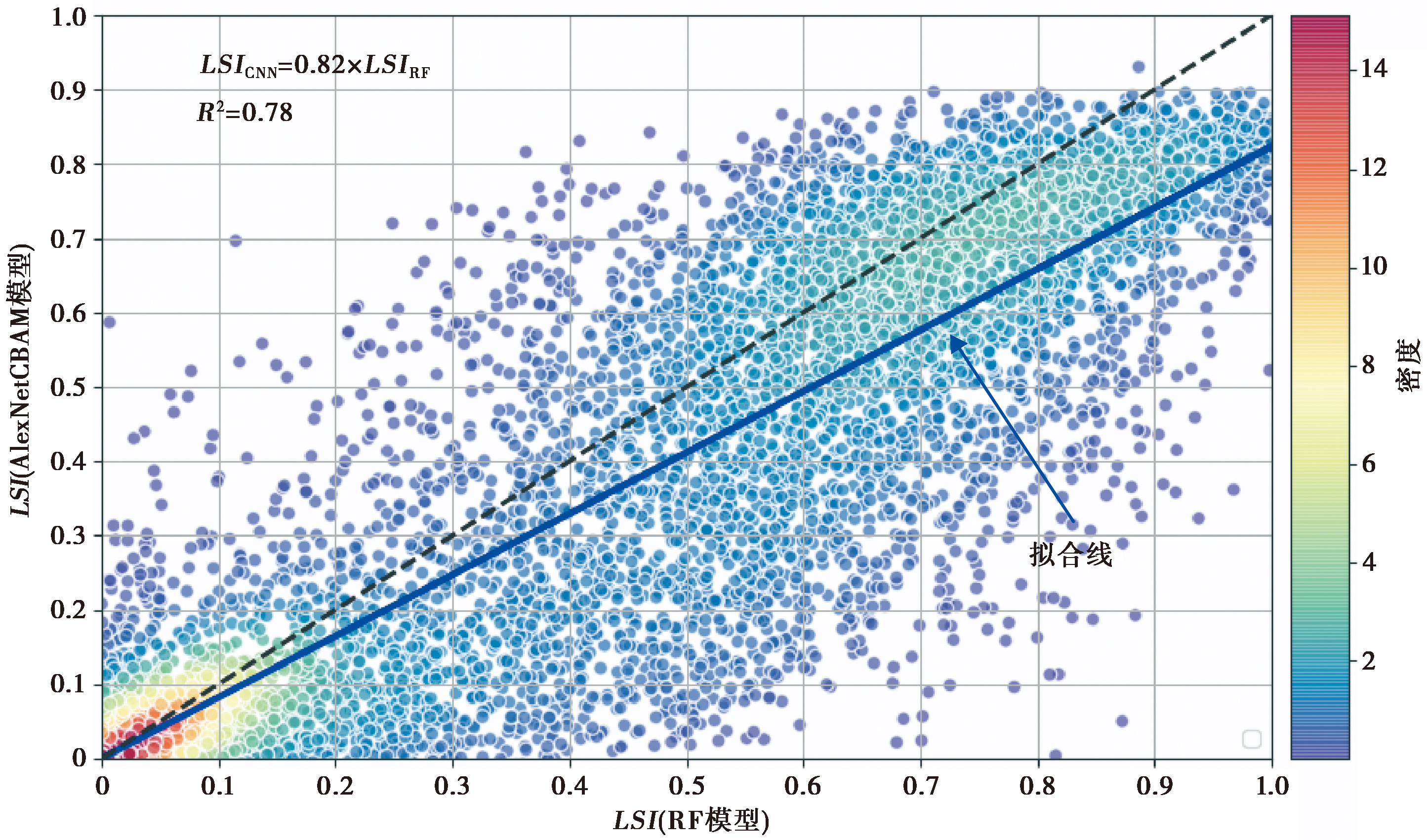
Fig. 13 The relationship of LSI between AlexNetCBAM and RF-based landslide susceptibility assessment results.

Fig. 14 Comparison of local landslide distribution in the occurrence probabilistic map.
| [1] |
杜鹏, 陈宁生, 伍康林, 等. 2024. 基于随机森林模型的藏东南地区滑坡易发性评价及主控因素分析[J]. 成都理工大学学报(自然科学版), 51(2): 328—344.
|
|
|
|
| [2] |
侯沙沙. 2021. 注意力引导卷积神经网络的高分辨率遥感影像分类方法研究[D]. 西安: 西安科技大学.
|
|
|
|
| [3] |
孔嘉旭, 庄建琦, 彭建兵, 等. 2023. 基于信息量和卷积神经网络的黄土高原滑坡易发性评价[J]. 地球科学, 48(5): 1711—1729.
|
|
|
|
| [4] |
王世宝, 庄建琦, 郑佳, 等. 2022. 基于深度学习的CZ铁路康定—理塘段滑坡易发性评价[J]. 工程地质学报, 30(3): 908—919.
|
|
|
|
| [5] |
吴玮莹, 许冲. 2018. 2014年鲁甸 MW6.2 地震触发滑坡新编目[J]. 地震地质, 40(5): 1140—1148.
|
|
|
|
| [6] |
许冲. 2015. 利用同震滑坡分析2014年鲁甸地震震源性质与破裂过程[J]. 工程地质学报, 23(4): 755—759.
|
|
|
|
| [7] |
许冲, 徐锡伟, 沈玲玲, 等. 2014. 2014年鲁甸 MS6.5 地震触发滑坡编录及其对一些地震参数的指示[J]. 地震地质, 36(4): 1186—1203.
|
|
|
|
| [8] |
杨硕, 李德营, 严亮轩, 等. 2021. 基于随机森林模型的乌江高陡岸坡滑坡地质灾害易发性评价[J]. 安全与环境工程, 28(4): 131—138.
|
|
|
|
| [9] |
DOI |
| [10] |
DOI |
| [11] |
|
| [12] |
|
| [13] |
|
| [14] |
|
| [15] |
|
| [16] |
DOI URL |
| [17] |
DOI URL |
| [18] |
DOI URL |
| [19] |
DOI URL |
| [20] |
DOI URL |
| [21] |
|
| [22] |
DOI URL |
| [23] |
|
| [24] |
|
| [25] |
DOI URL |
| [26] |
|
| [27] |
DOI URL |
| [28] |
DOI URL |
| [29] |
DOI URL |
| [30] |
DOI URL |
| [31] |
|
| [32] |
DOI URL |
| [33] |
|
| [34] |
|
| [35] |
|
| [36] |
DOI |
| [37] |
|
| [38] |
|
| [39] |
|
| [40] |
|
| [41] |
|
| [42] |
DOI |
| [43] |
DOI URL |
| [44] |
|
| [45] |
DOI URL |
| [46] |
|
| [47] |
DOI URL |
| [48] |
|
| [49] |
|
| [50] |
DOI URL |
| [51] |
DOI URL |
| [52] |
DOI |
| [53] |
|
| [54] |
DOI |
| [55] |
DOI URL |
| [56] |
DOI |
| [57] |
|
| [58] |
DOI URL |
| [1] | WU Wei-ying, XU Chong. A NEW INVENTORY OF LANDSLIDES TRIGGERED BY THE 2014 LUDIAN MW6.2 EARTHQUAKE [J]. SEISMOLOGY AND GEOLOGY, 2018, 40(5): 1140-1148. |
| [2] | XU Chong, TIAN Ying-ying, SHEN Ling-ling, MA Si-yuan, XU Xi-wei, ZHOU Ben-gang, HUANG Xue-qiang, MA Jun-xue, CHEN Xi. DATABASE OF LANDSLIDES TRIGGERED BY 2015 GORKHA(NEPAL) MW7.8 EARTHQUAKE [J]. SEISMOLOGY AND GEOLOGY, 2018, 40(5): 1115-1128. |
| [3] | TIAN Ying-ying, XU Chong, XU Xi-wei, WU Sai-er, CHEN Jian. SPATIAL DISTRIBUTION ANALYSIS OF COSEISMIC AND PRE-EARTHQUAKE LANDSLIDES TRIGGERED BY THE 2014 LUDIAN MS6.5 EARTHQUAKE [J]. SEISMOLOGY AND GEOLOGY, 2015, 37(1): 291-306. |
| Viewed | ||||||
|
Full text |
|
|||||
|
Abstract |
|
|||||
Copyright © SEISMOLOGY AND GEOLOGY, All Rights Reserved.
Tel: 010-62009049/9063 E-mail: dzdz@ies.ac.cn
Powered by Beijing Magtech Co., Ltd.