
SEISMOLOGY AND GEOLOGY ›› 2026, Vol. 48 ›› Issue (3): 853-869.DOI: 10.3969/j.issn.0253-4967.20240172
• Research paper • Previous Articles Next Articles
ANALYSIS OF TECTONIC DEFORMATION CHARACTERISTICS OF THE DAQINGSHAN FRONTAL FAULT ZONE USING HIGH-RESOLUTION REMOTE SENSING IMAGERY
QU Hao-xin1,2)( ), GAO Li-xin2), BAO Ren-kai2), LI Dong2), ZHANG Hao3)
- 1)
State Key Laboratory of Earthquake Dynamics and Forecasting ,Institute of Geology, China Earthquake Administration
2)Inner Mongolia Earthquake Agency
3)Jiangsu Earthquake Agency
-
Received:2025-02-28Revised:2025-04-26Online:2026-06-20Published:2026-07-09
基于高分遥感影像的大青山山前断裂带构造变形特征
曲浩鑫1,2)(), 高立新2), 包任锴2), 李东2), 张浩3)
- 1)
地震动力学与强震预测全国重点实验室(中国地震局地质研究所)
2)内蒙古自治区地震局
3)江苏省地震局
-
作者简介:曲浩鑫, 女, 1995年生, 2019年于中国地质大学(北京)获矿产普查与勘探专业硕士学位, 现为中国地震局地质研究所固体地球物理专业在读博士研究生, 工程师, 主要从事活动构造、地震地质研究, E-mail: 511839990@qq.com。
-
基金资助:内蒙古自治区地震局局长基金(2024GG01)

Cite this article
QU Hao-xin, GAO Li-xin, BAO Ren-kai, LI Dong, ZHANG Hao. ANALYSIS OF TECTONIC DEFORMATION CHARACTERISTICS OF THE DAQINGSHAN FRONTAL FAULT ZONE USING HIGH-RESOLUTION REMOTE SENSING IMAGERY[J]. SEISMOLOGY AND GEOLOGY, 2026, 48(3): 853-869.
曲浩鑫, 高立新, 包任锴, 李东, 张浩. 基于高分遥感影像的大青山山前断裂带构造变形特征[J]. 地震地质, 2026, 48(3): 853-869.
share this article
Add to citation manager EndNote|Ris|BibTeX
URL: https://www.dzdz.ac.cn/EN/10.3969/j.issn.0253-4967.20240172
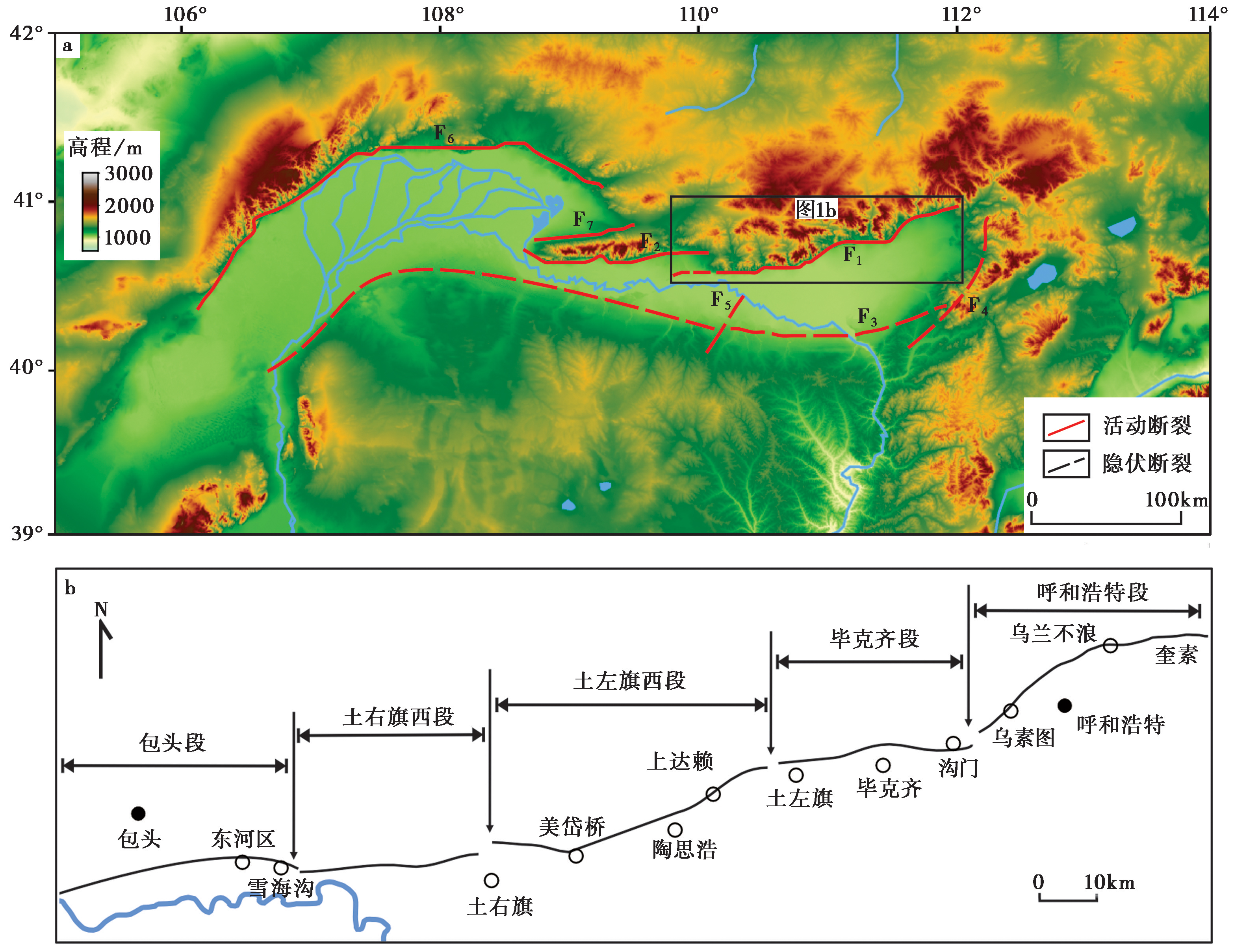
Fig. 1 Location and segmentation diagram of the Daqingshan frontal fault zone.
| 时代 | 断裂垂直位移量 | 断裂活动速率 | 台地高程 | 台地形成时代 |
|---|---|---|---|---|
| 晚更新世 | 总垂直位移量为501m | 4.6mm/a | 1100~1120m | 晚更新世晚期 |
| 1070~1080m | 晚更新世末 | |||
| 早全新世 | 最大断距达10m以上 | 2.8mm/a | 1045~1065m | 全新世早期 |
| 晚全新世 | 活动幅度>8m |
Table1 Kinematic parameters and platform elevation of the Daqingshan frontal fault zone
| 时代 | 断裂垂直位移量 | 断裂活动速率 | 台地高程 | 台地形成时代 |
|---|---|---|---|---|
| 晚更新世 | 总垂直位移量为501m | 4.6mm/a | 1100~1120m | 晚更新世晚期 |
| 1070~1080m | 晚更新世末 | |||
| 早全新世 | 最大断距达10m以上 | 2.8mm/a | 1045~1065m | 全新世早期 |
| 晚全新世 | 活动幅度>8m |
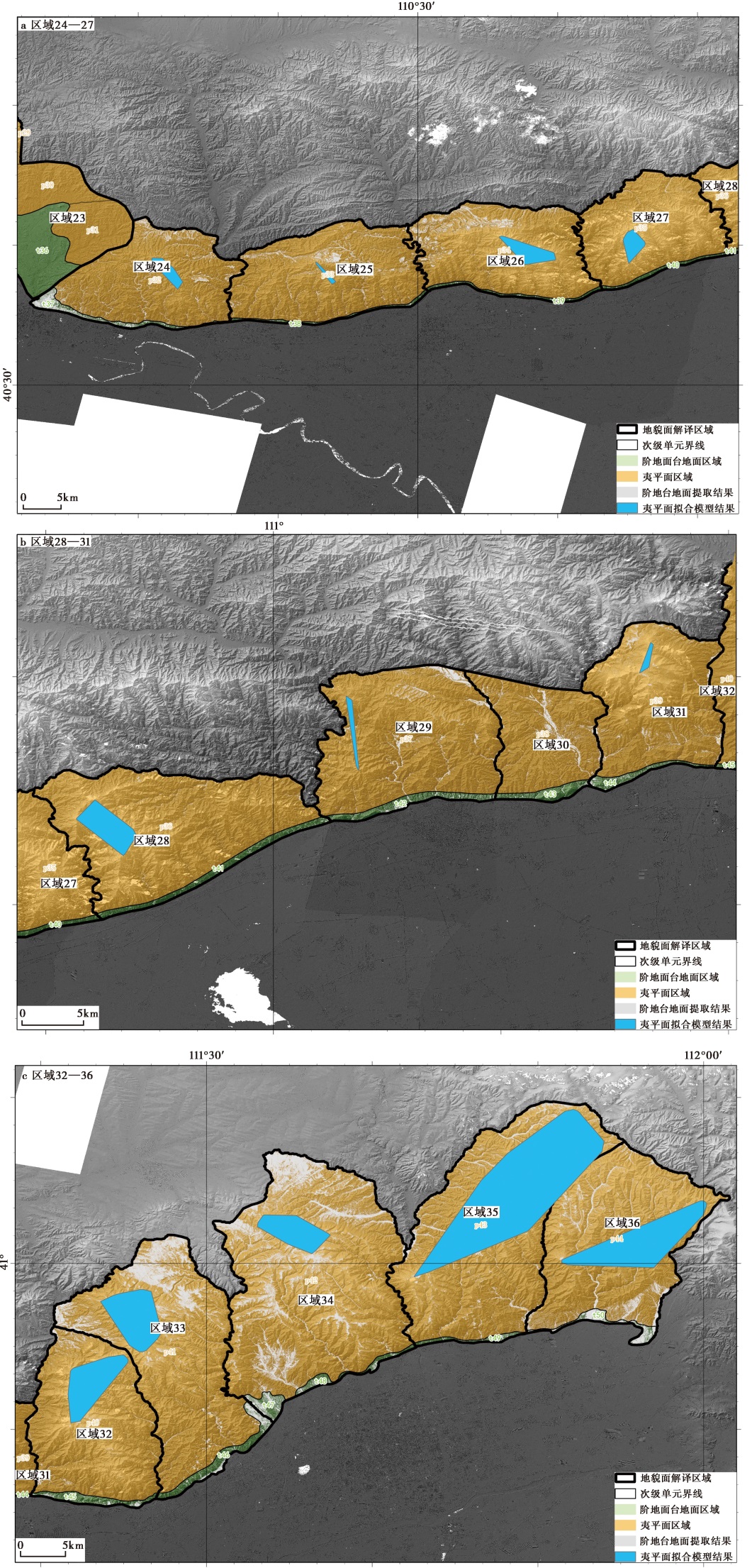
Fig. 2 Interpretation of the results of the geomorphic surfaces in the Daqingshan frontal fault zone.

Fig. 3 Interpretation of the results of the terrace surface area of secondary terraces.
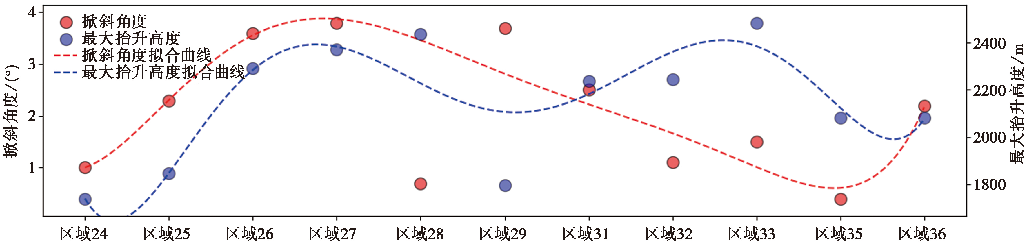
Fig. 4 Distribution of tectonic deformation results of the main planation surface in the Daqingshan frontal fault zone.
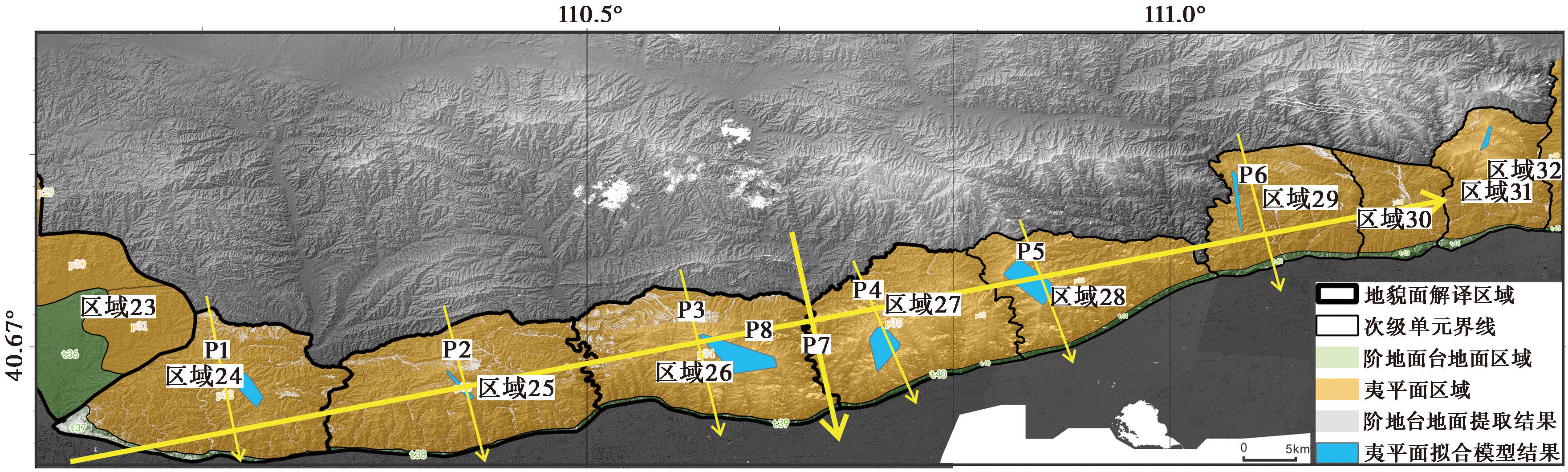
Fig. 5 Distribution map of tectonic deformation profiles in the western and central sections of Daqingshan Mountain(zone 24—30).
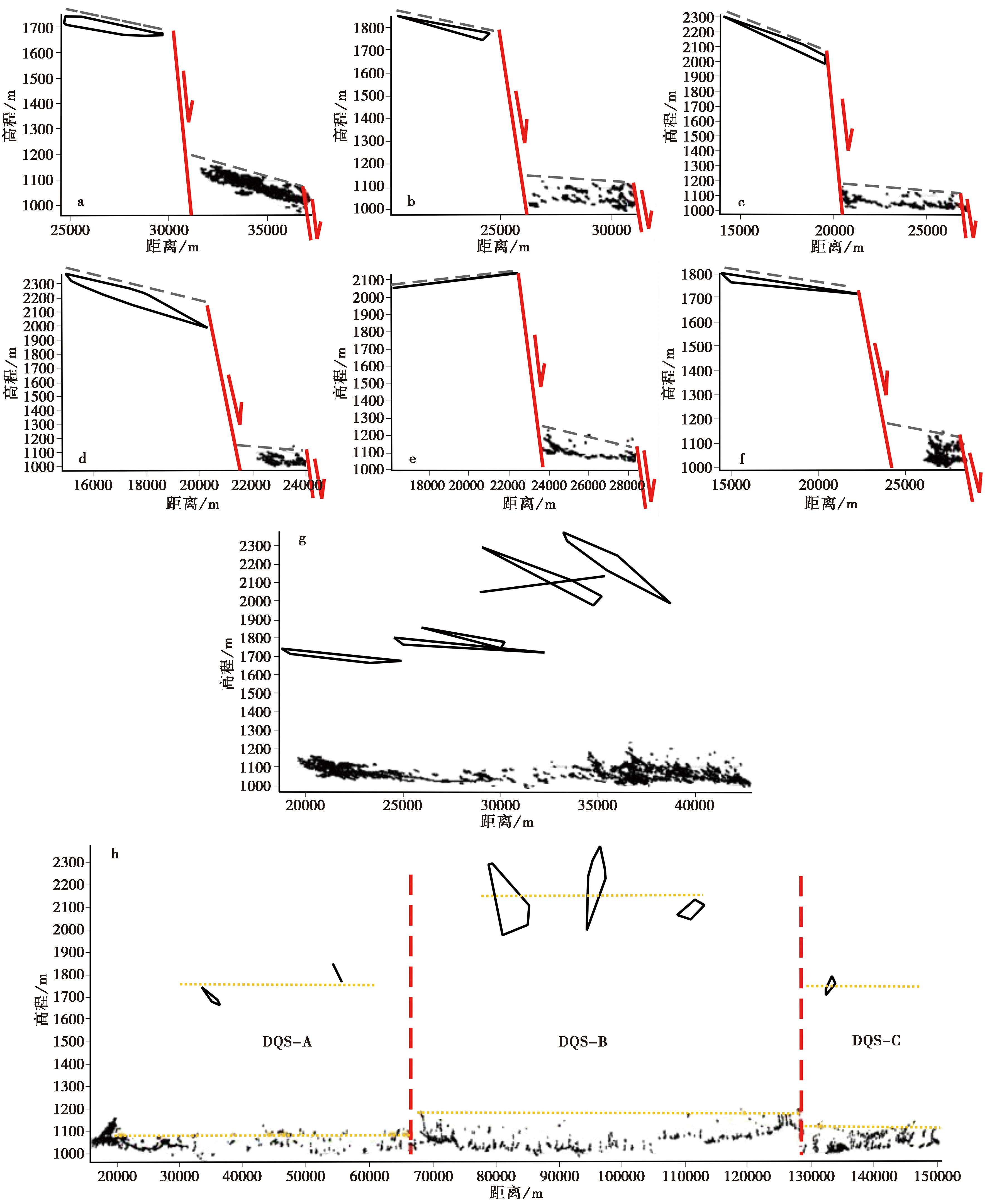
Fig. 6 Results of tectonic deformation profiles in the western and central sections of Daqingshan Mountain(zone 24—30).

Fig. 7 Distribution map of tectonic deformation profiles in the eastern sections of Daqingshan Mountain(zone 31—36).
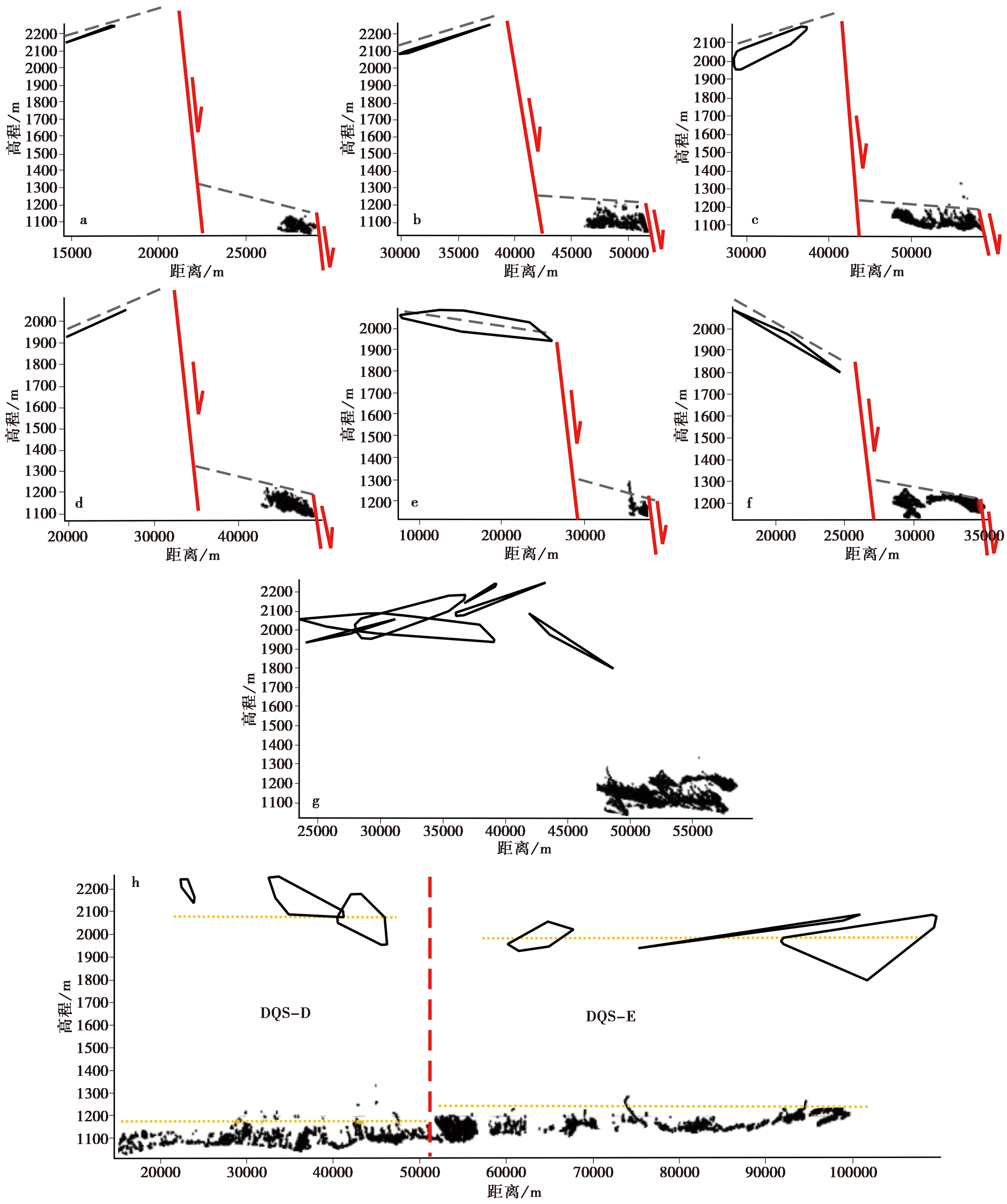
Fig. 8 Results of tectonic deformation profiles in the eastern sections of Daqingshan Mountain(zone 31—36).
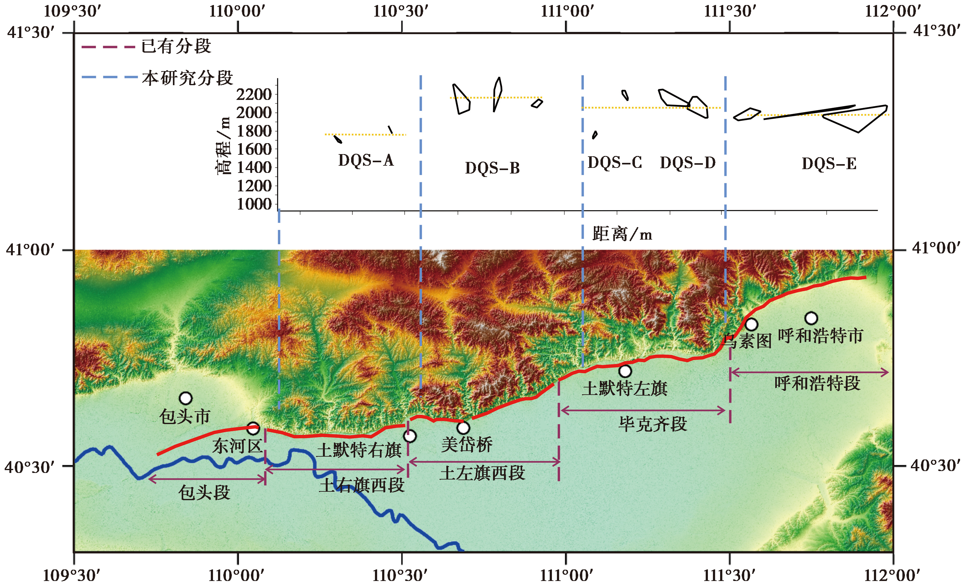
Fig. 9 Comparison of segmentation modes of the fault zone in front of Daqingshan Mountain.

Fig. 10 Field-measured relative height and absolute altitude of the tertiary terrace.
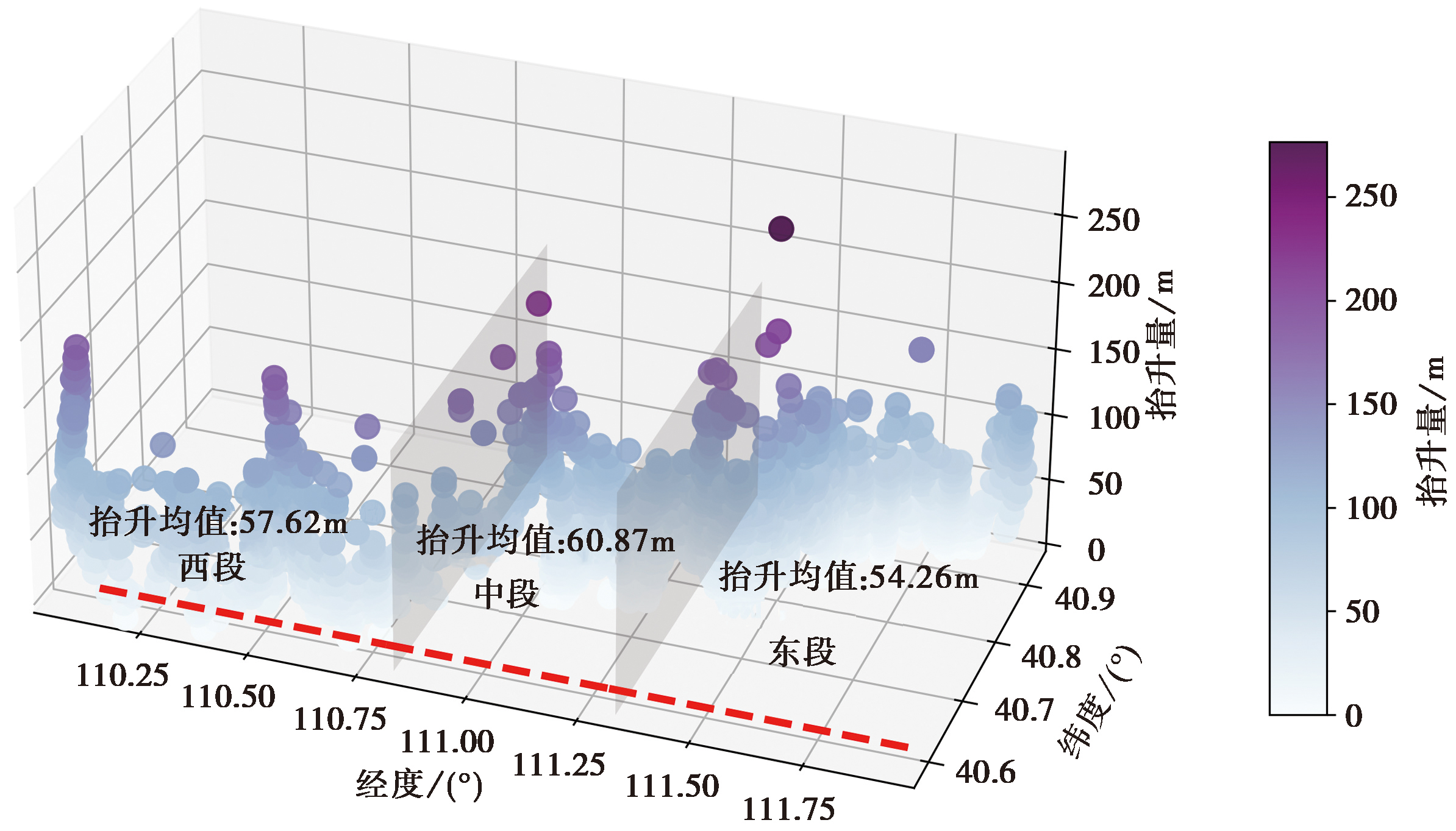
Fig. 11 Estimation of the vertical uplift amount of geomorphic surfaces along the fault zone in front of Daqingshan Mountain.
| [1] |
陈立春, 冉勇康, 常增沛. 2003. 色尔腾山山前断裂得令山以东段晚第四纪活动特征与古地震事件[J]. 地震地质, 25(4): 555-565.
|
|
|
|
| [2] |
高泽民, 刘兴旺, 邵延秀, 等. 2019. 河套盆地北缘大青山地区构造地貌特征[J]. 地震地质, 41(6): 1317-1332. doi: 10.3969/j.issn.0253-4967.2019.06.001.
|
|
DOI |
|
| [3] |
国家地震局“鄂尔多斯周缘活动断裂系”课题组. 1988. 鄂尔多斯周缘活动断裂系[M]. 北京: 地震出版社: 1-285.
|
|
The Research Group on “Active Fault System around Ordos Massif”, State Seismological Bureau. 1988. Active Fault System around Ordos Massif[M]. Seismological Press, Beijing: 1-285 (in Chinese).
|
|
| [4] |
何仲太. 2006. 大青山山前活动断裂的分段地震危险性概率评估[G]//中国地震局地壳应力研究所. 地壳构造与地壳应力文集. 北京: 地震出版社: 35-41.
|
|
|
|
| [5] |
何仲太, 马保起, 卢海峰. 2007. 大青山山前活动断裂带分段与潜在震源区划分[J]. 地震地质, 29(4): 765-775.
|
|
|
|
| [6] |
江娃利, 肖振敏, 王焕贞, 等. 2001. 内蒙大青山山前活动断裂带的地震破裂分段特征[J]. 地震地质, 23(1): 24-34.
|
|
|
|
| [7] |
李克, 吴卫民, 杨发, 等. 1994. 大青山山前活动断裂分段性研究[G]//中国地震学会地震地质专业委员会. 中国活动断层研究. 北京: 地震出版社: 102-113.
|
|
|
|
| [8] |
李雪梅. 2020. 内蒙古大青山地区基岩河流地貌研究: 对河套盆地晚新生代构造和黄河演化的启示[D]. 北京: 中国地震局地质研究所.
|
|
|
|
| [9] |
马保起, 李克, 吴卫民. 2000. 大青山山前断裂活动的分段性研究[G]//中国地震局地壳应力研究所. 地壳构造与地壳应力文集. 北京: 地震出版社: 53-60.
|
|
|
|
| [10] |
聂宗笙, 李克, 陈健. 1986. 大青山山前断裂带中、晚全新世活动的发现[J]. 地质科学, 21(3): 217-220.
|
|
|
|
| [11] |
聂宗笙, 任云, 刘志明, 等. 2011. 内蒙古包头市区大青山山前断裂地震活动断层初步研究[J]. 现代地质, 25(5): 938-957.
|
|
|
|
| [12] |
冉勇康, 张培震, 陈立春. 2003. 河套断陷带大青山山前断裂晚第四纪古地震完整性研究[J]. 地学前缘, 10(S1): 207-216.
|
|
|
|
| [13] |
冉勇康, 张培震, 胡博, 等. 2002. 大青山山前断裂呼和浩特段晚第四纪古地震活动历史[J]. 中国地震, 18(1): 15-27.
|
|
|
|
| [14] |
吴卫民, 李克, 马保起, 等. 1995. 大青山山前活动断裂带大型组合探槽的全新世古地震研究[G]//国家地震局地质研究所. 活动断裂研究(4). 北京: 地震出版社: 123-132.
|
|
|
|
| [15] |
张会平, 刘少峰, 孙亚平, 等. 2006. 基于SRTM-DEM区域地形起伏的获取及应用[J]. 国土资源遥感, 18(1): 31-35.
|
|
|
|
| [16] |
DOI URL |
| [17] |
|
| [1] | LIU Rui-chun, ZHANG Jin, GUO Wen-feng, CHEN Hui, ZHENG Ya-di, CHENG Cheng. STUDY ON THE RECENT DEFORMATION CHARACTERISTIC AND STRUCTURAL DEFORMATION MODEL OF THE SOUTH-EASTERN MARGIN OF ORDOS BLOCK [J]. SEISMOLOGY AND GEOLOGY, 2021, 43(3): 540-558. |
| [2] | HA Guang-hao, REN Zhi-kun, LIU Jin-rui, LI Zhi-min, LI Zheng-fang, MIN Wei, ZHOU Ben-gang. NEW DISCOVERY OF XIARIHA FAULT ZONE AROUND DULAN AREA, QINGHAI PROVINCE AND ITS TECTONIC IMPLICATIONS [J]. SEISMOLOGY AND GEOLOGY, 2021, 43(3): 614-629. |
| [3] | DAI Cheng-long, ZHANG Ling, LIANG Shi-ming, ZHANG Ke-liang, XIONG Xiao-hui, GAN Wei-jun. PRESENT-DAY STRIKE-SLIP RATE AND ITS SEGMENTAL VARIATION OF THE TALAS-FERGHANA FAULT IN CENTRAL ASIA: INSIGHT FROM GPS GEODETIC OBSERVATIONS [J]. SEISMOLOGY AND GEOLOGY, 2021, 43(2): 263-279. |
| [4] | LIU Rui, LI An, ZHANG Shi-min, CHEN Zhi-dan, GUO Chang-hui. THE LATE QUATERNARY TECTONIC DEFORMATION REVEALED BY THE TERRACES ON THE BAIYANG RIVER IN THE NORTHERN QILIAN MOUNTAINS [J]. SEISMOLOGY AND GEOLOGY, 2017, 39(6): 1237-1255. |
| [5] | LEI Qi-yun, ZHANG Pei-zhen, ZHENG Wen-jun, DU Peng, WANG Wei-tao, YU Jing-xing, XIE Xiao-feng. GEOLOGICAL AND GEOMORPHIC EVIDENCE FOR DEXTRAL STRIKE SLIP OF THE HELAN SHAN WEST-PIEDMONT FAULT AND ITS TECTONIC IMPLICATIONS [J]. SEISMOLOGY AND GEOLOGY, 2017, 39(6): 1297-1315. |
| [6] | WANG Zhi-cai, WANG Dong-lei, XU Hong-tai, GE Fu-gang, YANG Chuan-cheng, LI Jian-hu. GEOMETRIC FEATURES AND LATEST ACTIVITIES OF THE NORTH SEGMENT OF THE ANQIU-JUXIAN FAULT [J]. SEISMOLOGY AND GEOLOGY, 2015, 37(1): 176-191. |
| [7] | HE Fu-bing, BAI Ling-yan, WANG Ji-ming, LIU Yu, CAI Xiang-min, SUN Yong-hua, ZHANG Lei, FANG Tong-ming, GUO Gao-xuan. DEEP STRUCTURE AND QUATERNARY ACTIVITIES OF THE XIADIAN FAULT ZONE [J]. SEISMOLOGY AND GEOLOGY, 2013, 35(3): 490-505. |
| [8] | WANG Wei-tao, ZHANG Pei-zhen, LEI Qi-yun. DEFORMATIONAL CHARACTERISTICS OF THE NIUSHOUSHAN-LUOSHAN FAULT ZONE AND ITS TECTONIC IMPLICATIONS [J]. SEISMOLOGY AND GEOLOGY, 2013, 35(2): 195-207. |
| [9] | DONG Shao-peng, HAN Zhu-jun, YIN Jin-hui, LI Feng, AN Yan-fen. A PRELIMINARY RESEARCH ON THE LATEST TECTONIC DEFORMATION STYLE AND THE ACTIVITY AGE OF THE DAYI FAULT IN THE PIEDMONT OF THE LONGMEN MOUNTAINS [J]. SEISMOLOGY AND GEOLOGY, 2008, 30(4): 996-1003. |
| [10] | ZHENG Wen-jun, WANG Wei-tao, LI Chuan-you, WEI Zhan-yu, GAO Xiang. THE DEFORMATION OF THE XIONGPO ANTICLINE AND THE ACTIVITY OF PUJIANG-XINJIN FAULT [J]. SEISMOLOGY AND GEOLOGY, 2008, 30(4): 957-967. |
| [11] | ZHENG Wen-jun, LI Chuan-you, WANG Wei-tao, YIN Jin-hui, WEI Zhan-yu. TRENCH LOGS OF EARTHQUAKE SCARP OF THE MS8.0 WENCHUAN EARTHQUAKE IN THE SEGMENT NORTH OF BEICHUAN [J]. SEISMOLOGY AND GEOLOGY, 2008, 30(3): 697-709. |
| [12] | CHEN Chang-Yun, HE Hong-Lin. CRUST SHORTENING OF DALIANGSHAN TECTONIC ZONE IN CENOZOIC ERA AND ITS IMPLICATION [J]. SEISMOLOGY AND GEOLOGY, 2008, 30(2): 443-453. |
| [13] | YUAN Dao-yang, WANG Lan-min, HE Wen-gui, LIU Bai-chi, GE Wei-peng, LIU Xing-wang, LIANG Ming-jian, ZHENG Wen-jun. NEW PROGRESS OF SEISMIC ACTIVE FAULT PROSPECTING IN LANZHOU CITY [J]. SEISMOLOGY AND GEOLOGY, 2008, 30(1): 236-249. |
| [14] | XIANG Hong-fa, GUO Shun-min, ZHANG Wan-xia, HAN Zhu-jun, ZHANG Bing-liang, WAN Jing-lin, DONG Xing-quan, CHEN Li-chun. QUANTITATIVE STUDY ON THE LARGE SCALE DEXTRAL STRIKE-SLIP OFFSET IN THE SOUTHERN SEGMENT OF THE RED RIVER FAULT SINCE MIOCENE [J]. SEISMOLOGY AND GEOLOGY, 2007, 29(1): 34-50. |
| [15] | ZHANG Shi-min, NIE Gao-zhong, LIU Xu-dong, REN Jun-jie, SU Gang. KINEMATICAL AND STRUCTURAL PATTERNS OF YINGJING-MABIAN-YANJIN THRUST FAULT ZONE, SOUTHEAST OF TIBETAN PLATEAU, AND ITS SEGMENTATION FROM EARTHQUAKES [J]. SEISMOLOGY AND GEOLOGY, 2005, 27(2): 221-233. |
| Viewed | ||||||
|
Full text |
|
|||||
|
Abstract |
|
|||||
Copyright © SEISMOLOGY AND GEOLOGY, All Rights Reserved.
Tel: 010-62009049/9063 E-mail: dzdz@ies.ac.cn
Powered by Beijing Magtech Co., Ltd.