
SEISMOLOGY AND GEOLOGY ›› 2025, Vol. 47 ›› Issue (5): 1416-1437.DOI: 10.3969/j.issn.0253-4967.2025.05.20240016
• Research paper • Previous Articles Next Articles
RESEARCH OF THE INSAR COSEISMIC DEFORMATION AND INTERSEISMIC FAULTING MECHANISM OF THE 2023 JISHISHAN MW6.1 EARTHQUAKE
YANG Ying-hui1,2)( ), XIE Li-yuan1), XU Qiang1), WANG Yun-sheng1), ZHAO Jing-jing3), WANG Dao-ming4), CHEN Qiang3)
- 1)State Key Laboratory of Geohazard Prevention and Geoenvironment Protection, Chengdu University of Technology, Chengdu 610059, Sichuan, China
2)Research Center for Earthquake Disaster, Chengdu University of Technology, Chengdu 610059, Sichuan, China
3)Department of Remote Sensing and Geoinformation Engineering, Southwest Jiaotong University, Chengdu 610031, Sichuan, China
4)Huaneng Lancang River Hydropower Inc., Kunming 650214, China
-
Received:2024-02-02Revised:2024-04-25Online:2025-10-20Published:2025-11-11
2023年积石山MW6.1 地震InSAR同震形变与震间断裂运动机制
杨莹辉1,2)(), 谢丽媛1), 许强1), 王运生1), 赵晶晶3), 王道明4), 陈强3)
- 1)成都理工大学, 地质灾害防治与地质环境保护全国重点实验室, 成都 610059
2)成都理工大学, 地震研究中心, 成都 610059
3)西南交通大学, 测绘遥感信息系, 成都 610031
4)华能澜沧江水电股份有限公司, 昆明 650214
-
作者简介:杨莹辉, 男, 1987年生, 博士, 教授, 主要从事地震地质灾害InSAR形变监测与机制反演建模研究, E-mail: yinghuiyang_cdut@126.com。
-
基金资助:四川省哲学社会科学基金特别委托重大项目(SCJJ23WT06); 国家自然科学基金(42474041); 国家自然科学基金(42471485); 地质灾害防治与地质环境保护全国重点实验室研究课题(SKLGP2020K019); 地质灾害防治与地质环境保护全国重点实验室研究课题(SKLGP2021Z016)
Cite this article
YANG Ying-hui, XIE Li-yuan, XU Qiang, WANG Yun-sheng, ZHAO Jing-jing, WANG Dao-ming, CHEN Qiang. RESEARCH OF THE INSAR COSEISMIC DEFORMATION AND INTERSEISMIC FAULTING MECHANISM OF THE 2023 JISHISHAN MW6.1 EARTHQUAKE[J]. SEISMOLOGY AND GEOLOGY, 2025, 47(5): 1416-1437.
杨莹辉, 谢丽媛, 许强, 王运生, 赵晶晶, 王道明, 陈强. 2023年积石山MW6.1 地震InSAR同震形变与震间断裂运动机制[J]. 地震地质, 2025, 47(5): 1416-1437.
share this article
Add to citation manager EndNote|Ris|BibTeX
URL: https://www.dzdz.ac.cn/EN/10.3969/j.issn.0253-4967.2025.05.20240016

Fig. 1 Tectonic setting of the study region.
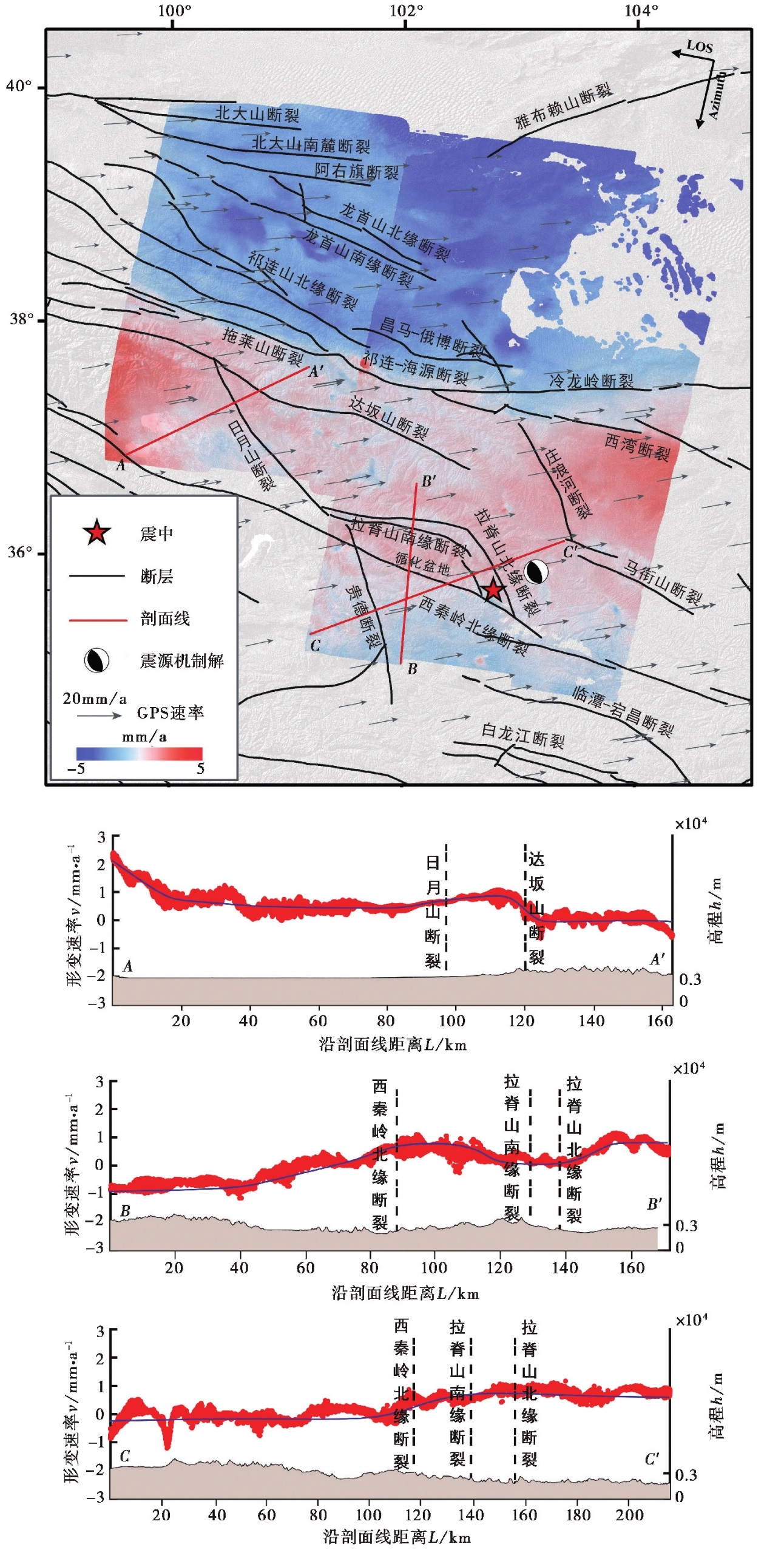
Fig. 2 Interseismic InSAR deformation velocity field in the seismic zone.
| 参数来源 | 走向/(°) | 倾角/(°) | 滑移角/(°) | 震级 |
|---|---|---|---|---|
| GCMT | 164 | 46 | 122 | MW6.1 |
| 303 | 52 | 62 | ||
| USGS | 156 | 28 | 93 | M5.9 |
| 333 | 62 | 88 | ||
| GFZ | 137 | 38 | 79 | MW6.0 |
| 331 | 52 | 98 | ||
| IGCEA | 156 | 28 | MW6.0 | |
| 刘振江等( | 143 | 38 | 104 | MW6.1 |
| 319 | 43 | 104 | ||
| 杨九元等( | 148.9 | 33.6 | 116.4 | MW6.1 |
| 311 | 53.8 | 79.6 | ||
| 王润妍等( | 159.08 | 40.57 | 112.46 | MW6.2 |
| 310.52 | 53.5 | 71.88 | ||
| 本文 | 131.0±4.2 | 23.3±0.9 | 94.0±3.3 | MW6.1 |
Table2 Fault parameters of the Jishishan earthquake reported by different institutions
| 参数来源 | 走向/(°) | 倾角/(°) | 滑移角/(°) | 震级 |
|---|---|---|---|---|
| GCMT | 164 | 46 | 122 | MW6.1 |
| 303 | 52 | 62 | ||
| USGS | 156 | 28 | 93 | M5.9 |
| 333 | 62 | 88 | ||
| GFZ | 137 | 38 | 79 | MW6.0 |
| 331 | 52 | 98 | ||
| IGCEA | 156 | 28 | MW6.0 | |
| 刘振江等( | 143 | 38 | 104 | MW6.1 |
| 319 | 43 | 104 | ||
| 杨九元等( | 148.9 | 33.6 | 116.4 | MW6.1 |
| 311 | 53.8 | 79.6 | ||
| 王润妍等( | 159.08 | 40.57 | 112.46 | MW6.2 |
| 310.52 | 53.5 | 71.88 | ||
| 本文 | 131.0±4.2 | 23.3±0.9 | 94.0±3.3 | MW6.1 |
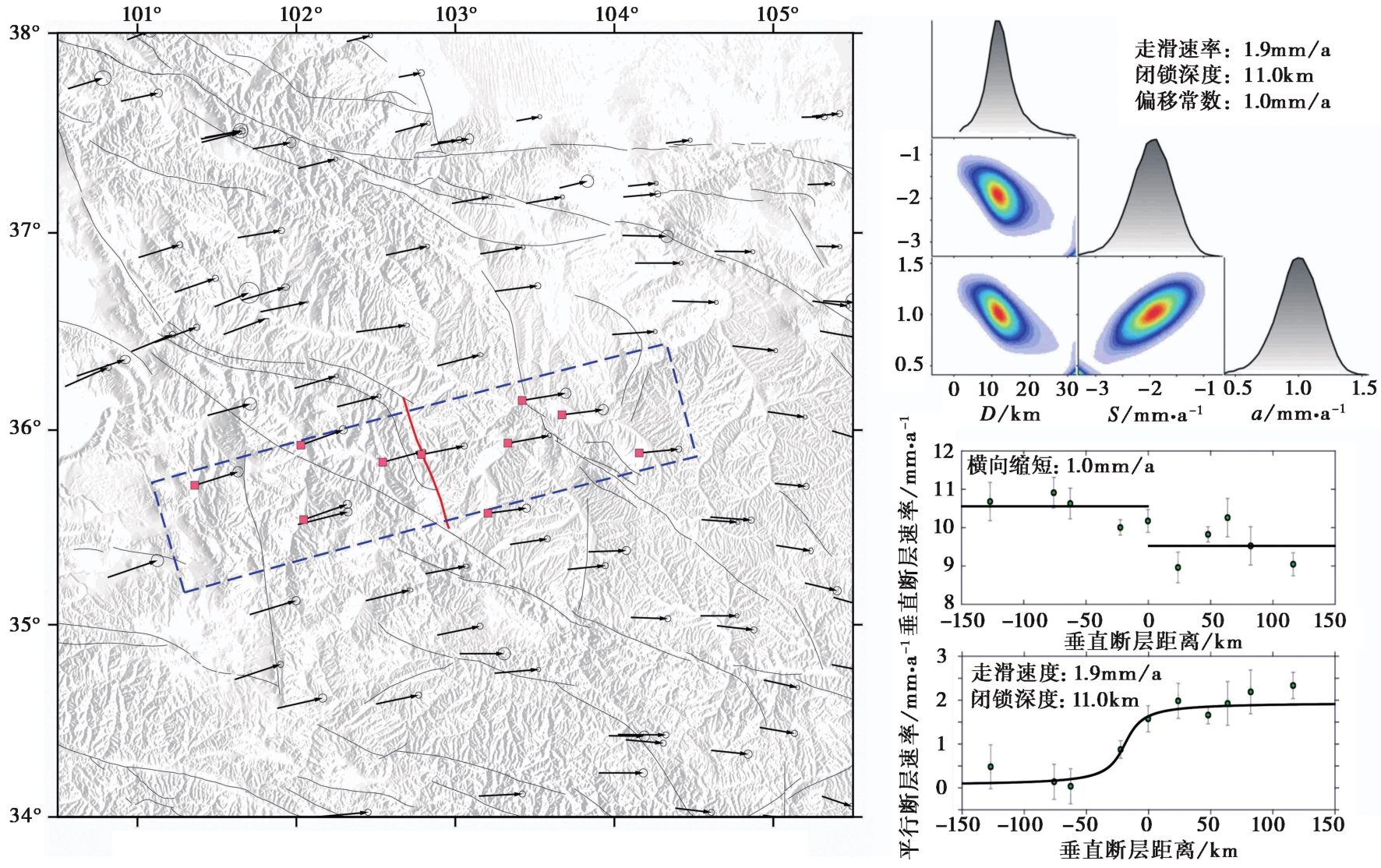
Fig. 3 Regional GPS displacement, estimated fault slip rate and locking depth of Lajishan Fault.
| 卫星 | 飞行方向 | 轨道 | 主影像日期 | 从影像日期 | 时间基线/d | 空间基线/m |
|---|---|---|---|---|---|---|
| Sentinel-1 | 升轨 | T128 | 2023-10-27 | 2023-12-26 | 60 | 65.3 |
| Sentinel-1 | 降轨 | T135 | 2023-12-14 | 2023-12-26 | 12 | 117.1 |
Table1 Parameters of Sentinel-1A SAR image
| 卫星 | 飞行方向 | 轨道 | 主影像日期 | 从影像日期 | 时间基线/d | 空间基线/m |
|---|---|---|---|---|---|---|
| Sentinel-1 | 升轨 | T128 | 2023-10-27 | 2023-12-26 | 60 | 65.3 |
| Sentinel-1 | 降轨 | T135 | 2023-12-14 | 2023-12-26 | 12 | 117.1 |
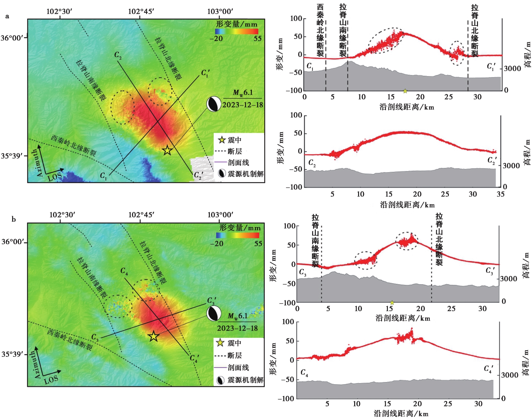
Fig. 4 Coseismic surface deformation field of the Jishishan earthquake.
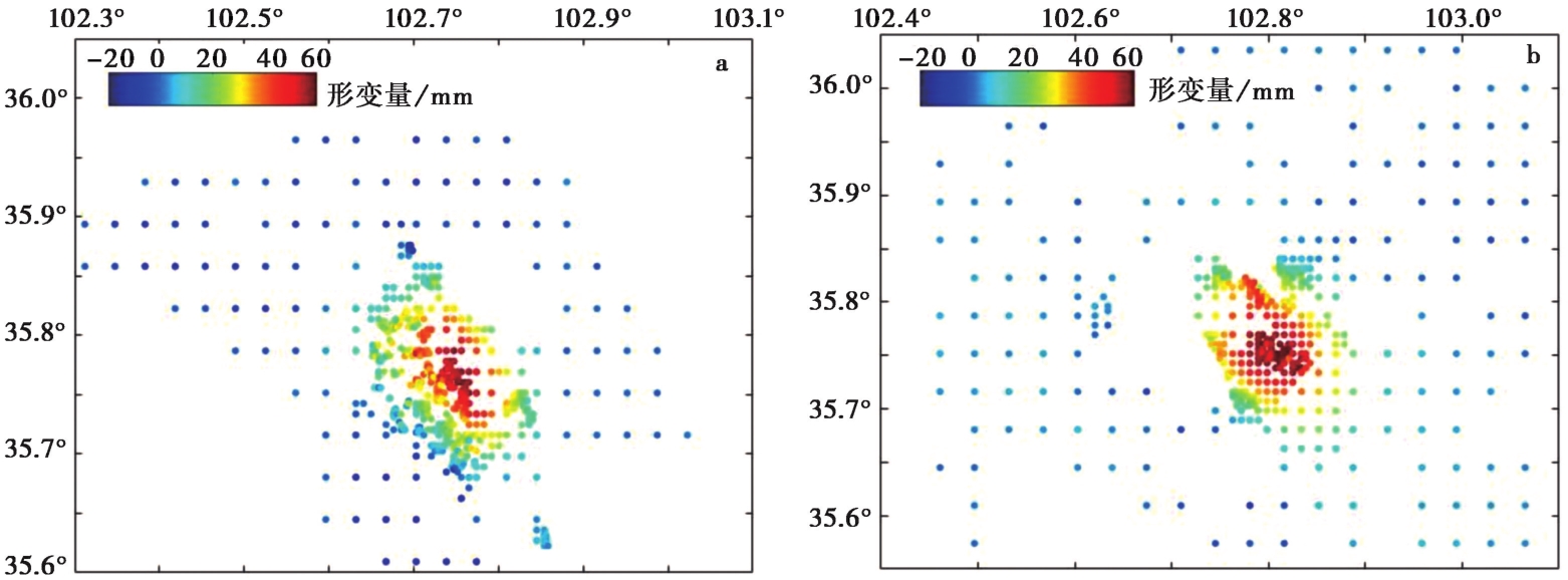
Fig. 5 Down-sampling InSAR deformation of the Jishishan earthquake.
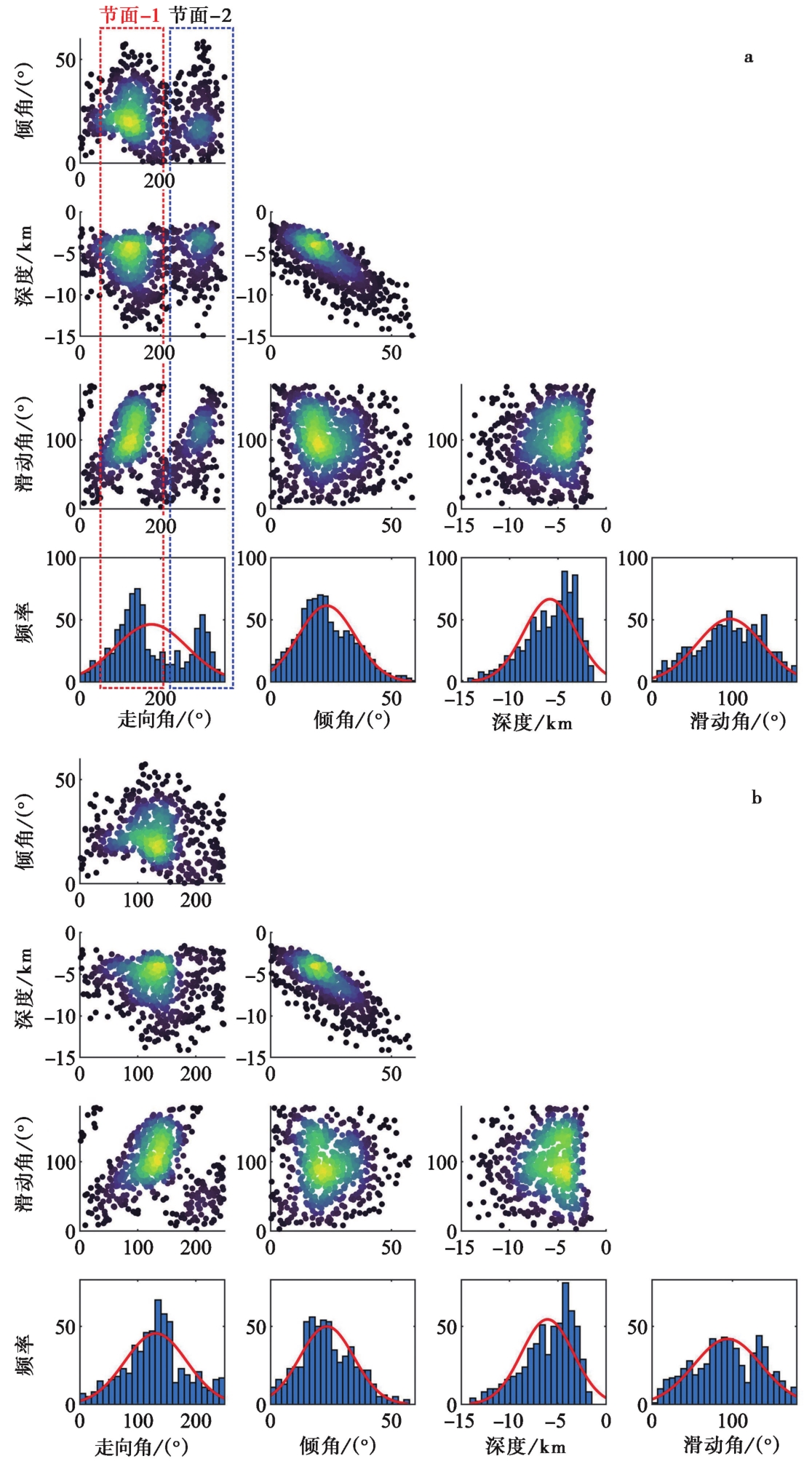
Fig. 6 Posterior probability distributions of the estimated fault parameters.
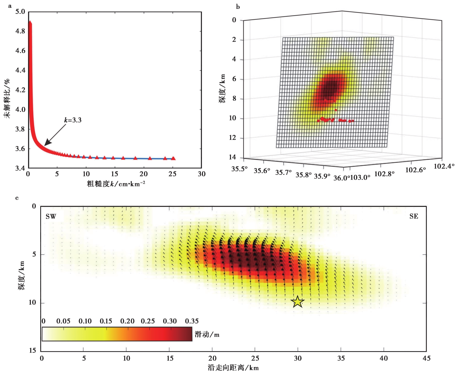
Fig. 7 Coseismic fault slip model of the Jishishan earthquake.
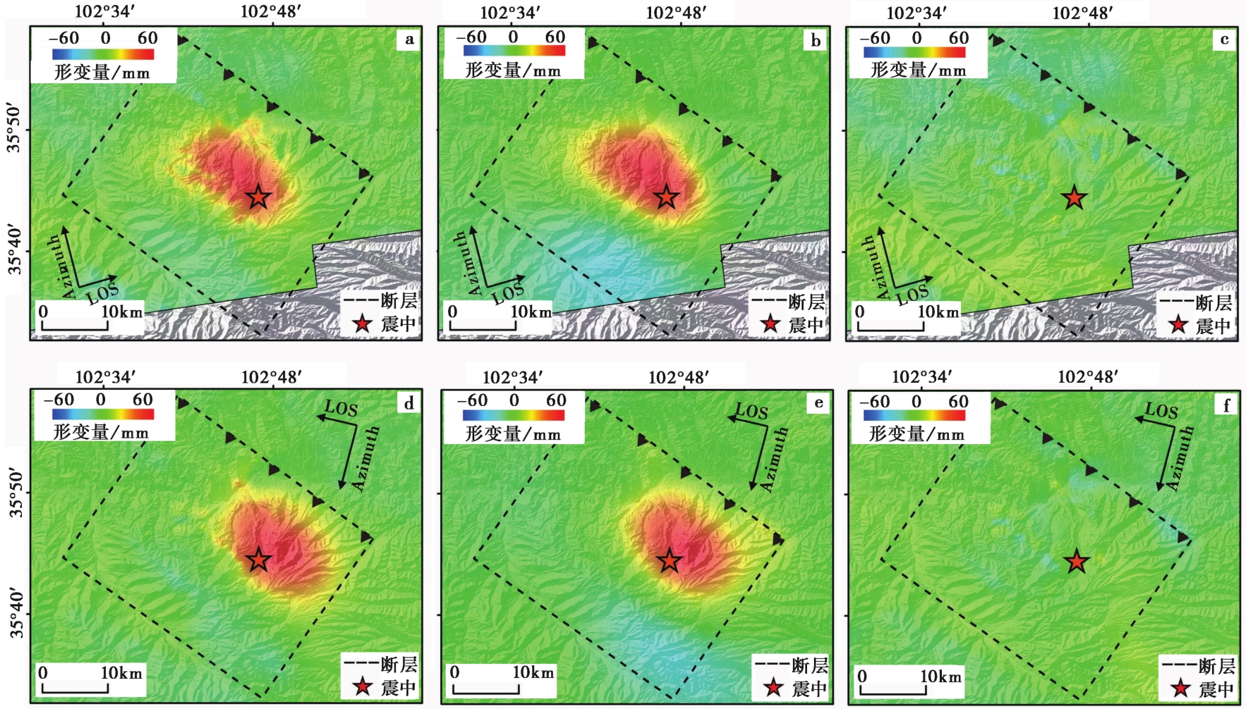
Fig. 8 Predicted coseismic InSAR deformation field and residual.
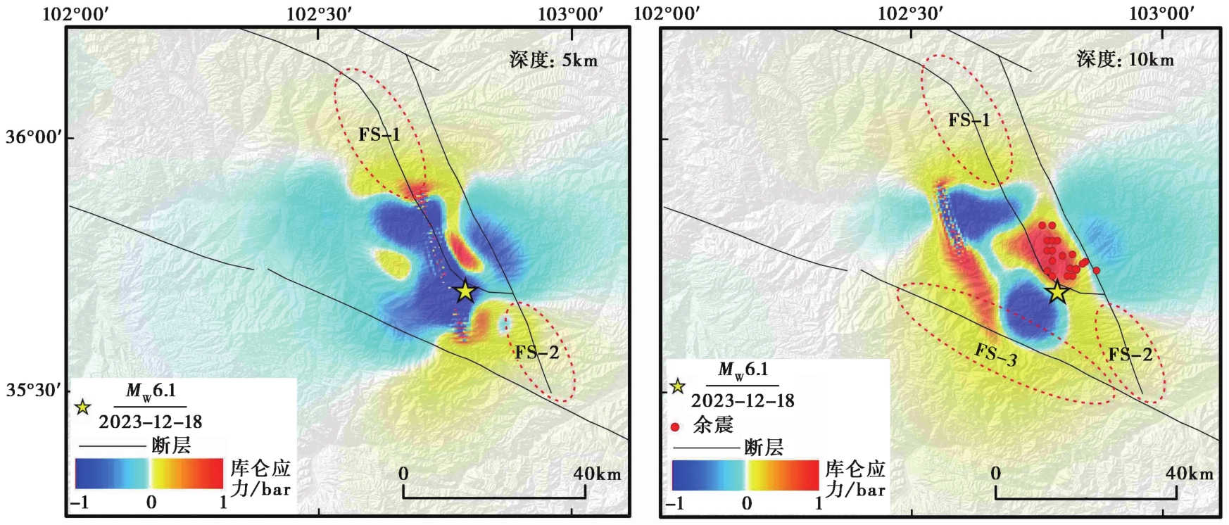
Fig. 9 The Coulomb failure stress change caused by the Jishishan earthquake.
| [1] |
陈博, 宋闯, 陈毅, 等. 2025. 2023年甘肃积石山 MS6.2 地震同震滑坡和建筑物损毁情况应急识别与影响因素研究[J]. 武汉大学学报(信息科学版), 50(2): 322-332.
|
|
|
|
| [2] |
邓起东. 2007. 中国活动构造图: 比例尺1︰400万[M]. 北京: 地震出版社.
|
|
|
|
| [3] |
方楠, 孙凯, 黄传超, 等. 2025. 联合InSAR和地震波数据反演甘肃积石山 MS6.2 地震震源时空破裂过程[J]. 武汉大学学报(信息科学版), 50(2): 333-343.
|
|
|
|
| [4] |
国家自然灾害防治研究院. 2023. 甘肃临夏州积石山县6.2级地震发震构造环境分析[EB/OL].(2023-12-20)[2023-12-24]. http://www.ninhm.ac.cn/content/details_104_4376.html.
|
|
National Institute of Natural Hazards. 2023. Analysis of the seismogenic tectonic environment of the MS6.2 earthquake in Jishishan County, Linxia Prefecture, Gansu Province[EB/OL].(2023-12-20)[2023-12-24]. http://www.ninhm.ac.cn/content/details_104_4376.html in Chinese).
|
|
| [5] |
李智敏, 李延京, 田勤俭, 等. 2014. 拉脊山断裂古地震与喇家遗址灾变事件关系研究[J]. 地震研究, 37(S1): 109-115.
|
|
|
|
| [6] |
李智敏, 田勤俭, 屠泓为. 2009. 拉脊山断裂带遥感特征研究[J]. 高原地震, 21(1): 26-31.
|
|
|
|
| [7] |
刘振江, 韩炳权, 能懿菡, 等. 2025. InSAR观测约束下的2023年甘肃积石山地震震源参数及其滑动分布[J]. 武汉大学学报(信息科学版), 50(2): 344-355.
|
|
|
|
| [8] |
陆诗铭, 吴中海, 李智超. 2024. 2023年12月18日甘肃省积石山6.2级地震的控震构造及特征[J]. 地震科学进展, 54(1): 86-93.
|
|
|
|
| [9] |
庞琪沛, 吴云龙, 徐景田, 等. 2025. 甘肃积石山 MS6.2 地震深部构造特征和动力学过程[J]. 武汉大学学报(信息科学版), 50(2): 356-367.
|
|
|
|
| [10] |
铁永波, 张宪政, 曹佳文, 等, 2024. 积石山 MS6.2 和泸定 MS6.8 地震地质灾害发育规律对比[J]. 成都理工大学学报(自然科学版), 51(1): 9-21.
|
|
|
|
| [11] |
王安简, 高原. 2024. 利用远场记录反演2023年甘肃积石山M6.2地震破裂过程[J]. 地震, 44(1): 195-203.
|
|
|
|
| [12] |
王立朝, 侯圣山, 董英, 等. 2024. 甘肃积石山 MS6.2 地震的同震地质灾害基本特征及风险防控建议[J]. 中国地质灾害与防治学报, 35(3): 108-118.
|
|
|
|
| [13] |
王勤彩, 罗钧, 陈翰林, 等. 2024. 2023年12月18日甘肃积石山6.2级地震震源机制解[J]. 地震, 44(1): 185-188.
|
|
|
|
| [14] |
王润妍, 万永革, 宋泽尧, 等. 2024. 2023年12月18日甘肃积石山6.2级地震震源机制及其对周围区域的应力影响[J]. 地震, 44(1): 175-184.
|
|
|
|
| [15] |
王运生, 赵波, 吉锋, 等. 2024. 2023年甘肃积石山 MS6.2 地震震害异常的启示[J]. 成都理工大学学报(自然科学版), 51(1): 1-8.
|
|
|
|
| [16] |
徐化超. 2018. 青藏高原东北缘地区主要活动断裂带的运动学研究[D]. 北京: 中国地震局地震预测研究所.
|
|
|
|
| [17] |
杨九元, 温扬茂, 许才军. 2025. InSAR观测揭示的2023年甘肃积石山 MS6.2 地震发震构造[J]. 武汉大学学报(信息科学版), 50(2): 313-321.
|
|
|
|
| [18] |
杨彦明, 苏淑娟. 2024. 2023年甘肃积石山 MS6.2 地震: 一次逆冲为主的浅源强震[J]. 地震, 44(1): 167-174.
|
|
|
|
| [19] |
杨中轩. 1993. 南祁连拉脊山北缘逆冲推覆构造带[J]. 石油实验地质, 15(2): 138-145.
|
|
|
|
| [20] |
袁道阳, 张培震, 雷中生, 等. 2005. 青海拉脊山断裂带新活动特征的初步研究[J]. 中国地震, 21(1): 93-102.
|
|
|
|
| [21] |
袁道阳, 张培震, 刘百篪, 等. 2004. 青藏高原东北缘晚第四纪活动构造的几何图像与构造转换[J]. 地质学报, 78(2): 270-278.
|
|
|
|
| [22] |
张波. 2012. 西秦岭北缘断裂西段与拉脊山断裂新活动特征研究[D]. 兰州: 中国地震局兰州地震研究所.
|
|
|
|
| [23] |
张驰, 李智敏, 任治坤, 等. 2022. 日月山断裂南段晚第四纪活动特征[J]. 地震地质, 44(1): 1-19. doi: 10.3969/j.issn.0253-4967.2022.01.001.
|
|
|
|
| [24] |
张培震, 郑德文, 尹功明, 等. 2006. 有关青藏高原东北缘晚新生代扩展与隆升的讨论[J]. 第四纪研究, 26(1): 5-13.
|
|
|
|
| [25] |
赵奉林, 刘文德. 1986. 对积石山地区地质构造特征的初步认识[G]. 青藏高原地质文集: 9.
|
|
|
|
| [26] |
中国地震局. 2023. 甘肃积石山6.2级地震为逆冲型破裂和主震-余震型地震[EB/OL].(2023-12-19)[2023-12-27]. https://www.cea.gov.cn/ceaxwzxmtbb/5747808/index.html.
|
|
China Earthquake Administration. 2023. The M6.2 magnitude earthquake in Jishishan, Gansu Province was a thrust rupture and mainshock-aftershock earthquake[EB/OL].(2023-12-19)[2023-12-27]. https://www.cea.gov.cn/ceaxwzxmtbb/5747808/index.html. in Chinese).
|
|
| [27] |
中国地震局地球物理研究所. 2023. 2023年12月18日甘肃临夏州积石山县6.2级地震科技支撑简报[EB/OL].(2023-12-19)[2023-12-27]. https://www.cea-igp.ac.cnkydt280418.html.
|
|
Institute of Geophysical, China Earthquake Administration. 2023. On December 18, 2023, a briefing on the scientific and technological support briefing on the the M6.2 magnitude earthquake in Jishishan County, Linxia Prefecture, Gansu Province[EB/OL].(2023-12-19)[2023-12-27]. https://www.cea-igp.ac.cnkydt280418.html. in Chinese).
|
|
| [28] |
中国地震局地震预测研究所. 2023. 2023年甘肃积石山6.2级地震滑动分布[EB/OL].(2023-12-21)[2023-12-27]. https://www.ief.ac.cn/kydts/info/2023/90215.html.
|
|
Institute of Earthquake Forecasting of the China Earthquake Administration. 2023. Sliding distribution of the M6.2 magnitude earthquakes in Jishi Mountain, Gansu Province in 2023[EB/OL].(2023-12-21)[2023-12-27]. https://www.ief.ac.cn/kydts/info/2023/90215.html in Chinese).
|
|
| [29] |
中国科学院青藏高原研究所. 2023. 甘肃临夏 M6.2地震震源破裂过程反演初步结果[EB/OL].(2023-12-19)[2023-12-27]. https://mp.weixin.qq.com/s/SuKbTgq8-0EV2FbNcdlYqQ.
|
|
Institute of Tibetan plateau Research Chinese Academy of Sciences. 2023. Preliminary results of the inversion of the rupture process of the seismic source of the Gansu Linxia M6.2 magnitude earthquake[EB/OL].(2023-12-19)[2023-12-27]. https://mp.weixin.qq.com/s/SuKbTgq8-0EV2FbNcdlYqQ in Chinese).
|
|
| [30] |
中华人民共和国应急管理部. 2023. 甘肃积石山6.2级地震烈度图.[EB/OL].(2023-12-22)[2023-12-24]. https://www.mem.gov.cn/xw/yjglbgzdt/202312/t20231222_472849.shtml.
|
|
Ministry of Emergency Management of the People's Republic of China. 2023. Gansu Jishishan MS6.2 earthquake intensity map[EB/OL].(2023-12-22)[2023-12-24]. https://www.mem.gov.cn/xw/yjglbgzdt/202312/t20231222_472849.shtml. in Chinese).
|
|
| [31] |
周琳, 王庆良, 李长军, 等. 2016. 基于GPS和水准资料的拉脊山断裂带西段地壳形变研究[J]. 大地测量与地球动力学, 36(12): 1056-1059.
|
|
|
|
| [32] |
周明月, 万永革, 关兆萱, 等. 2024. 2023年甘肃积石山 MS6.2 地震对周围断层的应力影响及对余震的触发作用[J]. 地震工程学报, 46(4): 942-948, 964.
|
|
|
|
| [33] |
|
| [34] |
|
| [35] |
|
| [36] |
|
| [37] |
DOI PMID |
| [38] |
|
| [39] |
|
| [40] |
|
| [41] |
|
| [42] |
|
| [43] |
|
| [44] |
|
| [45] |
|
| [46] |
DOI URL |
| [47] |
|
| [48] |
|
| [49] |
DOI URL |
| [50] |
|
| [1] | GUO Xin-xin, WEI Ben-yong, SU Gui-wu, QI Wen-hua, ZHANG Teng-fei. ASSESSING SEVERELY AFFECTED AREAS BY EARTHQUAKE USING MOBILE SIGNALLING DATA: A CASE STUDY OF THE 2023 MS6.2 JISHISHAN EARTHQUAKE, CHINA [J]. SEISMOLOGY AND GEOLOGY, 2026, 48(2): 520-539. |
| [2] | REN Jia, WANG Xiu-ying, ZHAO Guo-cun, FAN Xi-wei, GAO Peng, ZHANG Shan-shan, MA Zhi-xia. COMPARISON OF DIFFERENCES IN GROUND MOTION DATA OBTAINED BY DIFFERENT SITE CONDITIONS OF THE JISHISHAN M6.2 EARTHQUAKE [J]. SEISMOLOGY AND GEOLOGY, 2025, 47(4): 1075-1089. |
| [3] | CHEN Zi-long, LIU Gang, LI Qi, CHEN Wei, ZHAO Xin-yu, LIN Mu, TAO Long-wen, QIAO Xue-jun, NIE Zhao-sheng. INSAR COSEISMIC DEFORMATION AND SEISMOGENIC STRUCTURE OF THE 2024 MW7.0 WUSHI EARTHQUAKE [J]. SEISMOLOGY AND GEOLOGY, 2025, 47(2): 429-447. |
| [4] | WANG Yu-qing, FENG Wan-peng, ZHANG Pei-zhen. PRESENT DEFORMATION OF~90° INTERSECTING CONJUGATE FAULTS AND MECHANICAL IMPLICATION TO REGIONAL TECTONICS: A CASE STUDY OF 2019 MW≥6.4 PHILIPPINES EARTHQUAKE SEQUENCE [J]. SEISMOLOGY AND GEOLOGY, 2022, 44(2): 313-332. |
| [5] | XU Fang, LU Ren-qi, WANG Shuai, JIANG Guo-yan, LONG Feng, WANG Xiao-shan, SU Peng, LIU Guan-shen. STUDY ON THE SEISMOTECTONICS OF THE QINGBAIJIANG MS5.1 EARTHQUAKE IN SICHUAN PROVINCE IN 2020 BY MULTIPLE CONSTRAINT METHOD [J]. SEISMOLOGY AND EGOLOGY, 2022, 44(1): 220-237. |
| [6] | HUA Jun, ZHAO De-zheng, SHAN Xin-jian, QU Chun-yan, ZHANG Ying-feng, GONG Wen-yu, WANG Zhen-jie, LI Cheng-long, LI Yan-chuan, ZHAO Lei, CHEN Han, FAN Xiao-ran, WANG Shao-jun. COSEISMIC DEFORMATION FIELD, SLIP DISTRIBUTION AND COULOMB STRESS DISTURBANCE OF THE 2021 MW7.3 MADUO EARTHQUAKE USING SENTINEL-1 INSAR OBSERVATIONS [J]. SEISMOLOGY AND GEOLOGY, 2021, 43(3): 677-691. |
| [7] | LI Zhen-yue, WAN Yong-ge, JIN Zhi-tong, YANG Fan, HU Xiao-hui, LI Ze-xiao. THE STATIC COULOMB STRESS INFLUENCE OF THE MAINLING M6.9 EARTHQUAKE IN TIBET ON NOVEMBER 18, 2017 TO THE SUBSEQUENT EARTHQUAKES [J]. SEISMOLOGY AND GEOLOGY, 2020, 42(5): 1091-1108. |
| [8] | LIAO Li, LI Ping-en, YANG Jian-si, LIU Pan, FENG Jian-zhou. DISCUSSING THE INFLUENCE OF MAJOR EARTHQUAKE SEQUENCE IN THE LONGMENSHAN AREA ON THE LUSHAN EARTHQUAKE FROM STRESS EVOLUTION [J]. SEISMOLOGY AND GEOLOGY, 2018, 40(2): 450-464. |
| [9] | XU Jing, JI Ling-yun, JI Cun-wei, SUN He, ZHAO Qiang. COULOMB STRESS EVOLUTION AND SEISMIC HAZARD ALONG THE EASTERN BOUNDARY OF THE SICHUAN-YUNNAN BLOCK [J]. SEISMOLOGY AND GEOLOGY, 2017, 39(3): 451-469. |
| [10] | WAN Yong-ge, JIN Zhi-tong, CUI Hua-wei, HUANG Ji-chao, SHENG Shu-zhong, ZHANG Shan-shan, LI Cui-qin. THE DISPLACEMENT AND STRESS FIELD GENERATED BY THE COLLAPSE IN PINGYI COUNTY, SHANGDONG PROVINCE, ON DECEMBER 25, 2015 [J]. SEISMOLOGY AND GEOLOGY, 2017, 39(1): 81-91. |
| [11] | FU Rui, SHAN Bin, XIONG Xiong, ZHENG Yong, XIE Zu-jun, LIU Cheng-li, FANG Li-hua. co-seismic coulomb stress changes and its influences on aftershock distribution and surrounding faults caused by 2014 ludian earthquake, yunnan [J]. SEISMOLOGY AND GEOLOGY, 2015, 37(4): 1084-1095. |
| [12] | LEI Xing-lin, MA Sheng-li, SU Jin-rong, WANG Xiao-long. INELASTIC TRIGGERING OF THE 2013 MW 6.6 LUSHAN EARTHQUAKE BY THE 2008 MW 7.9 WENCHUAN EARTHQUAKE [J]. SEISMOLOGY AND GEOLOGY, 2013, 35(2): 411-422. |
| [13] | LEI Xing-lin, MA Sheng-li, WEN Xue-ze, SU Jin-rong, DU Fang. INTEGRATED ANALYSIS OF STRESS AND REGIONAL SEISMICITY BY SURFACE LOADING—A CASE STUDY OF ZIPINGPU RESERVOIR [J]. SEISMOLOGY AND GEOLOGY, 2008, 30(4): 1046-1064. |
| [14] | ZHANG Guo-hong, SHAN Xin-jian, LI Wei-dong. THE COULOMB FAILURE STRESS CHANGE ASSOCIATED WITH THE MS 8.0 WENCHUAN EARTHQUAKE AND THE RISK PREDICTION OF ITS SURROUNDING FAULTS [J]. SEISMOLOGY AND GEOLOGY, 2008, 30(4): 935-944. |
| Viewed | ||||||
|
Full text |
|
|||||
|
Abstract |
|
|||||
Copyright © SEISMOLOGY AND GEOLOGY, All Rights Reserved.
Tel: 010-62009049/9063 E-mail: dzdz@ies.ac.cn
Powered by Beijing Magtech Co., Ltd.