
SEISMOLOGY AND GEOLOGY ›› 2025, Vol. 47 ›› Issue (6): 1667-1687.DOI: 10.3969/j.issn.0253-4967.2025.06.20240015
Previous Articles Next Articles
GEOMETRIC STRUCTURAL FEATURE OF THE TANGDONG FAULT IN THE SOUTHEASTERN MARGIN OF TAIHANG MOUNTAIN: BASED ON SHALLOW SEISMIC EXPLORATION AND 3D MODELING
CAI Ming-gang1)( ), PENG Bai1), LU Ren-qi1),*(), ZHANG Yang1,2), LIU Guan-shen1), XU Fang1), TAO Wei1), ZHANG Jin-yu1), HAO Chong-tao1)
- 1) State Key Laboratory of Earthquake Dynamics and Forecasting, Institute of Geology, China Earthquake Administration, Beijing 100029, China
2) Henan Earthquake Agency, Zhengzhou 450016, China
-
Received:2024-01-30Revised:2024-09-19Online:2025-12-20Published:2025-12-31
太行山东南缘汤东断裂浅层几何结构特征--基于浅层地震勘探与三维建模
蔡明刚1)(), 彭白1), 鲁人齐1),*(), 张扬1,2), 刘冠伸1), 徐芳1), 陶玮1), 张金玉1), 郝重涛1)
- 1) 地震动力学与强震预测全国重点实验室(中国地震局地质研究所), 北京 100029
2) 河南省地震局, 郑州 450016
-
通讯作者:*鲁人齐, 男, 1982年生, 研究员, 博士生导师, 主要从事地震构造解析与三维建模研究, E-mail: lurenqi@ies.ac.cn。 -
作者简介:蔡明刚, 男, 1977年生, 2011年于中国地震局地质研究所获固体地球物理学博士学位, 助理研究员, 主要从事活动断层探测研究, E-mail: caimg@ies.ac.cn。
-
基金资助:中国地震局地质研究所基本科研业务专项(IGCEA1902); 国家自然科学基金(42174075)
Cite this article
CAI Ming-gang, PENG Bai, LU Ren-qi, ZHANG Yang, LIU Guan-shen, XU Fang, TAO Wei, ZHANG Jin-yu, HAO Chong-tao. GEOMETRIC STRUCTURAL FEATURE OF THE TANGDONG FAULT IN THE SOUTHEASTERN MARGIN OF TAIHANG MOUNTAIN: BASED ON SHALLOW SEISMIC EXPLORATION AND 3D MODELING[J]. SEISMOLOGY AND GEOLOGY, 2025, 47(6): 1667-1687.
蔡明刚, 彭白, 鲁人齐, 张扬, 刘冠伸, 徐芳, 陶玮, 张金玉, 郝重涛. 太行山东南缘汤东断裂浅层几何结构特征--基于浅层地震勘探与三维建模[J]. 地震地质, 2025, 47(6): 1667-1687.
share this article
Add to citation manager EndNote|Ris|BibTeX
URL: https://www.dzdz.ac.cn/EN/10.3969/j.issn.0253-4967.2025.06.20240015
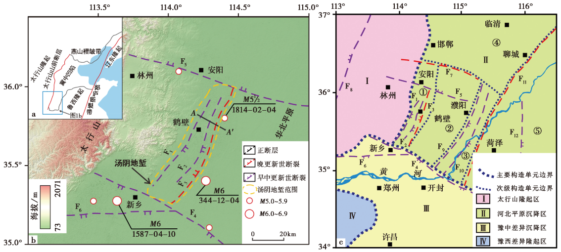
Fig. 1 Topography, geomorphology, and tectonic division map of active fault detection target area in Hebi City(Fig. 1c modified from WANG Zhi-shuo, 2017).
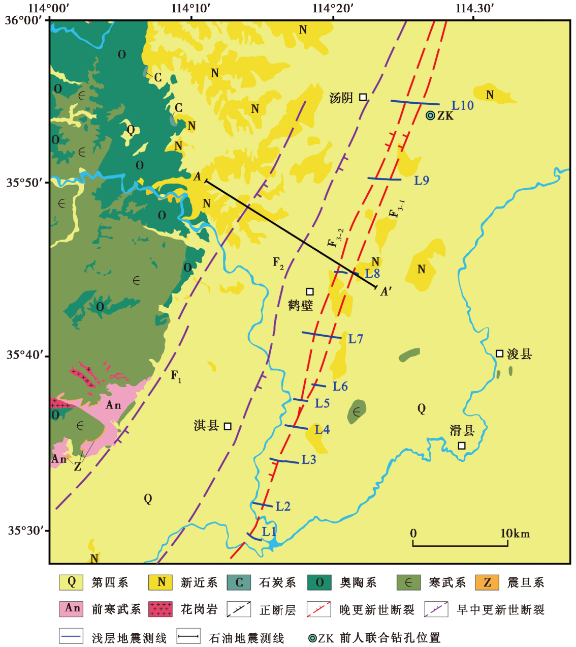
Fig. 2 Geological characteristics and location of seismic reflection profiles in target region of active fault detection.
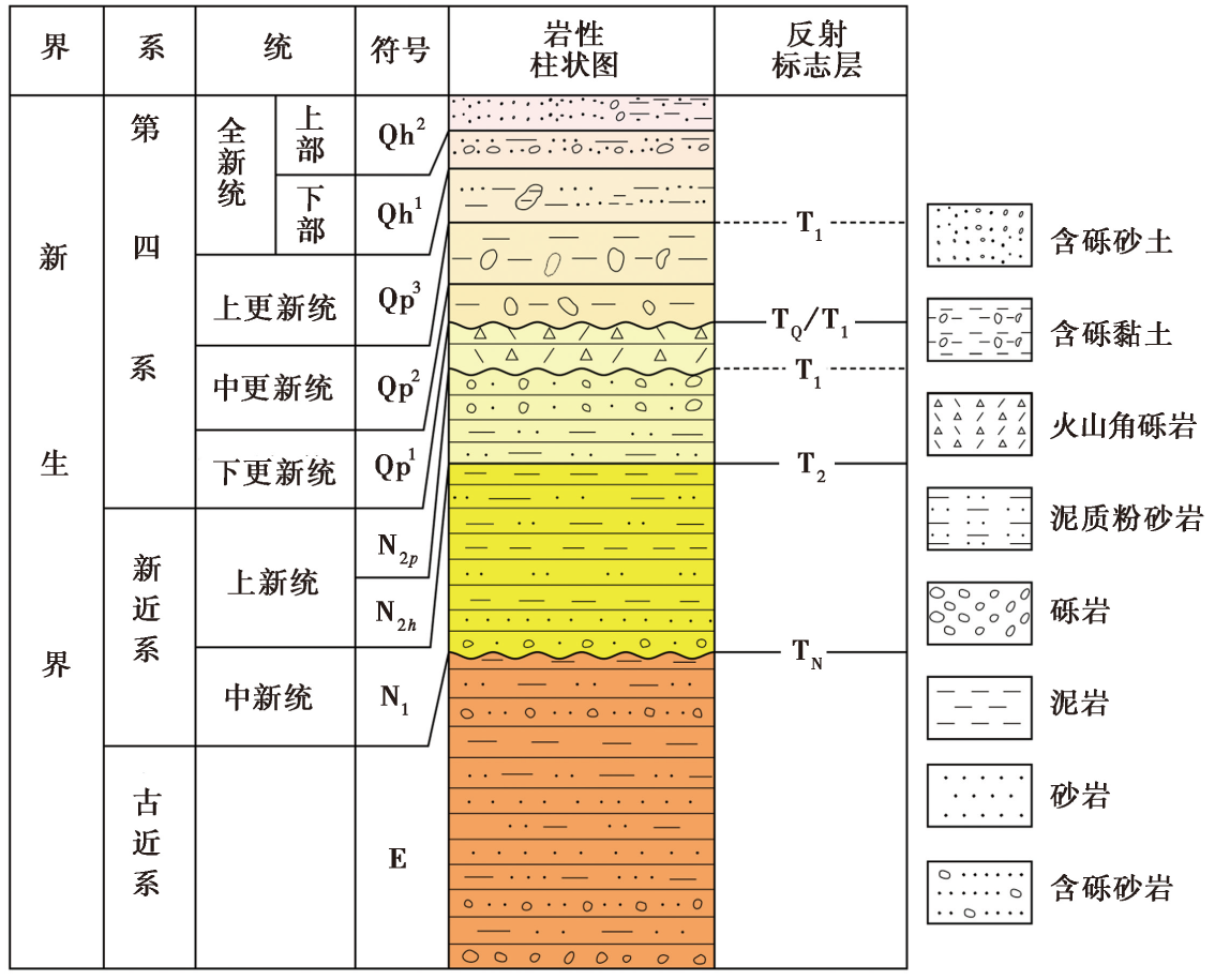
Fig. 3 Cenozoic Lithologic and stratigraphic column of the Tangyin Graben.
| 项 | 类别 | 参数 |
|---|---|---|
| 设备型号 | 仪器型号 | Geode DZ200 |
| 震源型号 | M18/612HD | |
| 检波器主频/Hz | 60 | |
| 震源激发 | 扫描频率/Hz | 10~120或8~90 |
| 扫描长度/s | 12 | |
| 最大出力/kN | 225 | |
| 记录 | 采样间隔/ms | 0.5 |
| 记录长度/ms | 2000 | |
| 观测系统 | 探测方向 | WE或EW |
| 道间距/m | 2 | |
| 炮间距/m | 6或8 | |
| 接收道数 | 240 | |
| 偏移距范围/m | 10~488或0~318 | |
| 覆盖次数 | 40或30 |
Table1 Shallow seismic data acquisition and observation system parameters
| 项 | 类别 | 参数 |
|---|---|---|
| 设备型号 | 仪器型号 | Geode DZ200 |
| 震源型号 | M18/612HD | |
| 检波器主频/Hz | 60 | |
| 震源激发 | 扫描频率/Hz | 10~120或8~90 |
| 扫描长度/s | 12 | |
| 最大出力/kN | 225 | |
| 记录 | 采样间隔/ms | 0.5 |
| 记录长度/ms | 2000 | |
| 观测系统 | 探测方向 | WE或EW |
| 道间距/m | 2 | |
| 炮间距/m | 6或8 | |
| 接收道数 | 240 | |
| 偏移距范围/m | 10~488或0~318 | |
| 覆盖次数 | 40或30 |
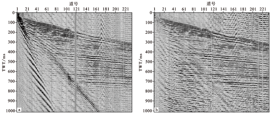
Fig. 4 Comparison of seismograms before(a) and after(b)de-noising processing.
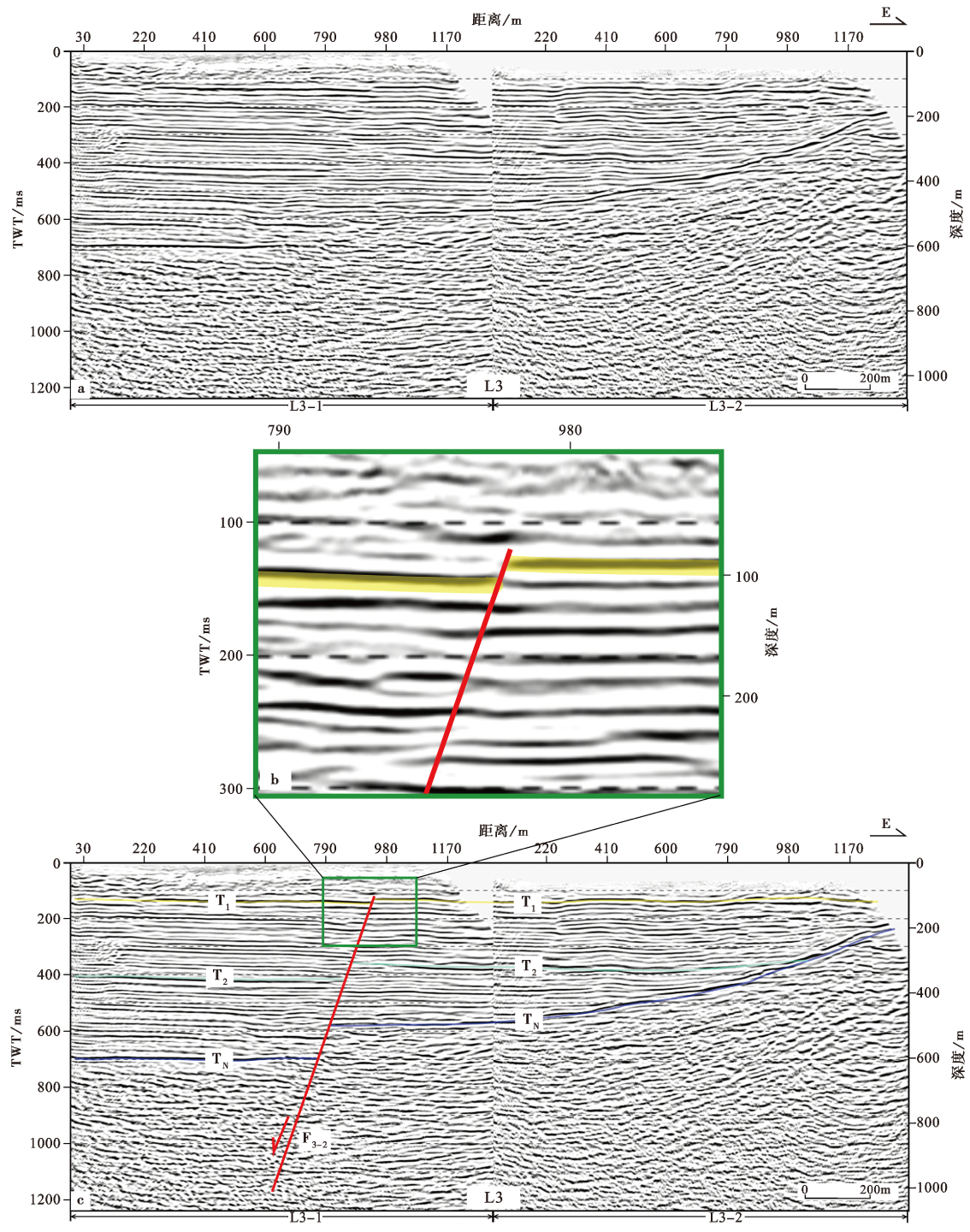
Fig. 5 Shallow seismic reflection stacking profile interpretation of lines L3.

Fig. 6 Shallow seismic reflection stacking profile interpretation of lines L1, L4 and L2.
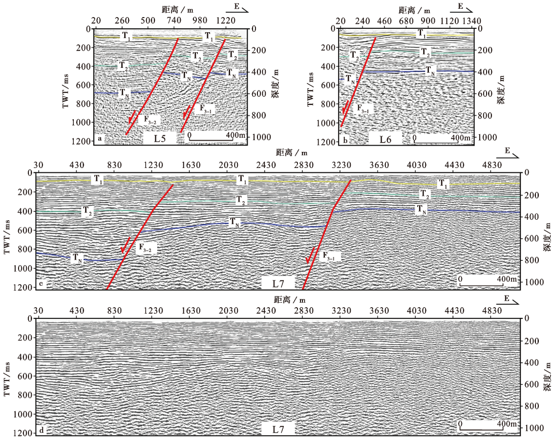
Fig. 7 Shallow seismic reflection stacking profile interpretation of lines L5, L6 and L7.
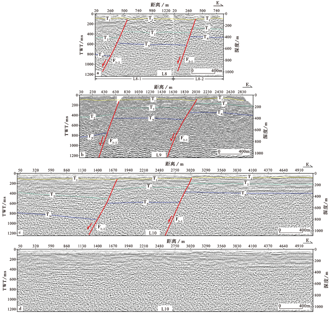
Fig. 8 Shallow seismic reflection stacking profile interpretation of lines L8, L9 and L10.
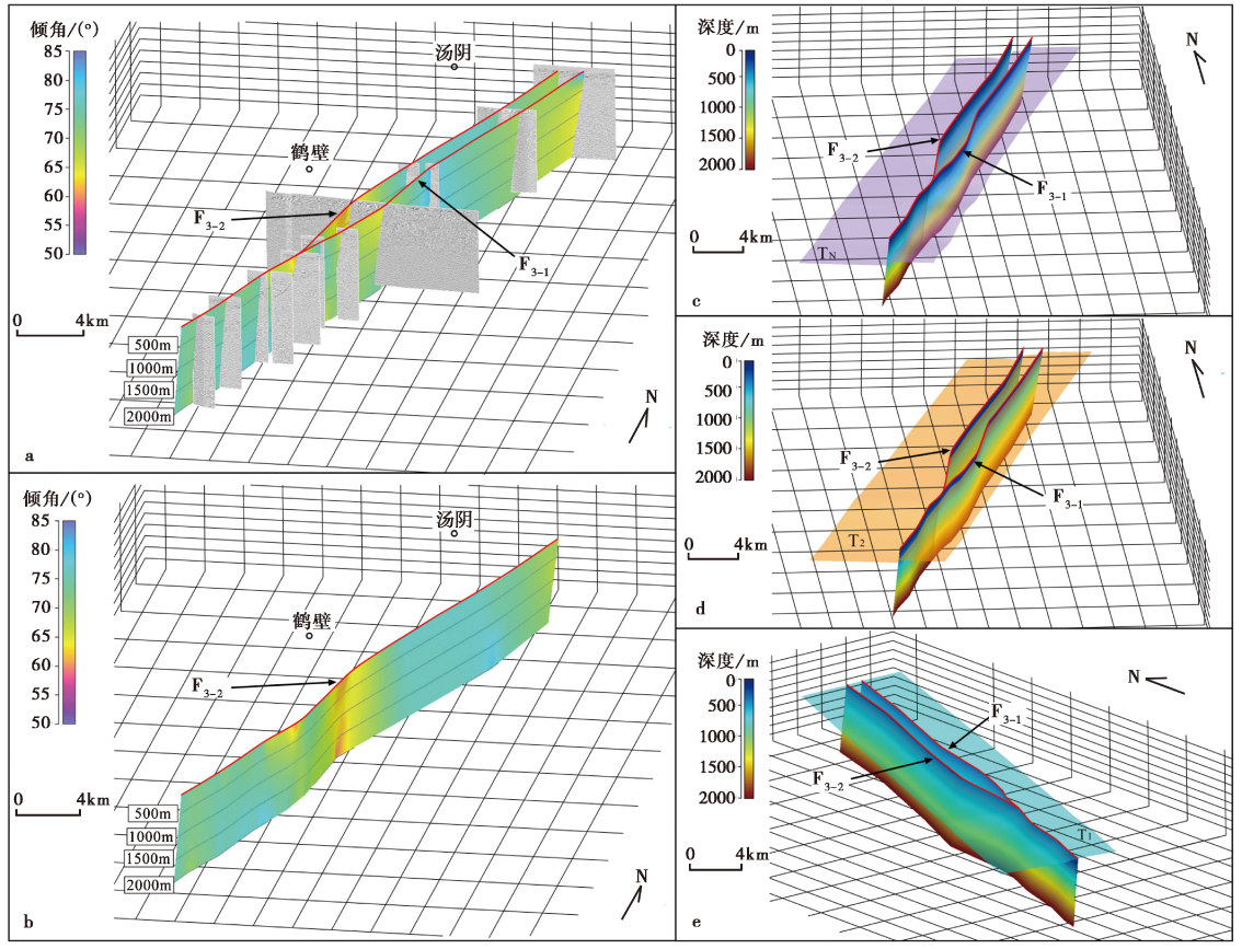
Fig. 9 3D structure and model of the Tangdong Fault.
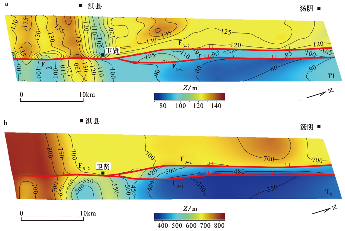
Fig. 10 Depth contour maps of T1 and TN layers of the Tangdong Fault.
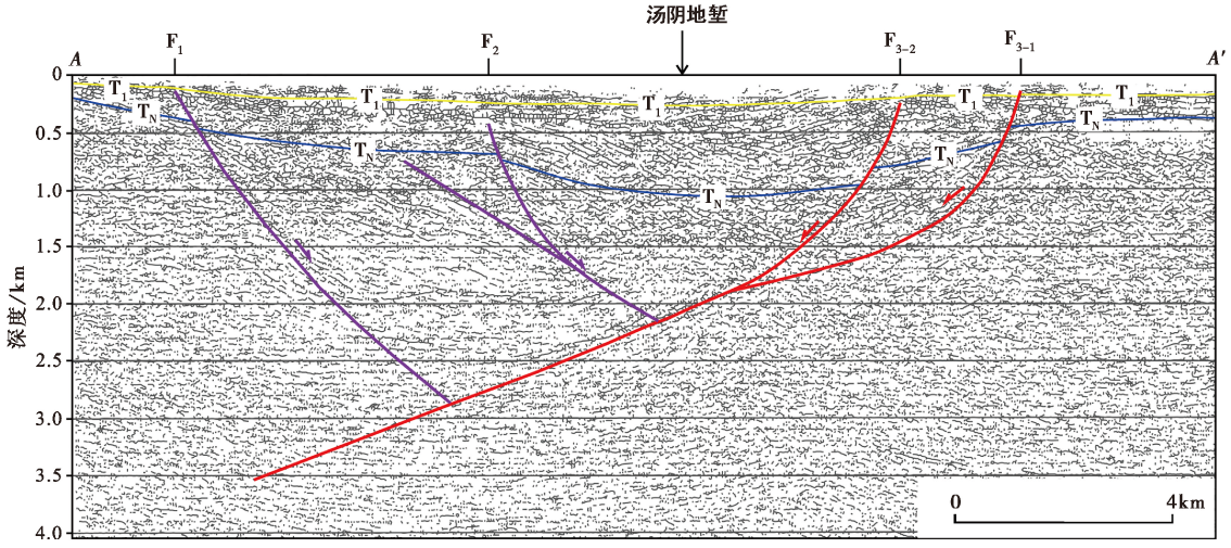
Fig. 11 Interpretation map of oil seismic profile across the Tangyin Graben.
| 断裂 | 测线名称 | |||||||||
|---|---|---|---|---|---|---|---|---|---|---|
| L1 | L2 | L3 | L4 | L5 | L6 | L7 | L8 | L9 | L10 | |
| F3-2 | √ | × | √ | √ | √ | × | × | × | √ | |
| F3-1 | × | × | √ | √ | √ | √ | ||||
Table2 T1 interface of the east and west branches of the Tangdong Fault
| 断裂 | 测线名称 | |||||||||
|---|---|---|---|---|---|---|---|---|---|---|
| L1 | L2 | L3 | L4 | L5 | L6 | L7 | L8 | L9 | L10 | |
| F3-2 | √ | × | √ | √ | √ | × | × | × | √ | |
| F3-1 | × | × | √ | √ | √ | √ | ||||
| [1] |
柴炽章, 孟广魁, 杜鹏, 等. 2006. 隐伏活动断层的多层次综合探测: 以银川隐伏活动断层为例[J]. 地震地质, 28(4): 536-546.
|
|
|
|
| [2] |
方盛明, 张先康, 刘保金, 等. 2002. 探测大城市活断层的地球物理方法[J]. 地震地质, 24(4): 606-613.
|
|
|
|
| [3] |
顾勤平, 康清清, 许汉刚, 等. 2013. 薄覆盖层地区隐伏断层及其上断点探测的地震方法技术: 以废黄河断层为例[J]. 地球物理学报, 56(5): 1609-1618.
|
|
|
|
| [4] |
顾勤平, 许汉刚, 赵启光. 2015. 厚覆盖层地区隐伏活断层探测的地震方法技术: 以桥北镇-宿迁断层为例[J]. 物探与化探, 39(2): 408-415.
|
|
|
|
| [5] |
顾勤平, 杨浩, 赵启光, 等, 2019. 金坛-如皋断裂北东段浅层地震勘探新证据[J]. 地震地质, 41(3): 743-758. doi: 10.3969/j.issn.0253-4967.2019.03.013.
|
|
DOI |
|
| [6] |
韩慕康, 赵景珍. 1980. 河南汤阴地堑的地震地质特征与地震危险性[J]. 地震地质, 2(4): 47-58.
|
|
|
|
| [7] |
韩慕康, 朱世龙, 赵景珍, 等. 1983. 太行山东麓断裂带南段第四纪构造应力场的地貌表现[J]. 地理学报, 38(4): 348-357.
DOI |
|
DOI |
|
| [8] |
韩竹军, 徐杰, 冉勇康, 等. 2003. 华北地区活动地块与强震活动[J]. 中国科学(D辑), 33(S1): 108-118.
|
|
|
|
| [9] |
何登发, 单帅强, 张煜颖, 等. 2018. 雄安新区的三维地质结构: 来自反射地震资料的约束[J]. 中国科学(地球科学), 48(9): 1207-1222.
|
|
|
|
| [10] |
河南省地质矿产局. 1989. 河南省区域地质志[M]. 北京: 地质出版社: 280-292.
|
|
Bureau of Geology and Mineral of Henan Province. 1989. Regional Geology of Henan Province[M]. Geological Publishing House, Beijing: 280-292 (in Chinese).
|
|
| [11] |
花鑫升, 酆少英, 姬计法, 等. 2020. 用地震反射剖面研究汤阴地堑上地壳结构与断裂特征[J]. 震灾防御技术, 15(4): 811-820.
|
|
|
|
| [12] |
花鑫升, 石金虎, 谭雅丽, 等. 2018. 浅层地震勘探资料揭示汤东断裂特征[J]. 震灾防御技术, 13(2): 276-283.
|
|
|
|
| [13] |
李彦宝, 冉勇康. 2011. 汤东断裂晚第四纪活动性钻孔联合剖面探测[C]//中国地球物理学会主编. 中国地球物理学会第二十七届年会论文集. 合肥: 中国科学技术大学出版社: 174.
|
|
|
|
| [14] |
刘保金, 柴炽章, 酆少英, 等. 2008. 第四纪沉积区断层及其上断点探测的地震方法技术: 以银川隐伏活动断层为例[J]. 地球物理学报, 51(5): 1475-1483.
|
|
|
|
| [15] |
刘保金, 何宏林, 石金虎, 等. 2012. 太行山东缘汤阴地堑地壳结构和活动断裂探测[J]. 地球物理学报, 55(10): 3266-3276.
|
|
|
|
| [16] |
刘尧兴, 周庆, 荆智国, 等, 2001. 豫北地区新构造活动特征及中长期地震预报研究[M]. 西安: 西安地图出版社: 82-84.
|
|
|
|
| [17] |
彭白, 苏鹏, 鲁人齐, 等. 2022. 浅层人工地震和地质雷达在城市活动断层探测中的联合应用: 以鹤壁市汤东断裂为例[J]. 震灾防御技术, 17(2): 269-277.
|
|
|
|
| [18] |
秦晶晶, 石金虎, 张毅, 等. 2018. 郯庐断裂带合肥段五河-合肥断裂构造特征[J]. 地球物理学报, 61(11): 4475-4485.
DOI |
|
|
|
| [19] |
任青芳, 张先康. 1998. 汤阴地堑及邻区的壳幔结构与地震危险性[J]. 中国地震, 14(2): 157-166.
|
|
|
|
| [20] |
王金艳, 鲁人齐, 张浩, 等. 2020. 郯庐断裂带江苏段新生界三维地质构造建模[J]. 地震学报, 42(2): 216-230.
|
|
|
|
| [21] |
王志铄. 2017. 河南省地震构造特征[M]. 北京: 地震出版社: 7-23.
|
|
|
|
| [22] |
许汉刚, 范小平, 冉勇康, 等. 2016. 郯庐断裂带宿迁段F5断裂浅层地震勘探新证据[J]. 地震地质, 38(1): 31-43. doi: 10.3969/j.issn.0253-4967.2016.01.003.
|
|
DOI |
|
| [23] |
徐杰, 高战武, 宋长青, 等. 2000. 太行山山前断裂带的构造特征[J]. 地震地质, 22(2): 111-122.
|
|
|
|
| [24] |
徐增波, 刘保金, 姬计法, 等. 2019. 太行山南端浅层速度结构成像和隐伏断裂探测[J]. 大地测量与地球动力学, 39(1): 88-92.
|
|
|
|
| [25] |
杨承先. 1984. 邯郸、 汤阴断陷地质结构及其活动性[J]. 地震地质, 6(3): 59-66.
|
|
|
|
| [26] |
于慎谔, 赵俊香, 杨承先. 2012. 太行东断裂的性状与分布[J]. 中国地震, 28(1): 78-87.
|
|
|
|
| [27] |
张成科, 赵金仁, 任青芳, 等. 1994. 豫北及其外围地区地壳上地幔结构研究[J]. 地震地质, 16(3): 243-253.
|
|
|
|
| [28] |
DOI URL |
| [29] |
|
| [30] |
DOI URL |
| [31] |
DOI URL |
| [32] |
DOI URL |
| [33] |
|
| [34] |
|
| [35] |
|
| [36] |
DOI URL |
| [37] |
DOI URL |
| [38] |
DOI URL |
| [39] |
DOI URL |
| [40] |
DOI URL |
| [1] | TIAN Yi-ming, YANG Zhuo-xin, WANG Zhi-shuo, SHI Jin-hu, ZHANG Yang, TAN Ya-li, ZHANG Jian-zhi, SONG Wei, JI Tong-yu. A PRELIMINARY STUDY OF THE SHALLOW EXPLORATION AND QUATERNARY ACTIVITIES OF THE FENGQIU SEGMENT OF THE XINXIANG-SHANGQIU FAULT [J]. SEISMOLOGY AND GEOLOGY, 2023, 45(1): 139-152. |
| Viewed | ||||||
|
Full text |
|
|||||
|
Abstract |
|
|||||
Copyright © SEISMOLOGY AND GEOLOGY, All Rights Reserved.
Tel: 010-62009049/9063 E-mail: dzdz@ies.ac.cn
Powered by Beijing Magtech Co., Ltd.