
SEISMOLOGY AND GEOLOGY ›› 2025, Vol. 47 ›› Issue (6): 1625-1648.DOI: 10.3969/j.issn.0253-4967.2025.06.20240062
Previous Articles Next Articles
CHARACTERISTICS OF GRAVITY CHANGE BEFORE THE 2021 YUNNAN YANGBI MS6.4 EARTHQUAKE AND ITS DEEP MATERIAL MIGRATION PROCESS
LIU Zhi-hui1,2)( ), HAO Hong-tao1,2),*(), HU Min-zhang1,2), LI Zhong-ya1,2), WANG Jian1,2), ZHANG Xin-lin1,2), WANG Jia-pei1,2)
- 1) Key Laboratory of Earthquake Geodesy, Institute of Seismology, China Earthquake Administration, Wuhan 430071, China
2) Hubei Earthquake Agency, Wuhan 430071, China
-
Received:2024-04-28Revised:2024-08-15Online:2025-12-20Published:2025-12-31
2021年云南漾濞6.4级地震前的重力变化特征及其深部物质迁移过程探析
刘志惠1,2)(), 郝洪涛1,2),*(), 胡敏章1,2), 李忠亚1,2), 汪健1,2), 张新林1,2), 王嘉沛1,2)
- 1) 中国地震局地震研究所, 地震大地测量重点实验室, 武汉 430071
2) 湖北省地震局, 武汉 430071
-
通讯作者:*郝洪涛, 男, 1981年生, 博士, 副研究员, 主要从事流动重力观测技术研究, E-mail: haoht2004@sina.com。 -
作者简介:刘志惠, 男, 1999年生, 现为中国地震局地震研究所固体地球物理学专业在读硕士研究生, 主要从事地震重力学研究, E-mail: lzh1779817654@163.com。
-
基金资助:中国地震局地震研究所基本科研业务专项(IS202326342)
Cite this article
LIU Zhi-hui, HAO Hong-tao, HU Min-zhang, LI Zhong-ya, WANG Jian, ZHANG Xin-lin, WANG Jia-pei. CHARACTERISTICS OF GRAVITY CHANGE BEFORE THE 2021 YUNNAN YANGBI MS6.4 EARTHQUAKE AND ITS DEEP MATERIAL MIGRATION PROCESS[J]. SEISMOLOGY AND GEOLOGY, 2025, 47(6): 1625-1648.
刘志惠, 郝洪涛, 胡敏章, 李忠亚, 汪健, 张新林, 王嘉沛. 2021年云南漾濞6.4级地震前的重力变化特征及其深部物质迁移过程探析[J]. 地震地质, 2025, 47(6): 1625-1648.
share this article
Add to citation manager EndNote|Ris|BibTeX
URL: https://www.dzdz.ac.cn/EN/10.3969/j.issn.0253-4967.2025.06.20240062
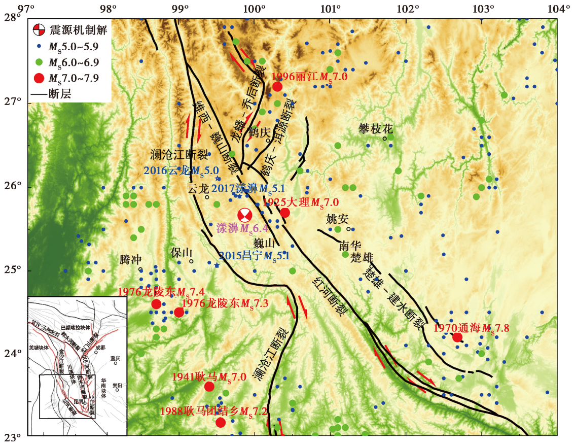
Fig. 1 Seismotectonic map of western Yunnan region.
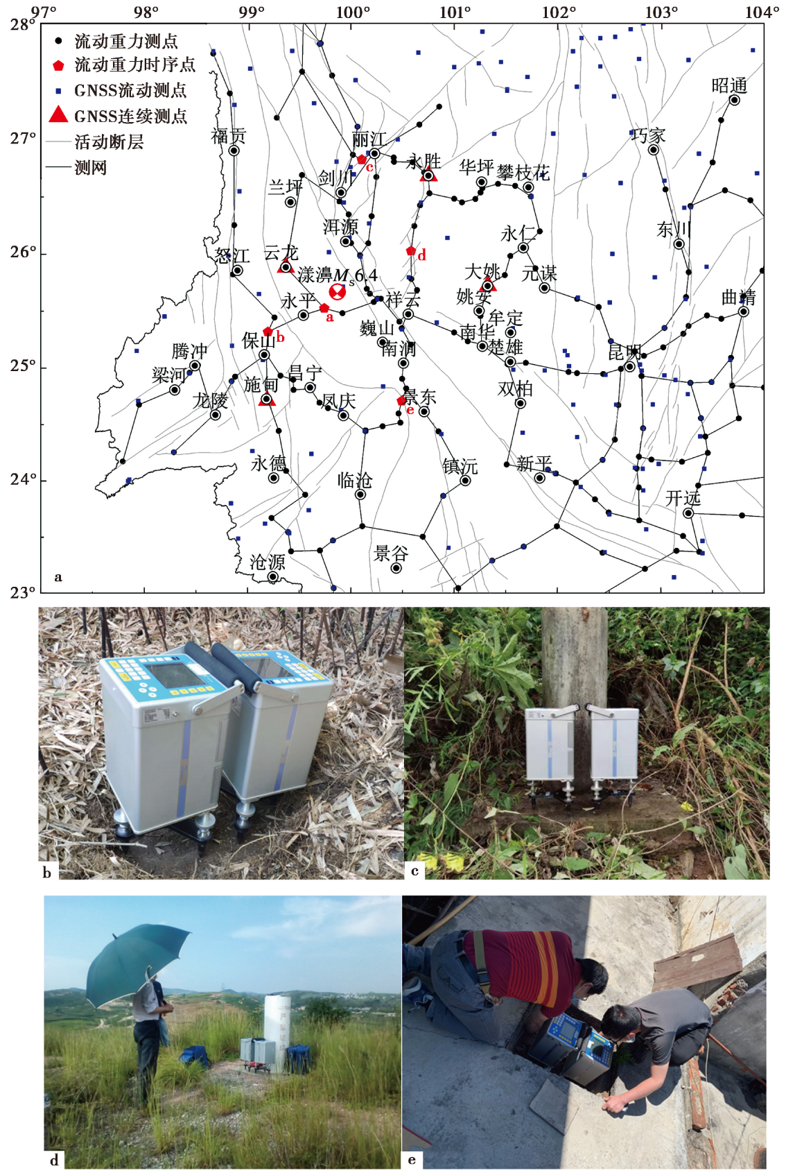
Fig. 2 Location of mobile gravity observation sites(a) and field observation sites of: Changyi(b), Pingpo(c), Huaping(d) and Shilin(e).
| 观测年月 | 采用仪器 | 格值系数 | 点值平均精度 /μGal | 后验中误差 /μGal | ||
|---|---|---|---|---|---|---|
| C169 | C170 | |||||
| 2015-09 | C169、C170 | 1.000098 | 1.000040 | 8.4 | 7.0 | |
| 2016-09 | C169、C170 | 1.000006 | 1.000066 | 8.3 | 8.5 | |
| 2017-09 | C169、C170 | 1.000058 | 1.000116 | 9.1 | 8.8 | |
| 2018-09 | C169、C170 | 1.000250 | 0.999980 | 10.0 | 9.6 | |
| 2019-09 | C169、C170 | 1.000240 | 1.000020 | 7.9 | 11.5 | |
| 2020-09 | C169、C170 | 1.000435 | 1.000109 | 9.3 | 10 | |
| 2021-04 | C169、C170 | 1.000405 | 1.000127 | 10.5 | 11.5 | |
Table1 Results of mobile gravity leveling observation in western Yunnan region
| 观测年月 | 采用仪器 | 格值系数 | 点值平均精度 /μGal | 后验中误差 /μGal | ||
|---|---|---|---|---|---|---|
| C169 | C170 | |||||
| 2015-09 | C169、C170 | 1.000098 | 1.000040 | 8.4 | 7.0 | |
| 2016-09 | C169、C170 | 1.000006 | 1.000066 | 8.3 | 8.5 | |
| 2017-09 | C169、C170 | 1.000058 | 1.000116 | 9.1 | 8.8 | |
| 2018-09 | C169、C170 | 1.000250 | 0.999980 | 10.0 | 9.6 | |
| 2019-09 | C169、C170 | 1.000240 | 1.000020 | 7.9 | 11.5 | |
| 2020-09 | C169、C170 | 1.000435 | 1.000109 | 9.3 | 10 | |
| 2021-04 | C169、C170 | 1.000405 | 1.000127 | 10.5 | 11.5 | |
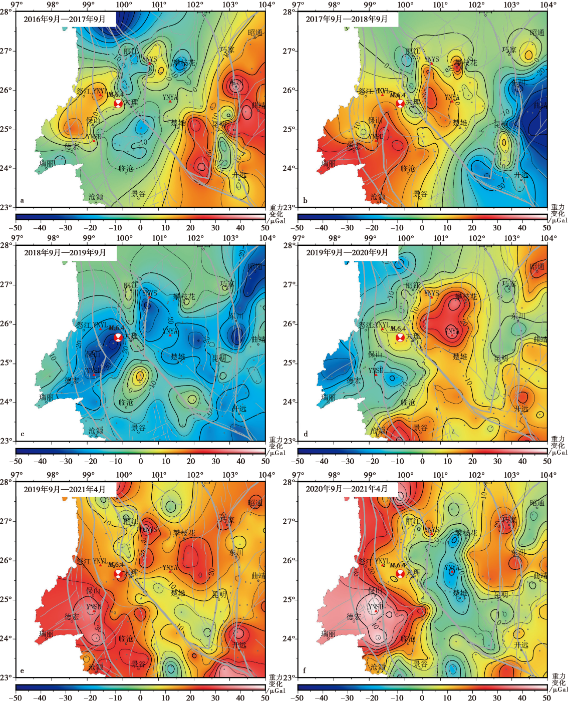
Fig. 3 Differential evolution of the gravity field in western Yunnan region prior to the M6.4 Yangbi earthquake.
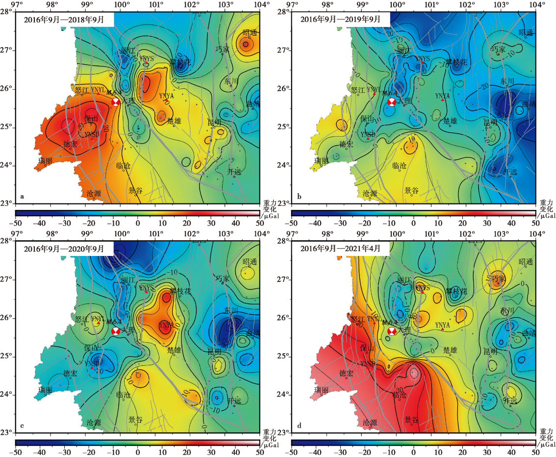
Fig. 4 Cumulative gravity change before the Yangbi MS6.4 earthquake in western Yunnan region.
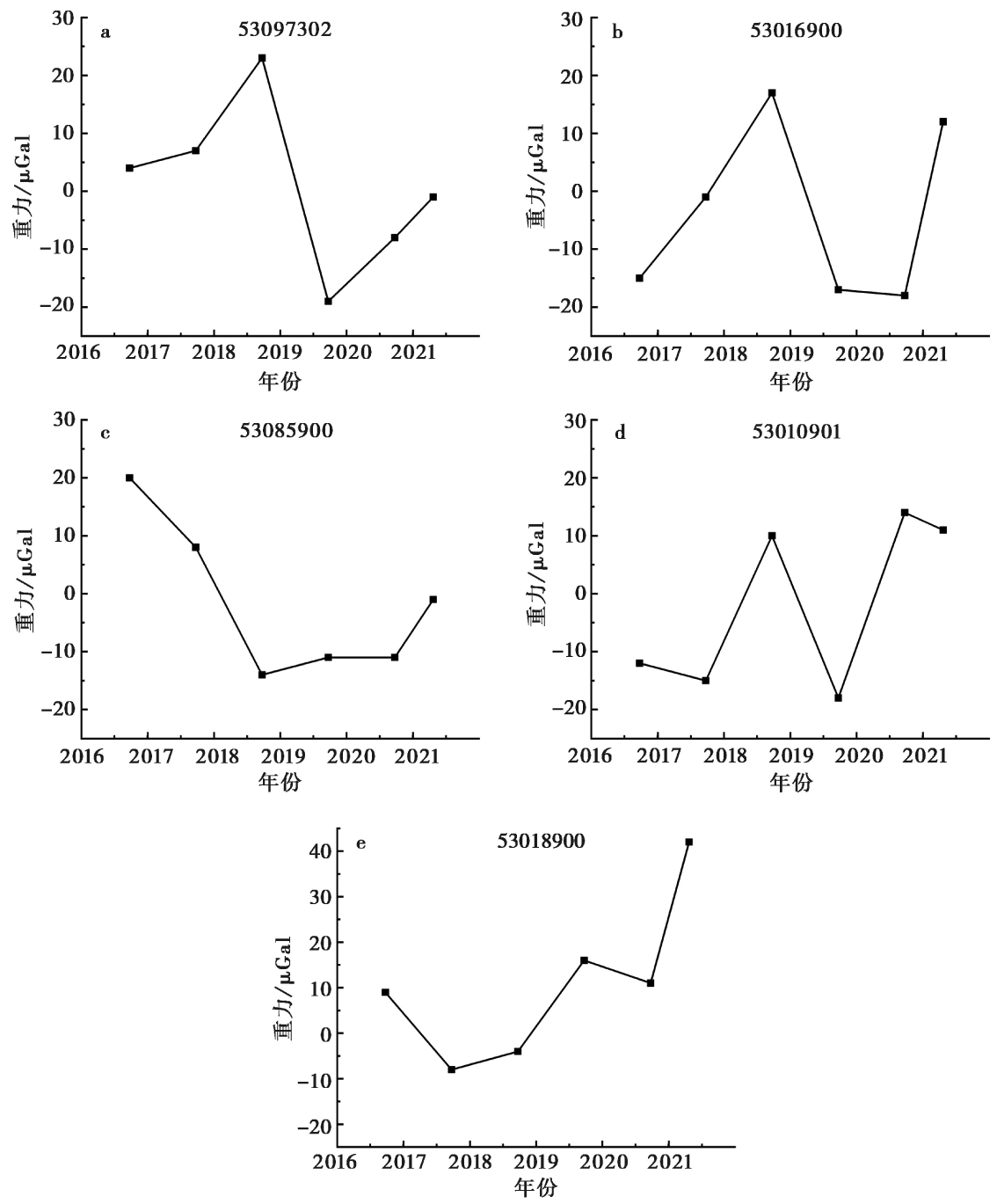
Fig. 5 Temporal variation of gravity point values near the epicenter.
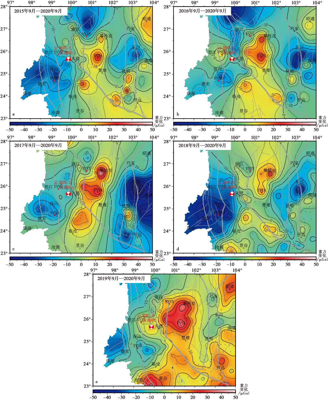
Fig. 6 Inter-annual variations of gravity from 1~5a intervals before the earthquake.
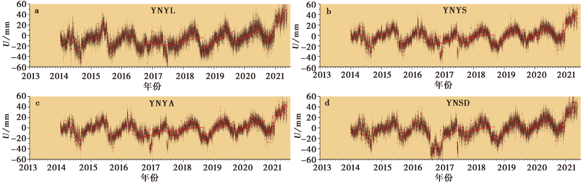
Fig. 7 Sequence of co-seismic displacements at continuous stations.
| 站点 | 类别 | 2016-09-2017-09 | 2017-09-2018-09 | 2018-09-2019-09 | 2019-09-2020-09 | 2020-09-2021-04 |
|---|---|---|---|---|---|---|
| YNYL | 形变量/mm | -4.33 | 9.03 | 32.85 | 25.46 | 66.58 |
| 重力变化/μGal | 0.85 | -1.78 | -6.46 | -5.01 | -13.1 | |
| YNYS | 形变量/mm | 16.32 | 7.49 | 26.87 | 21.37 | 61.75 |
| 重力变化/μGal | -3.2 | -1.47 | -5.29 | -4.20 | -12.14 | |
| YNYA | 形变量/mm | 15.87 | 10.98 | 25.74 | 19.45 | 60.86 |
| 重力变化/μGal | -3.12 | -2.16 | -5.06 | -3.83 | -11.97 | |
| YNSD | 形变量/mm | 41.09 | 11.13 | 34.93 | 22.74 | 62.1 |
| 重力变化/μGal | -8.08 | -2.19 | -6.87 | -4.47 | -12.22 |
Table2 GNSS inter-annual vertical displacements and gravity effects at each permanent station
| 站点 | 类别 | 2016-09-2017-09 | 2017-09-2018-09 | 2018-09-2019-09 | 2019-09-2020-09 | 2020-09-2021-04 |
|---|---|---|---|---|---|---|
| YNYL | 形变量/mm | -4.33 | 9.03 | 32.85 | 25.46 | 66.58 |
| 重力变化/μGal | 0.85 | -1.78 | -6.46 | -5.01 | -13.1 | |
| YNYS | 形变量/mm | 16.32 | 7.49 | 26.87 | 21.37 | 61.75 |
| 重力变化/μGal | -3.2 | -1.47 | -5.29 | -4.20 | -12.14 | |
| YNYA | 形变量/mm | 15.87 | 10.98 | 25.74 | 19.45 | 60.86 |
| 重力变化/μGal | -3.12 | -2.16 | -5.06 | -3.83 | -11.97 | |
| YNSD | 形变量/mm | 41.09 | 11.13 | 34.93 | 22.74 | 62.1 |
| 重力变化/μGal | -8.08 | -2.19 | -6.87 | -4.47 | -12.22 |

Fig. 8 Distribution of vertical uplift rate in western Yunnan.
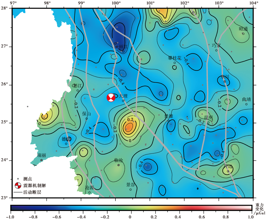
Fig. 9 Vertical gravity changes from September 2016 to September 2017.
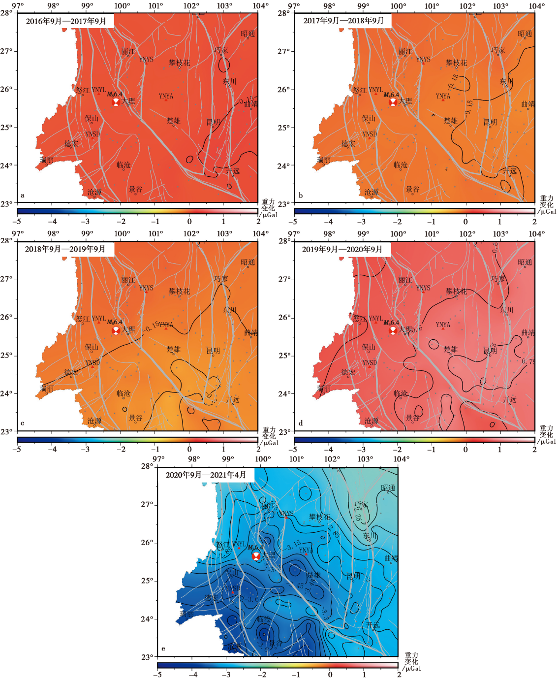
Fig. 10 Inter-annual differential hydrological effect.
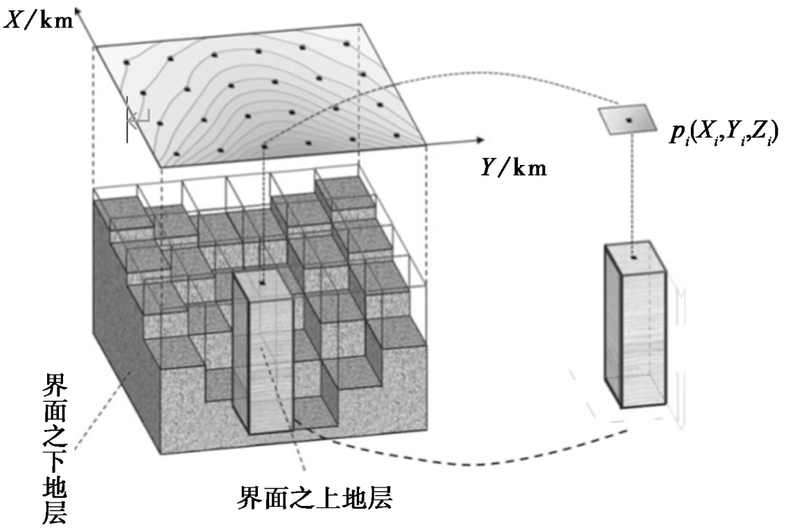
Fig. 11 Schematic diagram of density interface inversion(Martins et al., 2011).
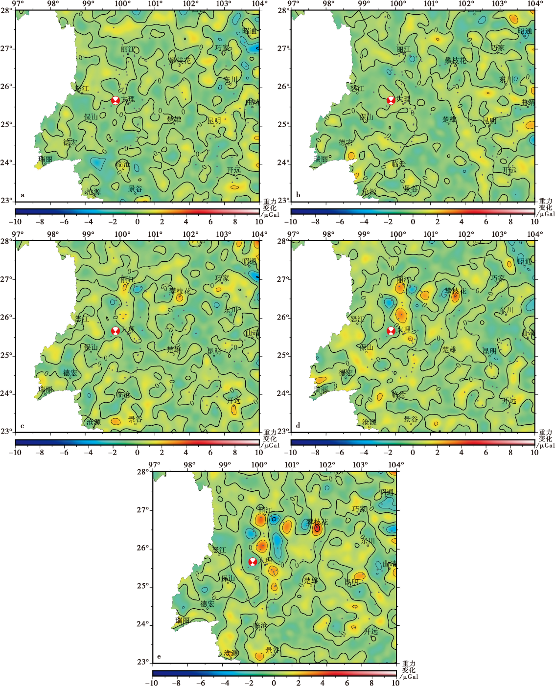
Fig. 12 Residual plots of the inversion results against the input gravity anomalies.
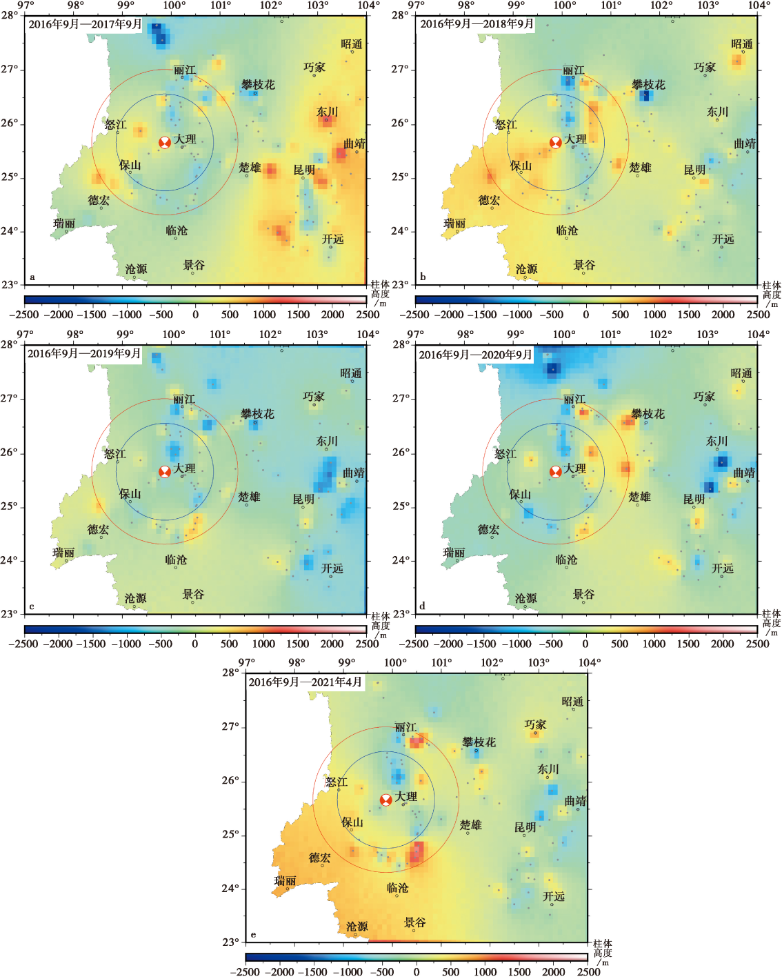
Fig. 13 Cumulative column height changes since 2016.
| [1] |
陈运泰, 顾浩鼎, 卢造勋. 1980. 1975年海城地震与1976年唐山地震前后的重力变化[J]. 地震学报, (1): 21-31.
|
|
|
|
| [2] |
陈智梁, 张选阳, 沈凤, 等. 1999. 中国西南地区地壳运动的GPS监测[J]. 科学通报, 44(8): 851-854.
|
|
|
|
| [3] |
段梦乔, 赵翠萍, 周连庆, 等. 2021. 2021年5月21日云南漾濞 MS6.4 地震序列发震构造[J]. 地球物理学报, 64(9): 3111-3125.
|
|
|
|
| [4] |
冯旭亮. 2016. 空间域密度界面三维反演方法研究[D]. 西安: 长安大学.
|
|
|
|
| [5] |
高家乙, 李永华, 王志铄, 等. 2022. 青藏高原东南缘地壳速度结构及云南漾濞 MS6.4 地震深部孕震环境[J]. 地球物理学报, 65(2): 604-619.
|
|
|
|
| [6] |
胡景, 赵韬, 白超英, 等. 2021. 2021年5月21日漾濞 MS6.4 地震震源区三维P和S波速度结构与地震重定位研究[J]. 地球物理学报, 64(12): 4488-4509.
DOI |
|
|
|
| [7] |
胡敏章, 郝洪涛, 李辉, 等. 2019. 地震分析预报的重力变化异常指标分析[J]. 中国地震, 35(3): 417-430.
|
|
|
|
| [8] |
黄江培, 曹颖, 刘东, 等. 2022. 漾濞 MS6.4 地震前后的重力变化特征及其孕震含义分析[J]. 地震地质, 44(6): 1557-1573. doi: 10.3969/j.issn.0253-4967.2022.06.012.
|
|
DOI |
|
| [9] |
贾民育, 邢灿飞, 孙少安. 1995. 滇西重力变化的二维图像及其与5级(MS)以上地震的关系[J]. 地壳形变与地震, (3): 9-19.
|
|
|
|
| [10] |
李瑞浩, 付兆珠, 孙和平. 1987. 唐山地震(M=7.8)前后的区域重力变化和扩容过程[J]. 内陆地震, (4): 426-434.
|
|
|
|
| [11] |
李煜航, 郝明, 季灵运, 等. 2014. 青藏高原东缘中南部主要活动断裂滑动速率及其地震矩亏损[J]. 地球物理学报, 57(4): 1062-1078.
|
|
|
|
| [12] |
刘东, 郝洪涛, 王青华, 等. 2021. 2021年云南漾濞 MS6.4 地震前重力变化[J]. 地震地质, 43(5): 1157-1170. doi: 10.3969/j.issn.0253-4967.2021.05.008.
|
|
DOI |
|
| [13] |
刘绍府, 刘冬至, 李辉. 1991. 高精度重力测量平差及其软件[J]. 地震, (4): 57-66.
|
|
|
|
| [14] |
申重阳, 谈洪波, 郝洪涛, 等. 2011. 2009年姚安 MS6.0 地震重力场前兆变化机理[J]. 大地测量与地球动力学, 31(2): 17-22, 47.
|
|
|
|
| [15] |
孙德梅, 闵志. 1984. 三维密度界面反演的一个近似方法[J]. 物探与化探, 8(2): 89-98.
|
|
|
|
| [16] |
王椿镛,
|
|
|
|
| [17] |
王青华, 郝洪涛, 汪健, 等. 2019. 云南地震流动重力监测网建设与映震能力分析[J]. 大地测量与地球动力学, 39(3): 317-324.
|
|
|
|
| [18] |
王阎昭, 王恩宁, 沈正康, 等. 2008. 基于GPS资料约束反演川滇地区主要断裂现今活动速率[J]. 中国科学(D辑), 38(5): 582-597.
|
|
|
|
| [19] |
王勇, 张为民, 詹金刚, 等. 2004. 重复绝对重力测量观测的滇西地区和拉萨点的重力变化及其意义[J]. 地球物理学报, 47(1): 95-100.
|
|
|
|
| [20] |
王月, 胡少乾, 何骁慧, 等. 2021. 2021年5月21日云南漾濞6.4级地震序列重定位及震源机制研究[J]. 地球物理学报, 64(12): 4510-4525.
DOI |
|
|
|
| [21] |
徐锡伟, 闻学泽, 郑荣章, 等. 2003. 川滇地区活动块体最新构造变动样式及其动力来源[J]. 中国科学(D辑), 33(S1): 151-162.
|
|
|
|
| [22] |
张克亮, 甘卫军, 梁诗明, 等. 2021. 2021年5月21日 MS6.4 漾濞地震GNSS同震变形场及其约束反演的破裂滑动分布[J]. 地球物理学报, 64(7): 2253-2266.
DOI |
|
|
|
| [23] |
张培震, 王伟涛, 甘卫军, 等. 2022. 青藏高原的现今构造变形与地球动力过程[J]. 地质学报, 96(10): 3297-3313.
|
|
|
|
| [24] |
郑秋月, 刘东, 杨薪俊, 等. 2022. 云南流动重力测网数据质量及场源分解[J]. 地球物理学报, 65(7): 3020-3031.
|
|
|
|
| [25] |
祝意青, 闻学泽, 孙和平, 等. 2013. 2013年四川芦山 MS7.0 地震前的重力变化[J]. 地球物理学报, 56(6): 1887-1894.
|
|
|
|
| [26] |
|
| [27] |
|
| [28] |
DOI URL |
| [29] |
DOI URL |
| [30] |
DOI URL |
| [31] |
|
| [32] |
DOI URL |
| [33] |
|
| [34] |
DOI URL |
| [35] |
|
| [36] |
DOI URL |
| [37] |
DOI URL |
| [38] |
|
| [39] |
DOI URL |
| [1] | ZHANG Yan, JI Zhi-wei, ZHAI Hong-yu, WU Chun-hao. GROUND MOTION SIMULATION CONSIDERING VELOCITY DISPERSION AND ITS IMPLICATIONS FOR SEISMIC HAZARD ASSESSMENT [J]. SEISMOLOGY AND GEOLOGY, 2024, 46(6): 1408-1425. |
| [2] | LI Shu-peng, HU Min-zhang, ZHU Yi-qing, HAO Hong-tao, YIN Hai-tao, JIA Yuan, CUI Hua-wei, LU Han-peng, ZHANG Gang, WANG Feng-ji, LIU Hong-liang. GRAVITY CHANGES BEFORE THE PINGYUAN MS5.5 EARTHQUAKE OF 2023 [J]. SEISMOLOGY AND GEOLOGY, 2024, 46(5): 1172-1191. |
| [3] | WANG Jia-pei, TAN Hong-bo, LI Zhong-ya, LIU Shao-ming, ZHANG Yi, HAO Hong-tao, HU Min-zhang, SHEN Chong-yang. CHARACTERISTICS AND RELATIONSHIP BETWEEN GRAVITY VARIATION AND CRUSTAL VERTICAL DEFORMATION BEFORE AND AFTER CHANGNING EARTHQUAKE [J]. SEISMOLOGY AND GEOLOGY, 2023, 45(4): 952-969. |
| [4] | WANG Jian, ZHANG Xin-lin, TAN Hong-bo, HU Min-zhang, WU Gui-ju, LI Zhong-ya, ZHANG Ming-hui. DETERMINATION OF GRAVITY VALUES FOR MULANSHAN CALIBRATION BASELINE AND ANALYSIS OF GRAVITY CHANGE [J]. SEISMOLOGY AND GEOLOGY, 2023, 45(2): 553-569. |
| [5] | FAN Wen-jie. CHARACTERISTICS OF TECTONIC STRESS FIELD AROUND THE YANGBI MS6.4 EARTHQUAKE AND ITS SURROUNDING AREAS ON MAY 21, 2021 AND ITS GEODYNAMIC IMPLICATION [J]. SEISMOLOGY AND GEOLOGY, 2023, 45(1): 208-230. |
| [6] | ZHANG Ke, WANG Xin, YANG Hong-ying, WANG Yue, XU Yan, LI Jing. THE CHARACTERISTICS AND SEISMOGENIC STRUCTURE ANALYSIS OF THE 2021 YANGBI MS6.4 EARTHQUAKE SEQUENCE, YUNNAN [J]. SEISMOLOGY AND GEOLOGY, 2023, 45(1): 231-251. |
| [7] | GOU Jia-ning, LIU Zi-wei, JIANG Ying, ZHANG Xiao-tong. GRAVITY PERTURBATION AND CHARACTERISTICS OF TEM-PORAL AND SPATIAL CHANGES OF BACKGROUND NOISE BE-FORE EARTHQUAKE: THE EXAMPLE OF MADUO MS7.4 AND YANGBI MS6.4 EARTHQUAKES [J]. SEISMOLOGY AND GEOLOGY, 2023, 45(1): 252-268. |
| [8] | WANG Jian, SHEN Chong-yang, SUN Wen-ke, TAN Hong-bo, HU Min-zhang, LIANG Wei-feng, HAN Yu-fei, ZHANG Xin-lin, WU Gui-ju, WANG Qing-hua. STUDY ON PRESENT GRAVITY CHANGE AND DEEP CRUST DEFORMATION IN THE NORTHERN AND MIDDLE SECTIONS OF THE RED RIVER FAULT ZONE [J]. SEISMOLOGY AND EGOLOGY, 2021, 43(6): 1537-1562. |
| [9] | GUO Shu-song, ZHU Yi-qing, XU Yun-ma, LIU Fang, ZHAO Yun-feng, ZHANG Guo-qing, ZHU Hui. GRAVITY EVIDENCE OF META-INSTABLE STATE BEFORE THE 2008 WENCHUAN EARTHQUAKE [J]. SEISMOLOGY AND EGOLOGY, 2021, 43(6): 1368-1380. |
| [10] | YANG Jian-wen, JIN Ming-pei, YE Beng, GAO Qiong, CHEN Jia, ZHANG Hua-ying, DENG Jia-mei. A STUDY ON THE REGIONAL WAVE VELOCITY CHANGES BEFORE THE MS6.4 YANGBI EARTHQUAKE USING AMBIENT NOISE [J]. SEISMOLOGY AND EGOLOGY, 2021, 43(5): 1171-1187. |
| [11] | LIU Dong, HAO Hong-tao, WANG Qing-hua, ZHENG Qiu-yue, HUANG Jiang-pei. GRAVITY FIELD CHANGE BEFORE THE 2021 YANGBI MS6.4 EARTHQUAKE, YUNNAN [J]. SEISMOLOGY AND EGOLOGY, 2021, 43(5): 1157-1170. |
| [12] | ZHANG Bin, LI Xiao-jun, RONG Mian-shui, YU Yan-xiang, WANG Yu-shi, WANG Ji-xin. ANALYSIS OF STRONG GROUND MOTION CHARACTERISTICS AND EARTHQUAKE DAMAGE FOR THE YANGBI MS6.4 EARTHQUAKE, YUNNAN [J]. SEISMOLOGY AND EGOLOGY, 2021, 43(5): 1127-1139. |
| [13] | WEI Jin, HAO Hong-tao, HAN Yu-fei, HU Min-zhang, JIANG Ying, LIU Zi-wei. STUDY ON THE CHARACTERISTICS OF CO-SEISMIC GRAVITY CHANGE INDUCED BY MADUO MS7.4 EARTHQUAKE BASED ON OBSERVATIONS OF CONTINUOUS GRAVITY STATIONS [J]. SEISMOLOGY AND EGOLOGY, 2021, 43(4): 984-998. |
| [14] | ZHANG Xin-lin, WANG Jian, HU Min-zhang, WANG Jia-pei, LI Zhong-ya, ZHANG Yi. GRAVITY VARIATION CHARACTERISTICS IN YUNNAN AND ITS SURROUNDING AREAS FROM 2010 TO 2020 [J]. SEISMOLOGY AND EGOLOGY, 2021, 43(4): 972-983. |
| [15] | SONG Cheng-ke, CHEN Zheng-yu, ZHOU Si-yuan, XU Yu-jian, CHEN Bin. GEOMAGNETIC FIELD CHANGE BEFORE AND AFTER 2021 YANGBI MS6.4 EARTHQUAKE [J]. SEISMOLOGY AND EGOLOGY, 2021, 43(4): 958-971. |
| Viewed | ||||||
|
Full text |
|
|||||
|
Abstract |
|
|||||
Copyright © SEISMOLOGY AND GEOLOGY, All Rights Reserved.
Tel: 010-62009049/9063 E-mail: dzdz@ies.ac.cn
Powered by Beijing Magtech Co., Ltd.