
SEISMOLOGY AND GEOLOGY ›› 2026, Vol. 48 ›› Issue (4): 959-980.DOI: 10.3969/j.issn.0253-4967.20250054
• Research paper • Previous Articles Next Articles
THREE-DIMENSIONAL GEOLOGICAL MODELING AND MECHANISM ANALYSIS OF WATER INJECTION-INDUCED SEISMICITY IN THE HUAI'AN SALT MINING AREA
CHENG Jia1)( ), WANG Qi-xin2), WANG Zi-yue1), XU Xi-wei1), CAI Jun-tao2), XU Zhi-ping3), YANG Yan-bing4), CHEN Xiao-bin2), LIU Qiao-xia3)
- 1)
School of Earth Sciences and Resources ,China University of Geosciences(Beijing)
2)National Institute of Natural Hazards ,Ministry of Emergency Management of China
3)Geophysical Exploration Center ,China Earthquake Administration
4)Earthquake Prevention and Disaster Reduction Service Center of Huai'an City
-
Received:2025-02-17Revised:2025-11-04Online:2026-09-09Published:2026-09-09
淮安盐矿三维构造模型及其注水诱发地震机制分析
程佳1)(), 王启欣2), 王子月1), 徐锡伟1), 蔡军涛2), 徐志萍3), 杨彦兵4), 陈小斌2), 刘巧霞3)
- 1)
中国地质大学(北京) ,地球科学与资源学院
2)应急管理部国家自然灾害防治研究院
3)中国地震局地球物理勘探中心
4)淮安市防震减灾服务中心
-
作者简介:程佳, 男, 1982年生, 2017年于中国地震局地质研究所获构造地质学专业博士学位, 教授, 主要从事活动断层与地震地质灾害的研究与应用。E-mail: jiacheng@cugb.edu.cn。
-
基金资助:国家自然科学基金(42474078); 国家自然科学基金(42074064); 科技部重点研发计划项目(2023XAGG0067); 中国地质大学(北京)活动构造与地震灾害链学科建设资金(2023010)

Cite this article
CHENG Jia, WANG Qi-xin, WANG Zi-yue, XU Xi-wei, CAI Jun-tao, XU Zhi-ping, YANG Yan-bing, CHEN Xiao-bin, LIU Qiao-xia. THREE-DIMENSIONAL GEOLOGICAL MODELING AND MECHANISM ANALYSIS OF WATER INJECTION-INDUCED SEISMICITY IN THE HUAI'AN SALT MINING AREA[J]. SEISMOLOGY AND GEOLOGY, 2026, 48(4): 959-980.
程佳, 王启欣, 王子月, 徐锡伟, 蔡军涛, 徐志萍, 杨彦兵, 陈小斌, 刘巧霞. 淮安盐矿三维构造模型及其注水诱发地震机制分析[J]. 地震地质, 2026, 48(4): 959-980.
share this article
Add to citation manager EndNote|Ris|BibTeX
URL: https://www.dzdz.ac.cn/EN/10.3969/j.issn.0253-4967.20250054
| 地层 | 视厚度 /m | 构造运动 | 岩性简述 | ||||
|---|---|---|---|---|---|---|---|
| 统 | 组 | 段 | 符号 | ||||
| 第四系 | 东台组 | Qd | 0~200 | 以细粉砂层与黏土层互层为主。 | |||
| 中上新统 | 盐城组 | Ny | 75~320 | 东台运动 | 以砂砾岩为主。 | ||
| 始新世 | 三垛组 | 上段 | E2s | 0~1190 | 三垛运动 | 粉砂岩,细砂岩夹薄层泥岩。 | |
| 下段 | 粉砂岩、细砂岩与泥岩互层,底为块状砂砾岩、含砾砂岩夹薄层泥岩。 | ||||||
| 戴南组 | E2d | 50~380 | 泥岩与粉砂岩互层,以泥岩、砂质泥岩为主。 | ||||
| 古新统 | 阜宁组 | 四段 | E1f | 50~350 | 吴堡运动 | 岩性为石盐岩、无水芒硝岩与泥岩;沉积相为浅湖—深湖相,岩性以泥岩为主,夹薄层灰岩、白云岩、油页岩,局部夹薄层粉砂岩条带。 | |
| 三段 | E1f | 100~300 | 石盐岩、膏石、膏质泥岩; | ||||
| 二段 | E1f | 130~375 | 上部为石岩盐,下部为灰质、膏质泥岩,石盐岩;次凹边缘为泥岩、砂岩 | ||||
| 一段 | E1f | 150~350 | 砂岩、粉砂岩、泥岩。 | ||||
| 上白垩统 | 泰州组 | 上段 | K2t | 100~200 | 红色砂岩夹泥岩、粉砂岩(其中新生代红砂岩是一种含可溶性盐较多的典型内陆湖相沉积,成岩时间晚,胶结性差;砂岩的矿物颗粒大且岩石的孔隙度大,对水的封闭性差,是储水地层)。 | ||
| 中下段 | 100~240 | 以泥岩为主,夹薄层灰岩(该泥岩是弱固结的黏土经过中等程度的后生作用形成强固结的岩石,矿物颗粒细小,胶结物为泥质胶结,胶结紧密,岩石的孔隙度低,封闭性强,是天然隔水层)。 | |||||
| 下段 | 100~200 | 含泥砾岩、块状砾岩等。 | |||||
Table1 Simplified stratigraphic sequence of the Cretaceous-Tertiary system in the Subei Basin(from FU Qiang et al., 2007)
| 地层 | 视厚度 /m | 构造运动 | 岩性简述 | ||||
|---|---|---|---|---|---|---|---|
| 统 | 组 | 段 | 符号 | ||||
| 第四系 | 东台组 | Qd | 0~200 | 以细粉砂层与黏土层互层为主。 | |||
| 中上新统 | 盐城组 | Ny | 75~320 | 东台运动 | 以砂砾岩为主。 | ||
| 始新世 | 三垛组 | 上段 | E2s | 0~1190 | 三垛运动 | 粉砂岩,细砂岩夹薄层泥岩。 | |
| 下段 | 粉砂岩、细砂岩与泥岩互层,底为块状砂砾岩、含砾砂岩夹薄层泥岩。 | ||||||
| 戴南组 | E2d | 50~380 | 泥岩与粉砂岩互层,以泥岩、砂质泥岩为主。 | ||||
| 古新统 | 阜宁组 | 四段 | E1f | 50~350 | 吴堡运动 | 岩性为石盐岩、无水芒硝岩与泥岩;沉积相为浅湖—深湖相,岩性以泥岩为主,夹薄层灰岩、白云岩、油页岩,局部夹薄层粉砂岩条带。 | |
| 三段 | E1f | 100~300 | 石盐岩、膏石、膏质泥岩; | ||||
| 二段 | E1f | 130~375 | 上部为石岩盐,下部为灰质、膏质泥岩,石盐岩;次凹边缘为泥岩、砂岩 | ||||
| 一段 | E1f | 150~350 | 砂岩、粉砂岩、泥岩。 | ||||
| 上白垩统 | 泰州组 | 上段 | K2t | 100~200 | 红色砂岩夹泥岩、粉砂岩(其中新生代红砂岩是一种含可溶性盐较多的典型内陆湖相沉积,成岩时间晚,胶结性差;砂岩的矿物颗粒大且岩石的孔隙度大,对水的封闭性差,是储水地层)。 | ||
| 中下段 | 100~240 | 以泥岩为主,夹薄层灰岩(该泥岩是弱固结的黏土经过中等程度的后生作用形成强固结的岩石,矿物颗粒细小,胶结物为泥质胶结,胶结紧密,岩石的孔隙度低,封闭性强,是天然隔水层)。 | |||||
| 下段 | 100~200 | 含泥砾岩、块状砾岩等。 | |||||
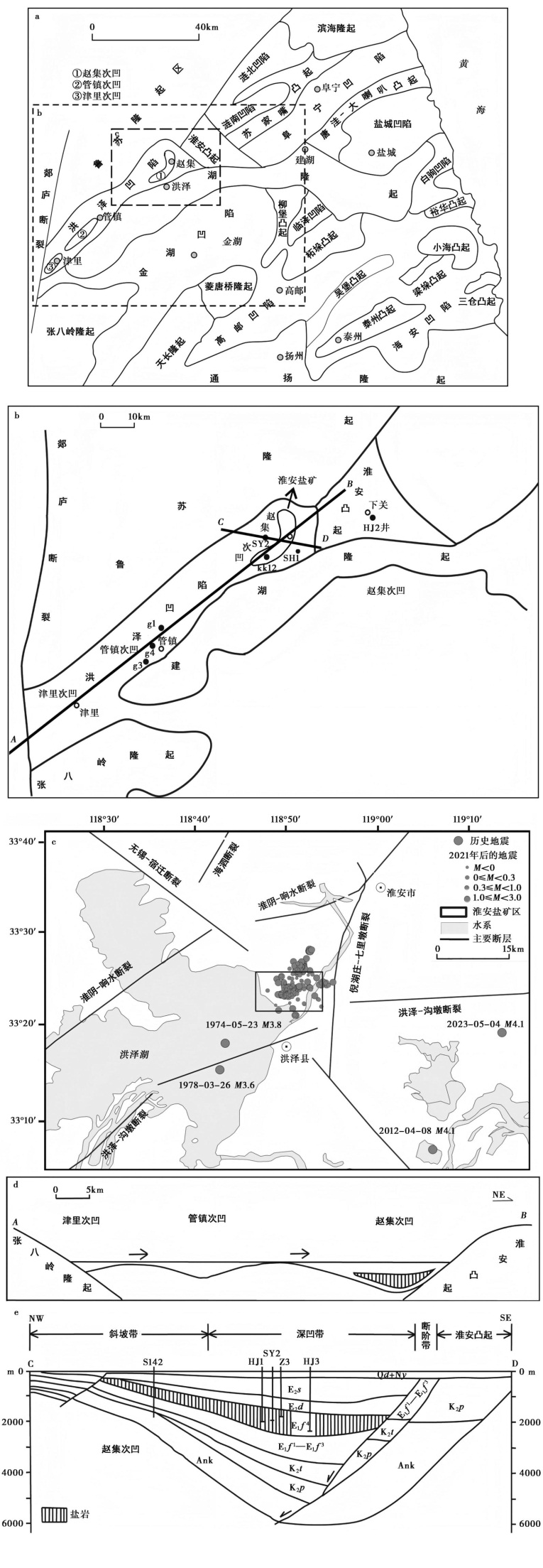
Fig. 1 Tectonic setting and seismicity distribution of the salt mine area and adjacent regions in the Zhaoji sub-depression, Subei Basin.
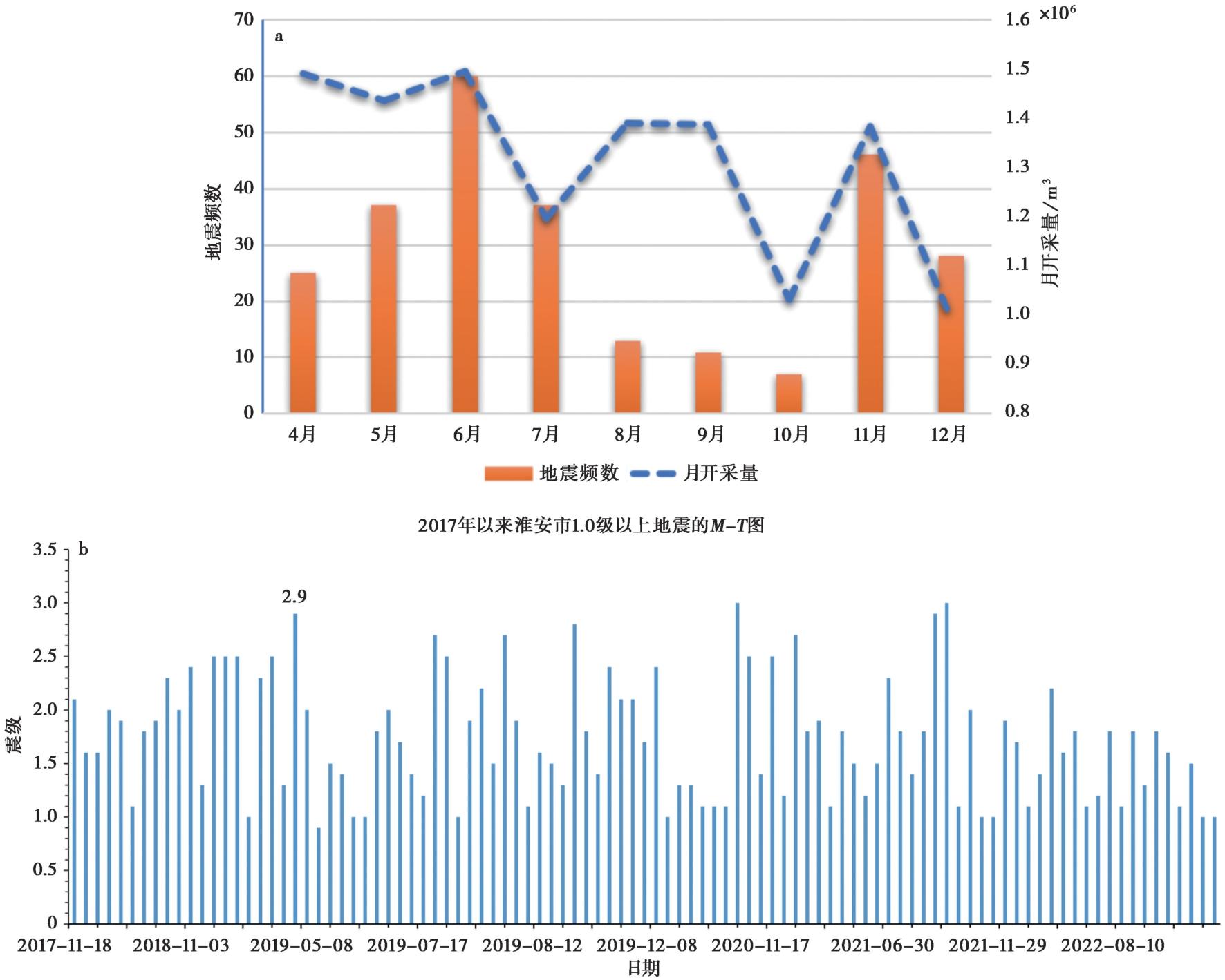
Fig. 2 Temporal evolution of seismicity and its relationship with mining activities in the Huai'an salt mining area.
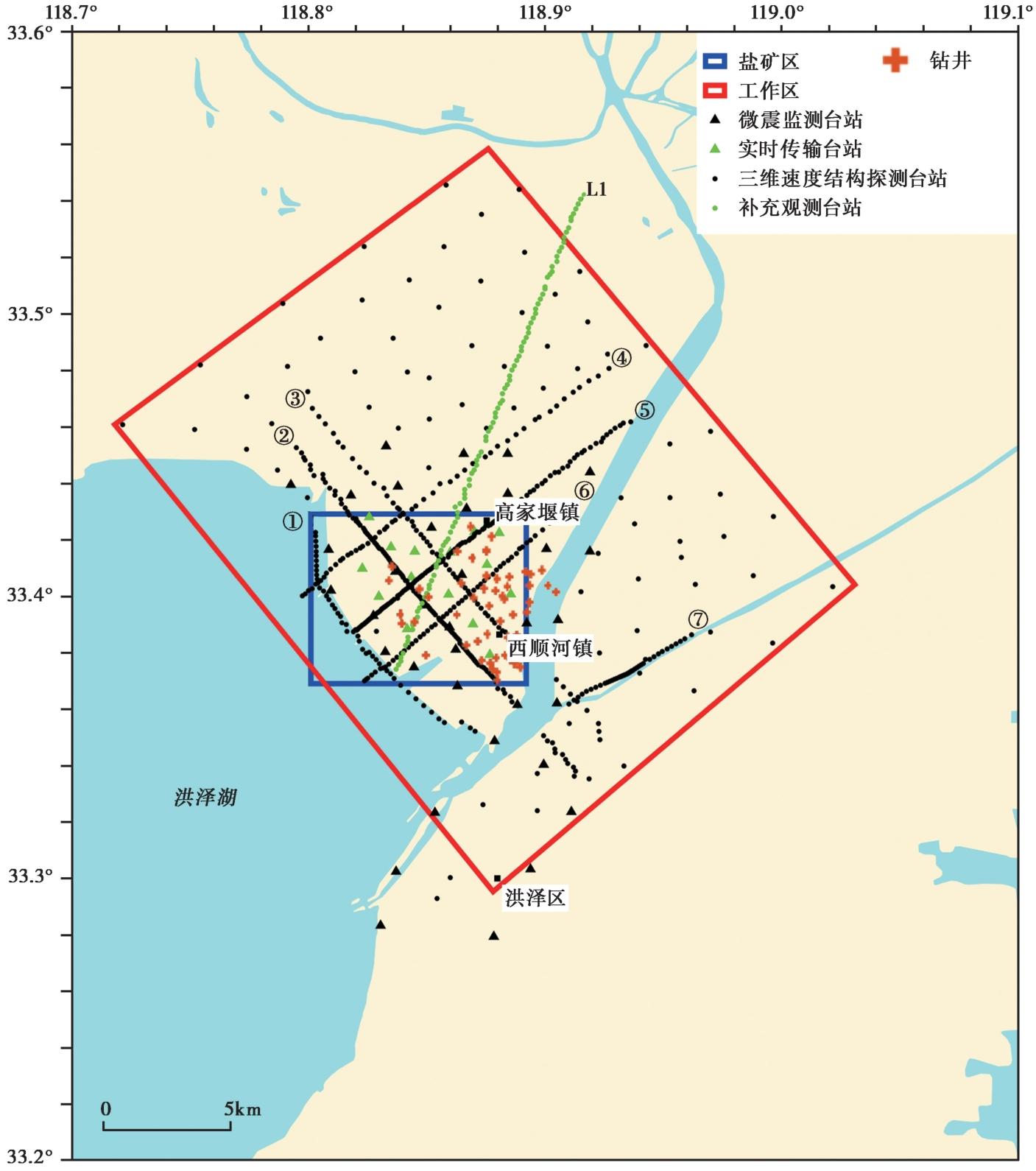
Fig. 3 Location of seismic monitoring stations and drilling sites.
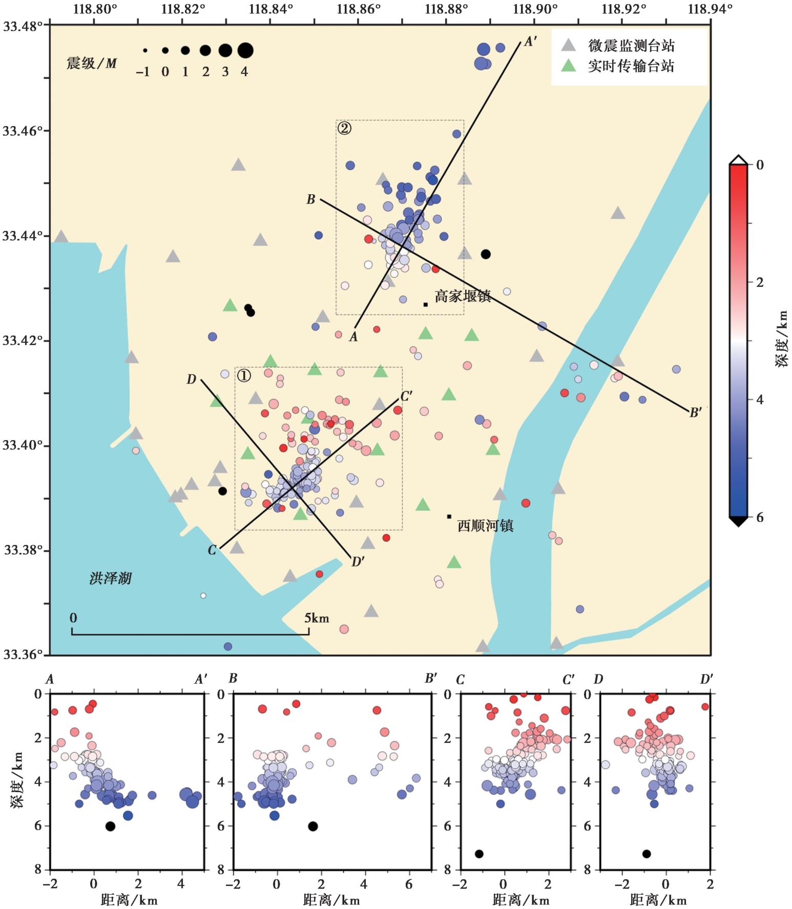
Fig. 4 Spatial distribution of relocated micro-earthquakes.
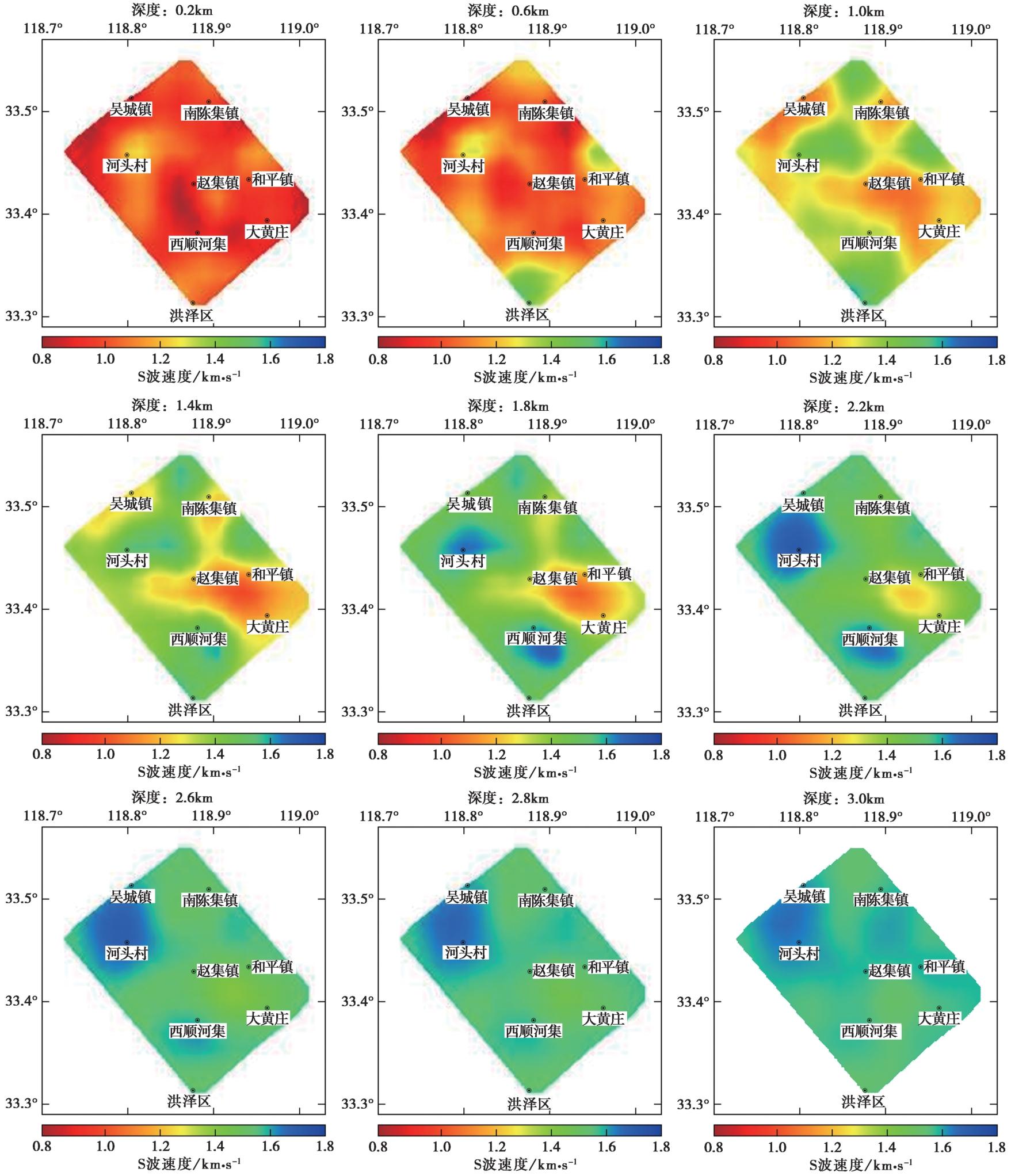
Fig. 5 S-wave velocity distribution at different depths.
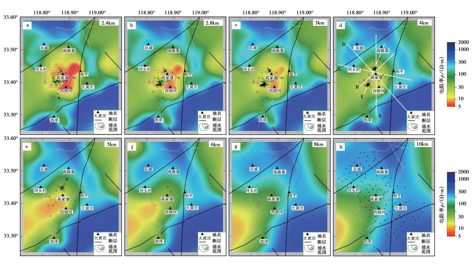
Fig.6 Inversion results of the 3D array( HAX) results for the micro-seismic zone.
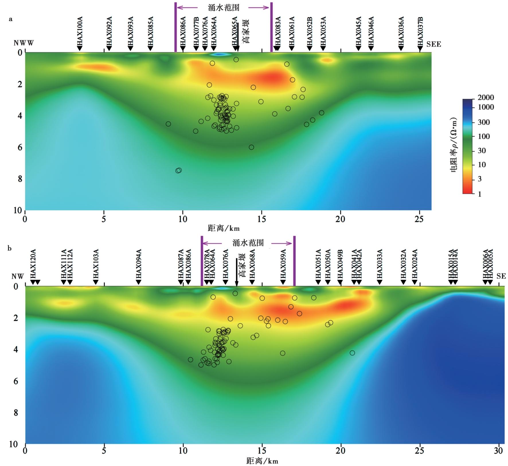
Fig. 7 Cross-sectional view of the 3D array(HAX)results in the micro-seismic zone.
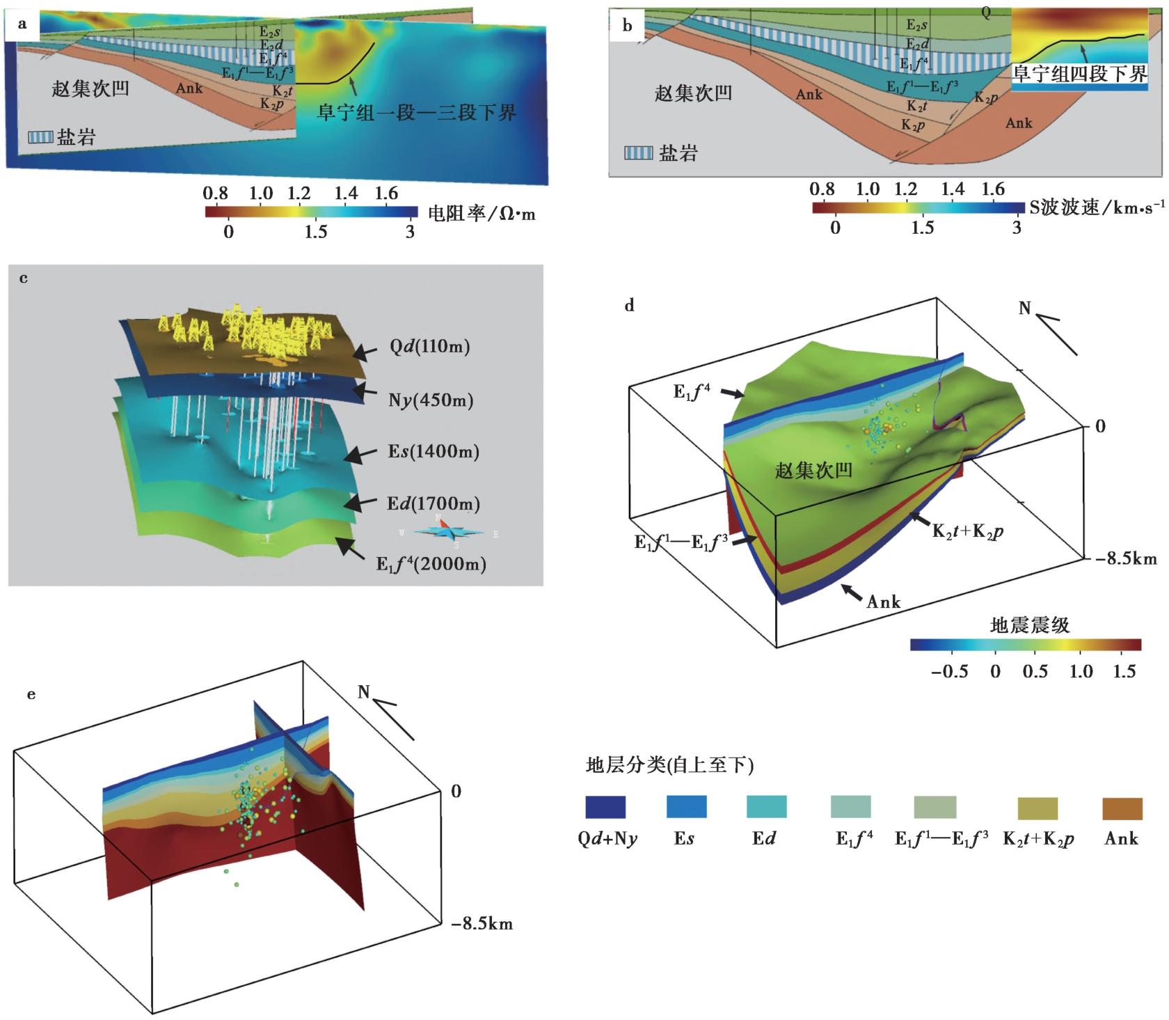
Fig. 8 Geophysical interpretation of stratigraphy and 3D structural model construction.
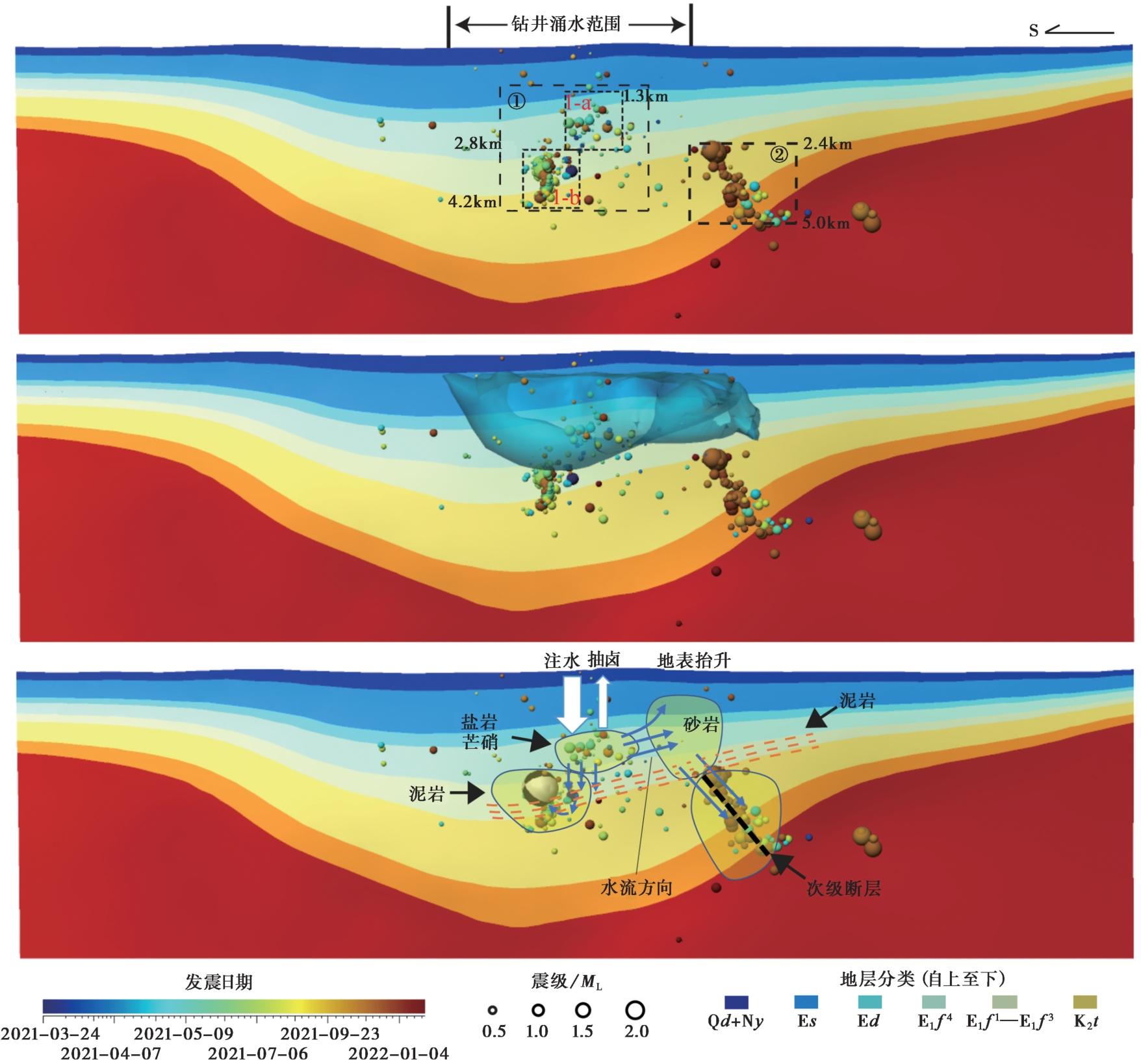
Fig. 9 Distribution of micro-earthquakes and water inrush zone, and schematic pattern of induced seismicity and surface deformation in the mining area cross-section.
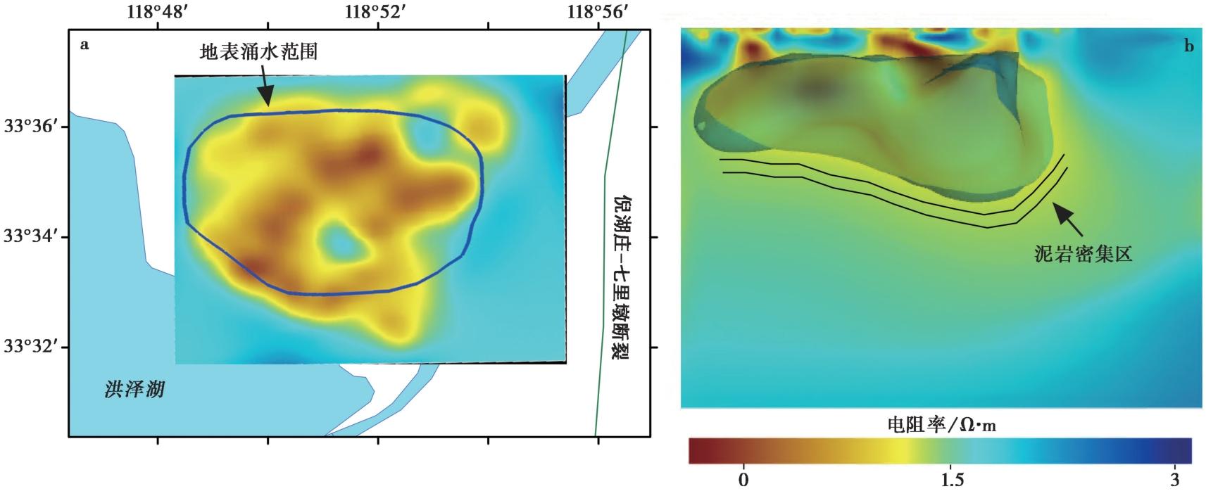
Fig. 10 Distribution of 3D water inrush zones and mudstone.
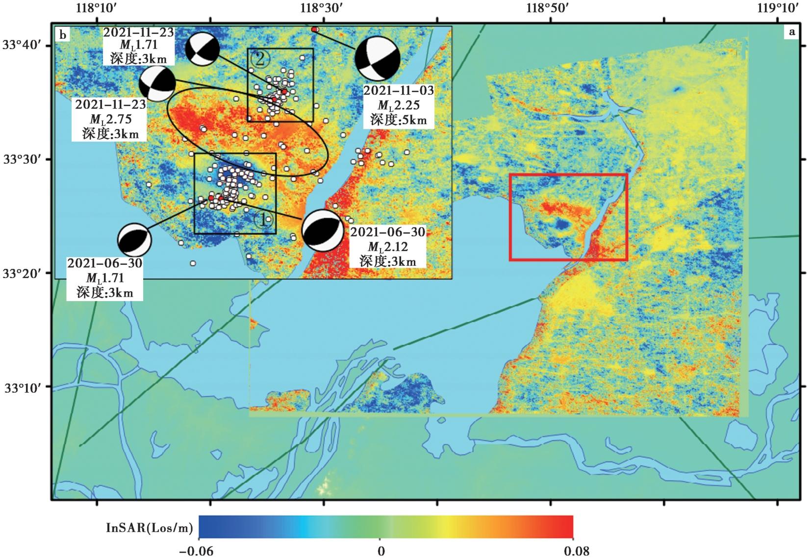
Fig. 11 Regional InSAR deformation field and aftershock focal mechanisms.
| [1] |
陈安定. 2010. 苏北盆地构造特征及箕状断陷形成机理[J]. 石油与天然气地质, 31(2): 140-150.
|
|
|
|
| [2] |
陈友飞, 严钦尚, 许世远. 1993. 苏北盆地沉积环境演变及其构造背景[J]. 地质科学, 28(2): 151-160.
|
|
|
|
| [3] |
傅强, 纪友亮, 刘玉瑞, 等. 2007. 苏北盆地高邮凹陷古近系阜宁组储层动力学特征[J]. 天然气工业, 27(7): 31-34.
|
|
|
|
| [4] |
李小明, 姜芹芹, 朱卫琴, 等. 2018. 洪泽凹陷赵集矿区盐矿分布特征及矿层对比分析[J]. 中国井矿盐, 49(5): 16-19.
|
|
|
|
| [5] |
刘巧霞, 田晓峰, 王清东, 等. 2026. 江苏淮安盐矿区地震活动智能监测及其分布特征[J]. 地球科学, 51(1): 160-172.
|
|
|
|
| [6] |
刘寅, 陈清华, 胡凯, 等. 2014. 渤海湾盆地与苏北-南黄海盆地构造特征和成因对比[J]. 大地构造与成矿学, 38(1): 38-51.
|
|
|
|
| [7] |
刘钟尹, 陈小斌, 蔡军涛, 等. 2022. 大地电磁三维反演云计算系统toPeak的设计与实现[J]. 地震地质, 44(3): 802-820.
DOI |
|
DOI |
|
| [8] |
毛凤鸣, 陈安定, 严元锋, 等. 2006. 苏北盆地复杂小断块油气成藏特征及地震识别技术[J]. 石油与天然气地质, 27(6): 827-840.
|
|
|
|
| [9] |
孟亚锋, 姚华健, 王行舟, 等. 2019. 基于背景噪声成像方法研究郯庐断裂带中南段及邻区地壳速度结构与变形特征[J]. 地球物理学报, 62(7): 2490-2509.
DOI |
|
|
|
| [10] |
舒福明. 2004. 洪泽凹陷赵集次凹阜宁组四段盐岩沉积特征及成因[J]. 安徽地质, 14(2): 81-85.
|
|
|
|
| [11] |
宋尚武, 王庆良, 张佩, 等. 2018. 郯庐断裂带南段及其周边地区应力场分区与反演[J]. 地震研究, 41(3): 457-463.
|
|
|
|
| [12] |
王椿镛, 段永红, 吴庆举, 等. 2016. 华北强烈地震深部构造环境的探测与研究[J]. 地震学报, 38(4): 511-549.
|
|
|
|
| [13] |
王金艳, 鲁人齐, 张浩, 等. 2020. 郯庐断裂带江苏段新生界三维地质构造建模[J]. 地震学报, 42(2): 216-230.
|
|
|
|
| [14] |
王岩生, 胡新兆. 2019. 淮安赵集岩盐矿井涌水分析及治理[J]. 地质学刊, 43(4): 690-695.
|
|
DOI URL |
|
| [15] |
杨云, 于悦颖, 许田. 2022. 淮安地区小震精定位研究[J]. 地震地磁观测与研究, 43(S1): 400-402.
|
|
|
|
| [16] |
张美, 2014. 洪泽凹陷赵集次凹阜宁组四段盐岩成因及分布规律研究[D]. 青岛: 中国石油大学(华东): 1-93.
|
|
|
|
| [17] |
|
| [18] |
|
| [19] |
DOI PMID |
| [20] |
DOI URL |
| [21] |
DOI URL |
| [22] |
DOI URL |
| [23] |
DOI URL |
| [24] |
PMID |
| [25] |
DOI URL |
| [26] |
DOI URL |
| [27] |
|
| [28] |
|
| [1] | CHEN Qian, ZHANG Zhu-qi. CRUSTAL DEFORMATION CHARACTERISTICS AND RELEVANT SEISMIC HAZARD OF THE TAIYUAN BASIN [J]. SEISMOLOGY AND GEOLOGY, 2025, 47(1): 189-213. |
| [2] | ZHANG Yan, JI Zhi-wei, ZHAI Hong-yu, WU Chun-hao. GROUND MOTION SIMULATION CONSIDERING VELOCITY DISPERSION AND ITS IMPLICATIONS FOR SEISMIC HAZARD ASSESSMENT [J]. SEISMOLOGY AND GEOLOGY, 2024, 46(6): 1408-1425. |
| [3] | SUN Xiao, LU Ren-qi, ZHANG Jin-yu, WANG Wei, SU Peng. A NEW REFERENCE SCHEME FOR THE DELINEATION OF ACTIVE BLOCK BOUNDARIES IN THE SICHUAN-YUNNAN EXPERIMENTAL SITE [J]. SEISMOLOGY AND GEOLOGY, 2024, 46(5): 1027-1047. |
| [4] | CHEN Bai-xu, YU Zhong-yuan, XIAO Peng, DAI Xun-ye, ZHANG Shi-long, ZHENG Rong-ying. THE NEW FINDINGS OF SURFACE RUPTURE ZONES AND ITS SEISMOLOGICAL SIGNIFICANCE OF THE EASTERN MARGIN OF YUMUSHAN FAULT, NORTHEASTERN MARGIN OF QINGZANG PLATEAU [J]. SEISMOLOGY AND GEOLOGY, 2024, 46(3): 589-607. |
| [5] | XU Jing, JI Ling-yun, LIU Chuan-jin. REGIONAL DEFORMATION BACKGROUND AND COSEISMIC DEFORMATION CHARACTERISTICS OF THE 2022 LUDING MS6.8 EARTHQUAKE [J]. SEISMOLOGY AND GEOLOGY, 2024, 46(3): 645-664. |
| [6] | LI Hao-feng, XU Yue-ren, GUO Ya-li, LIU Han, ZHAO Xin-yu, LU Ling-yu, TANG Jia-cheng. REMOTE SENSING INTEPRETATION OF COSEISMIC LAND-SLIDES TRIGGERED BY 1976 LONGLING MS7.3 AND MS7.4 EARTHQUAKES AND THE TECTONIC SIGNIFICANCES [J]. SEISMOLOGY AND GEOLOGY, 2024, 46(1): 117-140. |
| [7] | CHEN Kun, GAO Meng-tan, YU Yan-xiang, XU Wei-jin, DU Yi, LI Xue-jin, LU Dong-hua. PROBABILISTIC SEISMIC HAZARD ANALYSIS ALGORITHM INTEGRATING THREE-DIMENSIONAL FAULT SOURCES AND POTENTIAL SEISMIC SOURCE ZONE USING RANDOM SAMPLING [J]. SEISMOLOGY AND GEOLOGY, 2023, 45(2): 435-454. |
| [8] | WANG Shao-jun, LIU Yun-hua, SHAN Xin-jian, QU Chun-yan, ZHANG Guo-hong, XIE Zhao-di, ZHAO De-zheng, FAN Xiao-ran, HUA Jun, LIANG Shi-ming, ZHANG Ke-liang, DAI Cheng-long. COSEISMIC SURFACE DEFORMATION AND SLIP MODELS OF THE 2021 MS6.4 YANGBI(YUNNAN, CHINA)EARTHQUAKE [J]. SEISMOLOGY AND GEOLOGY, 2021, 43(3): 692-705. |
| [9] | HUA Jun, ZHAO De-zheng, SHAN Xin-jian, QU Chun-yan, ZHANG Ying-feng, GONG Wen-yu, WANG Zhen-jie, LI Cheng-long, LI Yan-chuan, ZHAO Lei, CHEN Han, FAN Xiao-ran, WANG Shao-jun. COSEISMIC DEFORMATION FIELD, SLIP DISTRIBUTION AND COULOMB STRESS DISTURBANCE OF THE 2021 MW7.3 MADUO EARTHQUAKE USING SENTINEL-1 INSAR OBSERVATIONS [J]. SEISMOLOGY AND GEOLOGY, 2021, 43(3): 677-691. |
| [10] | YU Zhong-yuan, PAN Hua, SHEN Jun, LI Jin-chen, ZHANG Meng, DAI Xun-ye. THE ACTIVITY FEATURES OF XIADIAN FAULT ZONE REVEALED BY RONGJIABAO TRENCH AND ITS PROBABILISTIC SEISMIC HAZARD EVALUATION [J]. SEISMOLOGY AND GEOLOGY, 2020, 42(3): 688-702. |
| [11] | LI Yu-jiang, SHI Fu-qiang, ZHANG Hui, WEI Wen-xin, XU Jing, SHAO Zhi-gang. COULOMB STRESS CHANGE ON ACTIVE FAULTS IN SICHUAN-YUNNAN REGION AND ITS IMPLICATIONS FOR SEISMIC HAZARD [J]. SEISMOLOGY AND GEOLOGY, 2020, 42(2): 526-546. |
| [12] | MAO Ze-bin, CHANG Zu-feng, LI Jian-lin, CHANG Hao, ZHAO Jin-min, CHEN Gang. LATE QUATERNARY ACTIVITY OF FAULTS IN THE EPICENTER AREA OF JINGGU M6.6 EARTHQUAKE [J]. SEISMOLOGY AND GEOLOGY, 2019, 41(4): 821-836. |
| [13] | CHEN Zhao-hui, MENG Xiao-hong, ZHANG Shuang-xi, LIU Jin-zhao, WANG Tong-qing, ZHANG Pin, WEI Shao-gang. CHARACTERISTICS OF MULTI-SCALE GRAVITY FIELD VARIATION AND SEISMOGENIC MECHANISM ANALYSIS IN THE SOUTHEASTERN TIBETAN PLATEAU [J]. SEISMOLOGY AND GEOLOGY, 2019, 41(3): 690-703. |
| [14] | DONG Shao-peng, ZHANG Pei-zhen, ZHENG Wen-jun, YU Zhong-yuan, LEI Qi-yun, YANG Hui-li, LIU Jin-feng, GONG Hui-ling. PALEOSEISMOLOGICAL RESEARCH ON THE LANGSHAN RANGE-FRONT FAULT, HETAO AREA, CHINA: INSIGHTS FOR STUDIES ON TECTONICS AND SEISMIC RISK [J]. SEISMOLOGY AND GEOLOGY, 2018, 40(6): 1216-1239. |
| [15] | XU Jing, JI Ling-yun, JI Cun-wei, SUN He, ZHAO Qiang. COULOMB STRESS EVOLUTION AND SEISMIC HAZARD ALONG THE EASTERN BOUNDARY OF THE SICHUAN-YUNNAN BLOCK [J]. SEISMOLOGY AND GEOLOGY, 2017, 39(3): 451-469. |
| Viewed | ||||||
|
Full text |
|
|||||
|
Abstract |
|
|||||
Copyright © SEISMOLOGY AND GEOLOGY, All Rights Reserved.
Tel: 010-62009049/9063 E-mail: dzdz@ies.ac.cn
Powered by Beijing Magtech Co., Ltd.