
SEISMOLOGY AND GEOLOGY ›› 2026, Vol. 48 ›› Issue (4): 1158-1175.DOI: 10.3969/j.issn.0253-4967.20250055
• Academic Debate • Previous Articles Next Articles
REVISION OF THE BOUNDARIES OF THE SEISMIC ZONE IN NORTHEASTERN CHINA
BAO Ren-kai1,2)( ), ZHOU Qing1),*(), WU Guo1)
- 1)
Institute of Geology ,China Earthquake Administration, Division of Active Tectonics and Seismic Hazard
2)Earthquake Administration of Inner Mongolia Autonomous Region ,Xilinhot Earthquake Monitoring Center Station
-
Received:2025-02-21Revised:2025-06-02Online:2026-08-20Published:2026-09-09
东北地震区的边界修订
包任锴1,2)(), 周庆1),*(), 吴果1)
- 1)
中国地震局地质研究所 ,强震构造与地震危险性研究室
2)内蒙古自治区地震局
-
通讯作者:* 周庆, 男, 1963年生, 博士, 研究员, 现主要研究方向为地震活动性分析、 地震危险性分析与地震地质灾害评价, E-mail: zqcsb@163.com。 -
作者简介:包任锴, 男, 1995年生, 助理工程师, 现为中国地震局地质研究所构造地质专业在读硕士研究生, 主要从事工程地震与地震区划研究, E-mail: nmgbrk@163.com。
-
基金资助:国家重点研发计划项目(2022YFC3003502)

Cite this article
BAO Ren-kai, ZHOU Qing, WU Guo. REVISION OF THE BOUNDARIES OF THE SEISMIC ZONE IN NORTHEASTERN CHINA[J]. SEISMOLOGY AND GEOLOGY, 2026, 48(4): 1158-1175.
包任锴, 周庆, 吴果. 东北地震区的边界修订[J]. 地震地质, 2026, 48(4): 1158-1175.
share this article
Add to citation manager EndNote|Ris|BibTeX
URL: https://www.dzdz.ac.cn/EN/10.3969/j.issn.0253-4967.20250055
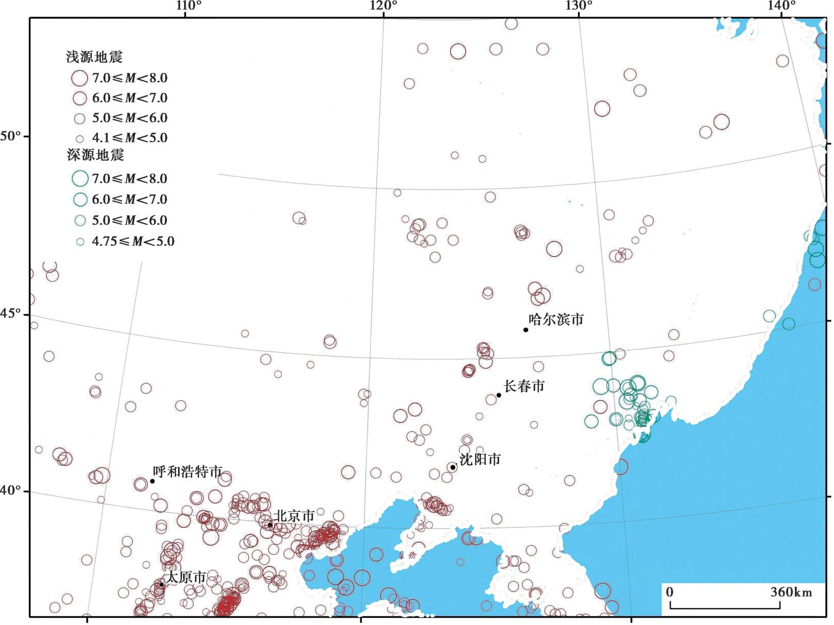
Fig. 1 Distribution map of earthquakes in northeastern China and adjacent regions.
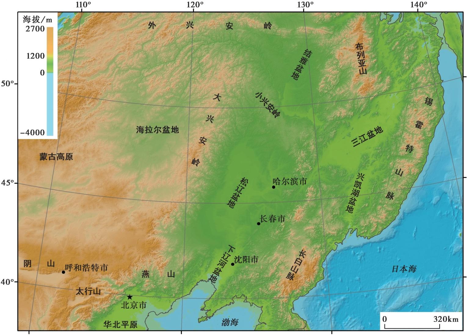
Fig. 2 Topographic and geomorphologic map of northeastern China and adjacent regions.
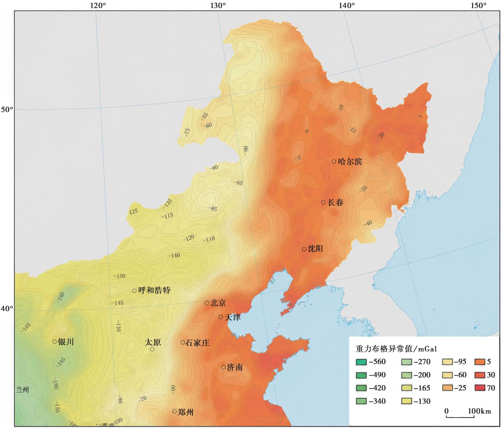
Fig. 3 Map of Bouguer gravity anomaly in northeastern China.
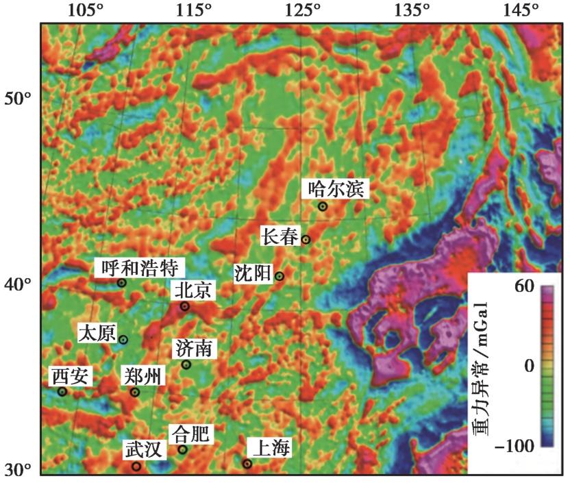
Fig. 4 Map of residual gravity anomaly in eastern China and adjacent regions.
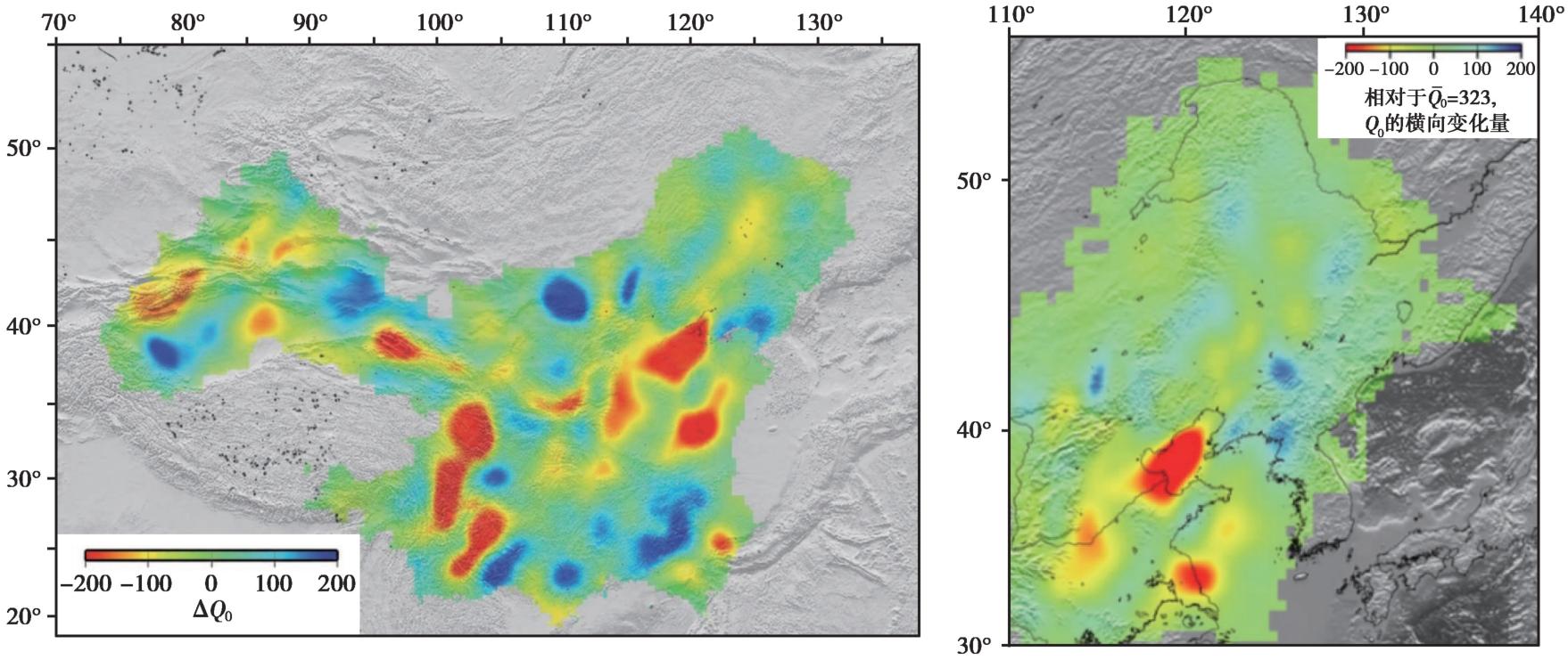
Fig. 5 Lateral variation of Q0.
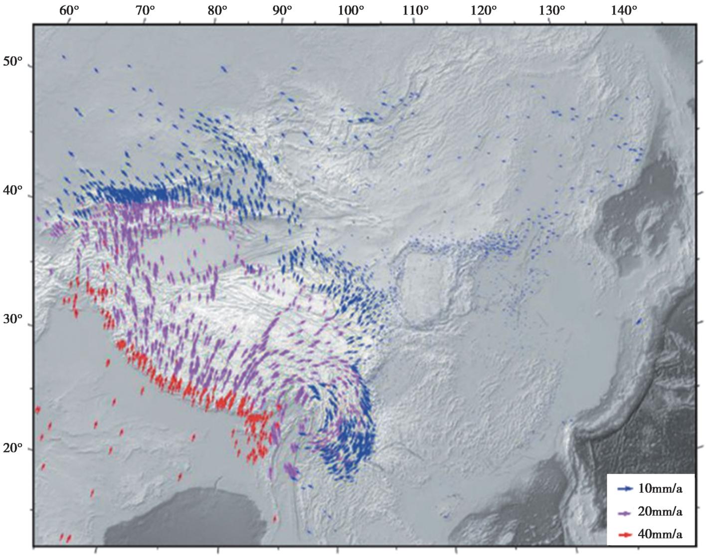
Fig. 6 GNSS evidences.
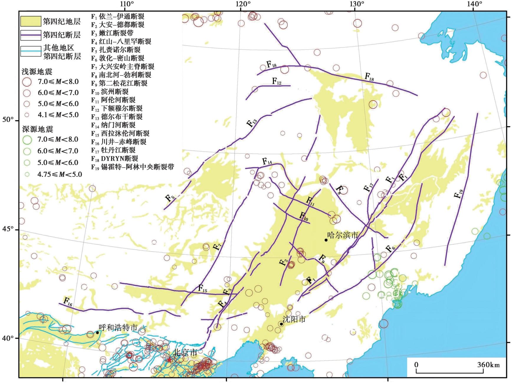
Fig. 7 Distribution map of earthquakes and major faults in northeastern China and adjacent regions.
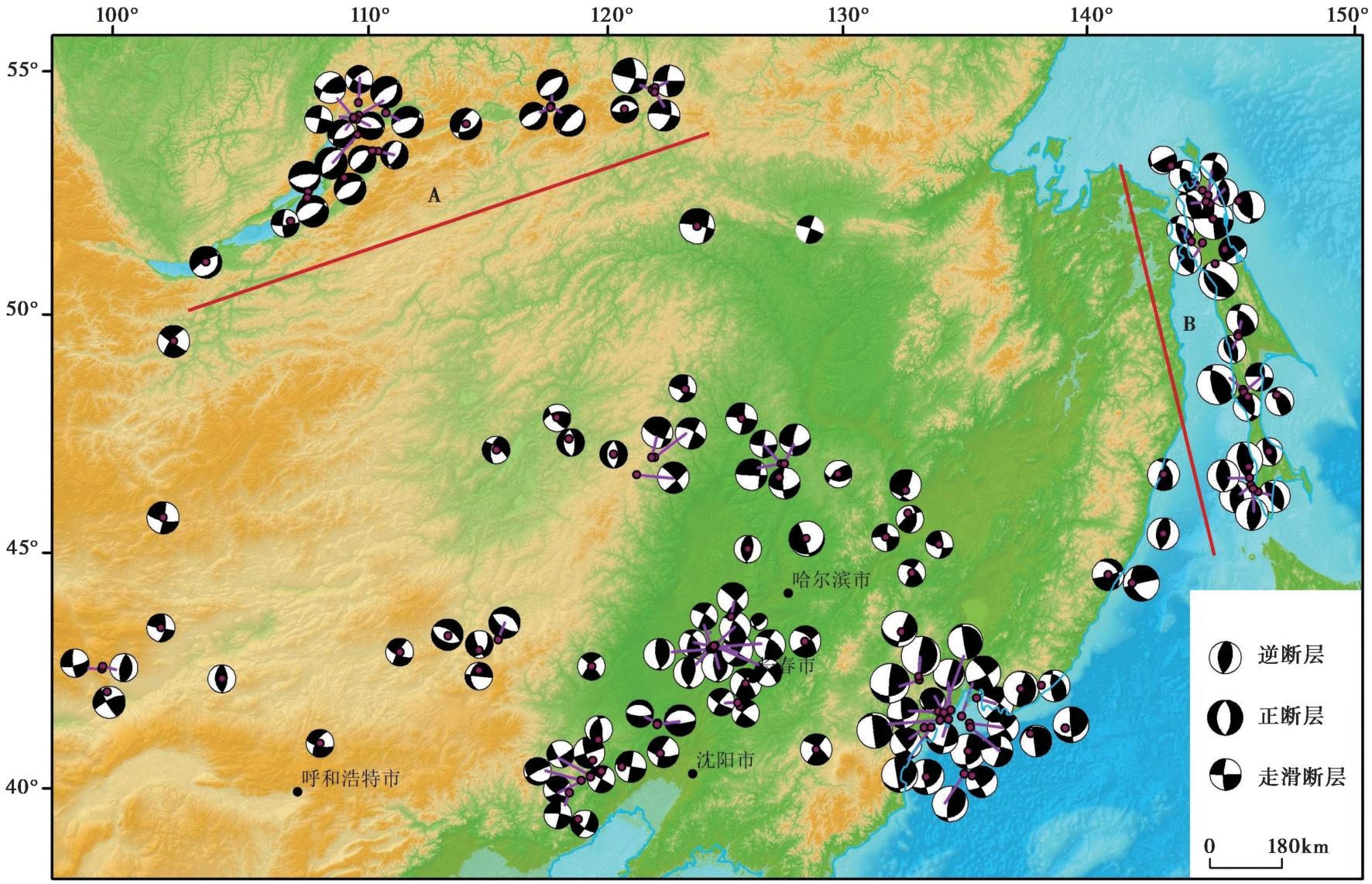
Fig. 8 Distribution map of focal mechanism solutions in northeastern China and adjacent regions.
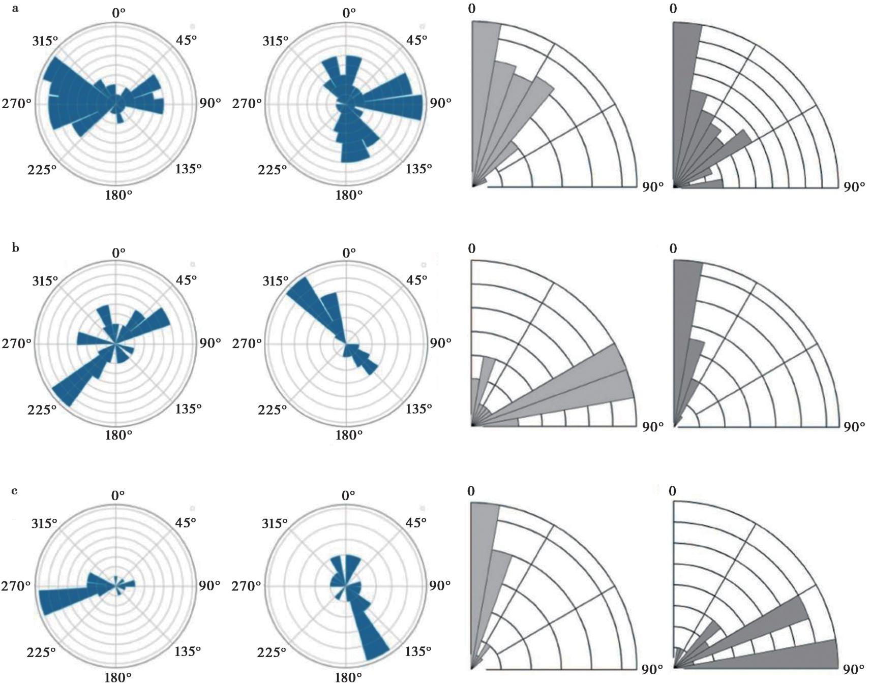
Fig. 9 Distribution of P-and T-axis azimuths and dip angles.
| 区域 | 主压应力方向 | 主张应力方向 | 断层类型 | 应力环境 |
|---|---|---|---|---|
| 外兴安岭地区 | NE-SW(近垂直) | NW-SE(近水平) | 正断层为主 | 伸展环境 |
| 库页岛地区 | 近EW(近水平) | SSE(近垂直) | 逆断层为主 | 挤压环境显著 |
| 中国东北及邻区 | 近EW或(低角度) | 近SN局部EW(低角度) | 走滑、走滑兼逆断层为主 | 挤压主导 |
Table1 Comparison of tectonic stress fields in the Outer Xing'an mountains, Sakhalin island, northeast China, and adjacent areas
| 区域 | 主压应力方向 | 主张应力方向 | 断层类型 | 应力环境 |
|---|---|---|---|---|
| 外兴安岭地区 | NE-SW(近垂直) | NW-SE(近水平) | 正断层为主 | 伸展环境 |
| 库页岛地区 | 近EW(近水平) | SSE(近垂直) | 逆断层为主 | 挤压环境显著 |
| 中国东北及邻区 | 近EW或(低角度) | 近SN局部EW(低角度) | 走滑、走滑兼逆断层为主 | 挤压主导 |
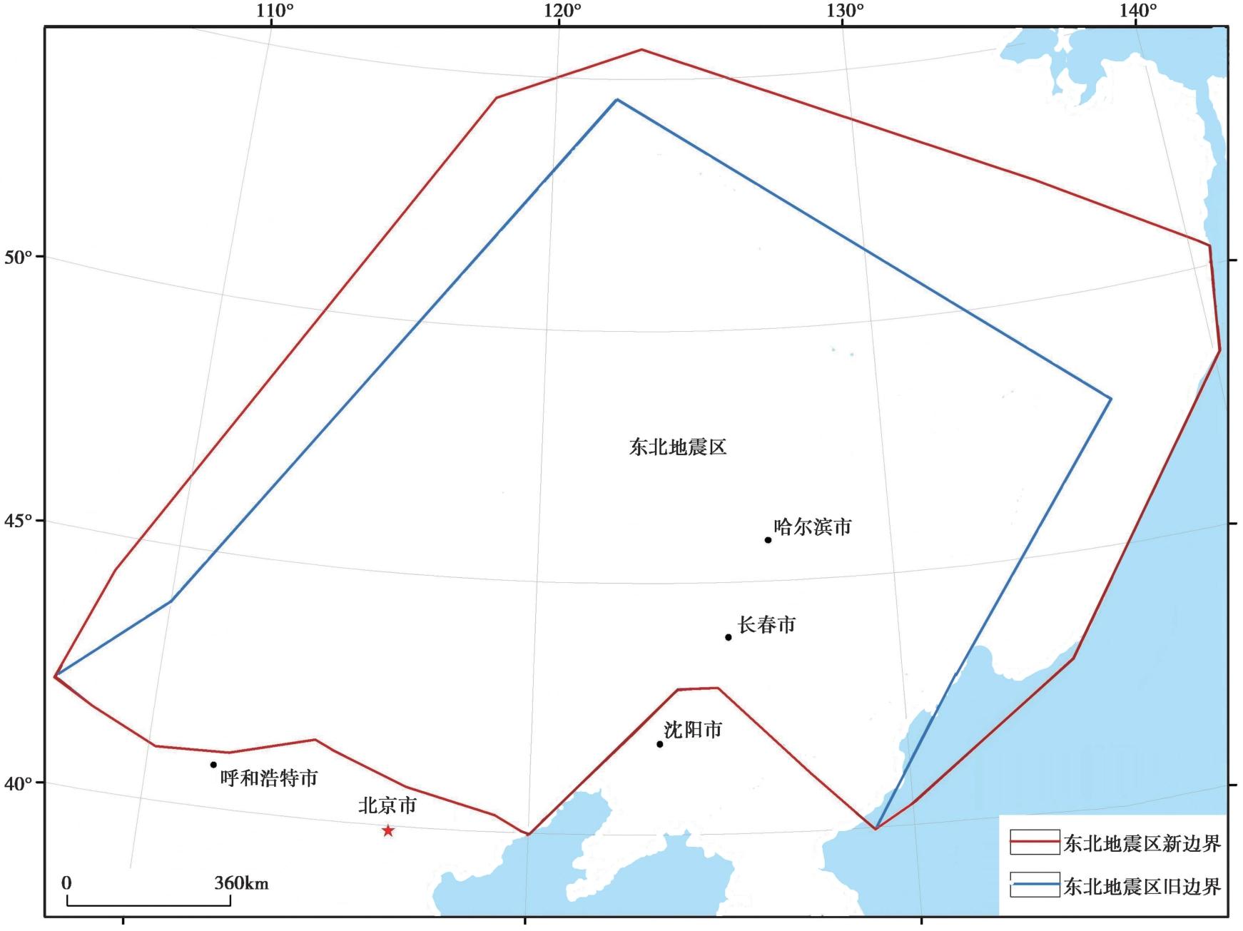
Fig. 10 Comparison map of old and new boundary delineations of the seismic zone in northeastern China.
| [1] |
包汉勇, 郭战峰, 张罗磊, 等. 2013. 太平洋板块形成以来的中国东部构造动力学背景[J]. 地球科学进展, 28(3): 337-338.
DOI |
|
|
|
| [2] |
陈永明, 石玉成. 2007. 兰州地区现代应力场的构造解析[J]. 西北地震学报, 29(1): 84-87.
|
|
|
|
| [3] |
方署, 张忠, 于海洋, 等. 2013. 内蒙古东部大地构造[M]. 北京: 地质出版社: 361-362.
|
|
|
|
| [4] |
冯兵, 胡亚轩, 柴旭超, 等. 2024. 基于震源机制分析中国东北地区现今构造动力学背景[J]. 地震科学进展, 54(4): 258-264.
|
|
|
|
| [5] |
傅维洲. 1996. 中国东北深震及其构造意义[J]. 长春地质学院学报, 26(3): 77-82.
|
|
|
|
| [6] |
高立新, 戴勇. 2020. 现今中国东北地区地球动力学环境[J]. 大地测量与地球动力学, 40(11): 1101-1107.
|
|
|
|
| [7] |
高孟潭. 2015. 《中国地震动参数区划图》宣贯教材(GB18306-2015)[M]. 北京: 中国标准出版社.
|
|
|
|
| [8] |
葛肖虹, 刘俊来, 任收麦, 等. 2014. 中国东部中-新生代大陆构造的形成与演化[J]. 中国地质, 41(1): 19-38.
|
|
|
|
| [9] |
郭祥云, 蒋长胜, 韩立波, 等. 2022. 中国大陆及邻区震源机制数据集(2009-2021年)[DB/OL]. 国家地震科学数据中心, 2022[2025-02-11]. https://data.earthquake.cn. doi:10.12080/nedc.11.ds.2022.0004.
|
|
|
|
| [10] |
郝明, 王庆良. 2020. GNSS空间大地测量技术在中国大陆活动地块划分中的应用和研究进展[J]. 地震地质, 42(2): 283-296. doi: 10.3969/j.issn.0253-4967.2020.02.003.
|
|
DOI |
|
| [11] |
黄汲清, 任纪舜, 姜春发, 等. 1980. 中国大地构造及其演化(1︰400万中国大地构造图简要说明)[M]. 北京: 科学出版社: 1-124.
|
|
|
|
| [12] |
黄宗理, 王典, 严加永, 等. 2016. 欧亚大陆东缘存在一个巨型深断裂系统: 基于卫星重力的新发现[J]. 地球学报, 37(1): 25-34.
|
|
|
|
| [13] |
江为为, 周立宏, 肖敦清, 等. 2006. 东北地区重磁场与地壳结构特征[J]. 地球物理学进展, 21(3): 730-738.
|
|
|
|
| [14] |
李恩泽, 刘财, 张良怀, 等. 2012. 松辽盆地地震构造与地震活动相关性研究[J]. 地球物理学进展, 27(4): 1337-1349.
|
|
|
|
| [15] |
李洪丽. 2021. 中国东北、 华北地区地壳结构不均匀性与强震孕震机制研究[D]. 长春: 吉林大学.
|
|
|
|
| [16] |
李锦轶. 2009. 中国大陆地质历史的旋回与阶段[J]. 中国地质, 36(3): 504-527.
|
|
|
|
| [17] |
李锦轶, 刘建峰, 曲军峰, 等. 2019. 中国东北地区主要地质特征和地壳构造格架[J]. 岩石学报, 35(10): 2989-3016.
|
|
DOI URL |
|
| [18] |
李双林, 欧阳自远. 1998. 兴蒙造山带及邻区的构造格局与构造演化[J]. 海洋地质与第四纪地质, 18(3): 45-54.
|
|
|
|
| [19] |
刘恺, 张进江, 葛茂卉, 等. 2016. 中生代兴蒙造山带东缘的古太平洋板块俯冲[J]. 矿物岩石地球化学通报, 35(6): 1098-1108.
|
|
|
|
| [20] |
闵伟, 焦德成, 周本刚, 等. 2011. 依兰-伊通断裂全新世活动的新发现及其意义[J]. 地震地质, 33(1): 141-150. doi: 10.3969/j.issn.0253-4967.2011.01.014.
|
|
DOI |
|
| [21] |
内蒙古自治区地质矿产局. 1996. 内蒙古自治区岩石地层[M]. 武汉: 中国地质大学出版社: 1-344.
|
|
Geological and Mineral Resources Bureau of Inner Mongolia Autonomous Region. 1996. Lithostratigraphy of Inner Mongolia Autonomous Region[M]. China University of Geosciences Press, Wuhan: 1-344 (in Chinese).
|
|
| [22] |
宁杰远, 臧绍先. 1987. 日本海及中国东北地震的深度分布及其应力状态[J]. 地震地质, 9(2): 49-61.
|
|
|
|
| [23] |
任纪舜. 1991. 论中国大陆岩石圈构造的基本特征[J]. 中国区域地质, (4): 289-293.
|
|
|
|
| [24] |
孙莲, 李永华, 吴庆举, 等. 2012. 中国东北及周边地区地壳横波衰减的成像研究[J]. 地球物理学报, 55(4): 1179-1185.
|
|
|
|
| [25] |
孙文斌, 王晓峰, 常征, 等. 2005. 我国东北地区地震时空演变特征及其动力学研究[J]. 东北地震研究, 21(2): 1-8.
|
|
|
|
| [26] |
涂广红, 江为为, 朱东英, 等. 2006. 中国东北地区剩余重磁异常特征与地质构造及成矿带的关系[J]. 地球物理学进展, 21(3): 746-755.
|
|
|
|
| [27] |
万天丰, 赵庆乐. 2012. 中国东部构造-岩浆作用的成因[J]. 中国科学(地球科学), 42(2): 155-163.
|
|
|
|
| [28] |
王鸿祯. 1981. 从活动论观点论中国大地构造分区[J]. 地球科学, (1): 42-66.
|
|
|
|
| [29] |
汪素云, 裴顺平,
|
|
|
|
| [30] |
王璞珺, 赵然磊, 蒙启安, 等. 2015. 白垩纪松辽盆地: 从火山裂谷到陆内拗陷的动力学环境[J]. 地学前缘, 22(3): 99-117.
DOI |
|
DOI |
|
| [31] |
王五力, 李永飞, 郭胜哲. 2014. 中国东北地块群及其构造演化[J]. 地质与资源, 23(1): 4-24.
|
|
|
|
| [32] |
谢富仁, 崔效锋, 赵建涛, 等. 2004. 中国大陆及邻区现代构造应力场分区[J]. 地球物理学报, 47(4): 654-662.
|
|
|
|
| [33] |
许文良, 孙晨阳, 唐杰, 等. 2019. 兴蒙造山带的基底属性与构造演化过程[J]. 地球科学, 44(5): 1620-1646.
|
|
|
|
| [34] |
许忠淮. 2001. 东亚地区现今构造应力图的编制[J]. 地震学报, 23(5): 492-501.
|
|
|
|
| [35] |
张凤鸣, 张亚江, 许晓艳, 等. 2007. 日本海西部-中国东北深震区俯冲运动对东北地区浅源地震的动力作用[J]. 东北地震研究, 23(1): 33-39.
|
|
|
|
| [36] |
张立敏, 唐晓明. 1983. 西太平洋板块俯冲运动与中国东北深震带[J]. 地球物理学报, 26(4): 331-340.
|
|
|
|
| [37] |
张培震, 邓起东, 张国民, 等. 2003. 中国大陆的强震活动与活动地块[J]. 中国科学(D辑), 33(S1): 12-20.
|
|
|
|
| [38] |
张培震, 王琪, 马宗晋. 2002. 中国大陆现今构造运动的GPS速度场与活动地块[J]. 地学前缘, 9(2): 430-441.
|
|
|
|
| [39] |
赵盼, 徐备, 陈岩. 2023. 蒙古-鄂霍茨克洋: 演化过程和最终闭合[J]. 中国科学(地球科学), 53(11): 2541-2559.
|
|
|
|
| [40] |
中国地震局. 2005. 《工程场地地震安全性评价》宣贯教材(GB17741-2005)[M]. 北京: 中国标准出版社.
|
|
China Earthquake Administration. 2005. Seismic Safety Evaluation for Engineering Sites(GB17741-2005)[M]. China Standards Press, Beijing (in Chinese).
|
|
| [41] |
|
| [42] |
DOI URL |
| [43] |
DOI URL |
| [44] |
DOI URL |
| [45] |
|
| [46] |
DOI URL |
| [1] | GAO Shu-de, WU Xiao-ping, LUO Wei-bin, YANG Xiao-peng, WANG Wen-cai, YAO Sai-sai, CHEN Shuang-gui, LIU Jun. SUMMARY OF PRECURSORS OF THE MENYUAN MS6.9 EARTHQUAKE AND ITS INSPIRATION FOR SUB-INSTABILITY THEORY [J]. SEISMOLOGY AND GEOLOGY, 2025, 47(6): 1546-1565. |
| [2] | YAN Yun-peng, XU Jian-dong, DONG Rui-shu. TECTONIC BACKGROUND AND SPATIAL CORRELATION FRACTAL DIMENSION OF STRONG EARTHQUAKES IN TAIWAN, CHINA [J]. SEISMOLOGY AND GEOLOGY, 2004, 26(1): 15-23. |
| [3] | Bian Qiantao, Liu Jiaqi, Luo Xiaoquan, Xiao Jule. GEOTECTONIC SETTING, FORMATION AND EVOLUTION OF THE QINGHAI LAKE [J]. SEISMOLOGY AND GEOLOGY, 2000, 22(1): 20-26. |
| Viewed | ||||||
|
Full text |
|
|||||
|
Abstract |
|
|||||
Copyright © SEISMOLOGY AND GEOLOGY, All Rights Reserved.
Tel: 010-62009049/9063 E-mail: dzdz@ies.ac.cn
Powered by Beijing Magtech Co., Ltd.