
SEISMOLOGY AND GEOLOGY ›› 2026, Vol. 48 ›› Issue (4): 1035-1051.DOI: 10.3969/j.issn.0253-4967.20250066
• Research paper • Previous Articles Next Articles
SURFACE DEFORMATION CHARACTERISTICS OF THE 2025 DINGRI MW7.1 EARTHQUAKE DERIVED FROM GF-2 IMAGERY USING OPTICAL IMAGE CORRELATION TECHNIQUE
SU Qiang1)( ), PAN Jia-wei1,2,3),*(), LI Hai-bing1,2,3), LIU Fu-cai1,2), Marie-luce Chevalier1,2,3), YANG Shao-hua1,2,3), WU Kun-gang1,4), JIANG Chen-yi1)
- 1)
Key Laboratory of Continental Dynamics of Ministry of Natural Resources ,Institute of Geology, Chinese Academy of Geological Sciences
2)National Field Observation and Research Station(Jiangsu Donghai) for Continental Deep Hole Crustal Activity
3)State Key Laboratory of Deep Earth and Mineral Exploration
4)Key Laboratory of Active Tectonics and Geological Safety ,Ministry of Natural Resources, Institute of Geomechanics, Chinese Academy of Geological Sciences
-
Received:2025-03-14Revised:2025-04-27Online:2026-08-20Published:2026-09-09
基于GF-2影像相关性匹配的2025年 MW7.1 西藏定日地震地表变形特征
苏强1)(), 潘家伟1,2,3),*(), 李海兵1,2,3), 刘富财1,2), Marie-Luce Chevalier1,2,3), 杨少华1,2,3), 吴坤罡1,4), 江晨轶1)
- 1)
中国地质科学院地质研究所 ,自然资源部大陆动力学重点实验室
2)江苏东海大陆深孔地壳活动国家野外科学观测研究站
3)深地探测与矿产勘查全国重点实验室
4)中国地质科学院地质力学研究所 ,自然资源部活动构造与地质安全重点实验室
-
通讯作者:* 潘家伟, 男, 1983生, 研究员, 主要从事青藏高原活动构造与地震地质研究, E-mail: jiawei-pan@foxmail.com。 -
作者简介:苏强, 男, 2000年生, 现为中国地质科学院地质研究所地质学专业在读硕士研究生, 从事遥感与活动构造相关研究, E-mail: su202309@163.com。
-
基金资助:中国地质调查局项目(DD20240100703); 科技基础资源调查专项(2021FY100101); 国家自然科学基金(42372274); 国家自然科学基金(42325207); 中国地质科学院地质力学所基本科研业务项目(DZLXJK202413)

Cite this article
SU Qiang, PAN Jia-wei, LI Hai-bing, LIU Fu-cai, Marie-luce Chevalier, YANG Shao-hua, WU Kun-gang, JIANG Chen-yi. SURFACE DEFORMATION CHARACTERISTICS OF THE 2025 DINGRI MW7.1 EARTHQUAKE DERIVED FROM GF-2 IMAGERY USING OPTICAL IMAGE CORRELATION TECHNIQUE[J]. SEISMOLOGY AND GEOLOGY, 2026, 48(4): 1035-1051.
苏强, 潘家伟, 李海兵, 刘富财, Marie-Luce Chevalier, 杨少华, 吴坤罡, 江晨轶. 基于GF-2影像相关性匹配的2025年 MW7.1 西藏定日地震地表变形特征[J]. 地震地质, 2026, 48(4): 1035-1051.
share this article
Add to citation manager EndNote|Ris|BibTeX
URL: https://www.dzdz.ac.cn/EN/10.3969/j.issn.0253-4967.20250066
| 北纬 /(°) | 东经 /(°) | 深度 /km | 震级 | 节面Ⅰ/(°) | 节面Ⅱ/(°) | 资料来源 | ||||
|---|---|---|---|---|---|---|---|---|---|---|
| 走向 | 倾角 | 滑动角 | 走向 | 倾角 | 滑动角 | |||||
| 28.50 | 87.45 | 10 | MS6.8(MW7.1) | 181 | 51 | -81 | 348 | 40 | -100 | CENC |
| 28.639 | 87.361 | 10 | MW7.1 | 187 | 49 | -78 | 349 | 42 | -103 | USGS |
| 28.56 | 87.47 | 12 | MW7.1 | 173 | 48 | -92 | 356 | 42 | -88 | GCMT |
| 28.56 | 87.40 | 10 | MW7.1 | 164 | 41 | -102 | 0 | 49 | -79 | GFZ |
| 28.53 | 87.40 | 10 | MW7.0 | 169 | 40 | -94 | 355 | 50 | -87 | GA |
| 28.639 | 87.361 | 14 | MW7.2 | 196 | 44 | -64 | 341 | 51 | -113 | IPGP |
Table1 Focal mechanisms of the Dingri earthquake from different institutions
| 北纬 /(°) | 东经 /(°) | 深度 /km | 震级 | 节面Ⅰ/(°) | 节面Ⅱ/(°) | 资料来源 | ||||
|---|---|---|---|---|---|---|---|---|---|---|
| 走向 | 倾角 | 滑动角 | 走向 | 倾角 | 滑动角 | |||||
| 28.50 | 87.45 | 10 | MS6.8(MW7.1) | 181 | 51 | -81 | 348 | 40 | -100 | CENC |
| 28.639 | 87.361 | 10 | MW7.1 | 187 | 49 | -78 | 349 | 42 | -103 | USGS |
| 28.56 | 87.47 | 12 | MW7.1 | 173 | 48 | -92 | 356 | 42 | -88 | GCMT |
| 28.56 | 87.40 | 10 | MW7.1 | 164 | 41 | -102 | 0 | 49 | -79 | GFZ |
| 28.53 | 87.40 | 10 | MW7.0 | 169 | 40 | -94 | 355 | 50 | -87 | GA |
| 28.639 | 87.361 | 14 | MW7.2 | 196 | 44 | -64 | 341 | 51 | -113 | IPGP |
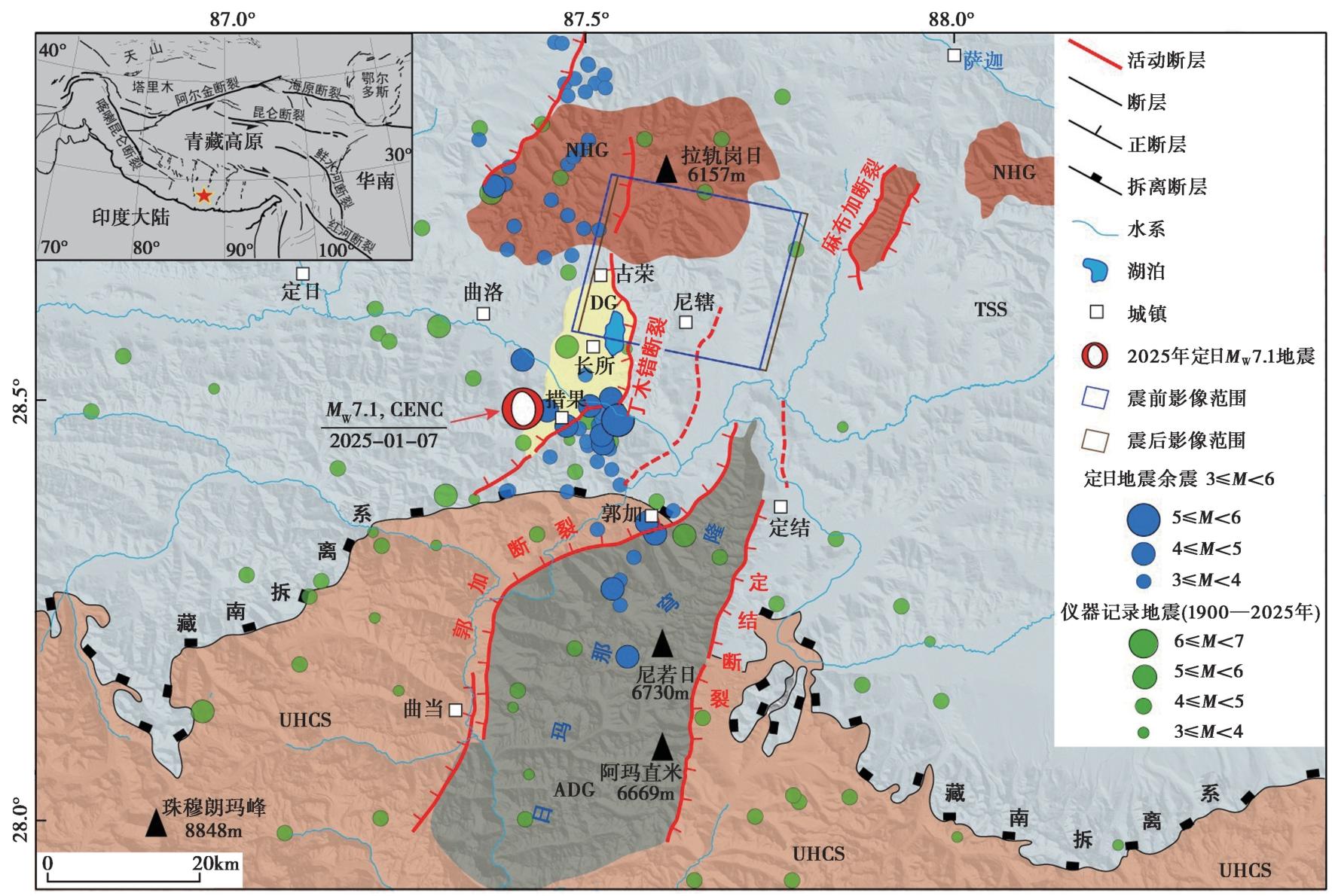
Fig. 1 Geological and tectonic background map of the Dingri earthquake(after Kali, 2010; Leloup et al., 2010).
| 类别 | 采集时间 | 空间分辨率/m | 含云量/% | 侧摆角/(°) | 偏航角/(°) | 俯仰角/(°) |
|---|---|---|---|---|---|---|
| 震前GF-2影像 | 2024-12-24,11:37 | 0.81 | 0 | -0.006688 | 3.311295 | 0.000507 |
| 震后GF-2影像 | 2025-01-08,11:43 | 0.81 | 0 | 9.9193464 | 3.240400 | 0.000420 |
Table2 GF-2 optical image information used in this study
| 类别 | 采集时间 | 空间分辨率/m | 含云量/% | 侧摆角/(°) | 偏航角/(°) | 俯仰角/(°) |
|---|---|---|---|---|---|---|
| 震前GF-2影像 | 2024-12-24,11:37 | 0.81 | 0 | -0.006688 | 3.311295 | 0.000507 |
| 震后GF-2影像 | 2025-01-08,11:43 | 0.81 | 0 | 9.9193464 | 3.240400 | 0.000420 |
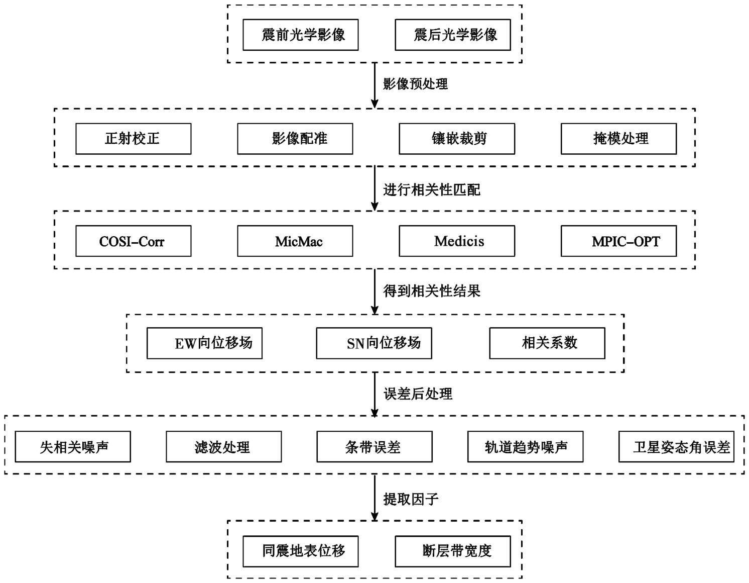
Fig. 2 Workflow for quantifying co-seismic displacement using optical image correlation technique.
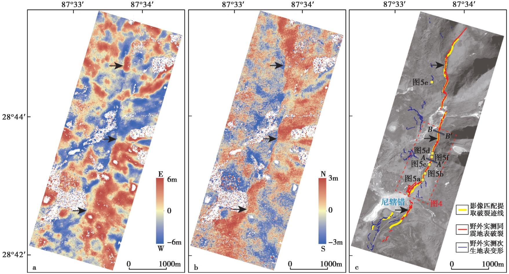
Fig. 3 Co-seismic deformation field and surface rupture trace of the Dingri MW7.1 earthquake derived from correlation of GF-2 satellite images.
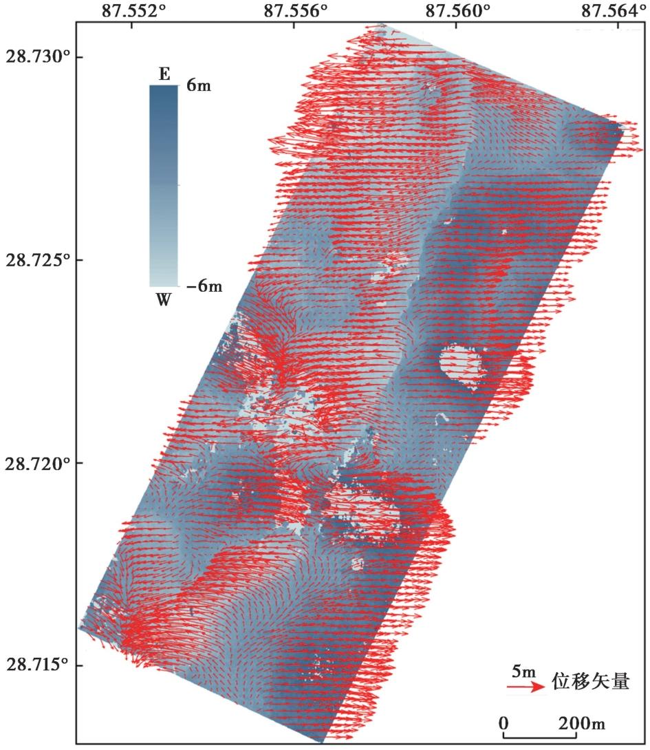
Fig. 4 Co-seismic displacement vector field of the Dingri earthquake, northeast of the Nixia Co.
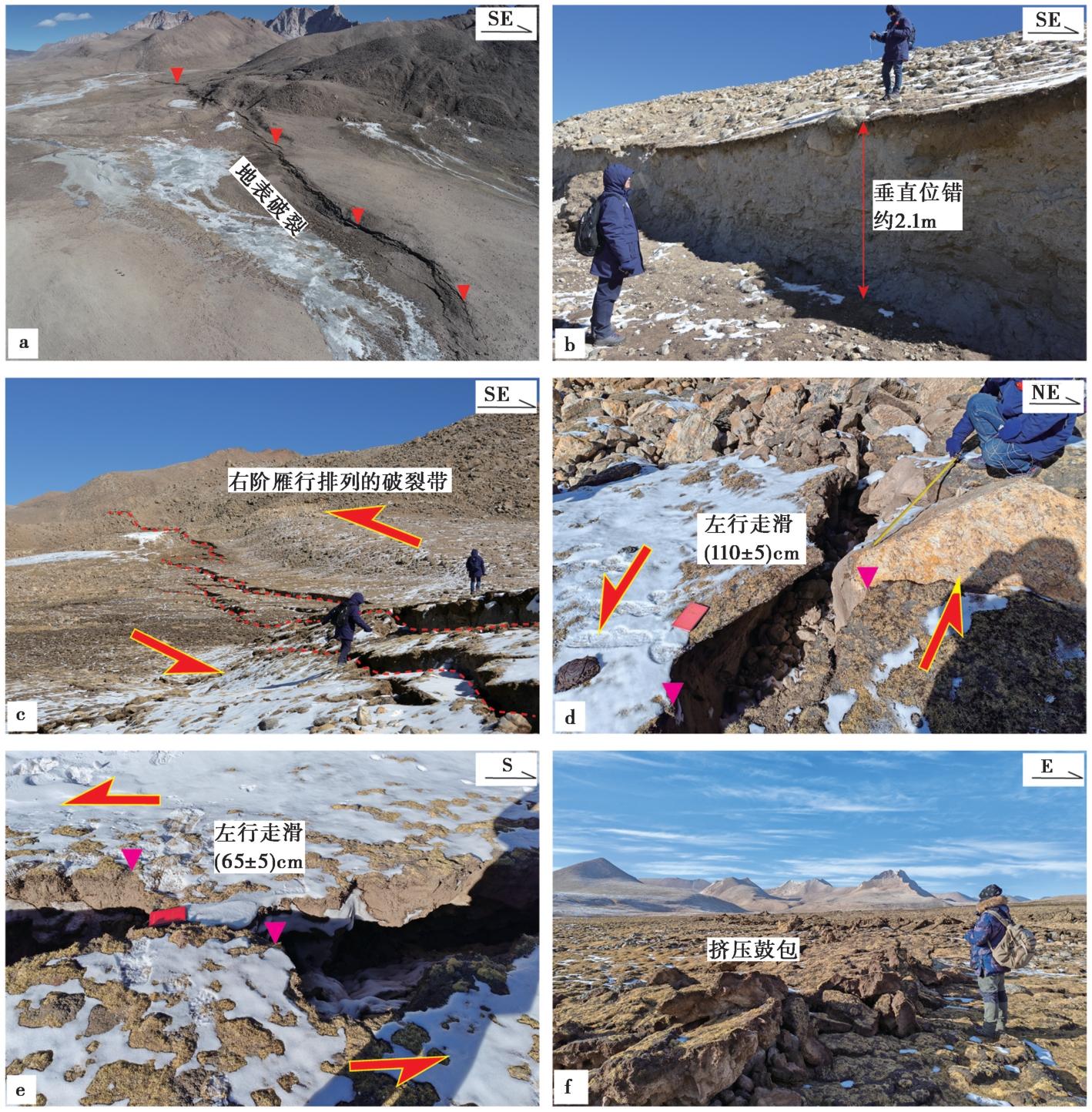
Fig. 5 Field photographs showing typical surface deformation produced by the Dingri earthquake.
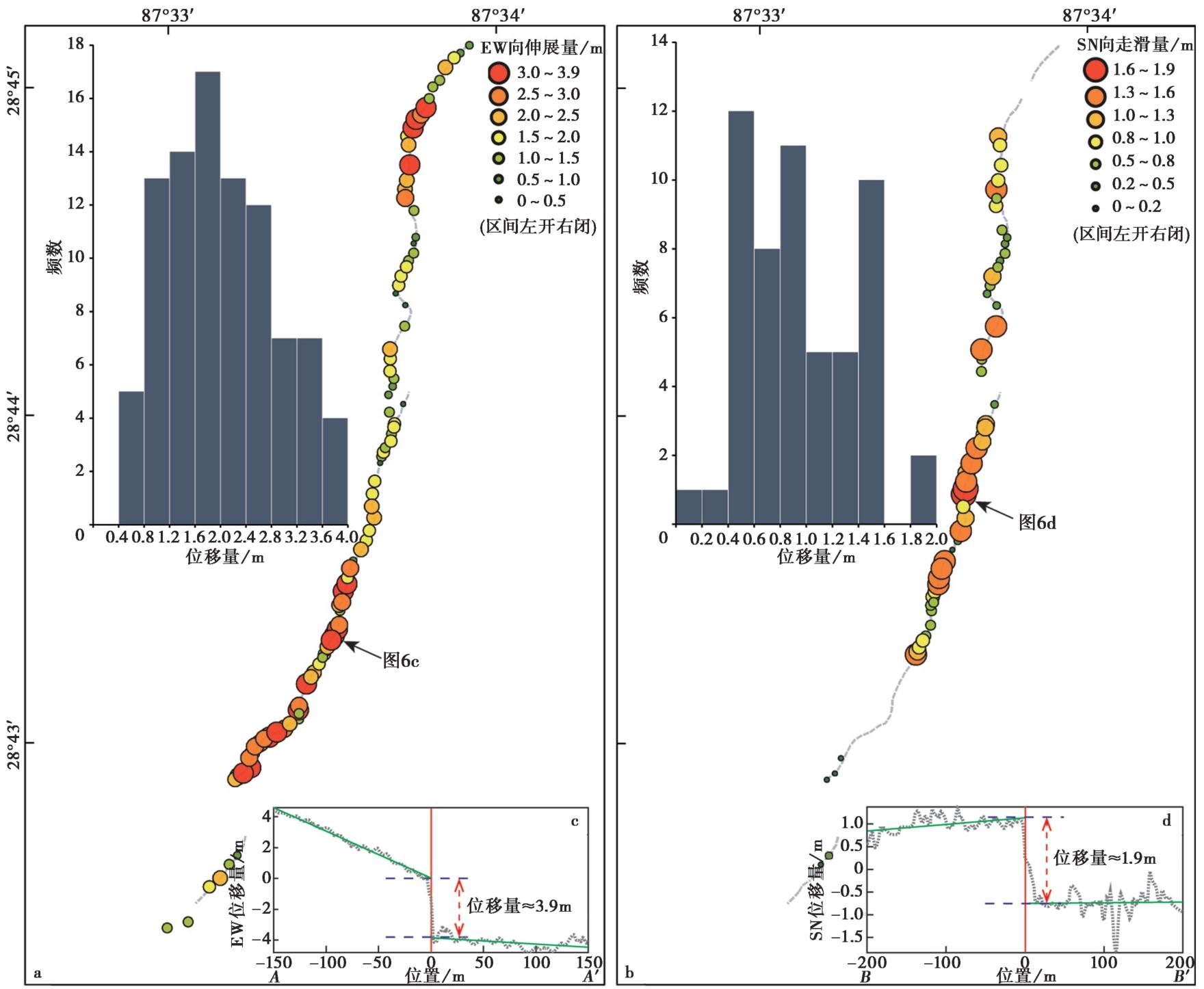
Fig. 6 Distribution of co-seismic displacement along the Nixia Co segment of the surface rupture zone produced by the Dingri earthquake.
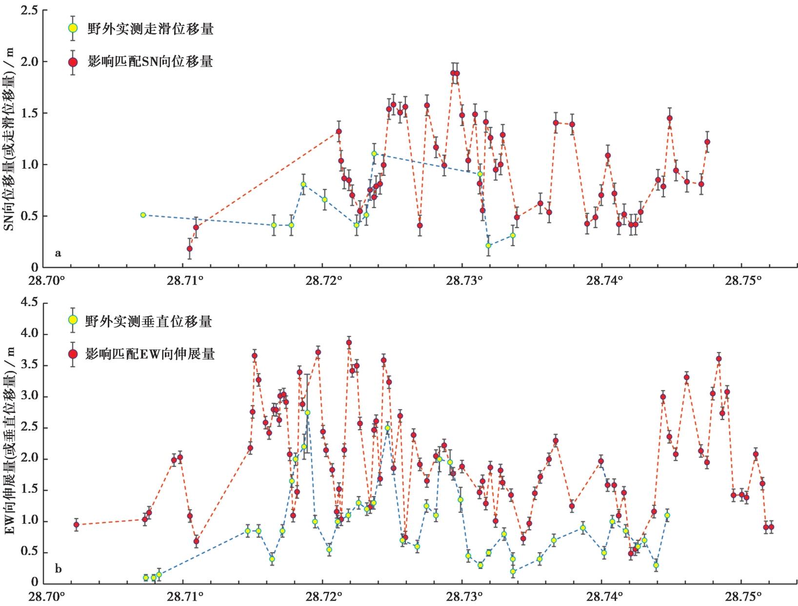
Fig. 7 Comparison of co-seismic displacement derived from image correlation result to field measurements.
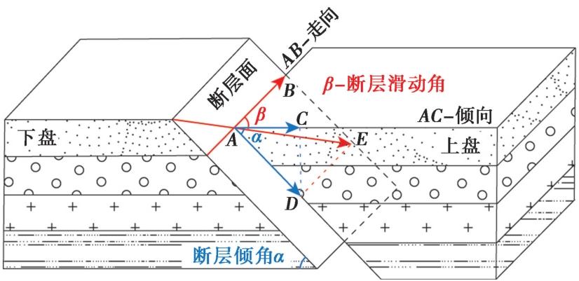
Fig. 8 Schematic diagram of fault slip.
| [1] |
卞爽, 于志泉, 龚俊峰, 等. 2021. 青藏高原近SN向裂谷的时空分布特征及动力学机制[J]. 地质力学学报, 27(2): 178-194.
|
|
|
|
| [2] |
邓起东. 2007. 中国活动构造图[CM]. 北京: 地震出版社.
|
|
|
|
| [3] |
黄婷, 吴中海, 韩帅, 等. 2024. 西藏日喀则地区的活断层基本特征及地震灾害潜在风险评估[J]. 地震科学进展, 54(10): 696-711.
|
|
|
|
| [4] |
李雨森, 李为乐, 许强, 等. 2025. 2025年1月7日西藏定日 MS6.8 地震InSAR同震形变探测与断层滑动分布反演[J]. 成都理工大学学报(自然科学版), 52(2): 199-211.
|
|
|
|
| [5] |
刘富财, 潘家伟, 李海兵, 等. 2025. 2025年 MW7.1 西藏定日地震地表破裂与同震位移分布特征[J]. 地质学报, 99(3): 685-703.
|
|
|
|
| [6] |
邵延秀, 王爱生, 刘静, 等. 2025. 2025年1月7日西藏定日地震地表破裂特征和野外同震位移测量初步结果[J]. 地球科学, 50(5): 1677-1695.
|
|
|
|
| [7] |
石峰, 梁明剑, 罗全星, 等. 2025. 2025年1月7日西藏定日6.8级地震发震构造与同震地表破裂特征[J]. 地震地质, 47(1): 1-15. doi: 10.3969/j.issn.0253-4967.2025.01.001.
|
|
DOI |
|
| [8] |
谭莎莎, 杨莹辉, 许强, 等. 2025. 2025年1月7日西藏定日县 MS6.8 强震地表同震形变特征与房屋建筑震损分析[J]. 成都理工大学学报(自然科学版), 52(2): 212-222.
|
|
|
|
| [9] |
田婷婷. 2021. 申扎-定结裂谷南段丁木错断裂晚第四纪古地震事件研究[D]. 北京: 中国地质大学(北京).
|
|
|
|
| [10] |
田婷婷, 吴中海. 2023. 西藏申扎-定结裂谷南段丁木错正断层的最新史前大地震事件及其地震地质意义[J]. 地质论评, 69(S1): 53-55.
|
|
|
|
| [11] |
王楠, 李永生, 申文豪, 等. 2025. 2025年1月7日西藏定日 MS6.8 地震震源机制InSAR反演及强地面运动快速模拟[J]. 武汉大学学报(信息科学版), 50(2): 404-411.
|
|
|
|
| [12] |
吴中海, 赵希涛, 吴珍汉, 等. 2005. 西藏安多-错那湖地堑的第四纪地质、 断裂活动及其运动学特征分析[J]. 第四纪研究, 25(4): 490-502.
|
|
|
|
| [13] |
徐心悦. 2019. 藏南申扎-定结断裂系卡达正断裂晚第四纪活动性及其环境效应[D]. 北京: 中国地震局地质研究所.
|
|
|
|
| [14] |
张进江, 丁林. 2003. 青藏高原EW向伸展及其地质意义[J]. 地质科学, 38(2): 179-189.
|
|
|
|
| [15] |
张进江, 郭磊, 丁林. 2002. 申扎-定结正断层体系中, 南段构造特征及其与藏南拆离系的关系[J]. 科学通报, 47(10): 738-743.
|
|
|
|
| [16] |
|
| [17] |
DOI URL |
| [18] |
DOI URL |
| [19] |
DOI URL |
| [20] |
DOI URL |
| [21] |
|
| [22] |
DOI URL |
| [23] |
DOI URL |
| [24] |
|
| [25] |
|
| [26] |
DOI URL |
| [27] |
DOI URL |
| [28] |
DOI URL |
| [29] |
DOI |
| [30] |
DOI URL |
| [31] |
|
| [32] |
DOI URL |
| [33] |
DOI URL |
| [34] |
DOI |
| [35] |
DOI URL |
| [36] |
|
| [37] |
DOI URL |
| [38] |
DOI URL |
| [39] |
|
| [40] |
DOI URL |
| [41] |
PMID |
| [42] |
|
| [43] |
DOI URL |
| [44] |
DOI URL |
| [45] |
|
| [46] |
DOI URL |
| [47] |
DOI URL |
| [48] |
DOI URL |
| [49] |
DOI URL |
| [50] |
PMID |
| [51] |
DOI URL |
| [52] |
PMID |
| [53] |
DOI URL |
| [54] |
DOI |
| [55] |
|
| [56] |
DOI URL |
| [57] |
DOI URL |
| [1] | JIANG Li-xin, LIU Qin, DONG Xiang, XI Nan, XIAO Ben-fu, YANG Li-chen, YANG Zhi-gao, LIANG Ming-jian, DAI You-lin, TANG Cai-cheng, YE Zhao-heng, TAN Xin. CHARACTERISTICS OF DISASTER OF DINGRI M6.8 EARTHQUAKE IN XIZANG [J]. SEISMOLOGY AND GEOLOGY, 2026, 48(4): 1107-1121. |
| [2] | HUANG Ting, WU Fang, XIA Cai-xiang, LI Zhen-hong, DONG Xiao-peng, WU Zhong-hai, KOU Lin-lin. CHARACTERISTICS OF HOLOCENE CATASTROPIC EVENT LAYERS AND THEIR RELATIONSHIP WITH REGIONAL EARTHQUAKES IN THE SOUTHERN QINGSHUIHE BASIN, NINGXIA [J]. SEISMOLOGY AND GEOLOGY, 2025, 47(4): 1036-1057. |
| [3] | YANG Jiu-yuan, WEN Yang-mao, XU Cai-jun, YANG Jian-bing. SEISMOGENIC STRUCTURE OF THE DINGRI MW5.7 EARTH-QUAKE OF MARCH 20, 2020 (SOUTHERN QINGHAI-XIZANG PLATEAU) CONSTRAINED BY THE COSEISMIC AND POSTSEISMIC DEFORMATION [J]. SEISMOLOGY AND GEOLOGY, 2025, 47(4): 1292-1305. |
| [4] | ZHANG Da, SHI Feng, LUO Quan-xing, QIAO Jun-xiang, WANG xin, YI Wen-xing, LI Tao, LI an. THE MAXIMUM VERTICAL DISPLACEMENT OF THE MS6.8 EARTHQUAKE IN XIZANG AND ITS SURFACE DEFORMATION STYLE [J]. SEISMOLOGY AND GEOLOGY, 2025, 47(3): 707-717. |
| [5] | CHEN Han-lin, WANG Qin-cai, GAO Jin-rui, LI Jun. PRELIMINARY STUDY ON THE SEISMOGENIC STRUCTURE OF THE 2025 XIZANG DINGRI MS6.8 EARTHQUAKE SEQUENCE [J]. SEISMOLOGY AND GEOLOGY, 2025, 47(3): 747-760. |
| [6] | MENG Heng-zhou, YANG Guang-liang, QIN Hai-tao, TAN Hong-bo, LIU Sheng, WANG Jia-pei, HUANG Min-fu, ZHANG Ming-hui. HORIZONTAL DEVIATORIC STRESS AND ELASTIC LITHOSPHERE THICKNESS CHARACTERISTICS OF THE EPICENTER AND ITS ADJACENT AREAS OF THE DINGRI MS6.8 EARTHQUAKE, XIZANG, CHINA [J]. SEISMOLOGY AND GEOLOGY, 2025, 47(3): 761-776. |
| [7] | LIU Sheng, TAN Hong-bo, YANG Guang-liang, MENG Heng-zhou, QIN Hai-tao, WANG Jia-pei, HUANG Min-fu. INVERSION OF THE RUPTURE PROCESS OF THE XIZANG DINGRI MW7.1 EARTHQUAKE IN 2025 [J]. SEISMOLOGY AND GEOLOGY, 2025, 47(3): 777-788. |
| [8] | WAN Yong-ge, WANG Run-yan, JIN Zhi-tong, LAN Cong-xin. SOURCE CHARACTERISTICS OF THE 2025 DINGRI EARTHQUAKE AND ITS IMPLICATIONS FOR THE ACTIVITY OF THE SHENZHA-DINGJIE RIFT ZONE [J]. SEISMOLOGY AND GEOLOGY, 2025, 47(3): 806-819. |
| [9] | ZHANG Sheng-feng, ZHANG Yong-xian. AFTERSHOCK PROBABILISTIC FORECASTING AND TESTING OF OPERABILITY IN EARTHQUAKE FIELD INVESTIGATION ON-SITE: A CASE OF THE 2025 DINGRI MS6.8 EARTHQUAKE IN XIZANG [J]. SEISMOLOGY AND GEOLOGY, 2025, 47(3): 835-849. |
| [10] | YIN Xin-xin, ZUO Ke-zhen, ZHAO Cui-ping, CAI Run. RELOCATION AND FORESHOCK SEQUENCE IDENTIFICATION OF DINGRI MS6.8 EARTHQUAKE IN XIZANG [J]. SEISMOLOGY AND GEOLOGY, 2025, 47(3): 850-868. |
| [11] | WANG Peng, DAI Zong-hui, KONG Xue, LI Bo, XU Chang-peng, ZHANG Meng-xin. ANALYSIS ON THE EVOLUTION CHARACTERISTICS OF LOCAL STRESS FIELD IN THE MAGNITUDE 6.8 EARTHQUAKE SEQUENCE IN DINGRI, XIZANG [J]. SEISMOLOGY AND GEOLOGY, 2025, 47(3): 881-896. |
| [12] | YUAN Xiao-xiang, LIN Xu-chuan, CHEN Zi-feng, ZHANG Jian-long, DOU Ai-xia, XIAO Ben-fu, DU Hao-guo, YU Si-han, DING Xiang, FANG Jie, WANG Shu-min. COMPARATIVE STUDY ON BUILDING DAMAGE CAUSED BY THE 2025 MS6.8 EARTHQUAKE IN DINGRI, XIZANG, BASED ON REMOTE SENSING AND SEISMIC SIMULATION [J]. SEISMOLOGY AND GEOLOGY, 2025, 47(3): 932-948. |
| [13] | SHENG Shu-zhong, WANG Qian-ru, LI Zhen-yue, LI Hong-xing, ZHANG Xiao-juan, GE Kun-peng, GONG Meng. INVESTIGATION OF THE SEISMOGENIC STRUCTURE OF THE 2025 DINGRI MS6.8 EARTHQUAKE IN XIZANG BASED ON THE TECTONIC STRESS FIELD PERSPECTIVE [J]. SEISMOLOGY AND GEOLOGY, 2025, 47(1): 49-63. |
| [14] | LI Shu-yu, GAO Yuan, JIN Hong-lin, LIU Tong-zhen. CHARACTERISTICS OF UPPER CRUSTAL SHEAR WAVE SPLITTING IN THE NORTHEASTERN TIBETAN PLATEAU [J]. SEISMOLOGY AND GEOLOGY, 2024, 46(4): 916-933. |
| [15] | LI Dan-dan, TANG Xin-gong, XIONG Zhi-tao. CRUSTAL DENSITY STRUCTURE OF THE EASTERN TIBETAN PLATEAU AND ITS GEODYNAMIC IMPLICATIONS [J]. SEISMOLOGY AND GEOLOGY, 2023, 45(4): 936-951. |
| Viewed | ||||||
|
Full text |
|
|||||
|
Abstract |
|
|||||
Copyright © SEISMOLOGY AND GEOLOGY, All Rights Reserved.
Tel: 010-62009049/9063 E-mail: dzdz@ies.ac.cn
Powered by Beijing Magtech Co., Ltd.