SEISMOLOGY AND EGOLOGY ›› 2022, Vol. 44 ›› Issue (1): 35-45.DOI: 10.3969/j.issn.0253-4967.2022.01.003

• Research paper • Previous Articles     Next Articles

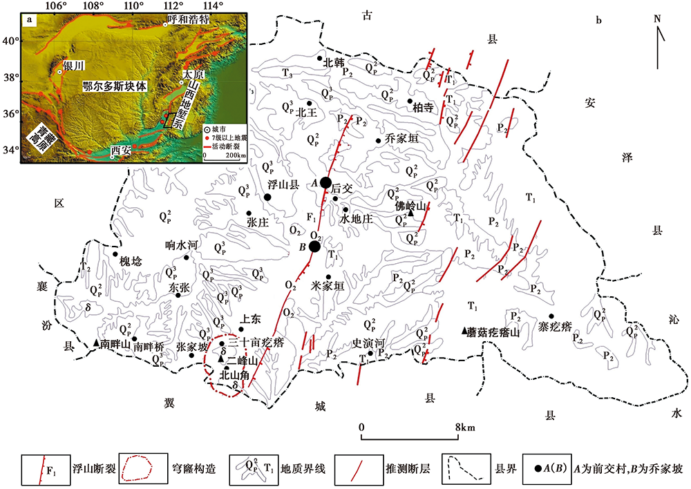
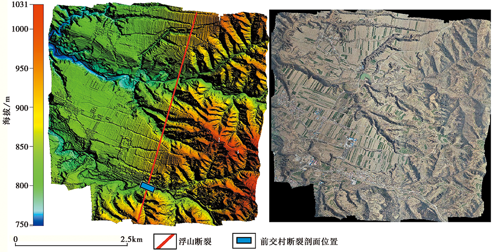
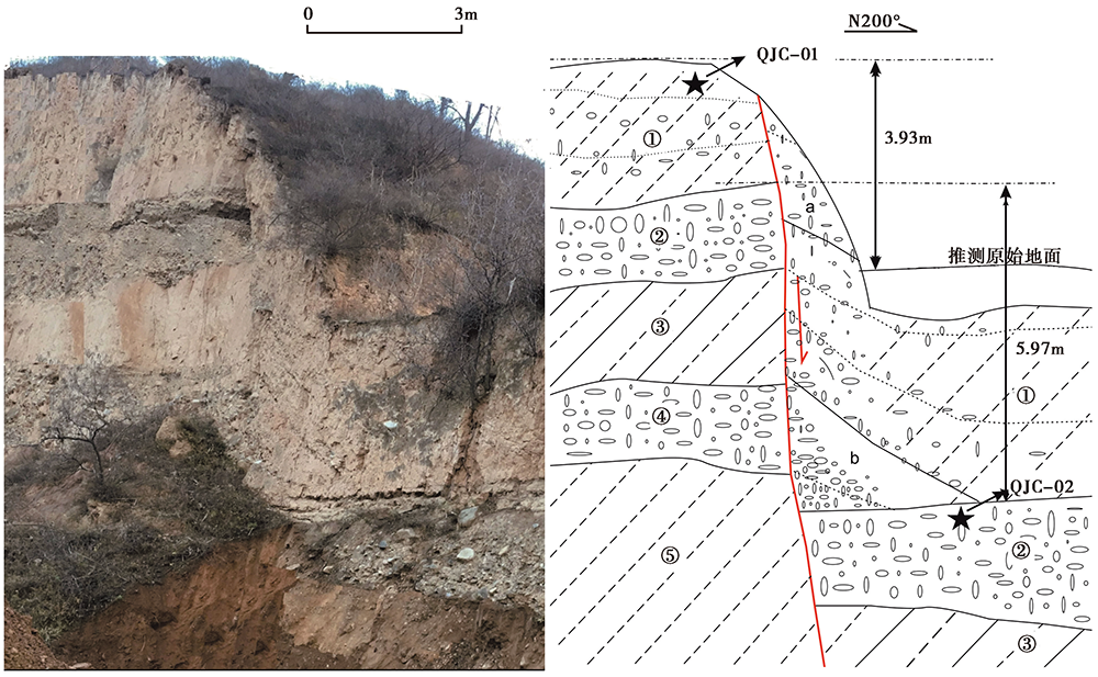
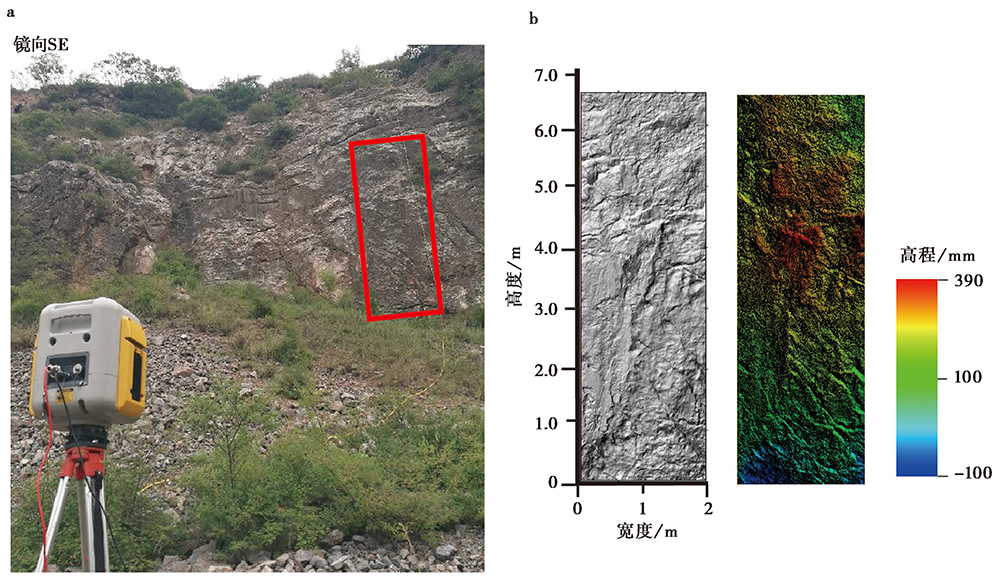
THE LATE QUATERNARY ACTIVITY AND DISPLACEMENT RATE OF FUSHAN FAULT IN SHANXI

YAN Xiao-bing1)(), ZHOU Yong-sheng2),*(), LI Zi-hong1), HU Gui-rang1), REN Rui-guo1), HAO Xui-jing1)   

  1. 1) Institute of Earthquake Disasters, Shanxi Earthquake Agency, Taiyuan 030002, China
    2) State Key Laboratory of Earthquake Dynamics, Institute of Geology, China Earthquake Administration, Beijing 100029, China
  • Received:2021-08-31 Online:2022-02-20 Published:2022-04-20
  • Contact: ZHOU Yong-sheng

山西浮山断裂的晚第四纪活动与位移速率

闫小兵1)(), 周永胜2),*(), 李自红1), 扈桂让1), 任瑞国1), 郝雪景1)   

  1. 1)山西省地震局, 太原 030002
    2)中国地震局地质研究所, 地震动力学国家重点实验室, 北京 100029
  • 通讯作者: 周永胜
  • 作者简介:闫小兵, 男, 1978年生, 2008年于中国地震局地质研究所构造地质学硕士学位, 高级工程师, 主要从事活动构造和构造地貌学研究, 电话: 13466852098, E-mail: 42953033@qq.com
  • 基金资助:
    山西省应用基础研究计划项目(201901D111463);中国地震局地震科技星火计划项目(XH18011);山西太原大陆裂谷动力学野外站计划项目(NORSTY20-05);中国地震局地震预测研究所基本科研业务专项(2017IES0101)

Abstract:

An earthquake of M6½ occurred near Fushan County in the 9th year of Dading Period of the Jin Dynasty(in 1209), which caused a large number of casualties and property losses. Many experts and scholars speculated that the Fushan Fault might be its seismogenic structure, but no in-depth research has been conducted, which greatly hinders the development of earthquake prevention and disaster reduction in the region. The Fushan Fault is located on the east side of the Linfen fault basin in the Shanxi fault depression zone. It is a boundary fault between the Linfen fault basin and the uplift area of the Taihangshan block. Predecessors have done little research on the Fushan Fault. This paper carries out a quantitative study on the late Quaternary activity and displacement rate of the Fushan Fault. First, we carried out remote sensing interpretation, fault surface excavation, collection and testing of fault geomorphological samples in the area of Qianjiao village of Fushan Fault. It is determined that the Fushan Fault starts from Hanzhuang village, Beihan Town in the north, extends to the southwest through Yushipo village, Fenghuangling village, Baozishang village, Zhaojiapo village in Beiwang town, Nanwang village, Zhuge village, Qianjiao village, Guojiapo village, Qiaojiapo village in Tiantan town, Dongguopo village and Zhaishang village in Zhangzhuang town, Lijiatu village and Zhujiashan village in Xiangshuihe town, and terminates in Chejiazhuang village in Xiangshuihe town, with a total length of 24km. The formation age of geomorphological bodies was obtained. It is determined that the latest stratum dislocation event of the fault is later than 7ka, and the fault is a Holocene active fault and has the ability to generate earthquakes of magnitude 7 and above. A total of two phases of stratum dislocation events have occurred on the Fushan Fault since 17ka BP(Late Quaternary): The first-phase event E1 occurred between 17ka and 7ka BP, producing a displacement of 2.04m, the average displacement rate of the Fushan Fault is 0.20mm/a; the second-phase event E2 occurred since 7ka BP, producing a displacement of 3.93m, and the average displacement rate of the Fushan Fault is 0.56mm/a. The displacement rate of the fault has been increasing since the Late Pleistocene. The future seismic hazard of this fault is worthy of attention. This paper also uses land-based LiDAR scanning to obtain the topographic data of the fault plane on the Qiaojiapo village bedrock section of the Fushan Fault(4.5km away from the Qianjiao village section). The isotropic variogram method was used to calculate the fractal dimensions of the fault surface morphology, and the morphological weathering zone was divided, and two phases of ancient seismic events of the Fushan Fault since the Late Quaternary were determined, which are, from old to new, the first-phase event E1 which caused a co-seismic displacement of 3.18m, and the second-phase event E2 which caused a co-seismic displacement of 2.51m. Studies have shown that the bedrock fault plane fractal method is an effective method for studying ancient seismic events in the bedrock area, and its ancient seismic period division is consistent with that of the sedimentary coverage area. Finally, this paper discusses the seismogenic structure of the 1209 Fushan earthquake with magnitude of 6½, and believes that the seismogenic structure of the Fushan earthquake is most likely to be the Fushan Fault. However, due to the lack of a lower age limit and that the only upper limit age is far away from the historical earthquake time, it is necessary to conduct a more detailed investigation and research on the fault to determine whether there can be a revelation of ancient earthquake events with a younger age and comparable magnitude.
This study has greatly improved Fushan County’s risk prevention and control, and territorial planning capabilities.

Key words: Fushan Fault, bedrock fault surface, displacement rate, Fushan earthquake in 1209

摘要:

金大定9年(1209年)浮山县城附近发生过6½级地震, 造成了大量的人员伤亡和财产损失, 许多专家学者推测浮山断裂可能是其发震构造, 但均未进行深入研究。浮山断裂位于山西断陷带临汾断陷盆地东侧, 为临汾断陷盆地和太行山断块隆起区的分界断裂, 前人对其研究较少。文中针对浮山断裂的晚第四纪活动和位移速率开展定量研究。首先, 对浮山断裂前交村一带进行遥感解译、 开挖断裂面、 采集并测试断错地貌年代学样品, 获取地质地貌体的形成时代, 确定该断裂最新一期的地层错断事件晚于距今7ka, 为全新世活动断裂, 具备发生7级及以上地震的能力。浮山断裂距今17ka(晚第四纪)以来共发生2期较为明显地层错断事件: 第1期发生于距今17~7ka期间, 造成了2.04m的地层错断量, 平均位移速率为0.2mm/a; 第2期发生于距今7ka以来, 造成了3.93m的地层错断量, 平均位移速率为0.56mm/a。晚更新世以来, 浮山断裂的位移速率有增大的趋势, 未来的地震危害性值得关注。之后使用陆基LiDAR扫描获取浮山断裂乔家坡村基岩断面(与前交村断面相距4.5km)的形貌数据, 采用各向同性变差函数法计算了断层面形貌的分维值并划分了形貌风化条带, 确定浮山断裂晚第四纪以来的2期地层错断事件造成的断错量由老到新分别为3.18m和2.51m。研究表明, 基岩断层面分形法是研究基岩区古地震事件期次的有效方法, 其地层错断事件划分和第四系断裂面错断事件的划分结果一致。最后, 文中对1209年浮山6½级地震的发震构造进行了探讨, 认为浮山地震的发震构造为浮山断裂的可能性最大。但由于缺少年代下限且仅有的上限年代与历史地震时间相距甚远, 需要对该断层开展更为详细的调查研究, 以确定是否存在年代更新、 震级相当的古地震事件。

关键词: 浮山断裂, 基岩断层面, 滑动速率, 1209年浮山地震

CLC Number: