SEISMOLOGY AND GEOLOGY ›› 2025, Vol. 47 ›› Issue (2): 610-626.DOI: 10.3969/j.issn.0253-4967.2025.02.20240158

Previous Articles     Next Articles

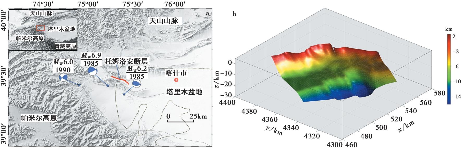
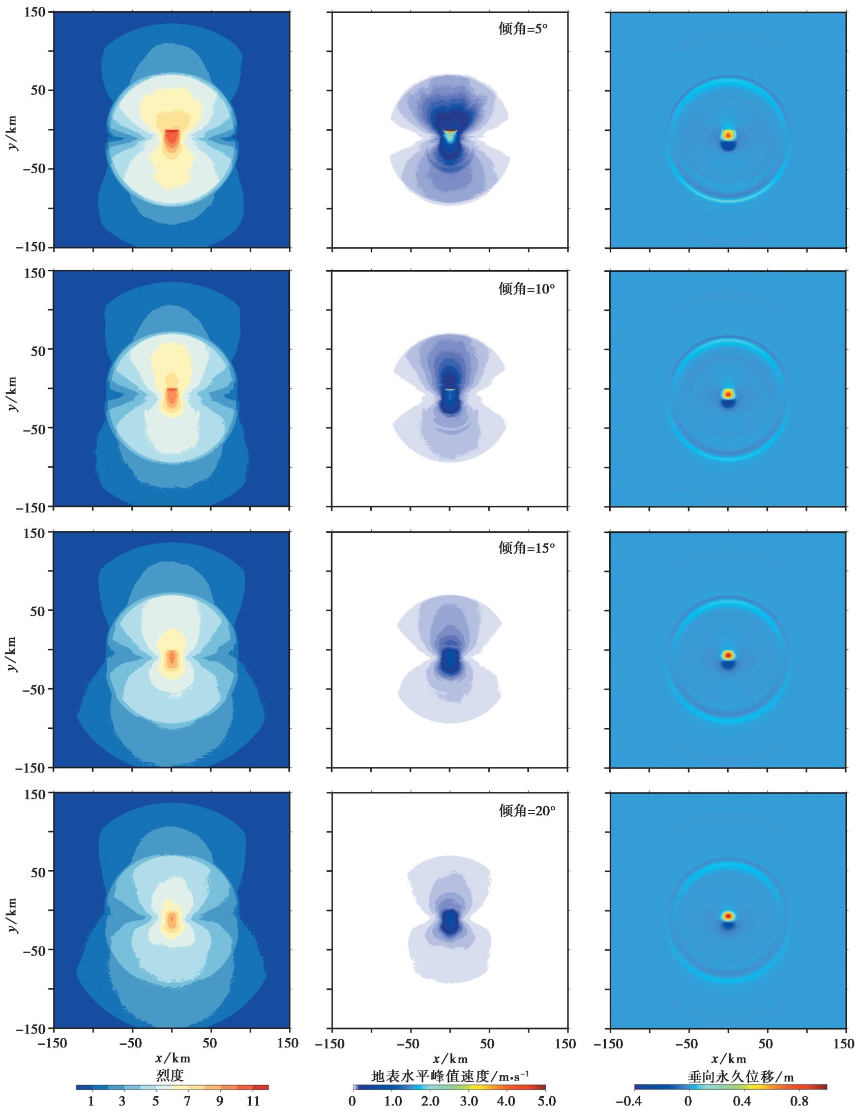
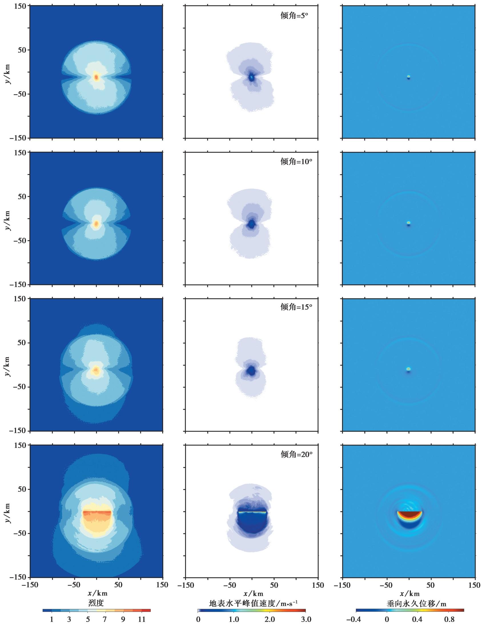
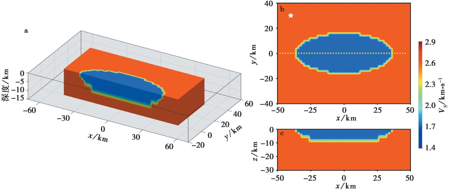
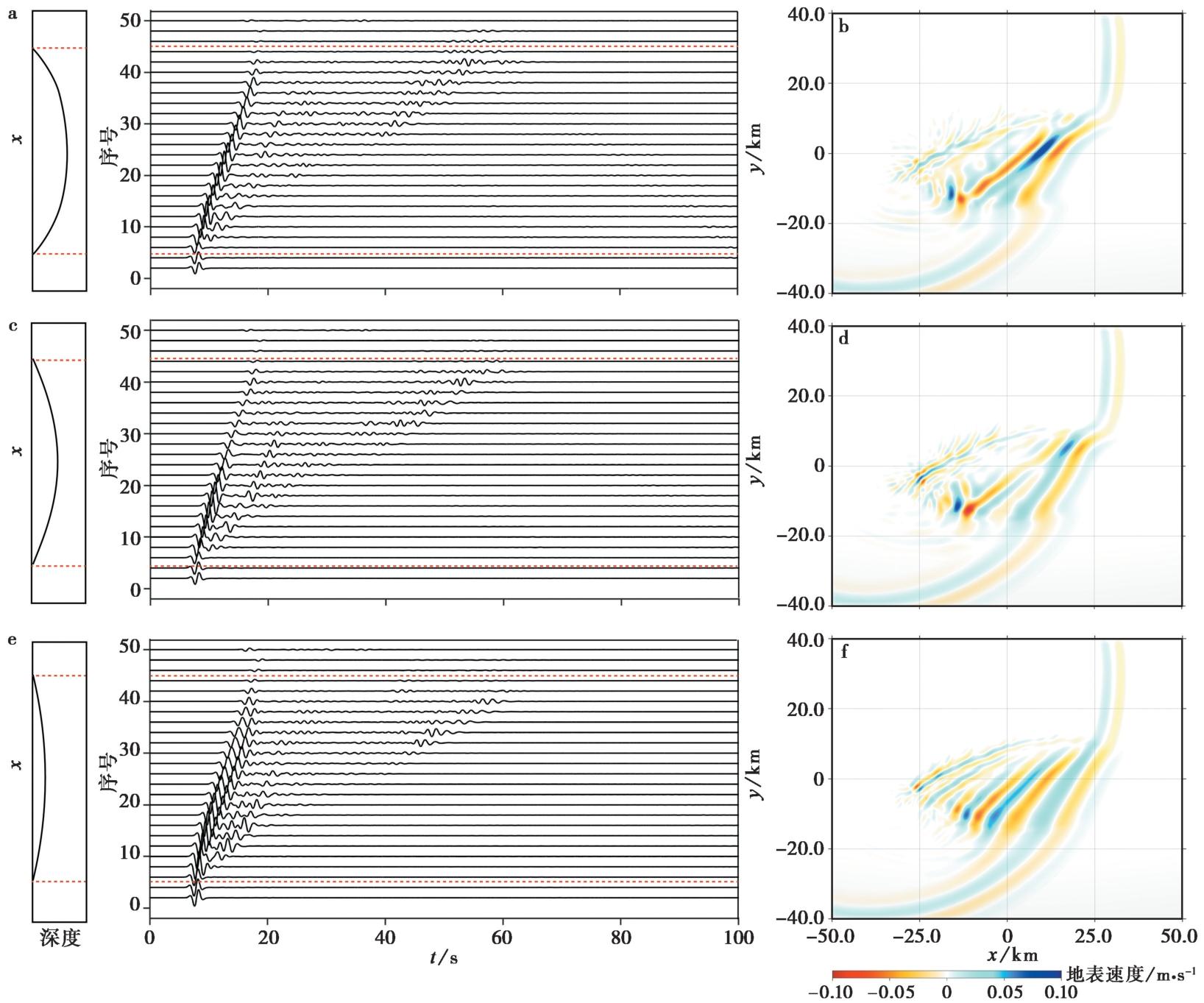
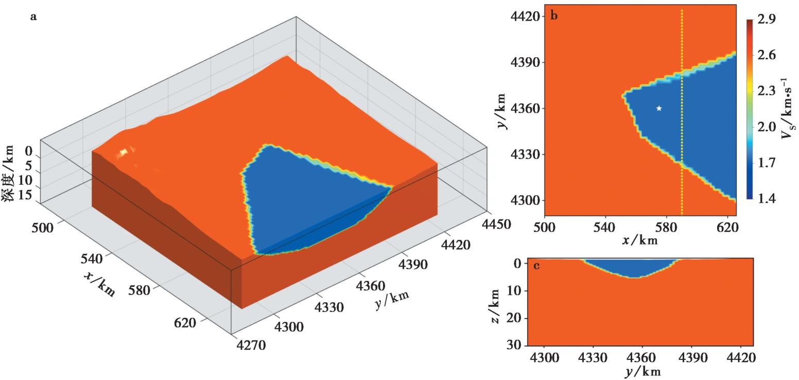
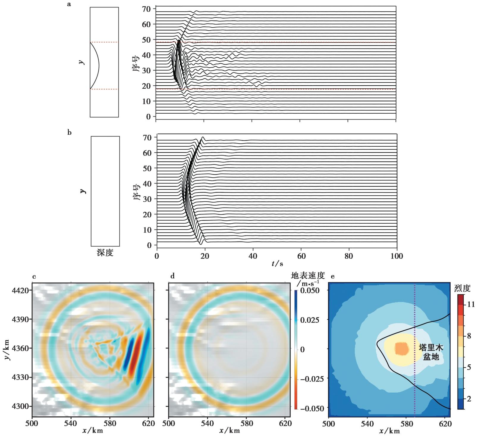
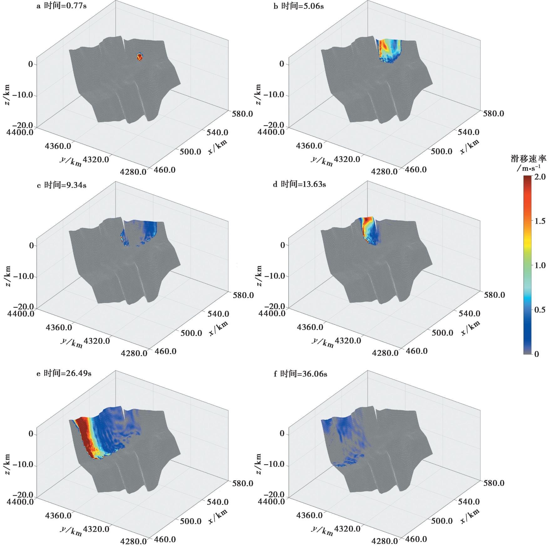
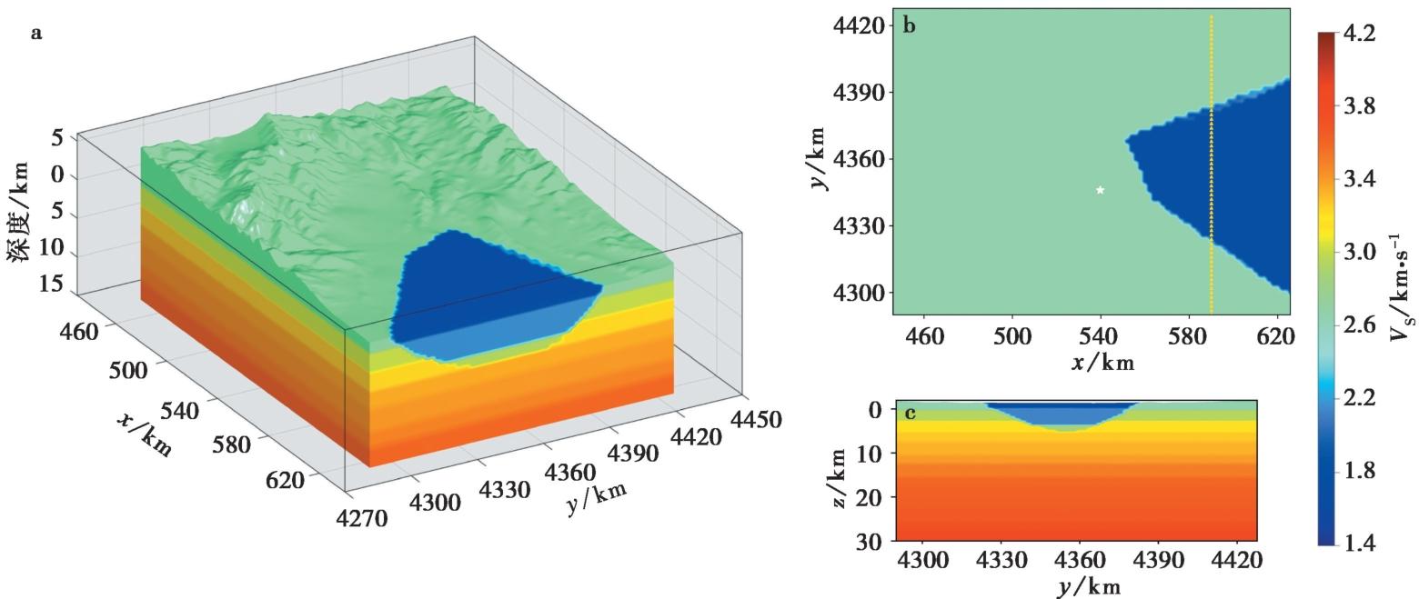
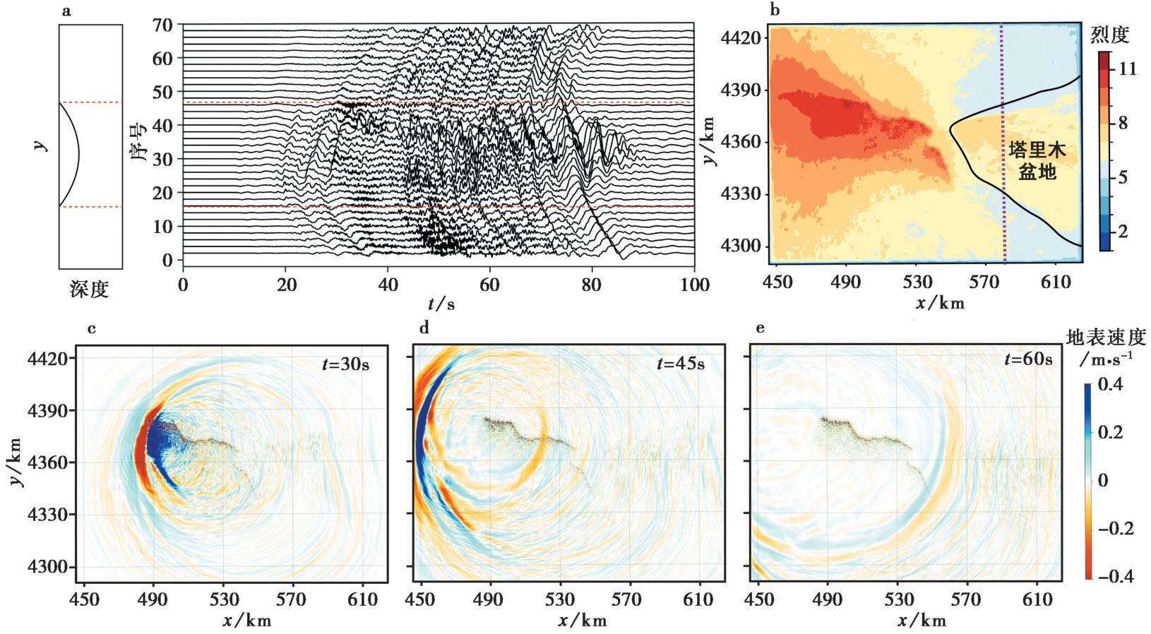
STUDY ON THE INFLUENCE OF LARGE LOW DIP THRUST FAULTS AND THICK BASINS ON STRONG GROUND MOTION: A STUDY IN KASHGAR AREA, XINJIANG, China

SHEN Zhu-yue1)(), ZHAO Shun1), SUN Yao-chong1),*(), XU Du-yuan2), YU Hou-yun3), ZANG Nan3), WANG Chun-jing3)   

  1. 1) State Key Laboratory of Marine Geology, Tongji University, Shanghai 200092, China
    2) Institute of Geology, China Earthquake Administration; Xinjiang Pamir Intracontinental Subduction National Observation and Research Station; State Key Laboratory of Earthquake Dynamics and Forecasting, Institute of Geology, China Earthquake Administration, Beijing 100029, China
    3) Department of Earth and Space Sciences, Southern University of Science and Technology, Shenzhen 518055, China
  • Received:2024-12-16 Revised:2025-02-23 Online:2025-04-20 Published:2025-06-07

大型低角度断层和巨厚沉积盆地对强地面运动的影响——以新疆喀什地区的逆断层为例

沈朱悦1)(), 赵顺1), 孙耀充1),*(), 徐杜远2), 余厚云3), 臧楠3), 王春静3)   

  1. 1) 同济大学, 海洋地质国家重点实验室, 上海 200092
    2) 新疆帕米尔陆内俯冲国家野外科学观测研究站, 地震动力学与强震预测全国重点实验室(中国地震局地质研究所), 北京 100029
    3) 南方科技大学, 地球与空间科学系, 深圳 518055
  • 通讯作者: * 孙耀充, 男, 1988年生, 助理教授, 主要从事计算地震学研究, E-mail:
  • 作者简介:

    沈朱悦, 女, 2002年生, 同济大学地球物理学在读研究生, 主要从事地震波传播模拟, 强地面运动的研究, E-mail:

  • 基金资助:
    国家重点研发计划项目(2022YFC3003700)

Abstract:

Since the Cenozoic era, the Xinjiang region has undergone significant geological evolution, resulting in numerous large-scale low-angle faults and extremely thick sedimentary basins. These unique geological features have profoundly influenced strong ground motion within the area, particularly in regions such as Kashgar, which is situated near the Pamir Plateau. This study focuses on the effects of the Tuomuluo’an Fault and the thick sedimentary layers of the Tarim Basin on seismic activity and the amplification of strong ground motion. Additionally, the Kashgar region’s geographical position south of the Tuomuluo’an front fault further highlights its vulnerability to complex seismic dynamics.
To comprehensively understand these phenomena, researchers developed a series of low-angle thrust fault models, thick sedimentary basin models, and strong ground motion models based on detailed data from the Tuomuluo’an fault system around Kashgar and sedimentary layer characteristics in the Tarim Basin. Numerical experiments were conducted using dynamic simulations of earthquake sources and seismic wave field propagation to analyze how fault dip angle, sedimentary layer thickness and earthquake source location influence strong ground motion.
The numerical experiments revealed several critical insights into the seismic behavior of the region. First, it was found that the Tuomuluo’an fault in the Kashgar region exhibits a greater tendency for earthquake ruptures to reach the surface when occurring along the upper ramp segment. This is due to the specific geometric configuration and stress conditions of this portion of the fault system. In contrast, ruptures along the lower slope are less likely to propagate to the surface, indicating that the fault’s dip angle significantly determines the likelihood of surface-breaking earthquakes. Second, the study demonstrated that the thick sedimentary basin of the Tarim Basin significantly amplifies strong ground motion in the Kashgar region. This amplification occurs because the soft, low-velocity sediments in the basin trap seismic waves and cause prolonged shaking, increasing ground motion intensity during an earthquake. To further investigate this phenomenon, a scenario earthquake was simulated with its nucleation location on the eastern segment upper ramp of the Tuomuluo’an fault. The results generated peak ground velocity and intensity maps essential for disaster assessment and planning.
The simulation revealed that earthquake disasters in the Kashgar area are divided into two distinct regions: one near the seismogenic fault extending along its direction, where strong shaking is expected to be most intense, and another above the Tarim thick sedimentary basin, where ground motion is significantly amplified due to the geological characteristics of basin. Additionally, complex terrain changes influenced earthquake disaster zones, highlighting the importance of topographical factors in determining seismic hazard distribution.
The study concludes that several key factors significantly affect strong ground motion in the Kashgar region: the dip angle and geometric shape of the Tuomuluo’an fault, the thickness of sedimentary layers, and the regional topography. These findings enhance our understanding of seismic hazard assessment in the area and provide valuable insights for disaster preparedness and mitigation strategies. The geological conditions of the Xinjiang region, characterized by large-scale low-angle faults and thick sedimentary basins since the Cenozoic era, further underscore the importance of these findings for regional earthquake risk evaluation.
This research provides critical scientific evidence to improve seismic hazard assessment in the Kashgar region. The study offers practical recommendations for enhancing earthquake preparedness and reducing potential disaster impacts in the Xinjiang region by identifying the key factors that influence strong ground motion.

Key words: large-scale low-angle fault, extremely thick sedimentary basin, strong ground motion simulation, seismic basin effect

摘要:

新生代以来, 新疆地区发育了很多大型低角度断层和巨厚沉积盆地, 它们对该地区的强地面运动产生重要影响。喀什地区位于塔里木盆地最西端、 向N低角度逆冲的帕米尔前缘断层托姆洛安段南侧, 其强地面运动同时受到大型低角度断层和巨厚沉积盆地的影响。文中根据喀什周边的托姆洛安断层数据和塔里木盆地的沉积层数据, 建立了一系列低角度逆断层模型、 巨厚沉积盆地模型和喀什地区的强地面运动模型, 通过震源动力学模拟和地震波场传播模拟, 研究了断层倾角、 沉积层厚度和震源位置对强地面运动的影响, 模拟了地震成核位置在托姆洛安断层东段上断坡的设定地震, 得到了可用于灾害评估的峰值速度和烈度图。文中研究表明, 托姆洛安断层更易在上断坡成核发生地震, 且地震破裂沿断层倾向方向会被较缓的断坪阻挡。此外, 喀什地区巨厚的沉积层会显著放大其强地面运动。

关键词: 大型低角度断层, 巨厚沉积盆地, 强地面运动模拟, 盆地边缘效应