
SEISMOLOGY AND GEOLOGY ›› 2025, Vol. 47 ›› Issue (5): 1456-1476.DOI: 10.3969/j.issn.0253-4967.2025.05.20240042
Previous Articles Next Articles
PRELIMINARY STUDY ON THE ABNORMAL CHARACTERISTICS OF INDUCED CURRENT DISTRIBUTION IN DAILY VARIATION OF GEOMAGNETIC FIELD DURING THE YANGBI MS6.4 EARTH-QUAKE BASED ON ABNORMAL POSITIONING OF VERTICAL COMPONENT OF STATION GEOMAGNETIC FIELD
SUN Jun-song1)( ), FENG Zhi-sheng1),*(), WU Ying-yan2), LI Hong-yu1), YANG Jie1)
- 1)Jiangsu Earthquake Agency, Nanjing 210014, China
2)Institute of Earthquake Forecasting, CEA, Beijing 100003, China
-
Received:2024-04-09Revised:2024-10-28Online:2025-10-20Published:2025-11-11
基于台站地磁垂直分量异常定位的漾濞MS6.4 地震地磁日变化感应电流分布异常特征
孙君嵩1)(), 冯志生1),*(), 吴迎燕2), 李鸿宇1), 杨杰1)
- 1)江苏省地震局, 南京 210014
2)中国地震局地震预测研究所, 北京 100003
-
通讯作者:冯志生, 男, 1961年生, 研究员, 主要从事地震地磁学研究工作, E-mail:fengzs2001@sohu.com 。 -
作者简介:孙君嵩, 男, 1993年生, 2018年于中国地震局兰州地震研究所获固体地球物理学硕士学位, 工程师, 主要从事地球电磁学研究工作, E-mail: junsong_sun@sina.com。
-
基金资助:中国地震局地震科技星火计划项目(XH22001YC); 中国地震局地震科技星火计划项目(XH25008D); 国家自然科学基金(42274107); 2024年度震情跟踪定向工作任务(2024010406); 江苏省地震局局长基金(202201); 中国地震局地震预测研究所基本科研业务专项(CEAIEF20220207)
Cite this article
SUN Jun-song, FENG Zhi-sheng, WU Ying-yan, LI Hong-yu, YANG Jie. PRELIMINARY STUDY ON THE ABNORMAL CHARACTERISTICS OF INDUCED CURRENT DISTRIBUTION IN DAILY VARIATION OF GEOMAGNETIC FIELD DURING THE YANGBI MS6.4 EARTH-QUAKE BASED ON ABNORMAL POSITIONING OF VERTICAL COMPONENT OF STATION GEOMAGNETIC FIELD[J]. SEISMOLOGY AND GEOLOGY, 2025, 47(5): 1456-1476.
孙君嵩, 冯志生, 吴迎燕, 李鸿宇, 杨杰. 基于台站地磁垂直分量异常定位的漾濞MS6.4 地震地磁日变化感应电流分布异常特征[J]. 地震地质, 2025, 47(5): 1456-1476.
share this article
Add to citation manager EndNote|Ris|BibTeX
URL: https://www.dzdz.ac.cn/EN/10.3969/j.issn.0253-4967.2025.05.20240042
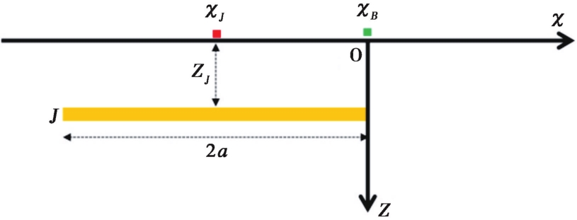
Fig. 1 Schematic diagram of surface current profile.
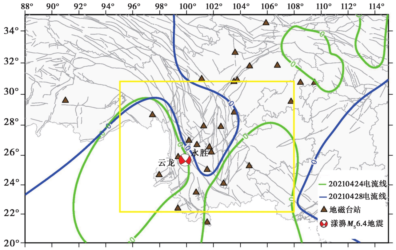
Fig. 2 Distribution of the geomagnetic stations, earthquakes and anomalies of linear concentrated induced current.
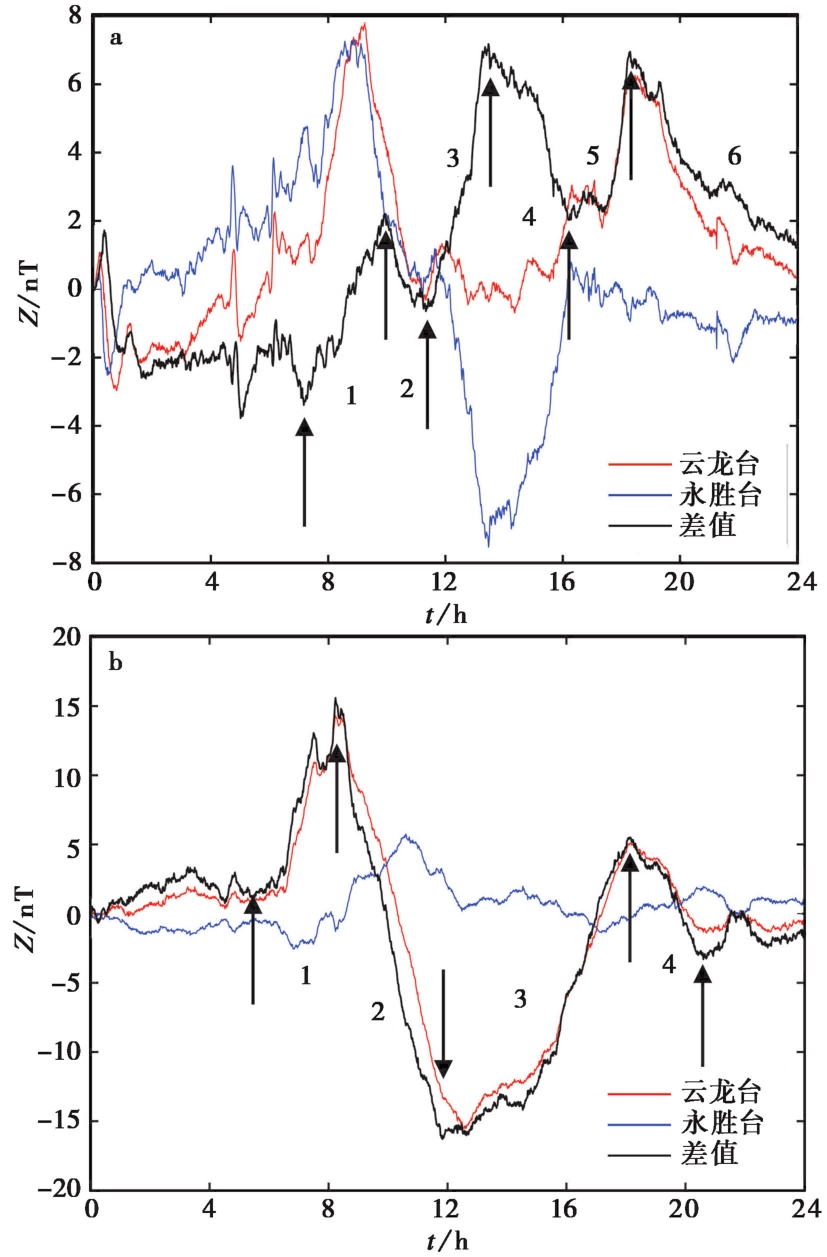
Fig. 3 Daily variation curves and difference curves of magnetic vertical component induction fields at Yongsheng and Yunlong stations.
| 图号 | 序号 | 开始时间 | 结束时间 | 持续时间/min | 差值变化幅度/nT |
|---|---|---|---|---|---|
| 1 | 7:00 | 10:00 | 180 | 5.71 | |
| 2 | 10:01 | 11:30 | 90 | 2.64 | |
| 3 | 11:31 | 14:30 | 180 | 7.67 | |
| 4 | 14:31 | 16:00 | 90 | 4.82 | |
| 5 | 16:01 | 18:00 | 120 | 4.53 | |
| 6 | 18:01 | 24:00 | 360 | 5.51 | |
| 1 | 5:00 | 8:00 | 180 | 14.28 | |
| 2 | 8:01 | 12:00 | 240 | 31.56 | |
| 3 | 12:01 | 19:00 | 420 | 21.32 | |
| 4 | 19:01 | 21:00 | 120 | 8.35 |
Table1 Parameters of reverse phase change events of geomagnetic induction field
| 图号 | 序号 | 开始时间 | 结束时间 | 持续时间/min | 差值变化幅度/nT |
|---|---|---|---|---|---|
| 1 | 7:00 | 10:00 | 180 | 5.71 | |
| 2 | 10:01 | 11:30 | 90 | 2.64 | |
| 3 | 11:31 | 14:30 | 180 | 7.67 | |
| 4 | 14:31 | 16:00 | 90 | 4.82 | |
| 5 | 16:01 | 18:00 | 120 | 4.53 | |
| 6 | 18:01 | 24:00 | 360 | 5.51 | |
| 1 | 5:00 | 8:00 | 180 | 14.28 | |
| 2 | 8:01 | 12:00 | 240 | 31.56 | |
| 3 | 12:01 | 19:00 | 420 | 21.32 | |
| 4 | 19:01 | 21:00 | 120 | 8.35 |
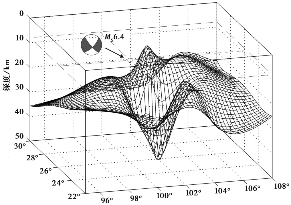
Fig. 4 Three dimensional distribution of induced current surface current in the vertical component of the geomagnetic induction field with opposite phase events.
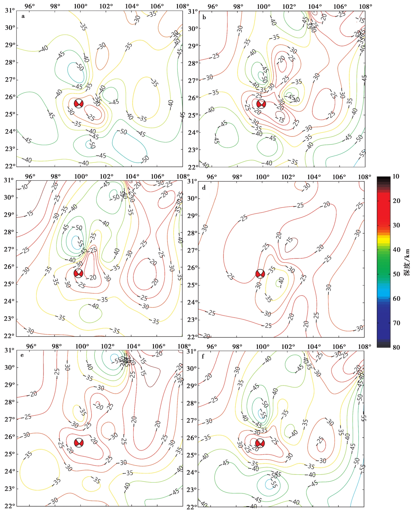
Fig. 5 Current contour lines on the event surface of the vertical component anti-phase of the geomagnetic induction field.
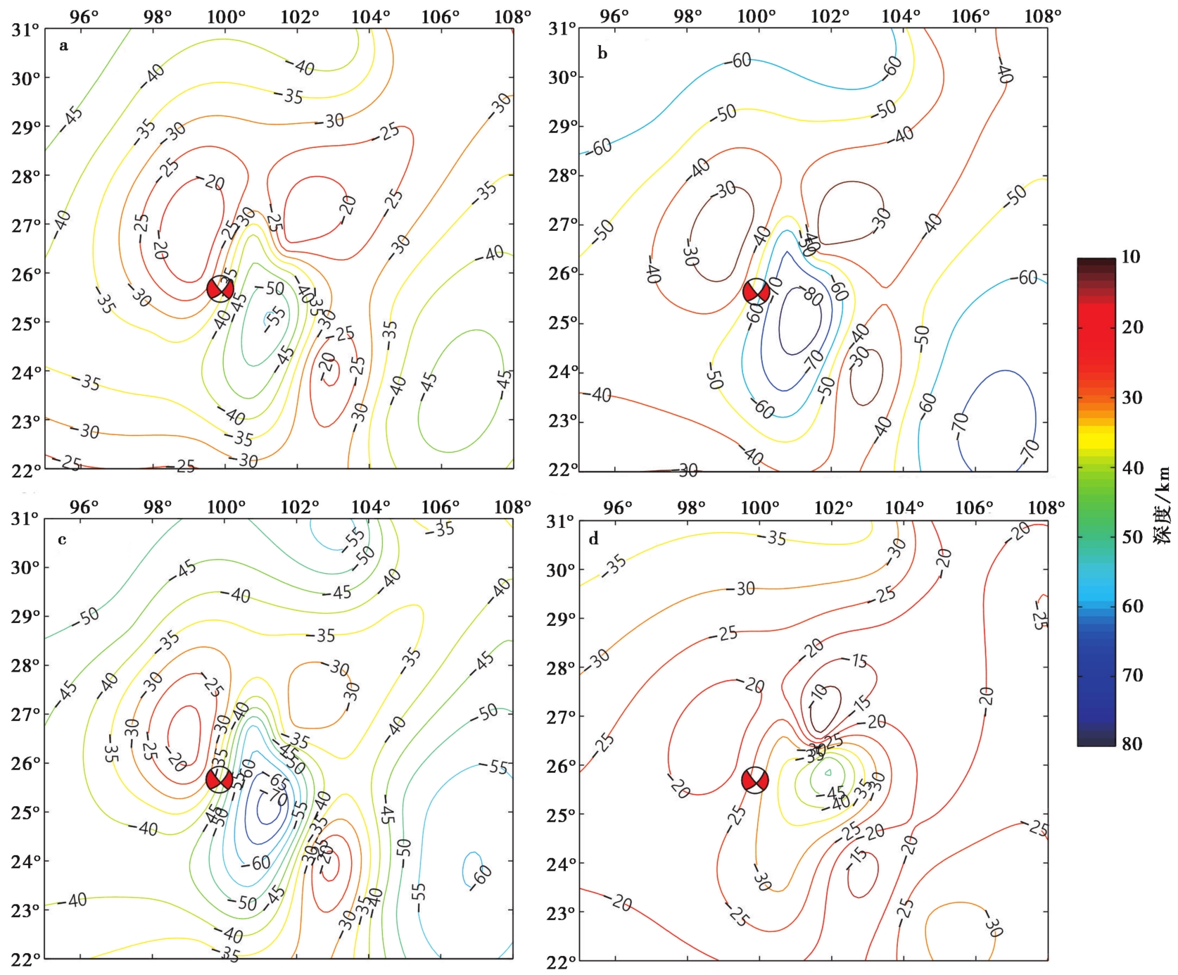
Fig. 6 Contour lines of induced current surface current during the anti-phase change event of the vertical component of the geomagnetic internal field.
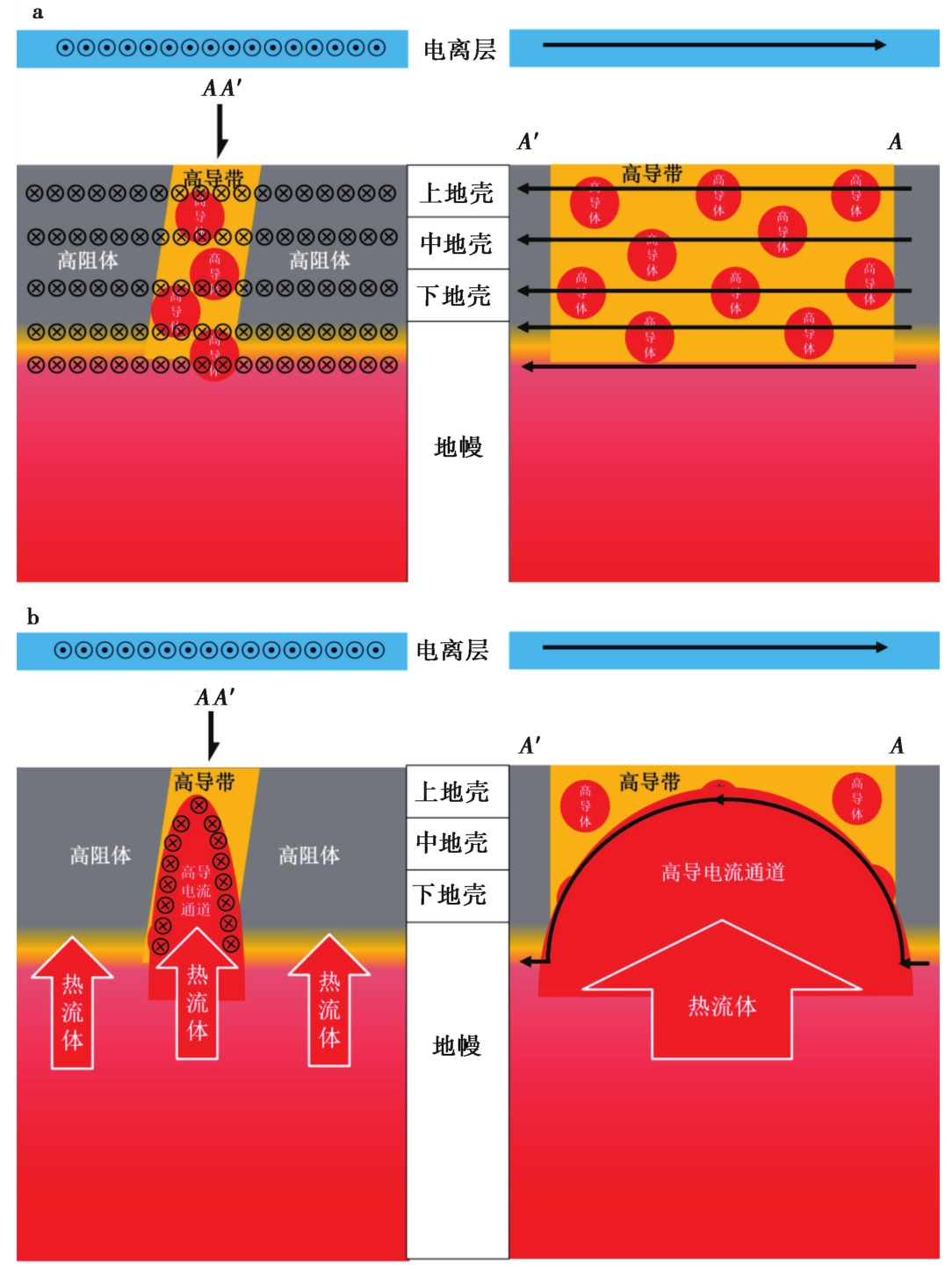
Fig. 7 Schematic model of short-term electrically connected high conductivity channel.
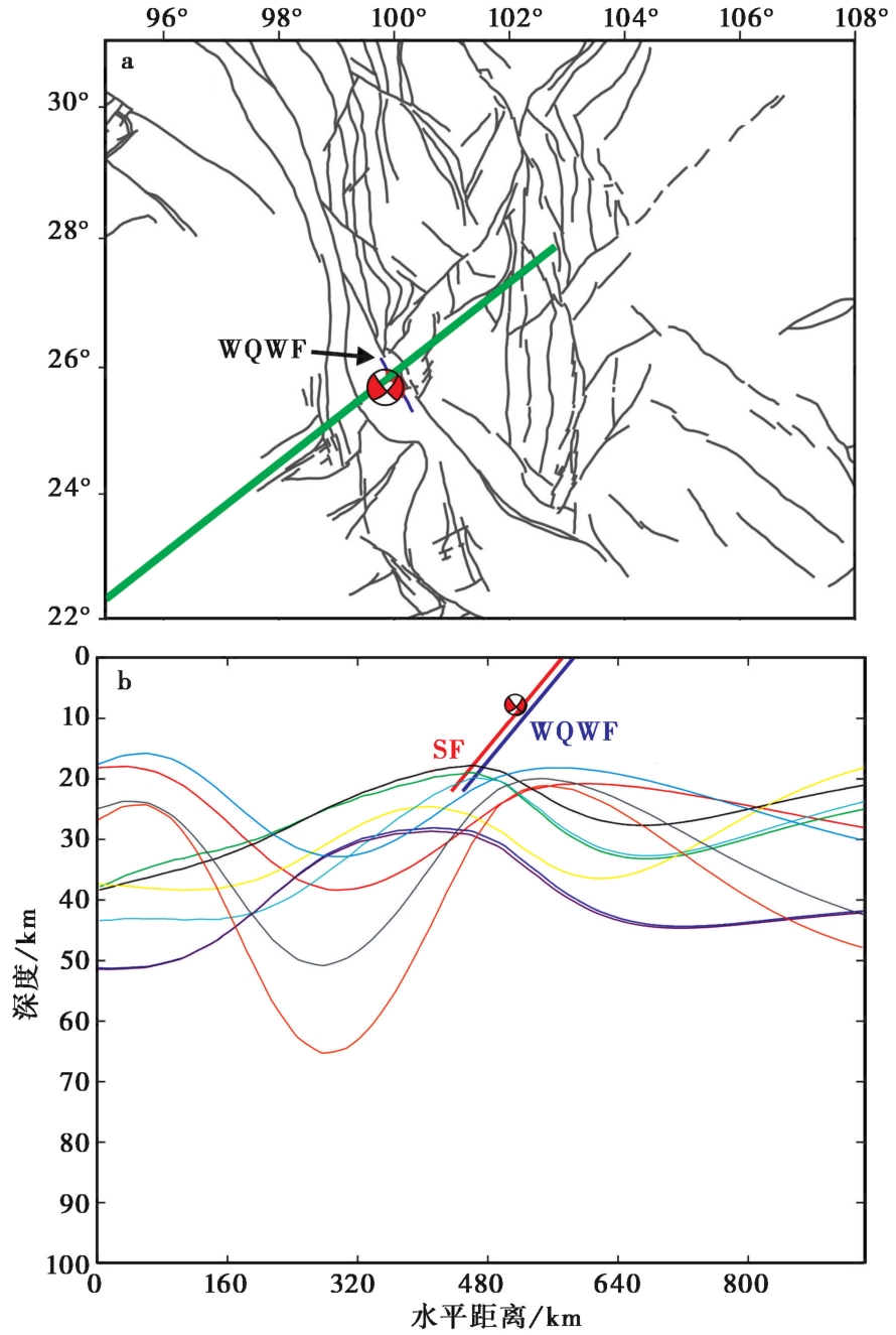
Fig. 8 Schematic diagram of the seismogenic structure and induced current profile of the Yangbi MS6.4 earthquake.
Fig. 9 Distribution and structure of current contour lines on the anti-phase event surface of the vertical component of the geomagnetic induction field.
| [2] |
陈伯舫. 1998. 研究地球深部电导率结构的Monte-Carlo反演法[J]. 华南地震, 18(2): 16-20.
|
|
|
|
| [3] |
陈绍明. 1987. 地磁日变低点位移分界线的网络分布及其与地震关系的探讨[J]. 地震, 6(5): 33-39.
|
|
|
|
| [4] |
陈章立, 李志雄. 2013. 地震预报的科学原理与逻辑思维[M]. 北京: 地震出版社.
|
|
|
|
| [5] |
戴勇, 冯志生, 吴迎燕, 等. 2022a. 地磁日变化感应电流异常与地震的成组特征初步分析[J]. 中国地震, 38(2): 199-212.
|
|
|
|
| [6] |
戴勇, 吴迎燕, 冯志生, 等. 2022b. 坚固体孕震模式的地磁日变化感应电流异常证据与完善: 以2016年杂多6.2级、 2017年九寨沟7.0级和2017年米林6.9级地震为例[J]. 地震地质, 44(6): 1574-1596. doi: 10.3969/j.issn.0253-4967.2022.06.013.
|
|
|
|
| [7] |
丁鉴海. 1994. 地震地磁学[M]. 北京: 地震出版社.
|
|
|
|
| [8] |
丁鉴海, 刘杰, 余素荣, 等. 2004a. 地磁日变化异常与强震的关系[J]. 地震学报, 26(S1): 79-87.
|
|
|
|
| [9] |
丁鉴海, 索玉成, 余素荣, 等. 2004b. 昆仑山口西8.1级地震前电离层与磁场短期异常对比研究[J]. 地震, 24(1): 104-111.
|
|
|
|
| [10] |
杜建国, 仵柯田, 孙凤霞. 2018. 地震成因综述[J]. 地学前缘, 25(4): 255-267.
|
|
|
|
| [11] |
杜学彬, 李宁, 叶青, 等. 2007. 强地震附近视电阻率各向异性变化的原因[J]. 地球物理学报, 50(6): 1802-1810.
|
|
|
|
| [12] |
范国华, 姚同起, 顾左文, 等, 1994. 琼州海峡地区地磁变化特征及其分析[J]. 地震学报, 16(2): 220-226.
|
|
|
|
| [13] |
冯志生, 范国华. 1990. 蒙特卡罗反演法的改进及其在大地电磁测深资料解释中的应用[J]. 地震学报, 12(3): 292-298.
|
|
|
|
| [14] |
冯志生, 姜楚峰, 冯丽丽, 等. 2020. 短期重现性地磁日变化感应电流集中分布与地震关系初步研究[J]. 中国地震, 36(3): 502-516.
|
|
|
|
| [15] |
冯志生, 李琪, 李鸿宇, 等. 2009. 地磁低点位移线两侧异常变化的反相位现象及其解释[J]. 中国地震, 25(2): 206-210.
|
|
|
|
| [16] |
冯志生, 林云芳, 王建宇, 等. 2000. 江苏地磁加卸载响应比的异常标志体系[J]. 地震, 21(2): 61-68.
|
|
|
|
| [17] |
冯志生, 王建宇, 蒋延林, 等. 2001. 地磁垂直分量日变幅逐日比及其与地震关系的探讨[J]. 华南地震, 21(2): 20-27.
|
|
|
|
| [18] |
韩亮, 周永胜, 姚文明. 2013. 中地壳断层带内微裂隙愈合与高压流体形成条件的模拟实验研究[J]. 地球物理学报, 56(1): 91-105.
|
|
|
|
| [19] |
姜楚峰, 吴迎燕, 冯志生, 等. 2022. 短期线状集中分布地磁日变化感应电流异常机理初步解释: 以2012年唐山4.8级地震为例[J]. 中国地震, 38(2): 226-238.
|
|
|
|
| [20] |
雷兴林, 王志伟, 马胜利, 等. 2021. 关于2021年5月滇西漾濞6.4地震序列特征及成因的初步研究[J]. 地震学报, 43(3): 261-286.
|
|
|
|
| [21] |
李大虎, 丁志峰, 吴萍萍, 等. 2021. 2021年5月21日云南漾濞 MS6.4 地震震区地壳结构特征与孕震背景[J]. 地球物理学报, 64(9): 3083-3100.
|
|
|
|
| [22] |
刘建, 陈丽琴. 2006. 无限长平面电流的磁场分布及计算机模拟[J]. 广西物理, 27(1): 29-31.
|
|
|
|
| [23] |
刘启元, 王峻, 陈九辉, 等. 2007. 1976年唐山大地震的孕震环境: 密集地震台阵观测得到的结果[J]. 地学前缘, 14(6): 205-213.
|
|
|
|
| [24] |
龙锋, 祁玉萍, 易桂喜, 等. 2021. 2021年5月21日云南漾濞 MS6.4 地震序列重新定位与发震构造分析[J]. 地球物理学报, 64(8): 2631-2646.
|
|
|
|
| [25] |
马瑾. 2016. 从“是否存在有助于预报的地震先兆”说起[J]. 科学通报, 61(4): 409-414.
|
|
|
|
| [26] |
梅世蓉, 冯德益, 张国民, 等. 1993. 中国地震预报概论[M]. 北京: 地震出版社.
|
|
|
|
| [27] |
倪晓寅, 陈莹, 杨锦玲. 2022. 地磁逐日比异常电磁学成因的进一步分析[J]. 中国地震, 38(2): 239-247.
|
|
|
|
| [28] |
牛树银, 侯泉林, 王宝德, 等. 2003. 华北地区拆离滑脱带控震作用初探[J]. 地震研究, 26(3): 257-264.
|
|
|
|
| [29] |
牛树银, 真允庆, 孙爱群, 等. 2019. 再论板块构造与地幔柱构造的相互关系: 从研究日本列岛-松辽盆地深部构造得到的启示[J]. 河北地质大学学报, 42(1): 1-20.
|
|
|
|
| [30] |
祁贵仲, 侯作中, 范国华, 等. 1981. 地震的感应磁效应(二)[J]. 地球物理学报, 24(3): 296-309.
|
|
|
|
| [31] |
荣扬名, 王桥, 丁霞, 等. 2012. 2011年日本东北大地震特低频地磁信号的分形标度特征研究[J]. 地球物理学报, 55(11): 3709-3717.
|
|
|
|
| [32] |
孙凤霞, 崔月菊, 杨帆, 等. 2022. 利用流体包裹体分析技术研究地震和断层活动的进展[J]. 中国地震, 38(3): 446-454.
|
|
|
|
| [33] |
孙君嵩, 吴迎燕, 李鸿宇, 等. 2023. 地磁低点位移内源场分布特征[J]. 地震, 43(2): 120-130.
|
|
|
|
| [34] |
孙昭杰, 杨杰, 李琪, 等. 2024. 结合构造应力场探究地磁转换函数异常[J]. 中国地震, 40(2): 389-398.
|
|
|
|
| [35] |
唐裕, 翁爱华, 杨悦, 等. 2021. 松原地震与流体作用联系的大地电磁证据[J]. 中国科学(地球科学), 51(1): 134-149.
|
|
|
|
| [36] |
田玥, 陈晓非. 2002. 地震定位研究综述[J]. 地球物理学进展, 17(1): 147-155.
|
|
|
|
| [37] |
吴忠良, 丁志峰. 2022. 地震科学实验场问答(五)[J]. 地震科学进展, 52(6): 285-288.
|
|
|
|
| [38] |
徐常芳. 1997. 壳内流体演化及地震成因(三)[J]. 地震学报, 19(2): 139-144.
|
|
|
|
| [39] |
徐文耀. 2009. 地球电磁现象物理学[M]. 合肥: 中国科学技术大学出版社.
|
|
|
|
| [40] |
徐文耀, 祁骙, 王仕明, 1978. 甘肃省东部地区短周期地磁变化异常及其与地震的关系[J]. 地球物理学报, 21(3): 218-224.
|
|
|
|
| [41] |
徐文耀, 朱岗昆. 1984. 我国及邻近地区地磁场的矩谐分析[J]. 地球物理学报, 27(6): 511-522.
|
|
|
|
| [42] |
徐志萍, 王夫运, 姜磊, 等. 2018. 川滇地区莫霍面深度和地壳厚度[J]. 地震地质, 40(6): 1318-1331. doi: 10.3969/j.issn.0253-4967.2023.06.009.
|
|
|
|
| [43] |
闫坤, 王伟君, 彭菲, 等. 2022. 2021年云南漾濞M6.4地震序列的发震构造和迁移特征[J]. 中国科学(地球科学), 52(10): 2023-2038.
|
|
|
|
| [44] |
杨帆, 孙凤霞, 刘轶男, 等. 2022. 地幔流体及其在地震孕育中的作用[J]. 中国地震, 38(3): 432-445.
|
|
|
|
| [45] |
杨九元, 温扬茂, 许才军. 2021. 2021年5月21日云南漾濞 MS6.4 地震: 一次破裂在隐伏断层上的浅源走滑事件[J]. 地球物理学报, 64(9): 3101-3110.
|
|
|
|
| [46] |
岳汉. 2023. 大地震破裂过程反演中的灵活性需求: 现状及探讨[J]. 地球与行星物理论评, 54(1): 1-11.
|
|
|
|
| [47] |
曾融生, 孙为国, 毛桐恩, 等. 1995. 中国大陆莫霍界面深度图[J]. 地震学报, 12(3): 322-327.
|
|
|
|
| [48] |
曾小苹, 续春荣, 赵明, 等. 1996. 地球磁场对太阳风的加卸载响应与地震[J]. 地震地磁观测与研究, 17(1): 49-53.
|
|
|
|
| [49] |
张荣华, 张雪彤, 胡书敏. 2010. 中地壳的水和水岩相互作用实验及其地球物理涵义[J]. 地球物理学报, 53(9): 2244-2256.
|
|
|
|
| [50] |
章鑫, 姚丽, 冯志生. 2020. 青藏高原东南缘深部地壳流与地磁日变化短时畸变源电流的联系[J]. 地球物理学报, 63(10): 3804-3817.
|
|
|
|
| [51] |
张媛媛, 周永胜. 2012. 断层脆塑性转化带的强度与变形机制及其流体和应变速率的影响[J]. 地震地质, 34(1): 172-194. doi: 10.3969/j.issn.0253-4967.2012.01.016.
|
|
|
|
| [52] |
中国地震局监测预报司. 2020. 地震电磁分析预测技术方法工作手册[M]. 北京: 地震出版社.
|
|
Department of Monitoring and Forecasting, China Earthquake Administration. 2020. Working Manual of Seismic Electromagnetic Analysis and Prediction Techniques[M]. Seismological Press, Beijing (in Chinese).
|
|
| [53] |
周永胜, 韩亮, 靖晨, 等. 2014. 龙门山断层脆-塑性转化带流变结构与汶川地震孕震机制[J]. 地震地质, 36(3): 882-895. doi: 10.3969/j.issn.0253-4967.2014.03.025.
|
|
|
|
| [54] |
周永胜, 何昌荣. 2009. 汶川地震区的流变结构与发震高角度逆断层滑动的力学条件[J]. 地球物理学报, 52(2): 474-484.
|
|
|
|
| [55] |
朱涛. 2021. 地震电阻率实验研究新进展及展望[J]. 地球与行星物理论评, 52(1): 61-75.
|
|
|
|
| [56] |
朱音杰, 罗艳, 赵里, 等. 2022. 利用区域宽频地震数据反演2021年5月云南漾濞 MS6.4 地震震源破裂过程[J]. 地球物理学报, 65(3): 1021-1031.
|
|
|
|
| [57] |
|
| [58] |
DOI URL |
| [59] |
|
| [60] |
|
| [1] |
鲍铁钊, 宁杰远. 2021. 利用虚拟地震测深方法研究川滇地区地壳厚度[J]. 华北地震科学, 39(2): 34-39.
|
|
|
|
| [61] |
DOI URL |
| [1] | XIE Tao, HAN Ying, LI Xin-yan, YU Chen, LI Xiao-fan, ZHANG Guo-ling, ZHANG Li-qiong, LIAO Xiao-feng. A VIEW OF STRATIFIED RESPOSE BASED ON SHORT-TERM CHANGES OF APPARENT RESISTIVITY AFTER STRONG EARTHQUAKE [J]. SEISMOLOGY AND GEOLOGY, 2026, 48(2): 351-369. |
| [2] | RUAN Ming-ming, TIAN Xiao-feng, ZHENG Cheng-long, SONG Xiang-hui, WANG Liang, HE Chang-xun, WANG Shuai-jun. REVEALING THE SHALLOW SEDIMENTARY STRUCTURE OF THE WESTERN WEIHE BASIN USING THE HVSR METHOD WITH A SHORT-PERIOD DENSE ARRAY [J]. SEISMOLOGY AND GEOLOGY, 2026, 48(2): 403-422. |
| [3] | LI Xi-bing, TAO Xiao-san, GU Qin-ping, PENG Xiao-bo, WANG Yu, ZHU Feng. P-WAVE VELOCITY STRUCTURE OF THE CRUST AND UPPER-MOST MANTLE IN THE CENTRAL AND SOUTHERN SEGMENT OF TANLU FAULT ZONE AND ITS TECTONIC IMPLICATION [J]. SEISMOLOGY AND GEOLOGY, 2026, 48(2): 423-441. |
| [4] | PAN Ji-shun, ZHANG Yun-tao, WANG Fu-yun, FENG Shao-ying, JI Ji-fa, QI Hui, TANG Yi-fan, WANG Xin-yu. JOINT TOMOGRAPHY OF FIRST ARRIVAL AND REFLECTION WAVES AND ITS APPLICATION ON SUBSURFACE STRUCTURE DETECTION IN THE HUHHOT-BAOTOU BASIN [J]. SEISMOLOGY AND GEOLOGY, 2026, 48(2): 582-596. |
| [5] | ZHANG Bo, WANG Ai-guo, FENG Zi-wei, HE Xiao-long, ZHU Jun-wen, YAO Yun-sheng, CAI Yi-meng. SEIMOTECTONIC ANALYSIS OF 2023 JISHISHAN MS6.2 EARTHQUAKE IN GANSU PROVINCE [J]. SEISMOLOGY AND GEOLOGY, 2025, 47(6): 1586-1605. |
| [6] | DAI Zong-hui, QU Jun-hao, XU Ning, LI Cui-qin, LI Dong-mei, YIN Yu-zhen. THREE-DIMENSIONAL WAVE VELOCITY STRUCTURE AND SEISMOGENIC STRUCTURE FOR THE 2023 WEISHAN EARTHQUAKE SWARM [J]. SEISMOLOGY AND GEOLOGY, 2025, 47(6): 1649-1666. |
| [7] | CAI Ming-gang, PENG Bai, LU Ren-qi, ZHANG Yang, LIU Guan-shen, XU Fang, TAO Wei, ZHANG Jin-yu, HAO Chong-tao. GEOMETRIC STRUCTURAL FEATURE OF THE TANGDONG FAULT IN THE SOUTHEASTERN MARGIN OF TAIHANG MOUNTAIN: BASED ON SHALLOW SEISMIC EXPLORATION AND 3D MODELING [J]. SEISMOLOGY AND GEOLOGY, 2025, 47(6): 1667-1687. |
| [8] | LI Ting-ting, MIAO Fa-jun, SUN Ye-jun, FAN Wen-hua, GONG Jie, GU Qin-ping, DU Hang, SUN Xiao-hang, ZHANG Cen, LI Zi-ye. THREE-DIMENSIONAL WAVE VELOCITY STRUCTURE AND SEISMOGENIC STRUCTURE FOR THE JIANGDU EARTHQUAKE SWARM IN JIANGSU [J]. SEISMOLOGY AND GEOLOGY, 2025, 47(5): 1343-1363. |
| [9] | ZHANG Tian-ji, QIN Min, DANG Wen-jie, JIN Ming-pei, LI Feng-ying, YANG Li-wei. THE S-WAVE VELOCITY STRUCTURE OF THE TENGCHONG-BAOSHAN REGION FROM JOINT INVERSION OF RECEIVER FUNCTION AND RAYLEIGH WAVE PHASE VELOCITY [J]. SEISMOLOGY AND GEOLOGY, 2025, 47(5): 1364-1381. |
| [10] | LI Lin-lin, JIANG Wen-liang, LI De-wen, JIAO Qi-song, LUO Yi, LI Yong-sheng, TIAN Yun-feng, LI Ying-ying. SURFACE RUPTURE CHARACTERISTICS OF THE JISHISHAN MS6.2 EARTHQUAKE ON DECEMBER 18, 2023 [J]. SEISMOLOGY AND GEOLOGY, 2025, 47(4): 1058-1074. |
| [11] | LI Ruo-hao, LEI Jian-she, SONG Xiao-yan. 3-D CRUSTAL S-WAVE VELOCITY STRUCTURE IN AND AROUND THE DATONG VOLCANIC GROUP: CONSTRAINTS FROM DIRECT TOMOGRAPHIC IMAGING OF AMBIENT-NOISE SURFACE WAVES [J]. SEISMOLOGY AND GEOLOGY, 2025, 47(4): 1090-1112. |
| [12] | YANG Jian-wen, JIN Ming-pei, YE Beng, CHA Wen-jian, HEI He-tang. THREE-DIMENSIONAL VELOCITY STRUCTURE AND SEI-SMOGENIC ENVIRONMENT IN THE MIDDLE AND UPPER CRUST OF NORTHWEST YUNNAN FROM AMBIENT NOISE TOMOGRAPHY [J]. SEISMOLOGY AND GEOLOGY, 2025, 47(4): 1113-1131. |
| [13] | GONG Meng, ZOU Xian-kun, WANG Xiao-shan, LI Guang, SHENG Shu-zhong, LI Hong-xing, XU Rong-hua, LU Chang-sheng. SIMULTANEOUS INVERSION OF CRUSTAL VELOCITY STRUCTURE AND EARTHQUAKE RELOCATION IN THE NORTHWEST OF THE BEIJING AREA [J]. SEISMOLOGY AND GEOLOGY, 2025, 47(4): 1132-1151. |
| [14] | ZHOU Ben-wei, FANG Li-hua, ZHANG Li-fen, WANG Jie, WANG Shi-guang, LIU Hua-biao. CONSTRUCTION OF A COMPLETE EARTHQUAKE CATALOG OF THE THREE GORGES SEISMIC NETWORK USING PALM AND THE GENESIS MECHANISM OF THE BADONG EARTHQUAKE SWARM FROM 2017 TO 2018 [J]. SEISMOLOGY AND GEOLOGY, 2025, 47(4): 1152-1166. |
| [15] | GUO Zhao-wu, LU Ren-qi, ZHANG Jin-yu, FANG Li-hua, LIU Guan-shen, WU Xi-yan, SUN Xiao, QI Shi-miao. THREE-DIMENSIONAL MODEL OF SEISMOGENIC FAULT AND SEISMIC ENVIRONMENT OF XIZANG DINGRI MS6.8 EARTHQUAKE OF JANUARY 7, 2025 [J]. SEISMOLOGY AND GEOLOGY, 2025, 47(3): 671-688. |
| Viewed | ||||||
|
Full text |
|
|||||
|
Abstract |
|
|||||
Copyright © SEISMOLOGY AND GEOLOGY, All Rights Reserved.
Tel: 010-62009049/9063 E-mail: dzdz@ies.ac.cn
Powered by Beijing Magtech Co., Ltd.