SEISMOLOGY AND GEOLOGY ›› 2026, Vol. 48 ›› Issue (2): 460-474.DOI: 10.3969/j.issn.0253-4967.20240137

• Research paper • Previous Articles     Next Articles

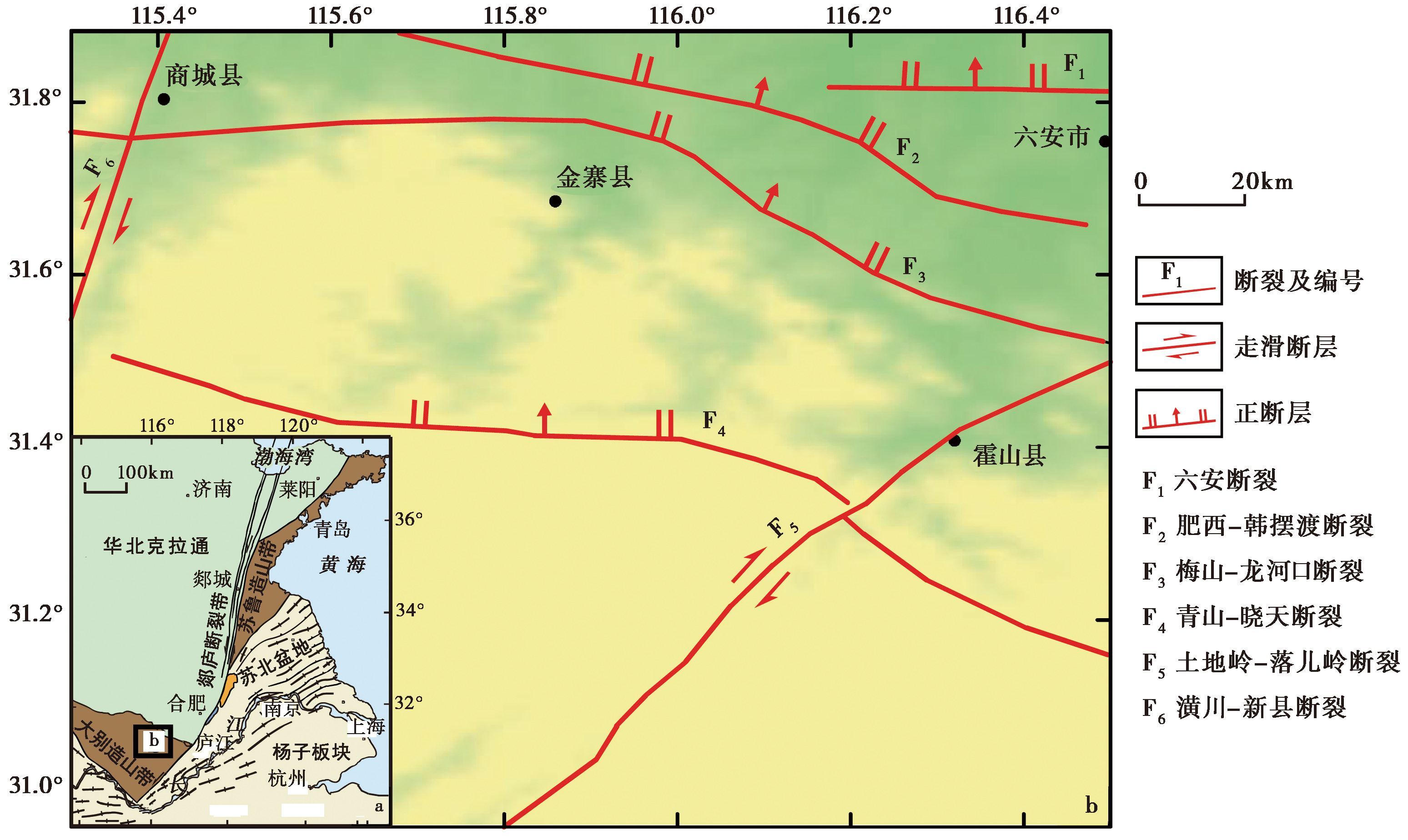
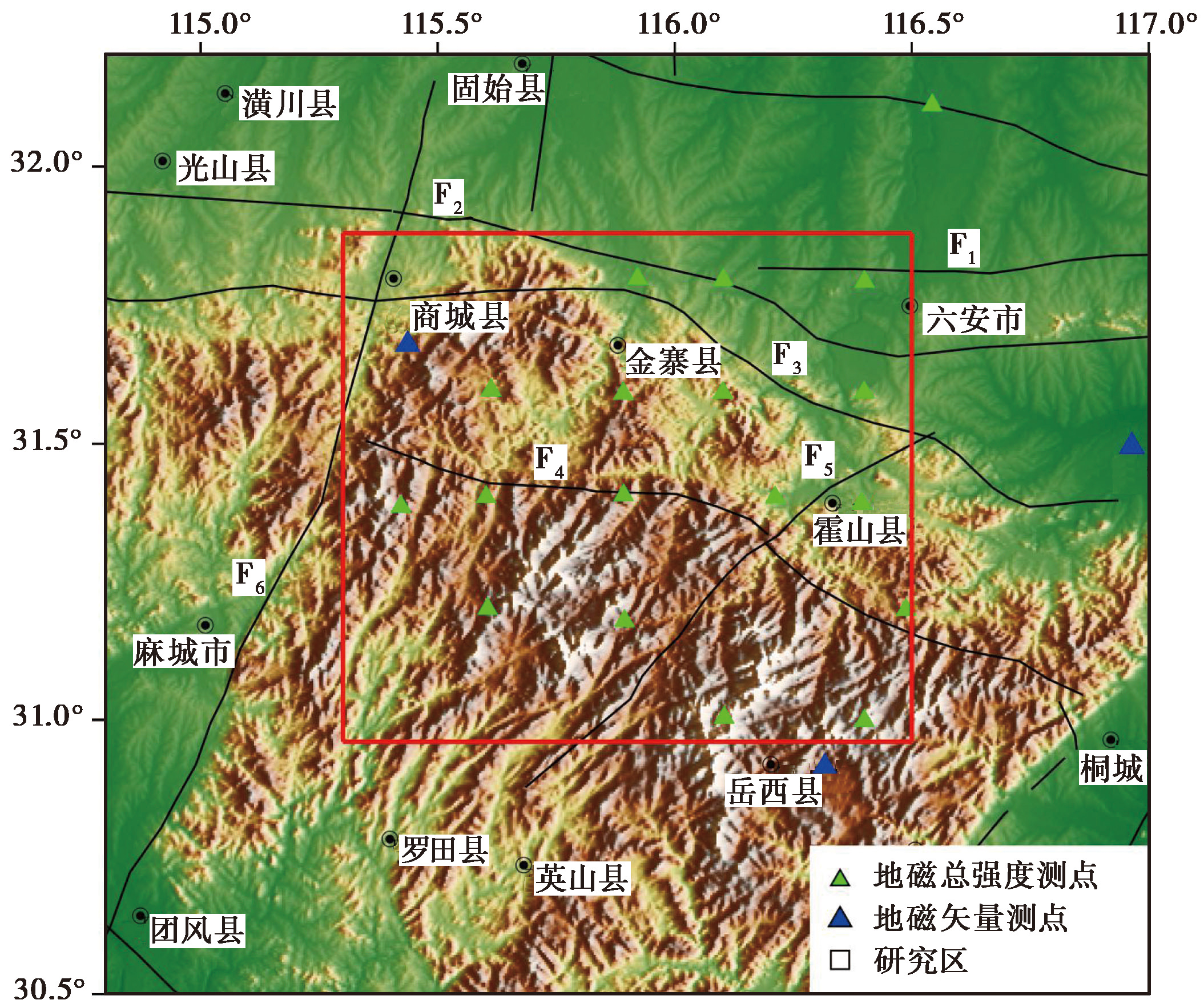
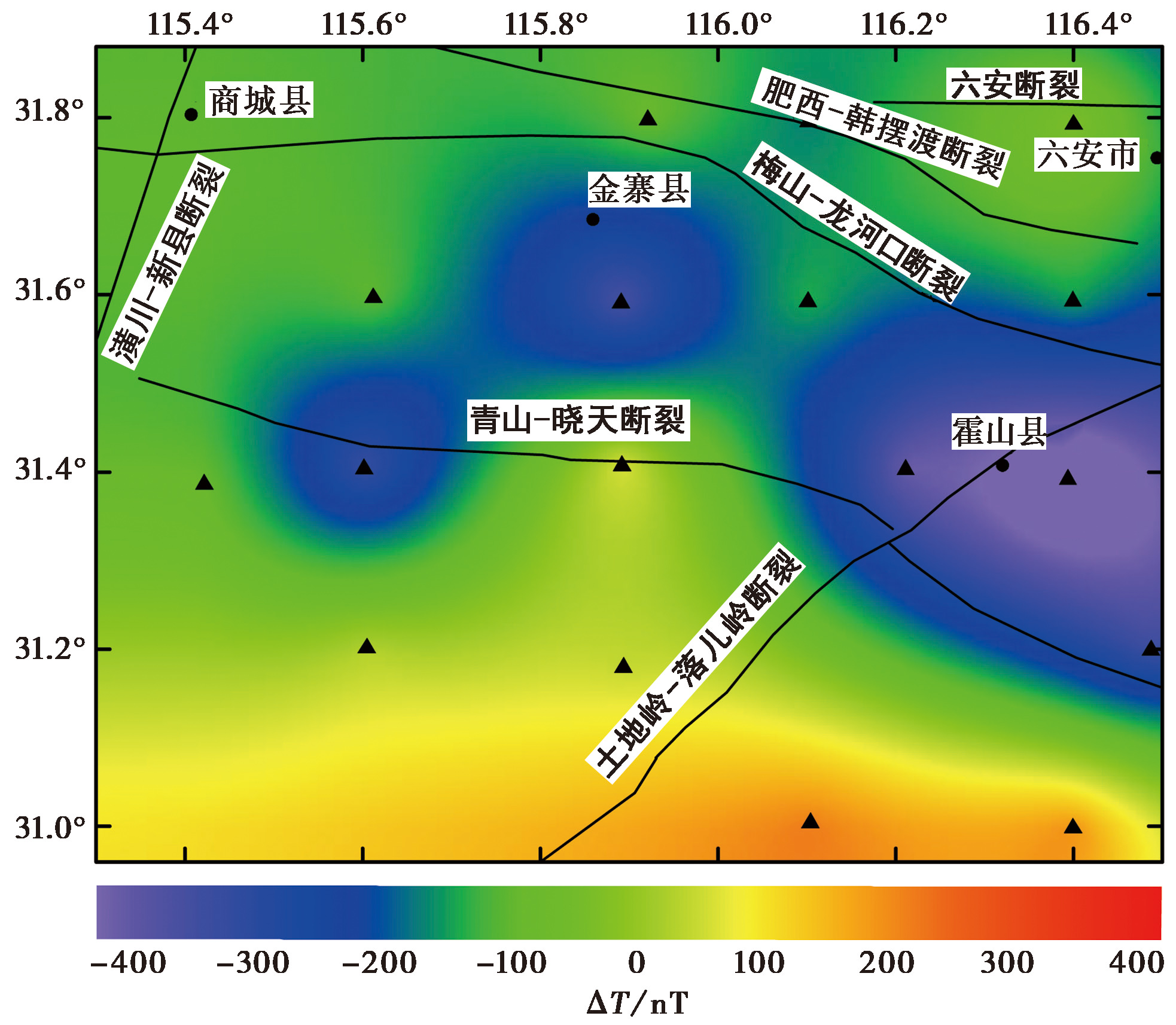
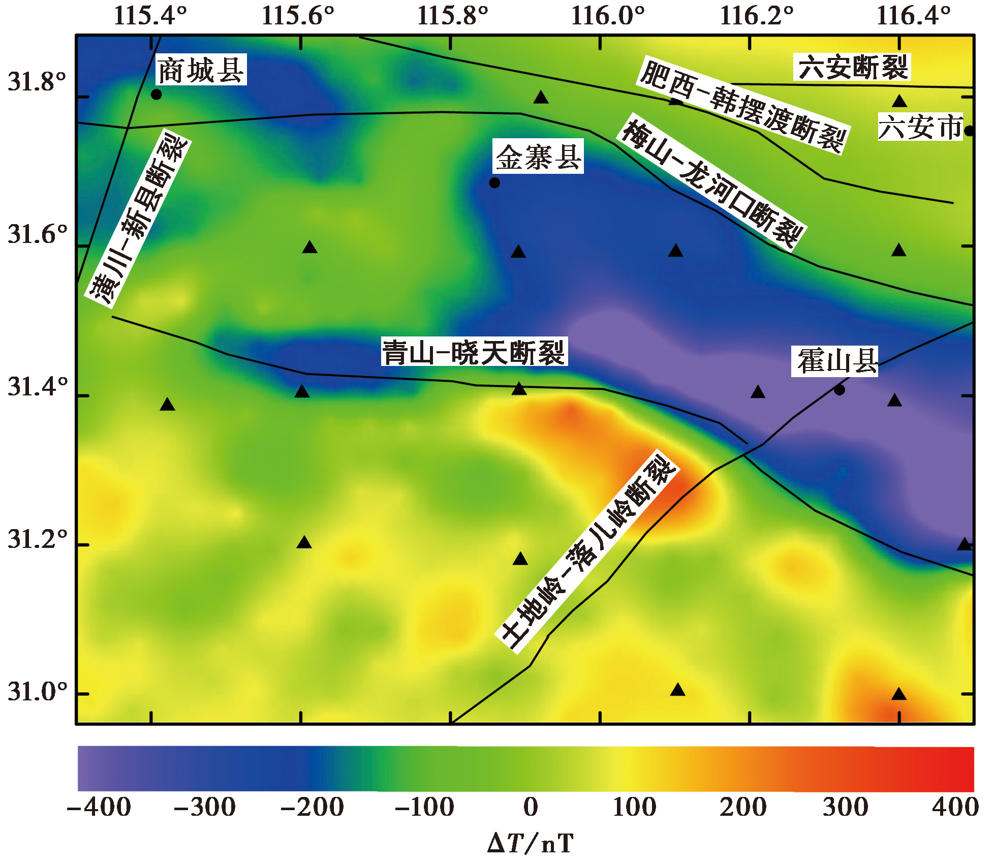
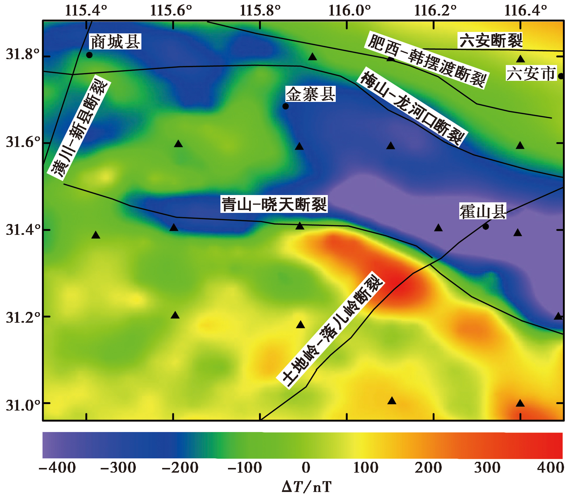
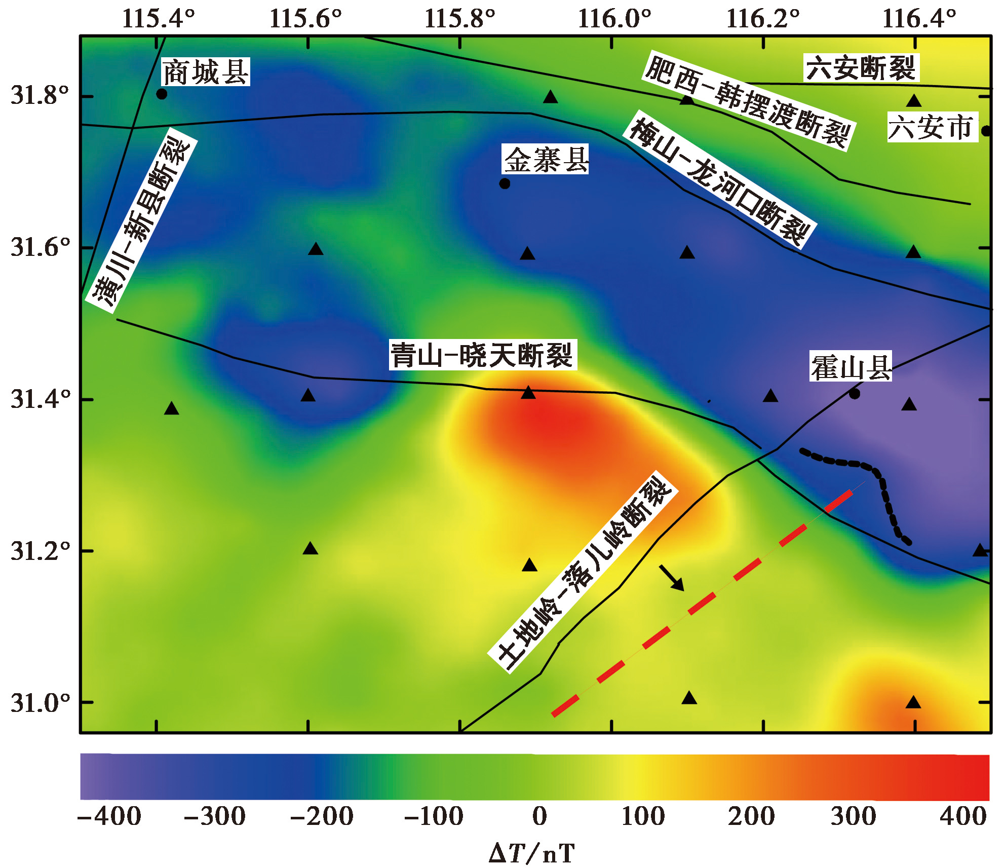
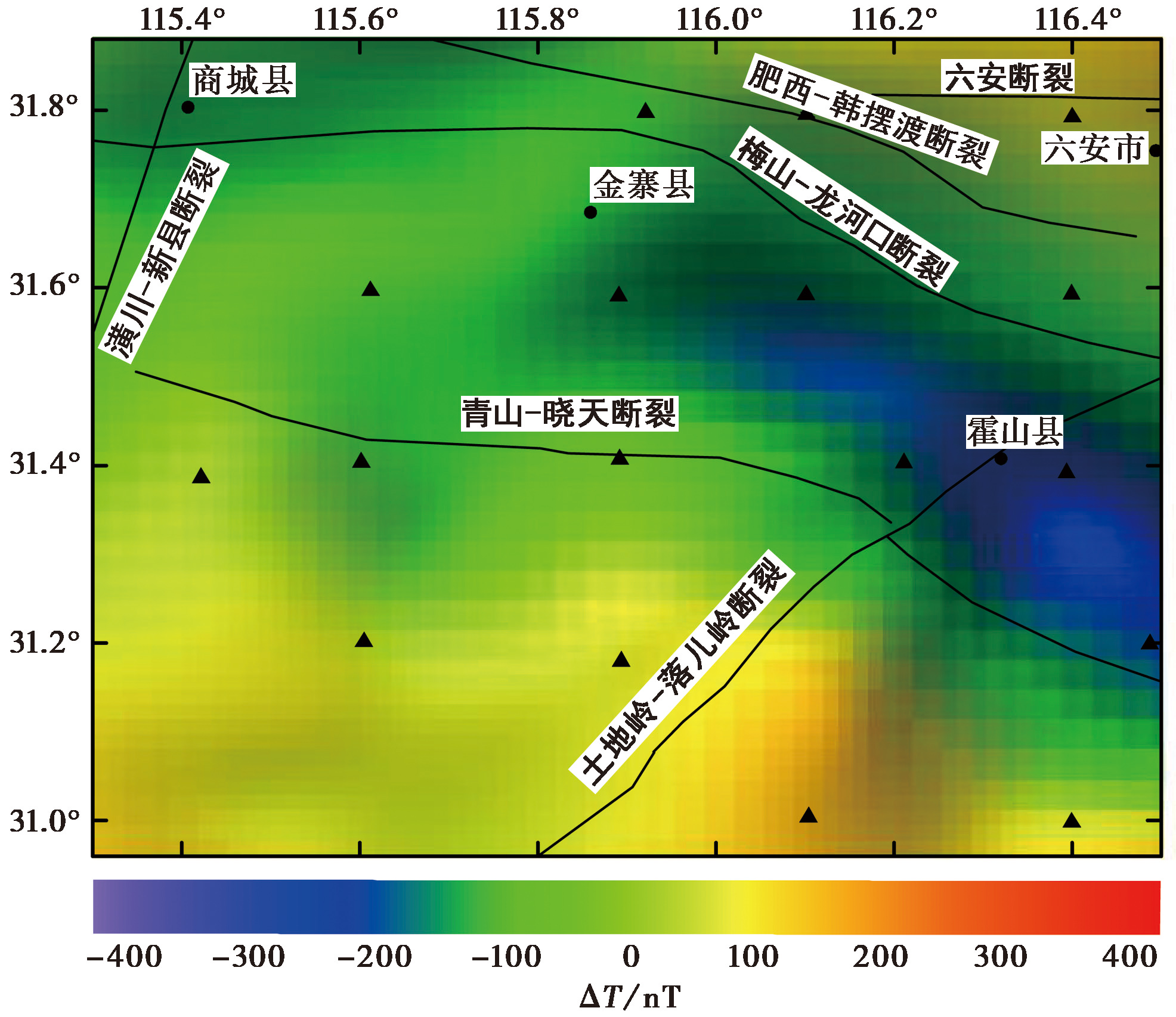
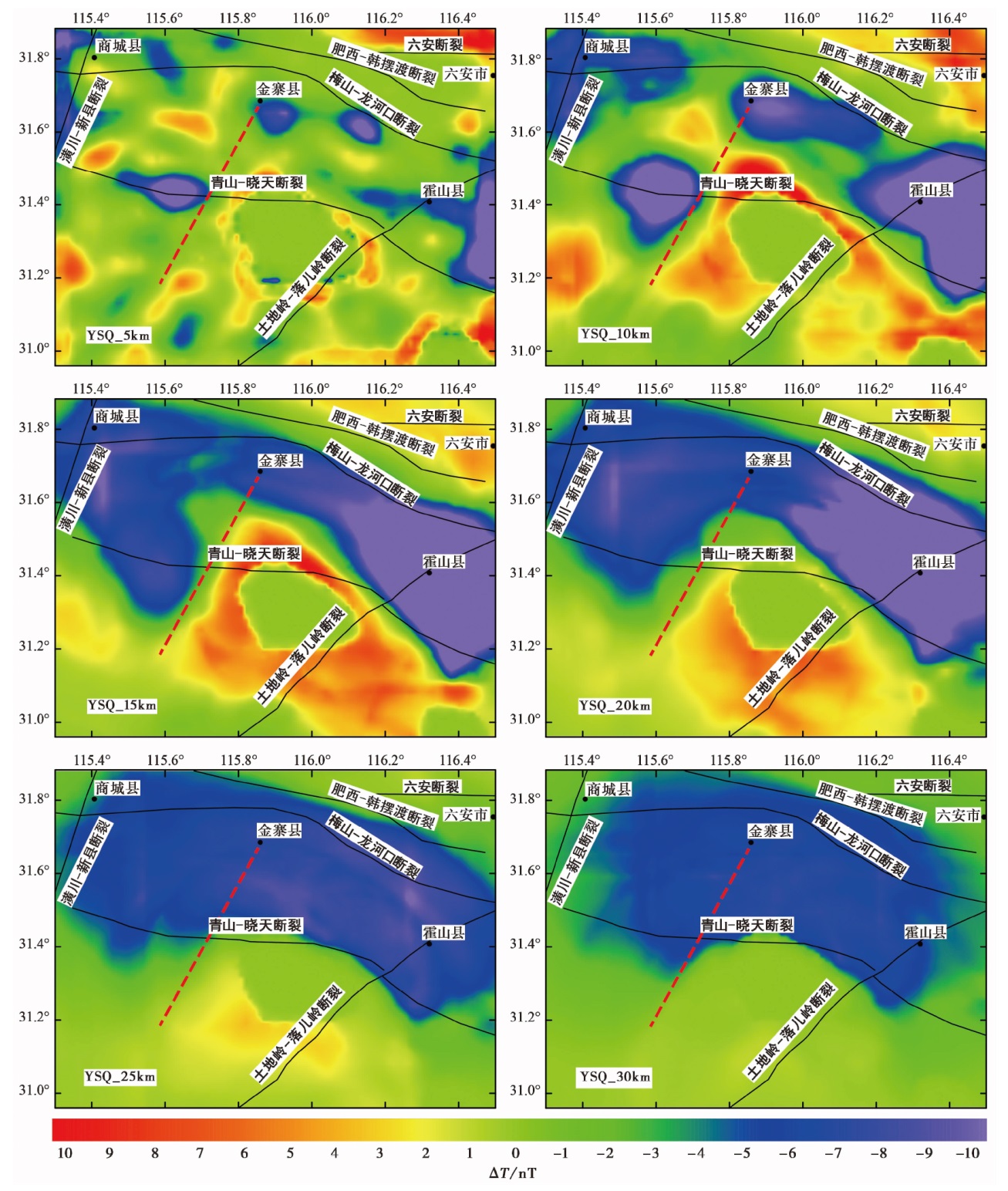
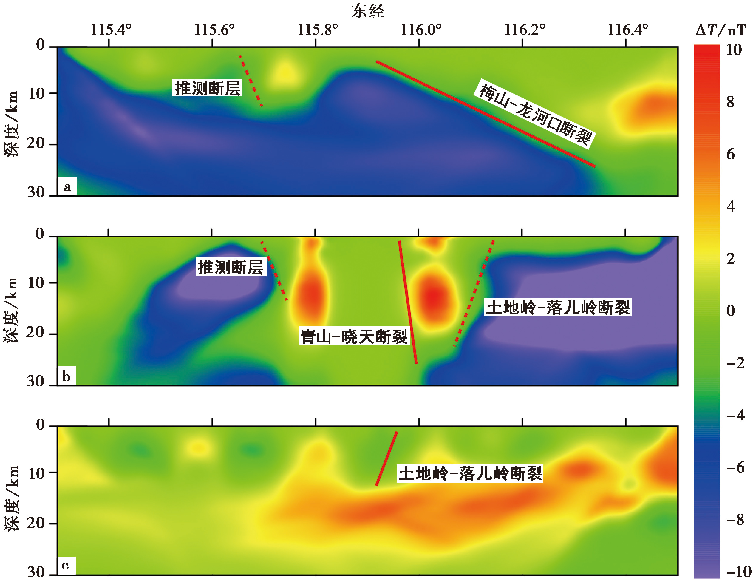
CONSTRUCTION OF THE LITHOSPHERIC MAGNETIC FIELD IN THE EAST DABIE REGION BASED ON MULTIPLE DATA SOURCES AND ANALYSIS OF ITS RELATIONSHIP WITH TECTONICS

CHU Fei1,2,3,4)(), XIAO Wei-peng2,3,4),*(), SUN Hong-bo2,3,4), LIANG Xiao2,3,4), FANG Zhen2,3,4), HUANG Xian-liang2,3,4), SUN Bo-le2), YING Yun-xiang2,3), ZHENG Hai-gang1,2,3,4)   

  1. 1) School of Earth and Space Sciences, University of Science and Technology of China, Hefei 230026, China
    2) Anhui Earthquake Agency, Hefei 230031, China
    3) Anhui Mengcheng National Geophysical Observatory, Mengcheng 233500, China
    4) Anhui Provincial Key Laboratory of Subsurface Exploration and Earthquake Risk Prevention, Hefei 230031, China
  • Received:2025-01-18 Revised:2025-02-14 Online:2026-04-20 Published:2026-05-14
  • Contact: XIAO Wei-peng

基于多源数据融合的东大别地区岩石圈磁场构建及与构造关系分析

储飞1,2,3,4)(), 肖伟鹏2,3,4),*(), 孙鸿博2,3,4), 梁霄2,3,4), 方震2,3,4), 黄显良2,3,4), 孙伯乐2), 应允翔2,3), 郑海刚1,2,3,4)   

  1. 1) 中国科学技术大学, 地球和空间科学学院, 合肥 230026
    2) 安徽省地震局, 合肥 230031
    3) 科技部蒙城地球物理野外观测站, 蒙城 233500
    4) 安徽省地下结构探测与震灾风险防范重点实验室, 合肥 230031
  • 通讯作者: 肖伟鹏
  • 作者简介:

    储飞, 男, 1988年生, 2014年于成都理工大学获地质工程专业硕士学位, 高级工程师, 主要从事地震地磁观测及研究方向, E-mail:

  • 基金资助:
    安徽省科技创新攻坚计划(202423l10050030); 安徽省科技创新攻坚计划(202523t06050002); 中国地震局地震监测、预报、科研三结合项目(3JH-202401029); 中国地震局震情跟踪专项任务(2024010414)

Abstract:

As a vital component of the Earth’s internal magnetic field, the lithospheric magnetic field provides essential information for revealing the material composition, structure, and tectonic evolution of the crust and upper mantle. Constructing high-precision lithospheric magnetic field models and integrating them with geological structural features to analyze how tectonics and strata control the magnetic field is crucial for understanding regional geology and deep structural processes.
To achieve this, we employed the equivalent source method to integrate ground and aeromagnetic survey data from the study area(115.3°-116.5°E, 30.96°-31.88°N). Eighteen ground total field magnetic intensity data were measured in December 2022.Following diurnal and secular variation corrections and stripping off the main magnetic field, we obtained the lithospheric magnetic field, which possesses high absolute accuracy but limited spatial resolution. In contrast, the 5km×5km-resolution aeromagnetic data cover a much broader area but lack fine-scale detail and reflect a smoothed composite magnetic field due to the flight altitude. The equivalent source method effectively reconciled these heterogeneous datasets by calculating an equivalent source layer that could predict both data types, thereby reducing systematic bias and generating a high-fidelity, unified magnetic anomaly map on a consistent datum. Subsequently, using the interpolation-cut method—a potential field separation technique suitable for regional studies—the fused magnetic anomaly field was decomposed into source components from varying depths. This process yielded a series of horizontal slices of the lithospheric magnetic field from the near-surface down to approximately 33km(essentially reaching below the regional Curie isotherm).Such depth dependent separation is critical for distinguishing shallow local magnetic sources from deep regional-scale structures.
The results show that the fused lithospheric magnetic field model exhibits significantly higher resolution and clearer geological interpretation than single datasets or global models such as EMAG3. The model clearly delineates two first-order magnetic anomaly domains: a prominent, broad NNW-SSE trending negative anomaly belt outlining the North Huaiyang fold belt, and a distinct positive anomaly block associated with the North Dabie uplift. These large-scale features are interpreted as reflecting fundamental differences in basement rock magnetism, corresponding to the metasedimentary sequences of the North Huaiyang and the magmatic-metamorphic complexes of the Dabie Block, respectively.
The depth slices obtained via potential field separation provide new insights into three-dimensional structures and the controlling roles of major boundaries. Key findings include: The Qingshan-Xiaotian and Feixi-Hanbaidu faults are clearly identified as the southern and northern boundaries of the North Huaiyang negative anomaly. Their control becomes more pronounced at greater depths(25-30km), confirming their status as major deep-seated faults. The core of the North Huaiyang negative anomaly mainly originates from mid-to-lower crustal depths(15-25km), while the Dabie positive anomaly is strongest within the 15-20km range and attenuates significantly below 25km. The Tudiling-Luo’erling fault exhibits a clear magnetic discontinuity, constraining its cutting depth to roughly 10-15km, suggesting it is a potentially active fault that does not penetrate the lower crust. The Meishan-Longhekou fault influences the upper crust but shows no significant features in the deep(>25km)magnetic structure. Based on linear anomaly features and discontinuity patterns, particularly evident in the 10-20km slices, we infer the presence of a previously unrecognized NNE-trending concealed fault in the northwestern part of the study area, with an estimated cutting depth of 10-15km.
In conclusion, by applying multi-source data fusion, this study establishes a high-precision lithospheric magnetic field model for the Eastern Dabie region. Subsequent multi-scale analysis via potential field separation effectively couples magnetic signals from different depths, providing reliable geophysical evidence for the geometry, depth extension, and tectonic roles of major faults and structural units. This work not only deepens understanding of the deep structure of the Eastern Dabie orogenic belt and provides geometric constraints for tectonic interpretation, but also demonstrates an effective methodological framework for integrated geological-geophysical interpretation in complex terranes.

Key words: East Dabie Orogen, ground magnetic survey, airborne magnetic survey, data fusion, lithospheric magnetic field, potential field separation, tectonic correlation

摘要:

文中基于等效源法融合东大别地区地面磁测数据与航空磁测数据构建高精度岩石圈磁场模型, 以插值切割法对岩石圈磁场进行位场分离, 从而获取不同层位磁场分布, 并结合研究区地质构造分布特征, 分析相关构造及地层对岩石圈磁场的控制作用。结果显示, 融合构建的岩石圈磁场模型精度较高, 较为清晰地刻画出北淮阳褶皱带的巨大负异常条带及大别山隆起因岩浆作用而形成的正异常块体。位场分离结果显示, 区内发育的多条区域性断裂对磁场都有一定的切割和控制作用, 其中从不同深度磁场分布分析认为土地岭-落儿岭断裂的切割深度为10~15km, 北淮阳褶皱带的巨大负异常条带主要来自于15~25km的深部异常, 且青山-晓天断裂和肥西-韩摆渡断裂分别是该构造单元的南、 北界限, 尤其在25km和30km深度处该特征最为明显, 说明这2个断裂均为区域深大断裂。

关键词: 东大别, 地面磁测, 航空磁测, 数据融合, 岩石圈磁场, 位场分离, 构造相关性