
SEISMOLOGY AND GEOLOGY ›› 2026, Vol. 48 ›› Issue (3): 870-891.DOI: 10.3969/j.issn.0253-4967.20240144
• Research paper • Previous Articles Next Articles
PCA-BASED DAMAGED BUILDING CHANGE DETECTION MODEL USING UAV IMAGE TEXTURE FEATURES: CASE STUDIES OF THE 2023 GANSU JISHISHAN MS6.2 AND 2021 YUNNAN YANGBI MS6.4 EARTHQUAKES
DU Hao-guo1,2)( ), ZUO Xiao-qing1),*(), LIN Xu-chuan3), LU Yong-kun2), DU Hao-biao4), CHEN Yong-sheng3), LI Ji-chao3), ZHANG Fang-hao2), HE Shi-fang2), DENG Shu-rong2), ZHAO Zheng-xian2), XU Jun-zu2), BAI Xian-fu2), ZHANG Yuan-shuo2)
- 1)
Faculty of Land Resources Engineering ,Kunming University of Science and Technology
2)Yunnan Earthquake Agency
3)Institute of Engineering Mechanics ,CEA
4)Army Engineering University of PLA
-
Received:2025-01-27Revised:2025-03-31Online:2026-06-20Published:2026-07-09
基于无人机影像纹理特征PCA破坏建筑物变化检测模型——以2023年甘肃积石山MS6.2和2021年云南漾濞MS6.4地震为例
杜浩国1,2)(), 左小清1),*(), 林旭川3), 卢永坤2), 杜浩标4), 陈永盛3), 李吉超3), 张方浩2), 和仕芳2), 邓树荣2), 赵正贤2), 徐俊祖2), 白仙富2), 张原硕2)
- 1)
昆明理工大学 ,国土资源工程学院
2)云南省地震局
3)中国地震局工程力学研究所
4)中国人民解放军陆军工程大学
-
通讯作者:*左小清, 男, 1972年生, 博士, 教授, 主要从事雷达干涉测量与地质灾害监测、识别, E-mail: zxq@kust.edu.cn。 -
作者简介:杜浩国, 男, 1991年生, 现为昆明理工大学资源与环境专业在读博士研究生, 高级工程师, 主要从事震后影像建筑物破坏识别、地震灾害损失评估研究, E-mail: 1364125834@qq.com。
-
基金资助:中国地震局地震科技星火计划项目(XH23035YB); 云南省基础研究专项(202501CI070026); 云南省地震局科技创新团队——地震灾害情景构建(CXTD202409)

Cite this article
DU Hao-guo, ZUO Xiao-qing, LIN Xu-chuan, LU Yong-kun, DU Hao-biao, CHEN Yong-sheng, LI Ji-chao, ZHANG Fang-hao, HE Shi-fang, DENG Shu-rong, ZHAO Zheng-xian, XU Jun-zu, BAI Xian-fu, ZHANG Yuan-shuo. PCA-BASED DAMAGED BUILDING CHANGE DETECTION MODEL USING UAV IMAGE TEXTURE FEATURES: CASE STUDIES OF THE 2023 GANSU JISHISHAN MS6.2 AND 2021 YUNNAN YANGBI MS6.4 EARTHQUAKES[J]. SEISMOLOGY AND GEOLOGY, 2026, 48(3): 870-891.
杜浩国, 左小清, 林旭川, 卢永坤, 杜浩标, 陈永盛, 李吉超, 张方浩, 和仕芳, 邓树荣, 赵正贤, 徐俊祖, 白仙富, 张原硕. 基于无人机影像纹理特征PCA破坏建筑物变化检测模型——以2023年甘肃积石山MS6.2和2021年云南漾濞MS6.4地震为例[J]. 地震地质, 2026, 48(3): 870-891.
share this article
Add to citation manager EndNote|Ris|BibTeX
URL: https://www.dzdz.ac.cn/EN/10.3969/j.issn.0253-4967.20240144
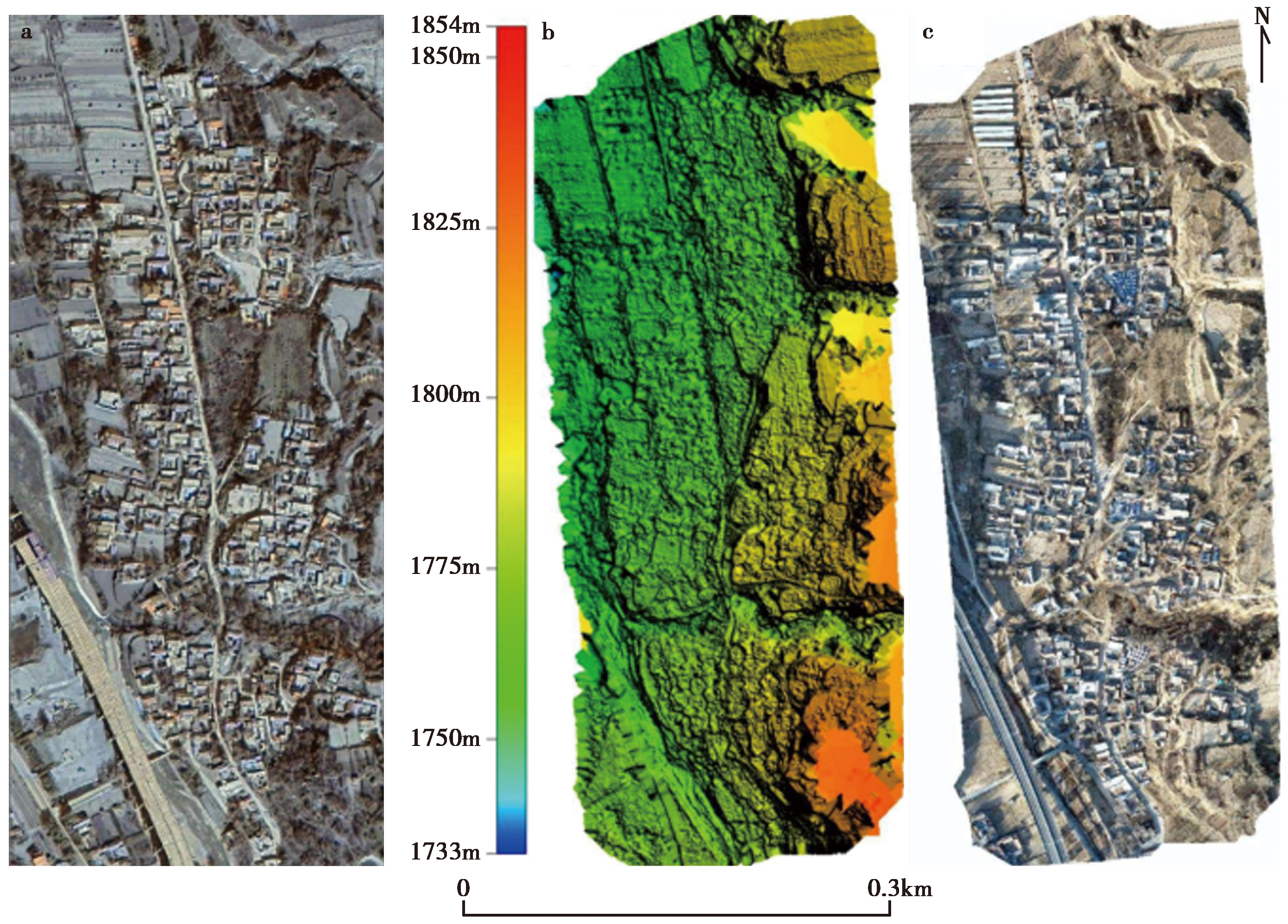
Fig. 1 Image data of the study area.
| 数据源 | 类型 | 日期 | 大小 /MB | 面积 /m2 | 分辨率 /m | 宽度 /像素 | 高度 /像素 | 格式 | 波段 数量 | 投影坐标系 | |
|---|---|---|---|---|---|---|---|---|---|---|---|
| a | QuickBird | DOM | 2022-04-28 | 222 | 620000 | 0.105 | 6786 | 8350 | TIFF | 4 | WGS_1984_UTM_Zone_48N |
| b | UAV | DSM | 2023-12-18 | 170 | 620000 | 0.107 | 5006 | 10833 | TIFF | 1 | WGS_1984_UTM_Zone_48N |
| c | UAV | DOM | 2023-12-18 | 329 | 620000 | 0.053 | 10105 | 21869 | TIFF | 4 | WGS_1984_UTM_Zone_48N |
Table1 The DSM data and image information of study area
| 数据源 | 类型 | 日期 | 大小 /MB | 面积 /m2 | 分辨率 /m | 宽度 /像素 | 高度 /像素 | 格式 | 波段 数量 | 投影坐标系 | |
|---|---|---|---|---|---|---|---|---|---|---|---|
| a | QuickBird | DOM | 2022-04-28 | 222 | 620000 | 0.105 | 6786 | 8350 | TIFF | 4 | WGS_1984_UTM_Zone_48N |
| b | UAV | DSM | 2023-12-18 | 170 | 620000 | 0.107 | 5006 | 10833 | TIFF | 1 | WGS_1984_UTM_Zone_48N |
| c | UAV | DOM | 2023-12-18 | 329 | 620000 | 0.053 | 10105 | 21869 | TIFF | 4 | WGS_1984_UTM_Zone_48N |
| 飞机性能Phantom4Pro | 技术参数飞行架次 | 飞机性能4架次 | 技术参数型号 |
|---|---|---|---|
| 总质量 | 1375g | 航线重叠率 | 70% |
| 飞行高度 | 200m | 旁向重叠率 | 65% |
| 飞行时长 | ≤27min | 总成像面积 | 0.62km2 |
| 悬停精度 | 垂直方向±0.1m 水平方向±0.1m | 影像格式 | TIFF(DOM) TIFF(DSM) |
| 倾角 | -88° | 航拍照片数量 | 918张 |
| 飞行速度 | ≥20km/h | 单色传感器增益 | 1~8倍 |
| 影像传感器 | 1英寸 CMOS 2000万像素 | 镜头 | FOV 84°8.8mm/24mm f/2.8-f/11 自动对焦 |
Table2 The UAV equipment parameters
| 飞机性能Phantom4Pro | 技术参数飞行架次 | 飞机性能4架次 | 技术参数型号 |
|---|---|---|---|
| 总质量 | 1375g | 航线重叠率 | 70% |
| 飞行高度 | 200m | 旁向重叠率 | 65% |
| 飞行时长 | ≤27min | 总成像面积 | 0.62km2 |
| 悬停精度 | 垂直方向±0.1m 水平方向±0.1m | 影像格式 | TIFF(DOM) TIFF(DSM) |
| 倾角 | -88° | 航拍照片数量 | 918张 |
| 飞行速度 | ≥20km/h | 单色传感器增益 | 1~8倍 |
| 影像传感器 | 1英寸 CMOS 2000万像素 | 镜头 | FOV 84°8.8mm/24mm f/2.8-f/11 自动对焦 |
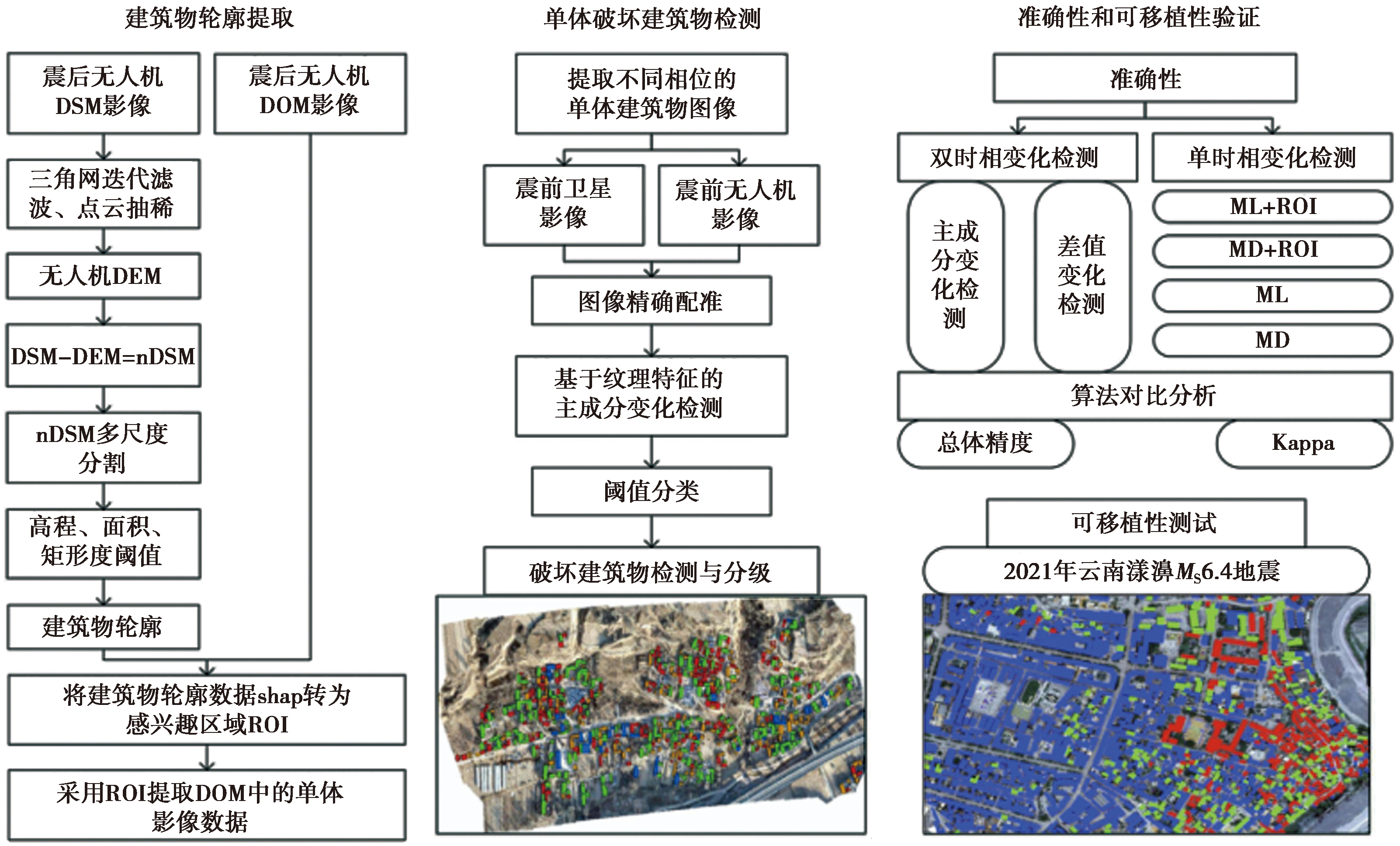
Fig. 2 Model flowchart.
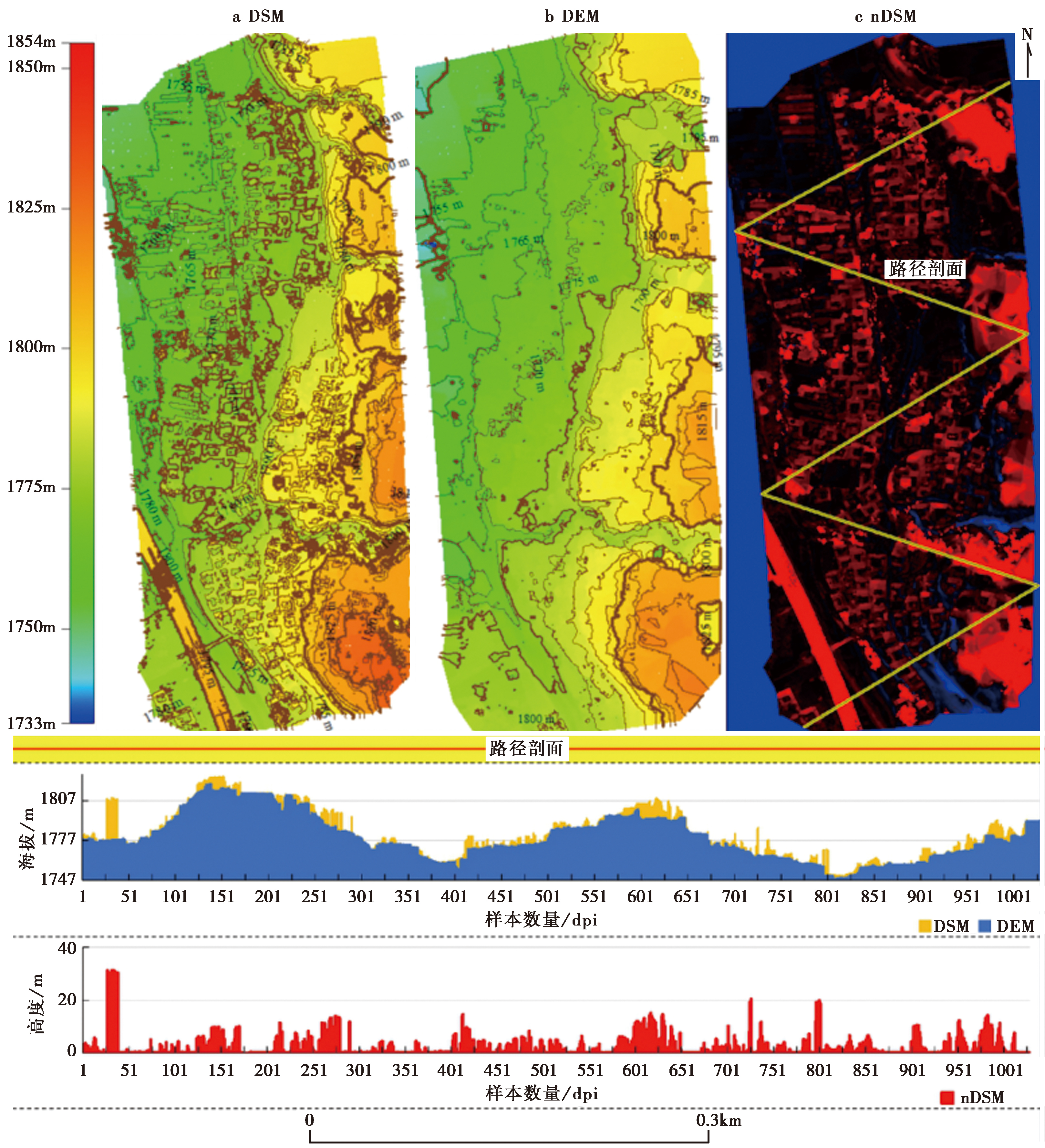
Fig. 3 The solution results of nDSM and the results from DSM, DEM and nDSM elevation profiles.
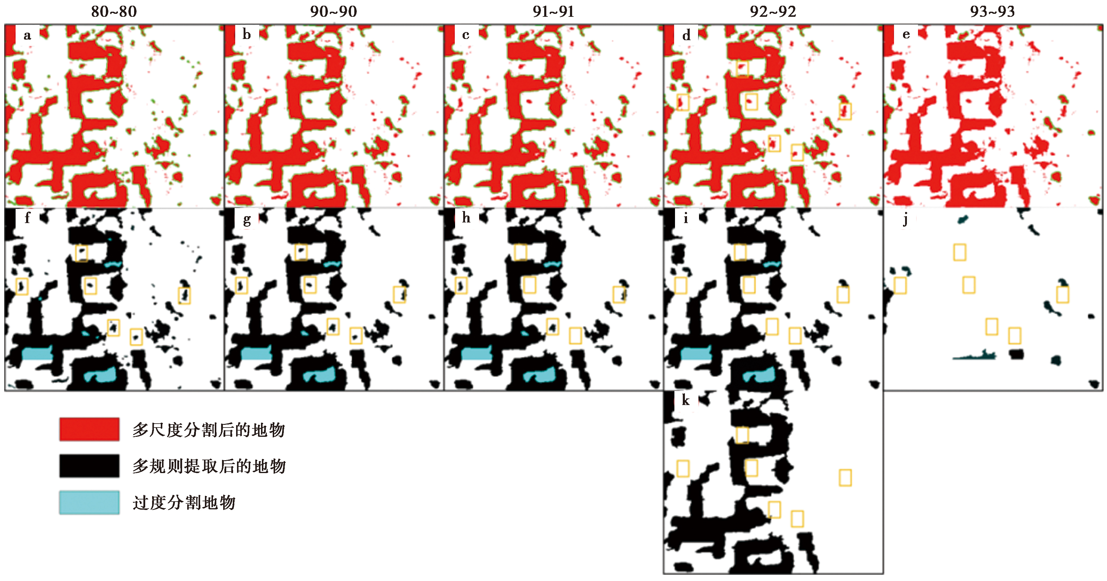
Fig. 4 The results of different segmentation and merging scales.
| 公式 | 参数设置 | 操作步骤 | 产出结果 |
|---|---|---|---|
| (1) | DSM分辨率: 0.105m; DEM分辨率: 0.107m(通过点云抽稀生成); 高程阈值: ≥2.5m(滤除非建筑物)。 | ①通过无人机影像生成DSM; ②点云抽稀与三角网迭代滤波分离地面点生成DEM; ③配准DSM与DEM, 统一分辨率; ④逐像元计算差值生成nDSM; ⑤设定高程阈值(≥2.5m)过滤植被和围墙。 | 归一化数字表面模型(nDSM); 突出建筑物高度信息( |
| (2) | 波段数: B=4(R、G、B、NIR); 灰度范围: 0~255; 影像分辨率: 0.053m(震后DOM)。 | ①对每个像元在4个波段(R、G、B、NIR)上读取灰度值; ②计算4个波段的平均灰度值; ③输出光谱平均值影像。 | 每个像元的光谱平均值(用于消除单波段噪声), 如震后影像中建筑物平均灰度值范围150~255。 |
| (3) | 像元面积: mpixel=0.002 809m2; 面积阈值: 500m2<S<150 000m2; | ①统计分割后的地物对象占用的像元总数N; ②根据影像分辨率计算单个像元面积; ③计算真实面积S; ④应用面积阈值过滤非目标地物(如碎片)。 | 地物对象的实际面积(m2), 用于优化建筑物轮廓分类。 |
| (4) | 矩形度阈值: 0.6<Rect<1( 分割合并尺度: 92(最优分割尺度)。 | ①计算分割像元的真实面积S; ②提取分割像元的最小外接矩形长轴Rmax和短轴Rmin; ③计算矩形度并应用阈值(0.6~1)优化分类。 | 矩形度值(0.6~1),用于筛选规则建筑物轮廓( |
Table3 Parameter setting, operation step and output result by using formula(1)—(4)
| 公式 | 参数设置 | 操作步骤 | 产出结果 |
|---|---|---|---|
| (1) | DSM分辨率: 0.105m; DEM分辨率: 0.107m(通过点云抽稀生成); 高程阈值: ≥2.5m(滤除非建筑物)。 | ①通过无人机影像生成DSM; ②点云抽稀与三角网迭代滤波分离地面点生成DEM; ③配准DSM与DEM, 统一分辨率; ④逐像元计算差值生成nDSM; ⑤设定高程阈值(≥2.5m)过滤植被和围墙。 | 归一化数字表面模型(nDSM); 突出建筑物高度信息( |
| (2) | 波段数: B=4(R、G、B、NIR); 灰度范围: 0~255; 影像分辨率: 0.053m(震后DOM)。 | ①对每个像元在4个波段(R、G、B、NIR)上读取灰度值; ②计算4个波段的平均灰度值; ③输出光谱平均值影像。 | 每个像元的光谱平均值(用于消除单波段噪声), 如震后影像中建筑物平均灰度值范围150~255。 |
| (3) | 像元面积: mpixel=0.002 809m2; 面积阈值: 500m2<S<150 000m2; | ①统计分割后的地物对象占用的像元总数N; ②根据影像分辨率计算单个像元面积; ③计算真实面积S; ④应用面积阈值过滤非目标地物(如碎片)。 | 地物对象的实际面积(m2), 用于优化建筑物轮廓分类。 |
| (4) | 矩形度阈值: 0.6<Rect<1( 分割合并尺度: 92(最优分割尺度)。 | ①计算分割像元的真实面积S; ②提取分割像元的最小外接矩形长轴Rmax和短轴Rmin; ③计算矩形度并应用阈值(0.6~1)优化分类。 | 矩形度值(0.6~1),用于筛选规则建筑物轮廓( |
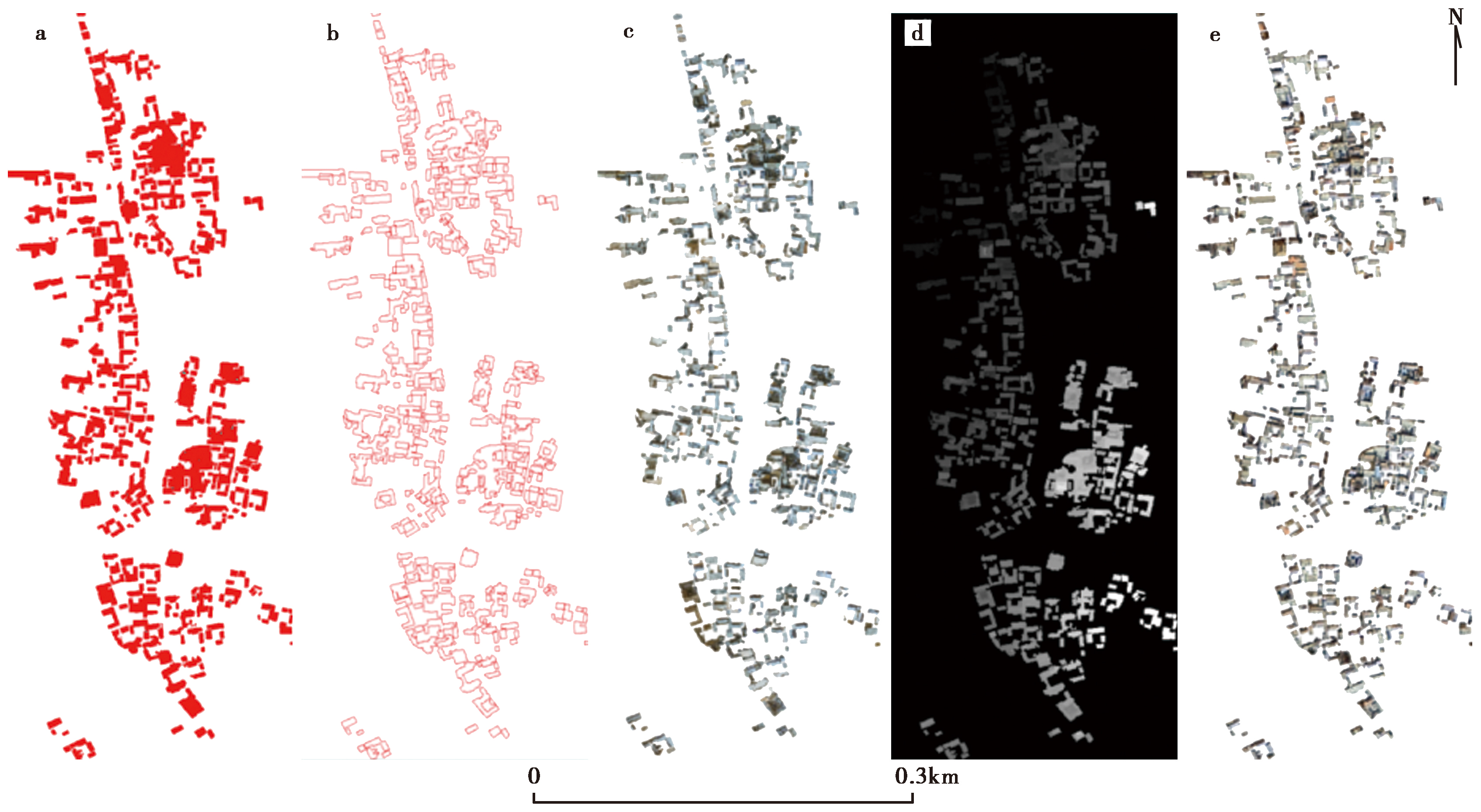
Fig. 5 Building outline extraction.
| 公式。 | 参数设置 | 操作步骤 | 产出结果 |
|---|---|---|---|
| (5) | 输入影像: 震前QuickBird卫星影像(分辨率0.72m); 目标分辨率: 0.053m(与无人机DOM一致); 邻近像元: 4个 | ①将低分辨率卫星影像分割为0.053m的网格; ②对每个目标像元, 选取原始影像中邻近的4个像元; ③根据距离计算归一化权重wij; ④加权求和生成高分辨率影像。 | 分辨率提升后的卫星影像(与无人机DOM匹配), 用于后续配准( |
| (6)、(7) | 控制点数目: 212个; 搜索窗口大小: 255像素; 最大允许误差: 5像素; 多项式阶数: 2阶。 | ①在震前、震后影像中手动选取212个同名控制点; ②使用最小二乘法拟合二阶多项式模型; ③应用模型校正影像几何形变; ④验证误差(RMS<1像素)。 | 初步配准的影像, 消除几何形变( |
| (8) | 窗口尺寸: W×H=255×255像素; 匹配度阈值: NCC≥0.75; 最大允许误差: 5像素。 | ①使用SIFT算法检测震前、震后影像的特征点; ②在255×255窗口内计算NCC值; ③筛选NCC≥0.75的匹配点; ④剔除容差>5像素的异常点。 | 高精度同名点对(212个有效点), 用于精确配准( |
| (9) | 有效连接点数量: G=212; 坐标偏差: Δxk, Δyk。 | ①计算所有同名点的坐标偏差Δxk, Δyk; ②求取偏差平方和的均值; ③开根号得到RMS值。 | RMS误差=0.8像素(满足精度要求),验证配准可靠性。 |
Table4 Parameter setting, operation step and output result by using formula(5)—(9)
| 公式。 | 参数设置 | 操作步骤 | 产出结果 |
|---|---|---|---|
| (5) | 输入影像: 震前QuickBird卫星影像(分辨率0.72m); 目标分辨率: 0.053m(与无人机DOM一致); 邻近像元: 4个 | ①将低分辨率卫星影像分割为0.053m的网格; ②对每个目标像元, 选取原始影像中邻近的4个像元; ③根据距离计算归一化权重wij; ④加权求和生成高分辨率影像。 | 分辨率提升后的卫星影像(与无人机DOM匹配), 用于后续配准( |
| (6)、(7) | 控制点数目: 212个; 搜索窗口大小: 255像素; 最大允许误差: 5像素; 多项式阶数: 2阶。 | ①在震前、震后影像中手动选取212个同名控制点; ②使用最小二乘法拟合二阶多项式模型; ③应用模型校正影像几何形变; ④验证误差(RMS<1像素)。 | 初步配准的影像, 消除几何形变( |
| (8) | 窗口尺寸: W×H=255×255像素; 匹配度阈值: NCC≥0.75; 最大允许误差: 5像素。 | ①使用SIFT算法检测震前、震后影像的特征点; ②在255×255窗口内计算NCC值; ③筛选NCC≥0.75的匹配点; ④剔除容差>5像素的异常点。 | 高精度同名点对(212个有效点), 用于精确配准( |
| (9) | 有效连接点数量: G=212; 坐标偏差: Δxk, Δyk。 | ①计算所有同名点的坐标偏差Δxk, Δyk; ②求取偏差平方和的均值; ③开根号得到RMS值。 | RMS误差=0.8像素(满足精度要求),验证配准可靠性。 |
| 建筑物 结构类型 | 倒塌 类型 | 影像特征 | |||||||||||
|---|---|---|---|---|---|---|---|---|---|---|---|---|---|
| 废墟堆积 | 色调差异 | 轮廓规则性 | 阴影特征 | 纹理变化 | |||||||||
| 土木 结构 | 部分倒塌 | 大量废墟堆积,纹理不均匀 | 震前、震后色调差异明显,倒塌区域色调较深且不均匀 | 轮廓模糊或不完整,难以辨认原始结构 | 无明显建筑物阴影 | 纹理不均匀,震前、震后纹理差异显著 | |||||||
| 砖木 结构 | 局部 倒塌 | 大块废墟堆积,分布较集中 | 倒塌区域色调较浅,整体色调较均匀 | 轮廓不规则,但仍能辨认部分结构 | 无明显建筑物阴影 | 纹理较均匀,倒塌区域纹理变化明显 | |||||||
| 砖混 结构 | 局部 倒塌 | 少量废墟堆积,分布较分散 | 色调变化轻微,倒塌区域与未倒塌区域色调差异较小 | 轮廓清晰,形状规则,倒塌部分轮廓仍较完整 | 可能有部分阴影,但整体阴影较完整 | 纹理变化轻微,屋顶部分纹理可能发生变化 | |||||||
| 建筑物 结构类型 | 倒塌 类型 | 统计分析特征值 | 区分方法 | ||||||||||
| 纹理复杂度 | 色调标准差 | 轮廓规则性 | 影像目视 | 特征值统计分析 | |||||||||
| 土木 结构 | 部分 倒塌 | 高(废墟堆积导致纹理复杂) | 高(色调差异显著) | 低(轮廓模糊) | 指数废墟堆积明显,色调差异大,轮廓模糊 | 解译纹理复杂度高,色调标准差高,轮廓规则性低 | |||||||
| 砖木 结构 | 局部 倒塌 | 中(大块废墟导致局部纹理复杂) | 中(色调差异较明显) | 中(轮廓不规则) | 大块废墟,色调较浅,轮廓不规则 | 纹理复杂度中,色调标准差中,轮廓规则性中 | |||||||
| 砖混 结构 | 局部 倒塌 | 低(少量废墟导致纹理变化较小) | 低(色调差异较小) | 高(轮廓清晰) | 少量废墟,色调变化小,轮廓清晰 | 纹理复杂度低,色调标准差低,轮廓规则性高 | |||||||
Table5 Image interpretation information of civil, brick-wood and brick-concrete structures during MS6.2 earthquake in Jishishan, Gansu Province
| 建筑物 结构类型 | 倒塌 类型 | 影像特征 | |||||||||||
|---|---|---|---|---|---|---|---|---|---|---|---|---|---|
| 废墟堆积 | 色调差异 | 轮廓规则性 | 阴影特征 | 纹理变化 | |||||||||
| 土木 结构 | 部分倒塌 | 大量废墟堆积,纹理不均匀 | 震前、震后色调差异明显,倒塌区域色调较深且不均匀 | 轮廓模糊或不完整,难以辨认原始结构 | 无明显建筑物阴影 | 纹理不均匀,震前、震后纹理差异显著 | |||||||
| 砖木 结构 | 局部 倒塌 | 大块废墟堆积,分布较集中 | 倒塌区域色调较浅,整体色调较均匀 | 轮廓不规则,但仍能辨认部分结构 | 无明显建筑物阴影 | 纹理较均匀,倒塌区域纹理变化明显 | |||||||
| 砖混 结构 | 局部 倒塌 | 少量废墟堆积,分布较分散 | 色调变化轻微,倒塌区域与未倒塌区域色调差异较小 | 轮廓清晰,形状规则,倒塌部分轮廓仍较完整 | 可能有部分阴影,但整体阴影较完整 | 纹理变化轻微,屋顶部分纹理可能发生变化 | |||||||
| 建筑物 结构类型 | 倒塌 类型 | 统计分析特征值 | 区分方法 | ||||||||||
| 纹理复杂度 | 色调标准差 | 轮廓规则性 | 影像目视 | 特征值统计分析 | |||||||||
| 土木 结构 | 部分 倒塌 | 高(废墟堆积导致纹理复杂) | 高(色调差异显著) | 低(轮廓模糊) | 指数废墟堆积明显,色调差异大,轮廓模糊 | 解译纹理复杂度高,色调标准差高,轮廓规则性低 | |||||||
| 砖木 结构 | 局部 倒塌 | 中(大块废墟导致局部纹理复杂) | 中(色调差异较明显) | 中(轮廓不规则) | 大块废墟,色调较浅,轮廓不规则 | 纹理复杂度中,色调标准差中,轮廓规则性中 | |||||||
| 砖混 结构 | 局部 倒塌 | 低(少量废墟导致纹理变化较小) | 低(色调差异较小) | 高(轮廓清晰) | 少量废墟,色调变化小,轮廓清晰 | 纹理复杂度低,色调标准差低,轮廓规则性高 | |||||||
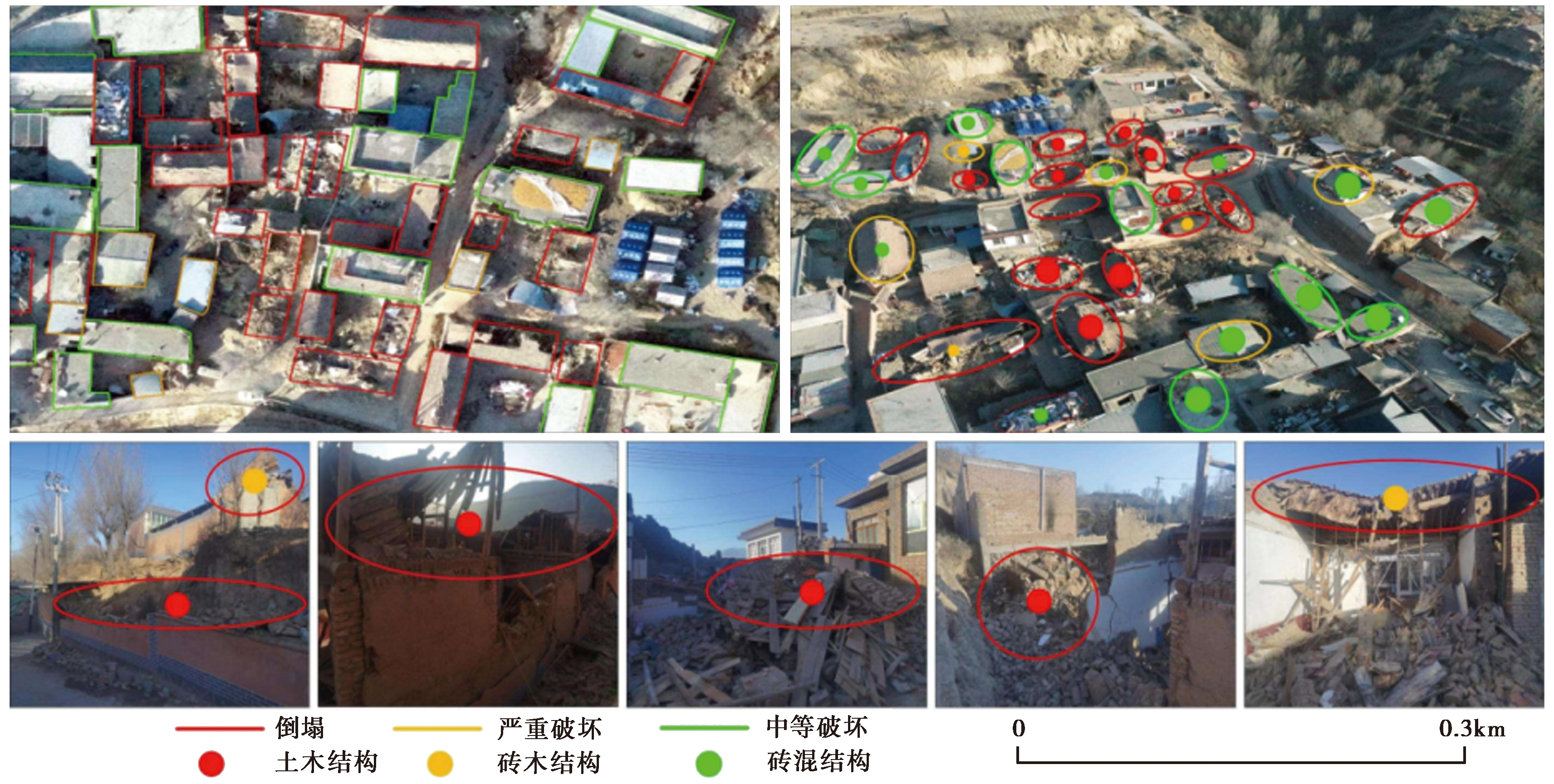
Fig. 6 Post-earthquake field survey image, UAV orthophoto image and UAV oblique image.
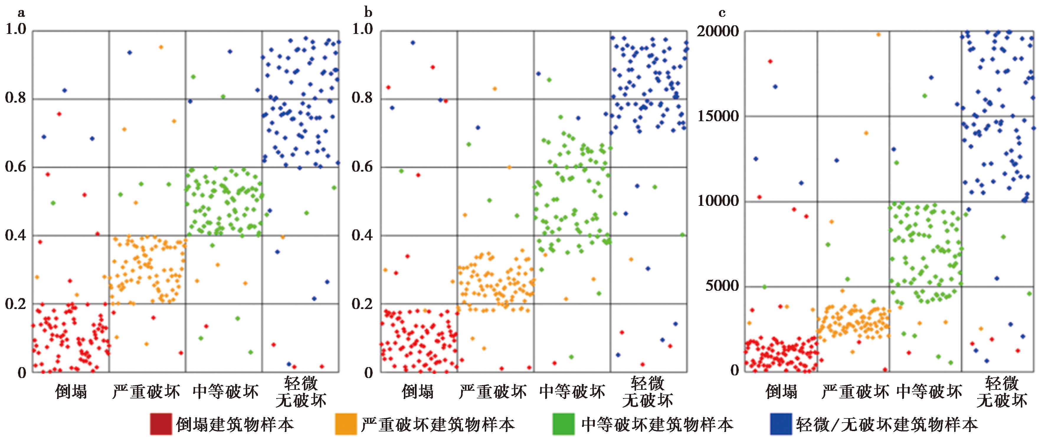
Fig. 7 Statistical distribution of sample threshold.
| 方法 | 倒塌 | 严重破坏 | 中等破坏 | 轻微(或无破坏) |
|---|---|---|---|---|
| 单体+纹理+主成分 | [0,0.2) | [0.2,0.4) | [0.4,0.6) | ≥0.6 |
| 单体+纹理+差值 | [0,0.18) | [0.18,0.35) | [0.35,0.7) | ≥0.7 |
| 单体+差值 | [0,2000) | [2000,4000) | [4000,10000) | ≥10000 |
Table6 The values of threshold classification for buildings with different earthquake damage degree
| 方法 | 倒塌 | 严重破坏 | 中等破坏 | 轻微(或无破坏) |
|---|---|---|---|---|
| 单体+纹理+主成分 | [0,0.2) | [0.2,0.4) | [0.4,0.6) | ≥0.6 |
| 单体+纹理+差值 | [0,0.18) | [0.18,0.35) | [0.35,0.7) | ≥0.7 |
| 单体+差值 | [0,2000) | [2000,4000) | [4000,10000) | ≥10000 |
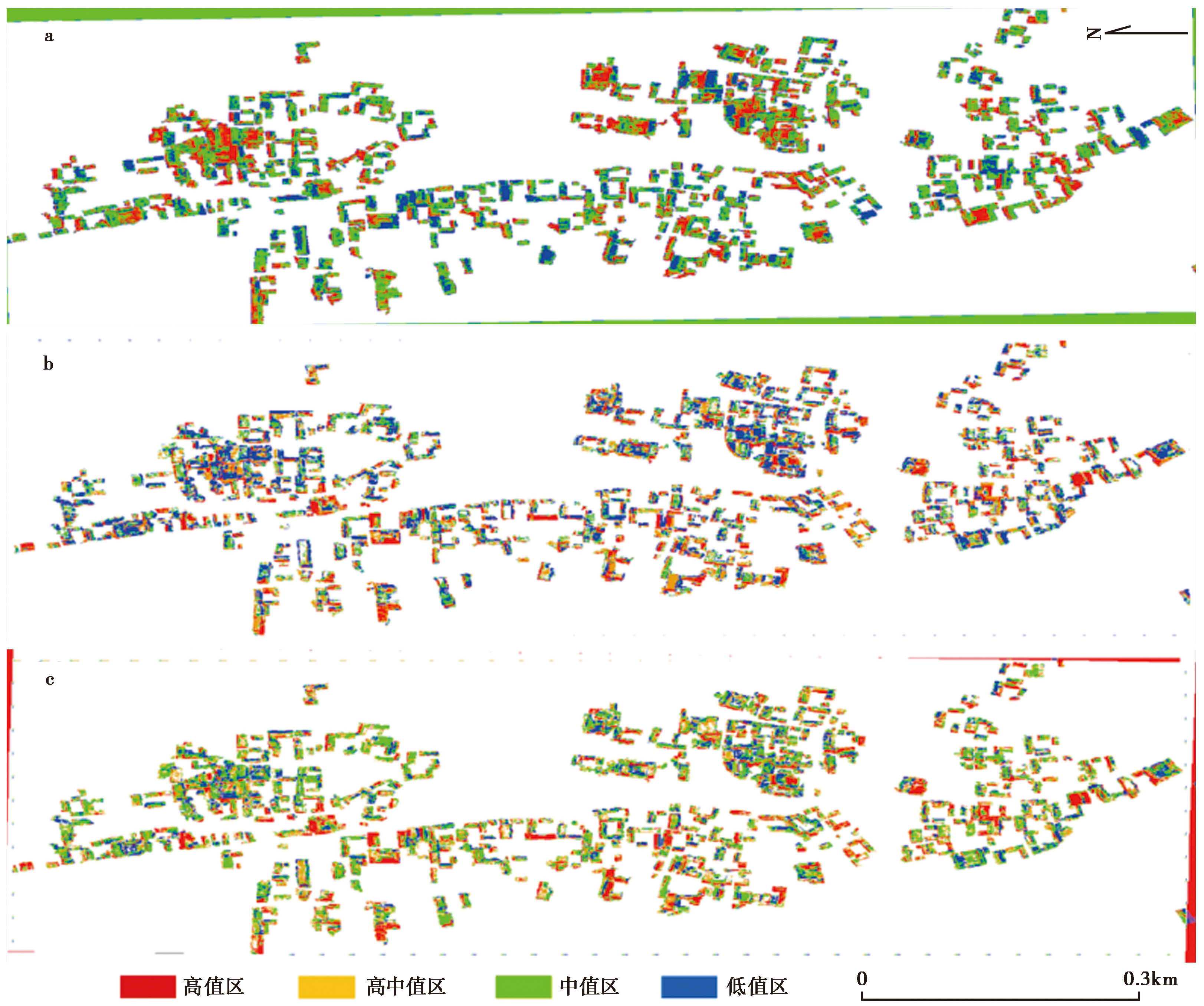
Fig. 8 The extraction results of damaged buildings with different models.
| 破坏 类型 | ||||||||||
|---|---|---|---|---|---|---|---|---|---|---|
| 高值区像素 占比(红色) | 高中值区像素 占比(黄色) | 中值区像素 占比(绿色) | 低值区像素 占比(蓝色) | 像素值 | 破坏特征 | |||||
| if (红色>15%) | if (黄色>0%) | if (绿色>0%) | if (蓝色>0%) | 倒塌 | 151.25<AvgBand 1 <242 | 从正射影像中可以看到废墟堆积、纹理不均匀及明显的震前、震后影像色调差异。 | ||||
| if (红色≤15%) | if (黄色>30%) | if (绿色>0%) | if (蓝色>0%) | 严重 破坏 | 121<AvgBand 1 <151.25 | 在正射影像中可以观察到建筑物轮廓不清晰,阴影消失,并显示出局部倒塌形成的废墟堆积,影像色调较浅。 | ||||
| if (红色≤15%) | if (黄色≤30%) | if (绿色>50%) | if (蓝色≤50%) | 中等 破坏 | 75.625<AvgBand 1 <105.875 | 从正射影像中可以观察到单体建筑物轮廓清晰、形状规则,但屋顶部分破坏导致震前、震后影像的纹理特征发生轻微变化。 | ||||
| if (红色≤15%) | if (黄色≤30%) | if (绿色≤50%) | if (蓝色>0%) | 轻微/ 无破坏 | 0<AvgBand 1 <75.625 | 在正射影像中,这些建筑物呈现出轮廓清晰、形状规则,没有可见的碎片堆积或散斑影像特征。 | ||||
Table7 Classification method of damage degree of single building
| 破坏 类型 | ||||||||||
|---|---|---|---|---|---|---|---|---|---|---|
| 高值区像素 占比(红色) | 高中值区像素 占比(黄色) | 中值区像素 占比(绿色) | 低值区像素 占比(蓝色) | 像素值 | 破坏特征 | |||||
| if (红色>15%) | if (黄色>0%) | if (绿色>0%) | if (蓝色>0%) | 倒塌 | 151.25<AvgBand 1 <242 | 从正射影像中可以看到废墟堆积、纹理不均匀及明显的震前、震后影像色调差异。 | ||||
| if (红色≤15%) | if (黄色>30%) | if (绿色>0%) | if (蓝色>0%) | 严重 破坏 | 121<AvgBand 1 <151.25 | 在正射影像中可以观察到建筑物轮廓不清晰,阴影消失,并显示出局部倒塌形成的废墟堆积,影像色调较浅。 | ||||
| if (红色≤15%) | if (黄色≤30%) | if (绿色>50%) | if (蓝色≤50%) | 中等 破坏 | 75.625<AvgBand 1 <105.875 | 从正射影像中可以观察到单体建筑物轮廓清晰、形状规则,但屋顶部分破坏导致震前、震后影像的纹理特征发生轻微变化。 | ||||
| if (红色≤15%) | if (黄色≤30%) | if (绿色≤50%) | if (蓝色>0%) | 轻微/ 无破坏 | 0<AvgBand 1 <75.625 | 在正射影像中,这些建筑物呈现出轮廓清晰、形状规则,没有可见的碎片堆积或散斑影像特征。 | ||||
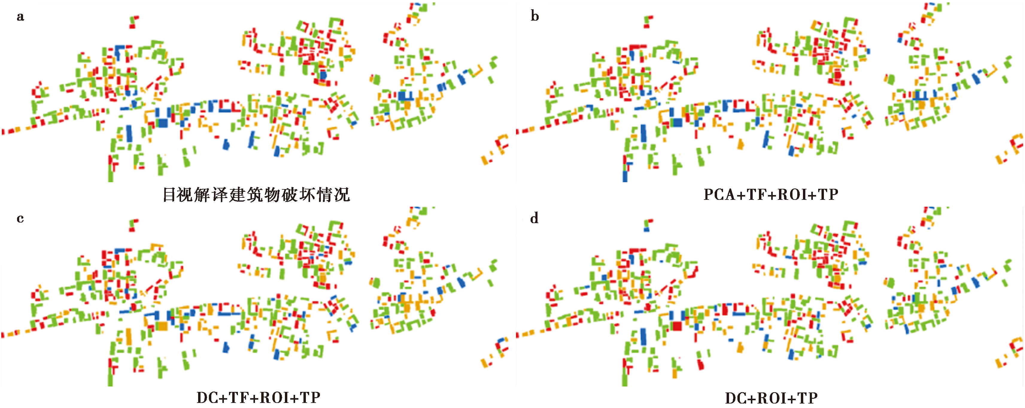
Fig. 9 Statistics and distribution of damaged buildings in different models.
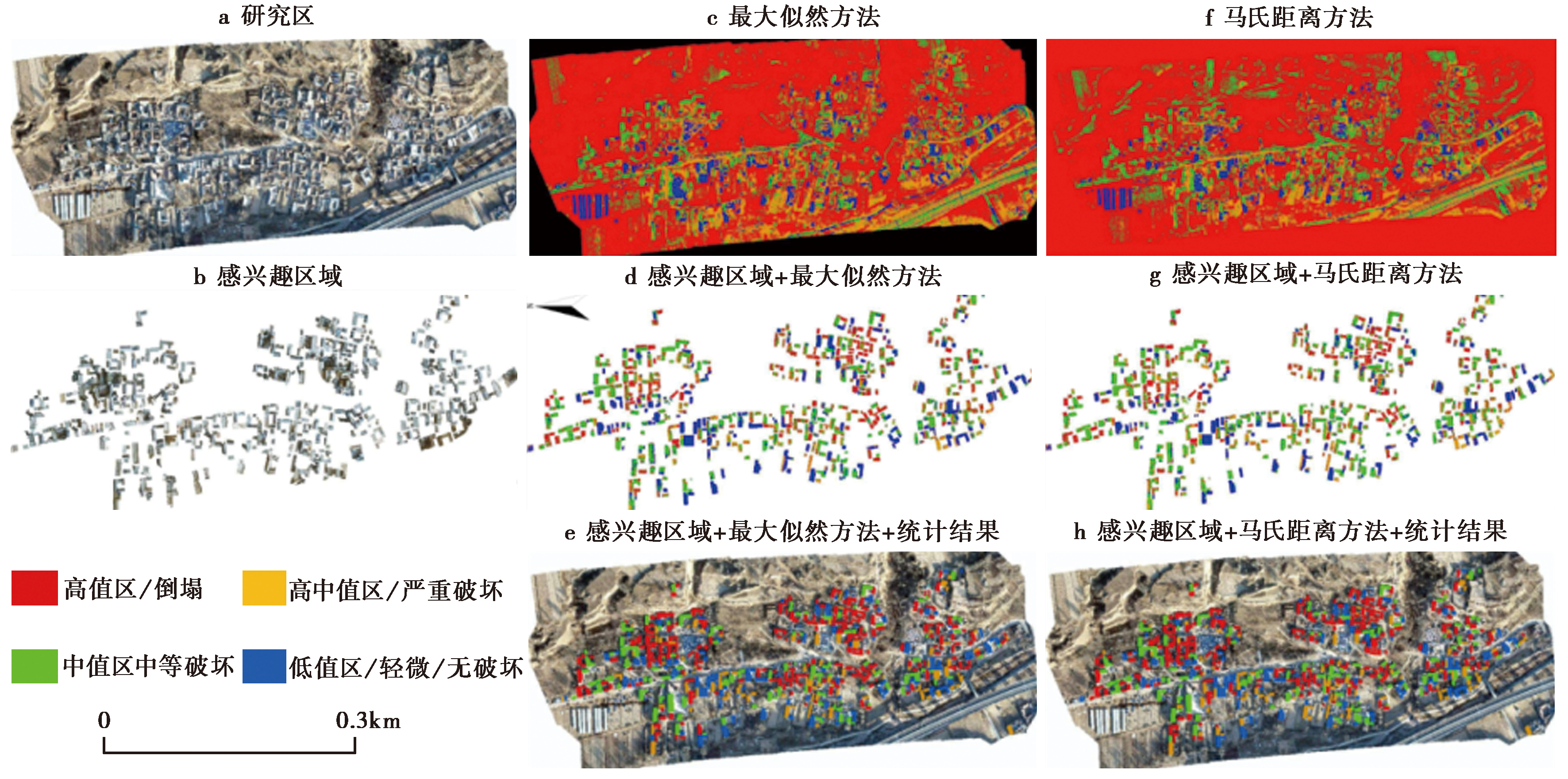
Fig. 10 Comparative analysis of different algorithms.
| 模型 | 预测结果/pixel | 总体占比/% | ||||||||||||
|---|---|---|---|---|---|---|---|---|---|---|---|---|---|---|
| 倒塌 (红色) | 严重破坏 (黄色) | 中等破坏 (绿色) | 轻微 (或无破坏) (蓝色) | 倒塌 (红色) | 严重破坏 (黄色) | 中等破坏 (绿色) | 轻微 (或无破坏) (蓝色) | |||||||
| ROI+ML+SP | 1170711 | 552229 | 876898 | 419524 | 38.77 | 18.28 | 29.06 | 13.89 | ||||||
| ML+SP | 22384549 | 25642512 | 16159087 | 7800097 | 31.09 | 35.62 | 22.46 | 10.83 | ||||||
| ROI+MD+SP | 1183106 | 596125 | 961764 | 278367 | 39.18 | 19.74 | 31.86 | 9.22 | ||||||
| MD+SP | 19067264 | 20886738 | 23448224 | 8584019 | 26.48 | 29.01 | 32.59 | 11.92 | ||||||
Table9 Pixel statistical results of building damage detection based on MD, NN, SVM and ML methods
| 模型 | 预测结果/pixel | 总体占比/% | ||||||||||||
|---|---|---|---|---|---|---|---|---|---|---|---|---|---|---|
| 倒塌 (红色) | 严重破坏 (黄色) | 中等破坏 (绿色) | 轻微 (或无破坏) (蓝色) | 倒塌 (红色) | 严重破坏 (黄色) | 中等破坏 (绿色) | 轻微 (或无破坏) (蓝色) | |||||||
| ROI+ML+SP | 1170711 | 552229 | 876898 | 419524 | 38.77 | 18.28 | 29.06 | 13.89 | ||||||
| ML+SP | 22384549 | 25642512 | 16159087 | 7800097 | 31.09 | 35.62 | 22.46 | 10.83 | ||||||
| ROI+MD+SP | 1183106 | 596125 | 961764 | 278367 | 39.18 | 19.74 | 31.86 | 9.22 | ||||||
| MD+SP | 19067264 | 20886738 | 23448224 | 8584019 | 26.48 | 29.01 | 32.59 | 11.92 | ||||||

Fig. 11 Application of the model(PCA+TF+ROI+CD) in Yangbi 6.4 earthquake.
| 案例 | 分析指标 | 处理时间 | 匹配精度 | ||||||
|---|---|---|---|---|---|---|---|---|---|
| 影像范围 /km2 | 影像 分辨率 /m | 航拍及影像 拼接时间 /h | 建筑物 轮廓提取 /h | 预处理/h (几何校正、 插值) | 自动配准 耗时 /h | 总耗时 /h | 震前 卫星 影像 | 震后 无人机 影像 | |
| 甘肃积石山 6.2级地震 | 0.62 | 卫星:0.72 插值至0.053 | 2.5 | 1.2 (611栋) | 1.3 | 1 | 6 | 94%±2% | 88%±4% |
| 云南漾濞 6.4级地震 | 0.49 | 卫星:0.8 插值至0.045 | 2 | 3 (1295栋) | 1 | 1 | 7 | 93%±3% | 91%±3% |
| 案例 | 匹配精度 | 主要限制 | 对比说明 | 计算机硬件 | |||||
| 平均 NCC值 | 最大RMS 误差/pixel | 地形影响 | 损毁区域误匹配率依赖后期处理滤波(均值、矩形度、面积阈值) | ||||||
| 甘肃积石山 6.2级地震 | 0.75 | 1.2 | 山区区域 匹配失败率20% | 27.5%(坍塌建筑 轮廓模糊) | 甘肃因塌陷形变 复杂,精度略低; 云南纹理清晰, 匹配更稳定 | I9-10885H, 64GB NVIDIA Quadro T2000, 4G | |||
| 云南漾濞 6.4级地震 | 0.68 | 1.8 | 盆地区域 NCC降低至0.55 | 23%(坍塌建筑 轮廓模糊) | |||||
Table12 Model performance and applicability analysis
| 案例 | 分析指标 | 处理时间 | 匹配精度 | ||||||
|---|---|---|---|---|---|---|---|---|---|
| 影像范围 /km2 | 影像 分辨率 /m | 航拍及影像 拼接时间 /h | 建筑物 轮廓提取 /h | 预处理/h (几何校正、 插值) | 自动配准 耗时 /h | 总耗时 /h | 震前 卫星 影像 | 震后 无人机 影像 | |
| 甘肃积石山 6.2级地震 | 0.62 | 卫星:0.72 插值至0.053 | 2.5 | 1.2 (611栋) | 1.3 | 1 | 6 | 94%±2% | 88%±4% |
| 云南漾濞 6.4级地震 | 0.49 | 卫星:0.8 插值至0.045 | 2 | 3 (1295栋) | 1 | 1 | 7 | 93%±3% | 91%±3% |
| 案例 | 匹配精度 | 主要限制 | 对比说明 | 计算机硬件 | |||||
| 平均 NCC值 | 最大RMS 误差/pixel | 地形影响 | 损毁区域误匹配率依赖后期处理滤波(均值、矩形度、面积阈值) | ||||||
| 甘肃积石山 6.2级地震 | 0.75 | 1.2 | 山区区域 匹配失败率20% | 27.5%(坍塌建筑 轮廓模糊) | 甘肃因塌陷形变 复杂,精度略低; 云南纹理清晰, 匹配更稳定 | I9-10885H, 64GB NVIDIA Quadro T2000, 4G | |||
| 云南漾濞 6.4级地震 | 0.68 | 1.8 | 盆地区域 NCC降低至0.55 | 23%(坍塌建筑 轮廓模糊) | |||||
| [1] |
陈志鹏, 邓鹏, 种劲松, 等. 2002. 纹理特征在SAR图像变化检测中的应用[J]. 遥感技术与应用, 17(3): 162-166.
|
|
|
|
| [2] |
杜浩国, 林旭川, 张建国, 等. 2021a. 基于改进蚁群算法与无人机影像的震害识别方法及其在漾濞地震中的应用[J]. 地震地质, 43(4): 1013-1029. doi: 10.3969/j.issn.0253-4967.2021.04.018.
|
|
|
|
| [3] |
杜浩国, 张方浩, 卢永坤, 等. 2021b. 基于多源遥感影像的2021年云南漾濞 MS6.4 地震灾区建筑物信息识别与震害分析[J]. 地震研究, 44(3): 490-498.
|
|
|
|
| [4] |
范熙伟, 聂高众, 邓砚, 等. 2017. 基于摄影测量技术的房屋提取方法: 以中国西部地区乡村为例[J]. 地震地质, 39(4): 805-818. doi: 10.3969/j.issn.0253-4967.2017.04.014.
|
|
DOI |
|
| [5] |
郭建兴, 张宇翔, 姬建中, 等. 2020. 利用居民地建筑物数据和高分遥感影像评估地震烈度的方法初探[J]. 地震地质, 42(4): 968-980. doi: 10.3969/j.issn.0253-4967.2020.04.013.
|
|
DOI |
|
| [6] |
井然, 宫兆宁, 朱文定, 等. 2020. 多尺度SLIC-GMRF与FCNSVM联合的高分影像建筑物提取[J]. 遥感学报, 24(1): 11-26.
|
|
DOI URL |
|
| [7] |
李强, 张景发, 龚丽霞, 等. 2018. SAR图像纹理特征相关变化检测的震害建筑物提取[J]. 遥感学报, 22(S1): 128-138.
|
|
|
|
| [8] |
刘莹, 陶超, 闫培, 等. 2017. 图割能量驱动的高分辨率遥感影像震害损毁建筑物检测[J]. 测绘学报, 46(7): 910-917.
DOI |
|
DOI |
|
| [9] |
宋平, 聂高众, 邓砚, 等. 2016. 基于现场调查的地震灾害损失预评估: 以云南省德宏傣族景颇族自治州为例[J]. 地震地质, 38(4): 1148-1159. doi: 10.3969/j.issn.0253-4967.2016.04.027.
|
|
DOI |
|
| [10] |
王晓青, 黄树松, 丁香, 等. 2015. 尼泊尔8.1级地震建筑物震害遥感提取与分析[J]. 震灾防御技术, 10(3): 481-490.
|
|
|
|
| [11] |
肖本夫, 袁小祥, 陈波, 等. 2023. 基于倾斜摄影技术的典型情景可视化震害定量评估: 以四川马尔康震群为例[J]. 地震地质, 45(4): 847-863. doi: 10.3969/j.issn.0253-4967.2023.04.003.
|
|
DOI |
|
| [12] |
许强, 彭大雷, 范宣梅, 等. 2025. 甘肃积石山6.2级地震触发青海中川乡液化型滑坡-泥流特征与成因机理[J]. 武汉大学学报(信息科学版), 50(2): 207-222.
|
|
|
|
| [13] |
游永发, 王思远, 王斌, 等. 2019. 高分辨率遥感影像建筑物分级提取[J]. 遥感学报, 23(1): 125-136.
|
|
DOI URL |
|
| [14] |
张剑清, 佘琼, 潘励. 2008. 基于LBP/C纹理的遥感影像居民地变化检测[J]. 武汉大学学报(信息科学版), 33(1): 7-11.
|
|
|
|
| [15] |
张景发, 李强, 焦其松, 等. 2017. 建筑物震害多源遥感特征与机理分析[J]. 地震学报, 39(2): 257-272.
|
|
|
|
| [16] |
张凌, 谭璇, 宋冬梅, 等. 2019. 基于马尔科夫随机场的单时相震害影像受损建筑物识别方法[J]. 地震地质, 41(5): 1273-1288. doi: 10.3969/j.issn.0253-4967.2019.05.014.
|
|
DOI |
|
| [17] |
DOI URL |
| [18] |
DOI URL |
| [19] |
DOI URL |
| [20] |
DOI URL |
| [21] |
DOI URL |
| [22] |
DOI URL |
| [23] |
DOI URL |
| [24] |
DOI URL |
| [25] |
DOI URL |
| [26] |
DOI URL |
| [27] |
DOI URL |
| [28] |
DOI URL |
| [29] |
DOI URL |
| [30] |
DOI URL |
| [1] | ZHANG Li-juan, WAN Yong-ge, WANG Fu-chang, JIN Zhi-tong, CUI Hua-wei. GEOMETRY OF SEISMOGENIC FAULTS OF THE 2021 YANGBI EARTHQUAKE SEQUENCE DETERMINED BY FUZZY CLUSTERING ALGORITHM [J]. SEISMOLOGY AND GEOLOGY, 2022, 44(6): 1634-1647. |
| [2] | LI Jian-kai, TANG Ji. PRINCIPAL COMPONENT ANALYSIS AND LOCAL CORRELA-TION TRACKING AS TOOLS FOR REVEALING AND ANALYZING SEISMO-ELECTROMAGNETIC SIGNAL OF EARTHQAUKE [J]. SEISMOLOGY AND GEOLOGY, 2017, 39(3): 517-535. |
| [3] | LI Cheng-fan, DAI Yang-yang, ZHAO Jun-juan, YIN Jing-yuan, ZHOU Shi-qiang. REMOTE SENSING DETECTION OF VOLCANIC ASH CLOUD USING INDEPENDENT COMPONENT ANALYSIS [J]. SEISMOLOGY AND GEOLOGY, 2014, 36(1): 137-147. |
| Viewed | ||||||
|
Full text |
|
|||||
|
Abstract |
|
|||||
Copyright © SEISMOLOGY AND GEOLOGY, All Rights Reserved.
Tel: 010-62009049/9063 E-mail: dzdz@ies.ac.cn
Powered by Beijing Magtech Co., Ltd.