
SEISMOLOGY AND GEOLOGY ›› 2026, Vol. 48 ›› Issue (4): 1122-1137.DOI: 10.3969/j.issn.0253-4967.20250009
• Research paper • Previous Articles Next Articles
AN IMPROVED METHOD FOR ESTIMATING ENGINEERING SITE VS30 BASED ON TERRAIN FEATURES AND SLOPE——A CASE STUDY OF XINJIANG REGION
JIAO Feng1,2)( ), LIU Ye1,2),*(), REN Ye-fei1,2), WANG Hong-wei1,2), WEN Rui-zhi1,2)
- 1)
Key Laboratory of Earthquake Engineering and Engineering Vibration ,Institute of Engineering Mechanics, China Earthquake Administration
2)Key Laboratory of Earthquake Disaster Mitigation ,Ministry of Emergency
-
Received:2025-01-20Revised:2025-05-19Online:2026-08-20Published:2026-09-09
一种基于地形特征和坡度的工程场地VS30 估计改进方法——以新疆地区为例
焦峰1,2)(), 刘也1,2),*(), 任叶飞1,2), 王宏伟1,2), 温瑞智1,2)
- 1)
中国地震局工程力学研究所 ,地震工程与工程振动重点实验室
2)地震灾害防治应急管理部重点实验室
-
通讯作者:* 刘也, 男, 1995年生, 博士, 助理研究员, 主要从事工程地震相关研究, E-mail: liuye@iem.ac.cn。 -
作者简介:焦峰, 男, 1999年生, 2025年于中国地震局工程力学研究所获结构工程专业硕士学位, 主要研究方向为地震动场地效应, E-mail: 961215392@qq.com。
-
基金资助:国家重点研发计划项目(2023YFE0102900); 国家自然科学基金(U2239252); 国家自然科学基金(52478567)

Cite this article
JIAO Feng, LIU Ye, REN Ye-fei, WANG Hong-wei, WEN Rui-zhi. AN IMPROVED METHOD FOR ESTIMATING ENGINEERING SITE VS30 BASED ON TERRAIN FEATURES AND SLOPE——A CASE STUDY OF XINJIANG REGION[J]. SEISMOLOGY AND GEOLOGY, 2026, 48(4): 1122-1137.
焦峰, 刘也, 任叶飞, 王宏伟, 温瑞智. 一种基于地形特征和坡度的工程场地VS30 估计改进方法——以新疆地区为例[J]. 地震地质, 2026, 48(4): 1122-1137.
share this article
Add to citation manager EndNote|Ris|BibTeX
URL: https://www.dzdz.ac.cn/EN/10.3969/j.issn.0253-4967.20250009
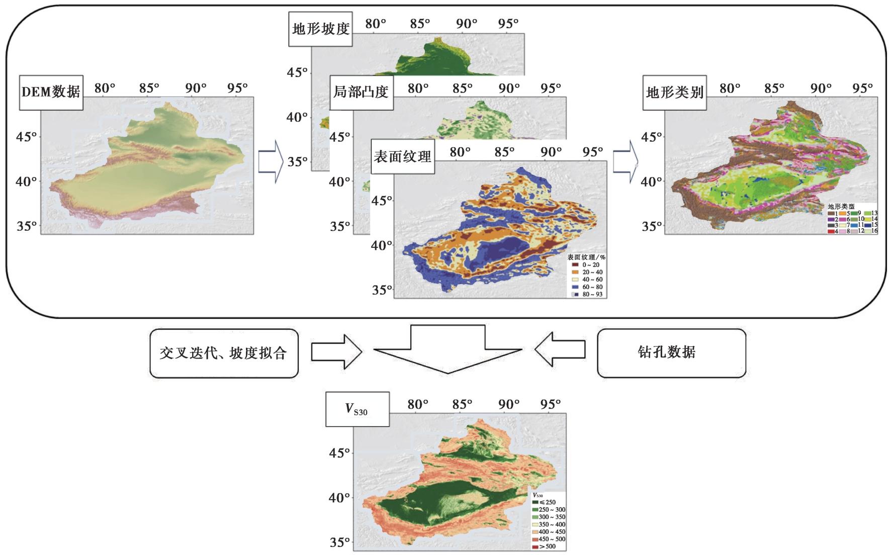
Fig. 1 Site classification and improved method flowchart.
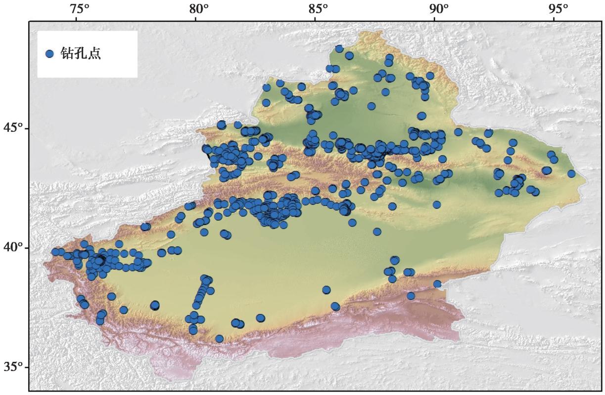
Fig. 2 Spatial distribution of borehole data in Xinjiang region.
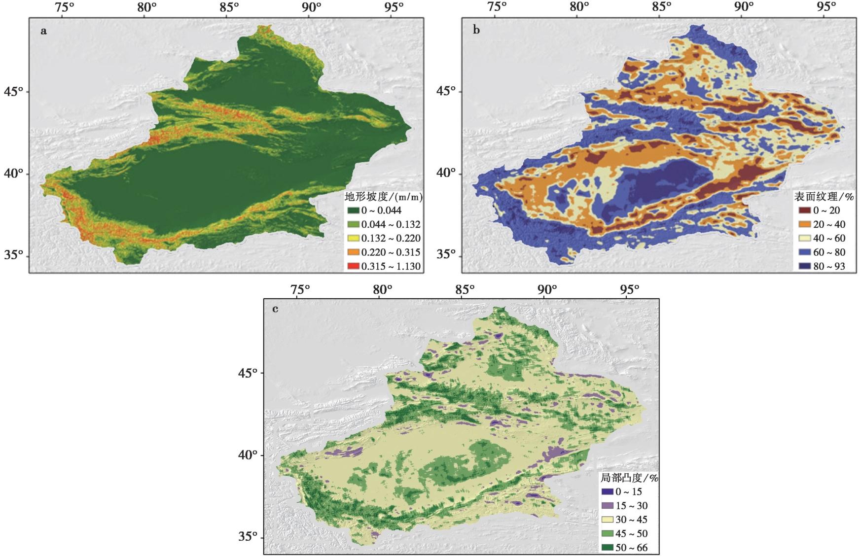
Fig. 3 Calculation results of terrain feature values in Xinjiang region.
| 地形特征 | 分类标准的阈值 | ||
|---|---|---|---|
| 第1阈值 | 第2阈值 | 第3阈值 | |
| 地形坡度/(m/m) | 0.056 | 0.015 | 0.005 |
| 表明纹理/% | 51.89 | 47.13 | 45.11 |
| 局部凸度/% | 40.33 | 40.30 | 40.29 |
Table1 The results of three threshold levels for three terrain features in Xinjiang
| 地形特征 | 分类标准的阈值 | ||
|---|---|---|---|
| 第1阈值 | 第2阈值 | 第3阈值 | |
| 地形坡度/(m/m) | 0.056 | 0.015 | 0.005 |
| 表明纹理/% | 51.89 | 47.13 | 45.11 |
| 局部凸度/% | 40.33 | 40.30 | 40.29 |
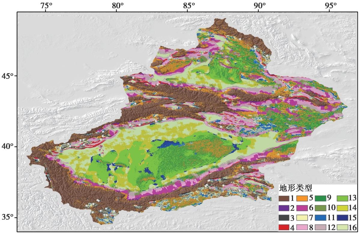
Fig. 4 16-class terrain classification map of Xinjiang region.
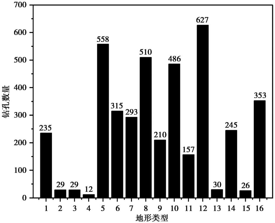
Fig. 5 Histogram of borehole distribution under different terrain categories in Xinjiang.
| 地形组合 | F | p | 是否通过F检验 |
|---|---|---|---|
| 1+2 | 1.6334 | 0.0265 | 否 |
| 3+4 | 0.4487 | 0.9372 | 是 |
| 13+14 | 1.6271 | 0.1633 | 是 |
| 15+16 | 0.7999 | 0.9752 | 是 |
Table2 F-test results of the subdataset
| 地形组合 | F | p | 是否通过F检验 |
|---|---|---|---|
| 1+2 | 1.6334 | 0.0265 | 否 |
| 3+4 | 0.4487 | 0.9372 | 是 |
| 13+14 | 1.6271 | 0.1633 | 是 |
| 15+16 | 0.7999 | 0.9752 | 是 |
| 地形类型 | 钻孔数量 | 回归系数 | 交叉验证法VS30/m·s-1 | ||
|---|---|---|---|---|---|
| a | b | ||||
| 1 | 153 | 6.796 | 0.102 | ||
| 2 | 19 | 485 | |||
| 3-4 | 27 | 417 | |||
| 5 | 363 | 422 | |||
| 6 | 205 | 6.572 | 0.120 | ||
| 7 | 190 | 5.580 | -0.143 | ||
| 8 | 332 | 438 | |||
| 9 | 137 | 382 | |||
| 10 | 316 | 9.222 | 0.729 | ||
| 11 | 102 | 428 | |||
| 12 | 408 | 8.798 | 0.635 | ||
| 13-14 | 179 | 6.021 | 0.086 | ||
| 15-16 | 243 | 6.572 | 0.178 | ||
Table3 Best predicted VS30 values for each terrain category under different classification schemes
| 地形类型 | 钻孔数量 | 回归系数 | 交叉验证法VS30/m·s-1 | ||
|---|---|---|---|---|---|
| a | b | ||||
| 1 | 153 | 6.796 | 0.102 | ||
| 2 | 19 | 485 | |||
| 3-4 | 27 | 417 | |||
| 5 | 363 | 422 | |||
| 6 | 205 | 6.572 | 0.120 | ||
| 7 | 190 | 5.580 | -0.143 | ||
| 8 | 332 | 438 | |||
| 9 | 137 | 382 | |||
| 10 | 316 | 9.222 | 0.729 | ||
| 11 | 102 | 428 | |||
| 12 | 408 | 8.798 | 0.635 | ||
| 13-14 | 179 | 6.021 | 0.086 | ||
| 15-16 | 243 | 6.572 | 0.178 | ||
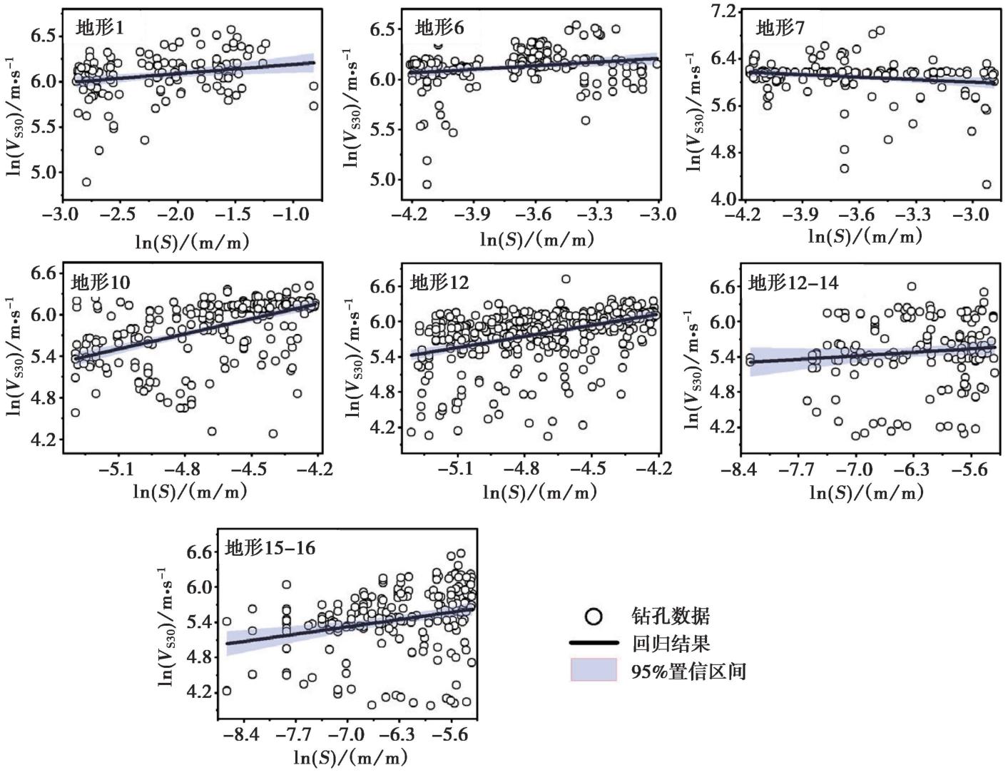
Fig. 6 Regression results of VS30 and slope for terrain classes 1, 6, 10, 12, 13-14, and 15-16.
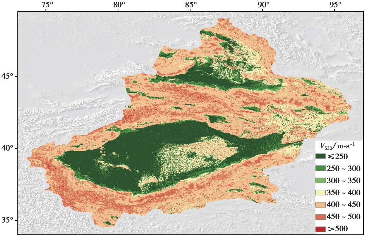
Fig. 7 VS30 spatial distribution in Xinjiang region based on the Terrain-Slope hybrid method.
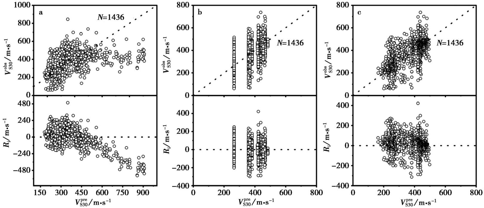
Fig. 8 Residual analysis of different prediction models.
| 模型 | MEAN | STD | MAE | RMSE |
|---|---|---|---|---|
| WA07 | 0.0700 | 0.3284 | 0.2609 | 0.3357 |
| Yong12 | -0.0332 | 0.2789 | 0.1830 | 0.2807 |
| “地形-坡度”混合法 | 0.0188 | 0.2648 | 0.1749 | 0.2652 |
Table4 Evaluation metric results on the validation set under different models
| 模型 | MEAN | STD | MAE | RMSE |
|---|---|---|---|---|
| WA07 | 0.0700 | 0.3284 | 0.2609 | 0.3357 |
| Yong12 | -0.0332 | 0.2789 | 0.1830 | 0.2807 |
| “地形-坡度”混合法 | 0.0188 | 0.2648 | 0.1749 | 0.2652 |
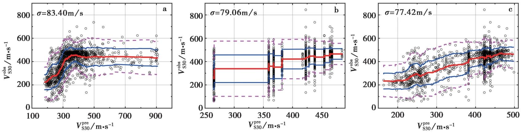
Fig. 9 Plots of the smoothed mean and standard deviation of VS30 values from different models.
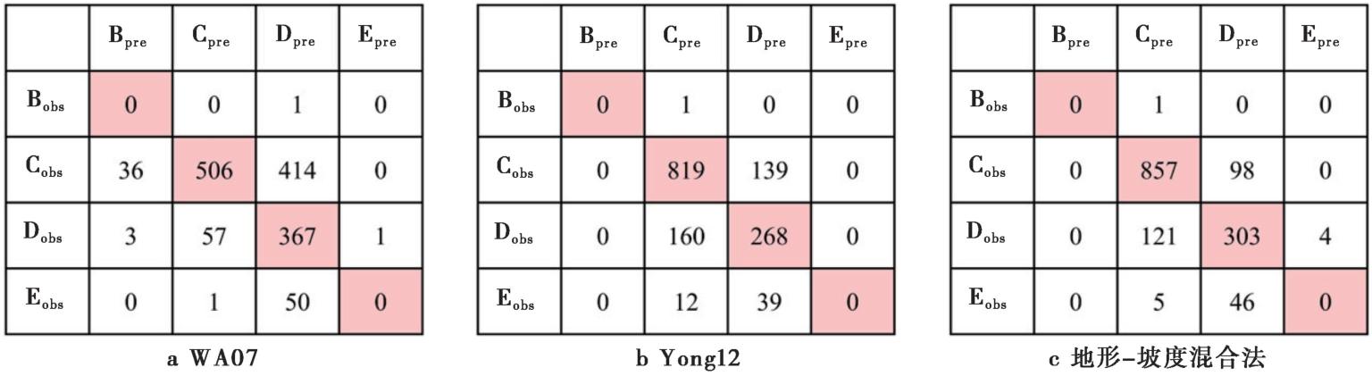
Fig. 10 Confusion matrix results under different models.
| [1] |
李志恒, 谢俊举, 李柯苇, 等. 2024. 山东地区场地剪切波速经验外推模型及其适用性[J]. 地震地质, 46(4): 934-954. doi: 10.3969/j.issn.0253-4967.2024.04.010.
|
|
DOI |
|
| [2] |
刘也, 任叶飞, 王大任, 等. 2023. 基于地震动预测残差分析的工程场地分类标准检验与评价[J]. 工程力学, 40(6): 99-109.
|
|
|
|
| [3] |
彭艳菊, 吕悦军, 黄雅虹, 等. 2009. 工程地震中的场地分类方法及适用性评述[J]. 地震地质, 31(2): 349-362.
DOI |
|
DOI |
|
| [4] |
王宏伟, 温瑞智, 任叶飞. 2021. 考虑区域特征的地震动模拟: 以2020年伽师 MS6.4 地震为例[J]. 地震地质, 43(2): 430-446. doi: 10.3969/j.issn.0253-4967.2021.02.011.
|
|
DOI |
|
| [5] |
张雨婷, 任叶飞, 米欣雪, 等. 2023. 区域场地分类方法研究综述[J]. 世界地震工程, 39(2): 189-199.
|
|
|
|
| [6] |
张雨婷, 任叶飞, 温瑞智, 等. 2022. 基于决策树考虑地形特征的场地参数估计方法[J]. 地球物理学报, 65(2): 698-710.
|
|
|
|
| [7] |
|
| [8] |
DOI URL |
| [9] |
DOI URL |
| [10] |
DOI URL |
| [11] |
|
| [12] |
DOI URL |
| [13] |
DOI URL |
| [14] |
DOI |
| [15] |
DOI URL |
| [16] |
DOI URL |
| [17] |
DOI URL |
| [18] |
DOI URL |
| [19] |
DOI URL |
| [20] |
DOI URL |
| [21] |
DOI URL |
| [22] |
DOI URL |
| [23] |
DOI URL |
| [24] |
DOI URL |
| [25] |
DOI URL |
| [26] |
DOI |
| [27] |
DOI URL |
| [1] | Chu Quanzhi, Wang Liangmou, Guo Shunmin. SEGMENTATION AND RISK ESTIMATION AND RISK EQRTHQUAKES ON QILANSHAN ACTIVE FAUL ZONE [J]. SEISMOLOGY AND GEOLOGY, 1995, 17(2): 116-122. |
| Viewed | ||||||
|
Full text |
|
|||||
|
Abstract |
|
|||||
Copyright © SEISMOLOGY AND GEOLOGY, All Rights Reserved.
Tel: 010-62009049/9063 E-mail: dzdz@ies.ac.cn
Powered by Beijing Magtech Co., Ltd.