
SEISMOLOGY AND GEOLOGY ›› 2025, Vol. 47 ›› Issue (2): 533-546.DOI: 10.3969/j.issn.0253-4967.2025.02.20240160
Previous Articles Next Articles
HIGH-RESOLUTION SHALLOW CRUSTAL S-WAVE VELOCITY STRUCTURE IMAGING IN THE KASHGAR, XINJIANG
HUA Qian1,2)( ), PEI Shun-ping3,1,4),*(), LI Tao4), LIU Han-lin1), LIU Wei1), LI Lei1), LI Jia-wei1), YANG Yi-hai2)
- 1) State Key Laboratory of Tibetan plateau Earth System, Resources and Environment(TPESRE), Institute of Tibetan plateau Research, Chinese Academy of Sciences, Beijing 100101, China
2) Shaanxi Earthquake Agency, Xi'an 710068, China
3) Yunnan University, Kunming 650091, China
4) Institute of Geology, China Earthquake Administration; Xinjiang Pamir Intracontinental Subduction National Observation and Research Station; State Key Laboratory of Earthquake Dynamics and Forecasting, Institute of Geology, China Earthquake Administration, Beijing 100029, China
-
Received:2024-12-16Revised:2025-03-11Online:2025-04-20Published:2025-06-07
喀什市浅层地壳高分辨率S波速度结构成像
花茜1,2)(), 裴顺平3,1,4),*(), 李涛4), 刘翰林1), 刘巍1), 李磊1), 李佳蔚1), 杨宜海2)
- 1) 中国科学院青藏高原研究所, 青藏高原地球系统与资源环境全国重点实验室, 北京 100101
2) 陕西省地震局, 西安 710068
3) 云南大学, 昆明 650091
4) 新疆帕米尔陆内俯冲国家野外科学观测研究站, 地震动力学与强震预测全国重点实验室(中国地震局地质研究所), 北京 100029
-
通讯作者:* 裴顺平, 男, 1974年生, 教授, 主要从事地球内部结构成像和大地震发震机制研究, E-mail: peisp@itpcas.ac.cn。 -
作者简介:花茜, 女, 1990年生, 现为中国科学院青藏高原研究所固体地球物理学专业在读博士研究生, 主要从事背景噪声层析成像研究, E-mail: huaqian20@itpcas.ac.cn。
-
基金资助:国家重点研发计划项目(2022YFC3003700); 国家自然科学基金(U2039203); 国家自然科学基金(42130306)
Cite this article
HUA Qian, PEI Shun-ping, LI Tao, LIU Han-lin, LIU Wei, LI Lei, LI Jia-wei, YANG Yi-hai. HIGH-RESOLUTION SHALLOW CRUSTAL S-WAVE VELOCITY STRUCTURE IMAGING IN THE KASHGAR, XINJIANG[J]. SEISMOLOGY AND GEOLOGY, 2025, 47(2): 533-546.
花茜, 裴顺平, 李涛, 刘翰林, 刘巍, 李磊, 李佳蔚, 杨宜海. 喀什市浅层地壳高分辨率S波速度结构成像[J]. 地震地质, 2025, 47(2): 533-546.
share this article
Add to citation manager EndNote|Ris|BibTeX
URL: https://www.dzdz.ac.cn/EN/10.3969/j.issn.0253-4967.2025.02.20240160
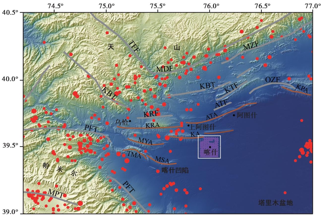
Fig. 1 Regional tectonic structure and seismic distribution and seismic array in the Tianshan-Pamir collision zone.
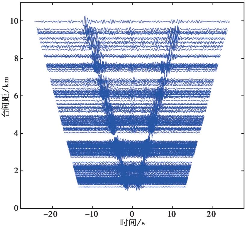
Fig. 2 Cross-correlation waveforms of 0.5~2s with SNR>6.
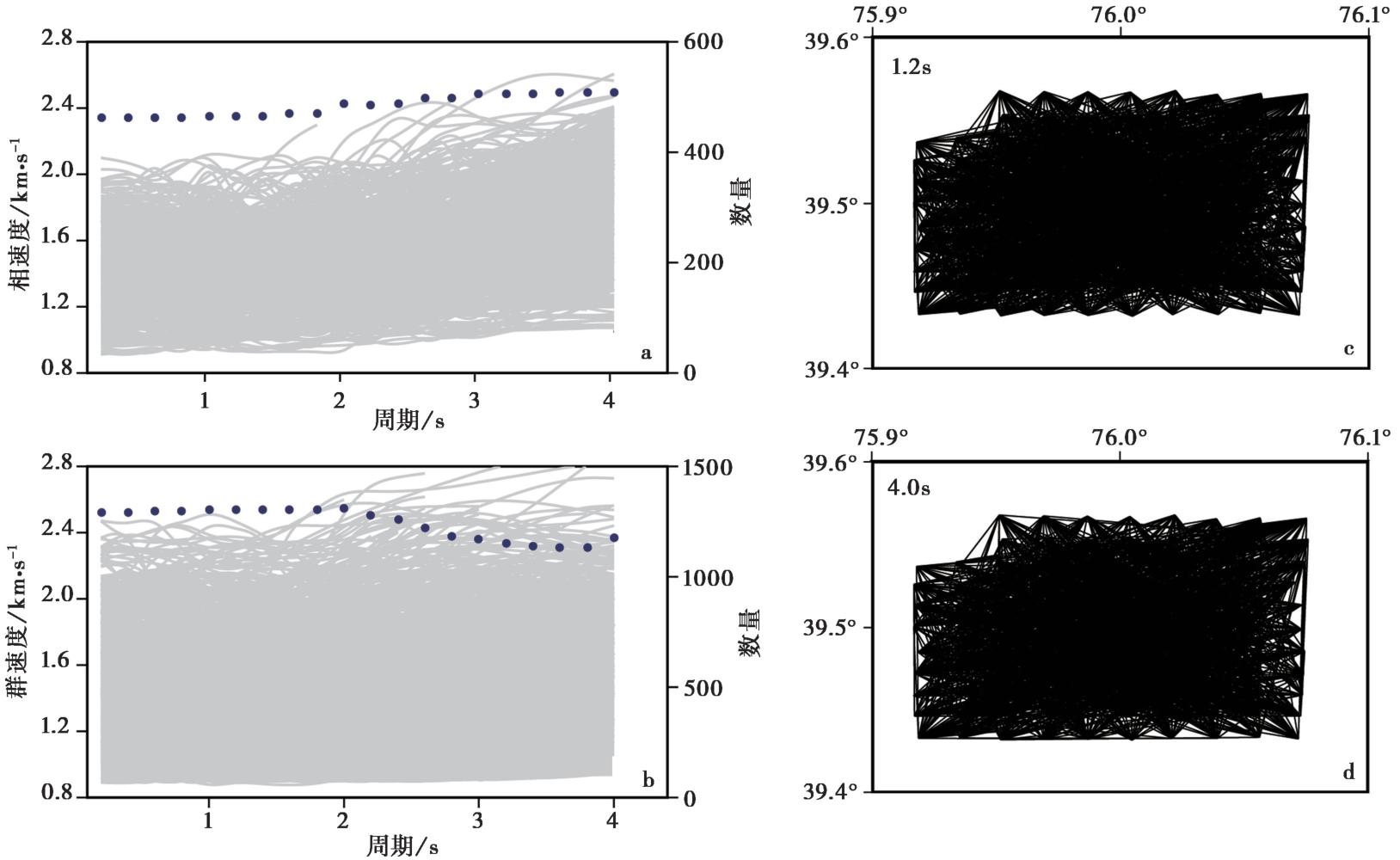
Fig. 3 Dispersion curves for the Rayleigh wave and the path distribution for different periods.
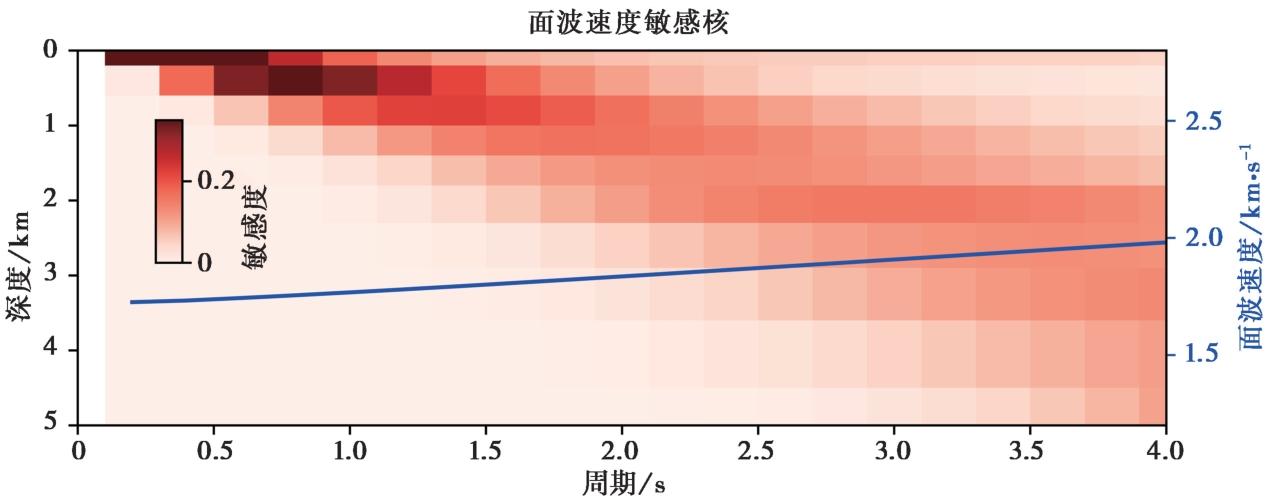
Fig. 4 Sensitivity kernel for dispersion curves of Rayleigh wave.
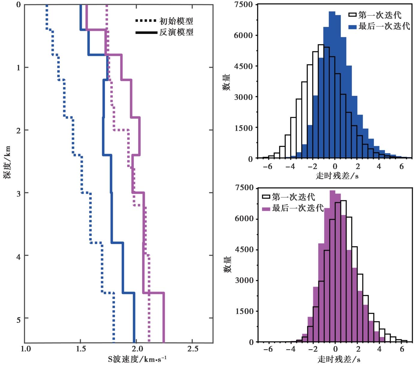
Fig. 5 Comparison of initial velocity models with the inversion models before and after constraint.
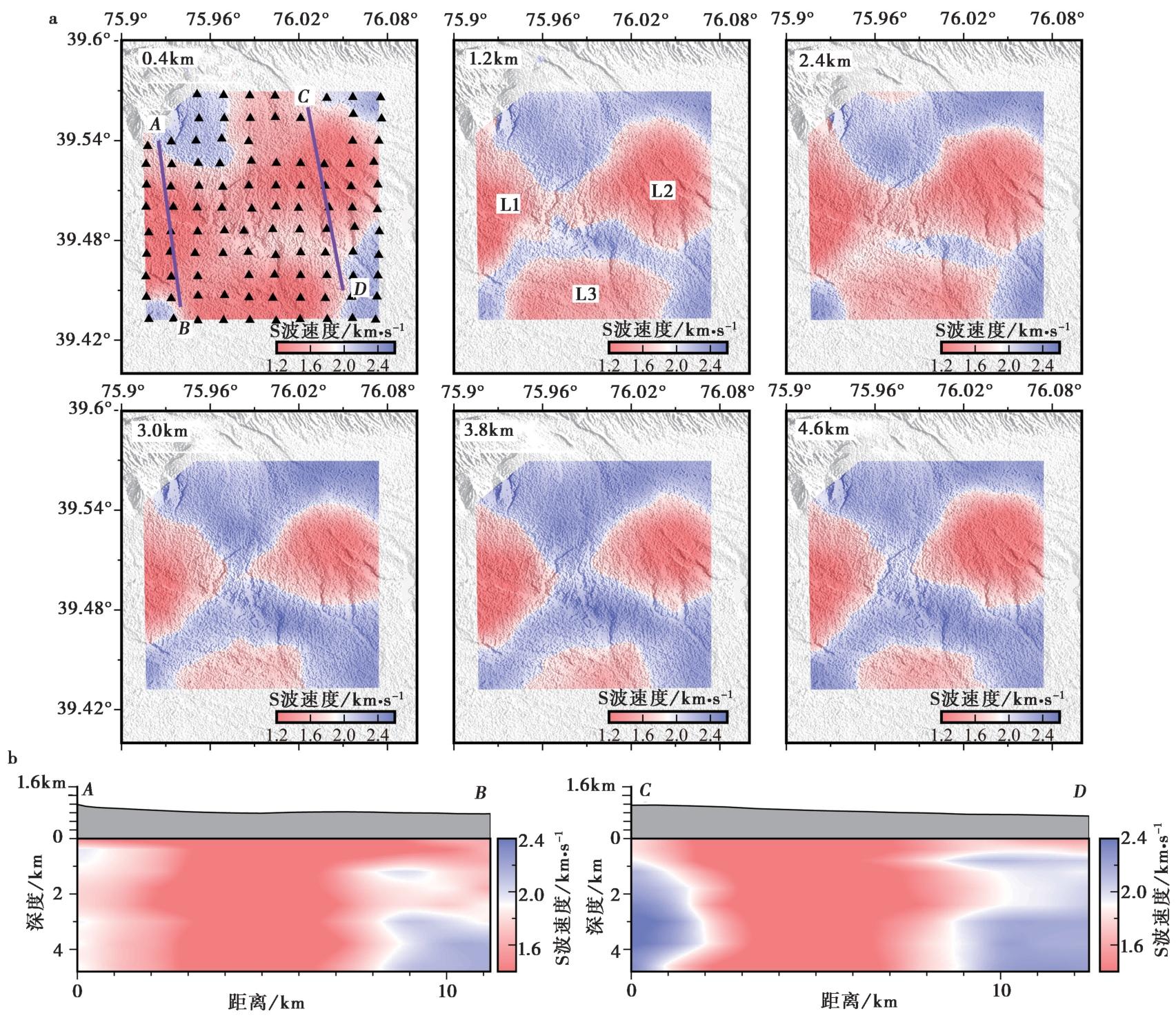
Fig. 6 S-wave velocity structures obtained from 3-D inversion.
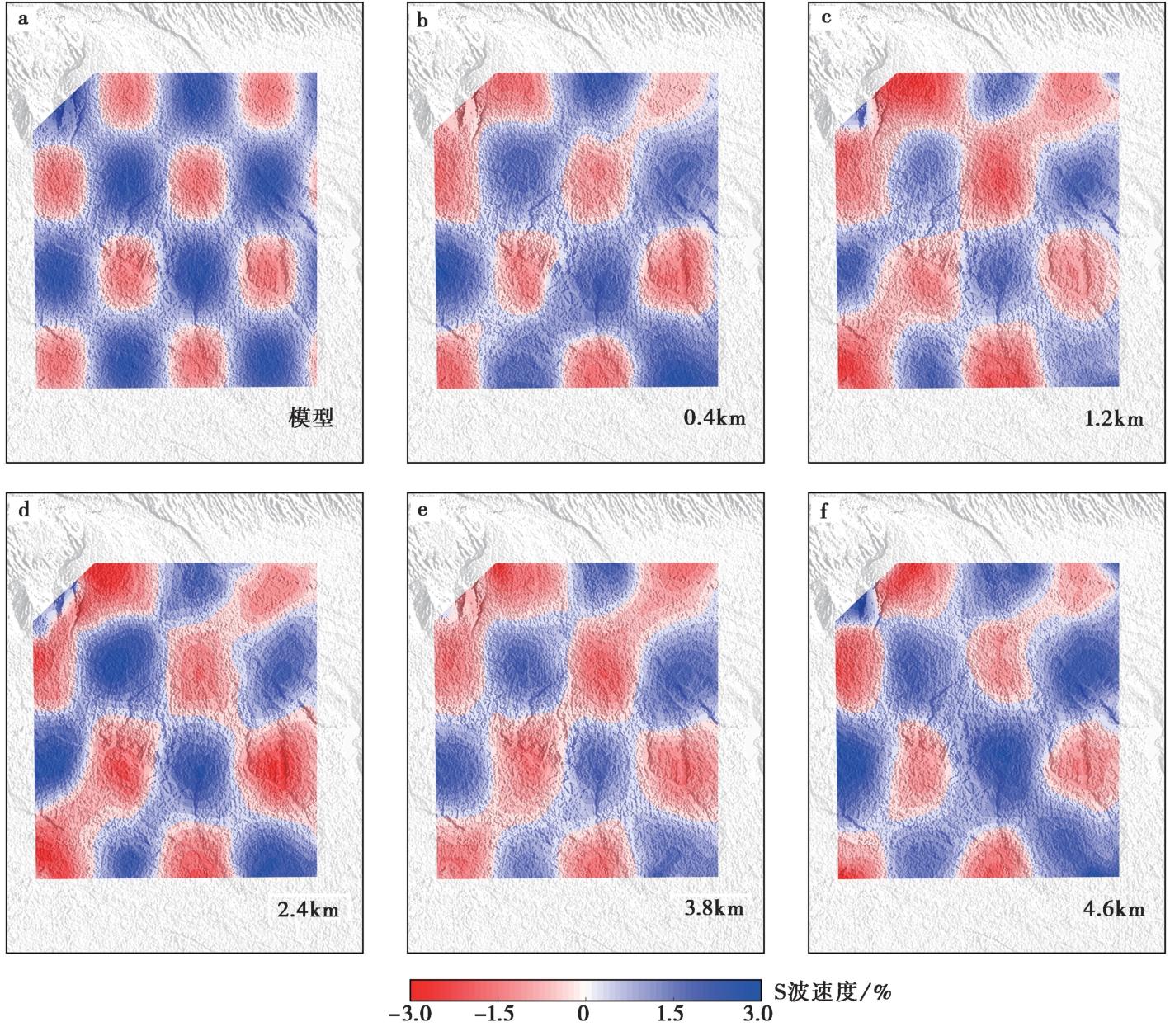
Fig. 7 The checkerboard model(a) and output models at different depths(b—f) in the resolution test.
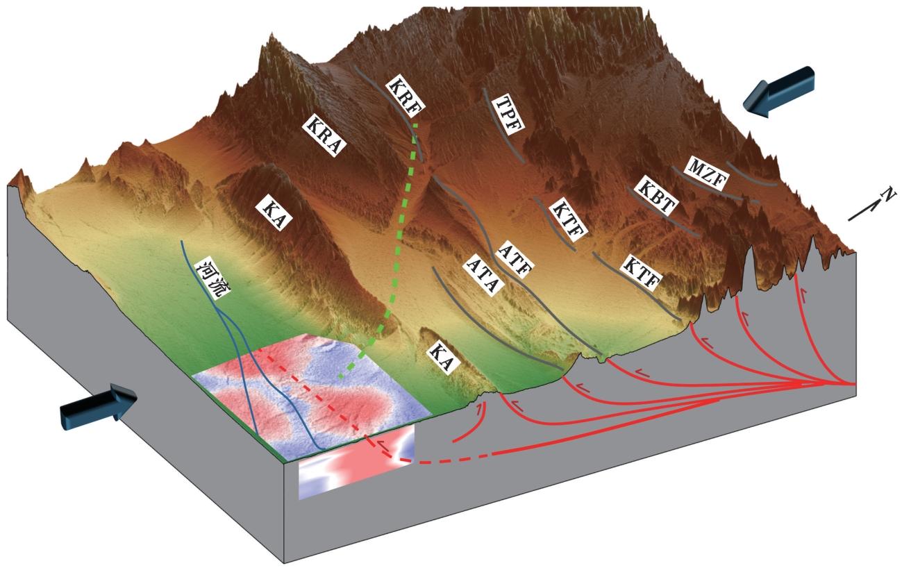
Fig. 8 3-D schematic diagram of the formation mechanism of shallow crustal low velocity anomalies in the Kashgar.
| [1] |
柏美祥. 1987. 阿图什地区地震地质特征[J]. 内陆地震, 1(2): 135-145.
|
|
|
|
| [2] |
陈汉林, 陈亚光, 陈沈强, 等. 2019. 帕米尔弧形构造带的构造过程与地貌特征[J]. 地球学报, 40(1): 55-75.
|
|
|
|
| [3] |
陈杰, 丁国瑜,
|
|
|
|
| [4] |
陈杰, 李涛, 李文巧, 等. 2011. 帕米尔构造结及邻区的晚新生代构造与现今变形[J]. 地震地质, 33(2): 241-259. doi: 10.3969/j.issn.0253-4967.2011.02.001.
|
|
DOI |
|
| [5] |
陈杰,
|
|
|
|
| [6] |
陈庆宇. 2022. 1902年 MW7.7 阿图什地震的构造变形和发震机制研究[D]. 北京: 中国科学院大学(中国科学院空天信息创新研究院).
|
|
|
|
| [7] |
侯贺晟, 高锐, 贺日政, 等. 2012. 西南天山—塔里木盆地结合带浅深构造关系: 深地震反射剖面的初步揭露[J]. 地球物理学报, 55(12): 4116-4125.
|
|
|
|
| [8] |
花茜, 裴顺平, 郭震, 等. 2022. 川藏铁路通麦-鲁朗段浅层结构背景噪声成像[J]. 地球科学, 47(9): 3447-3462.
|
|
|
|
| [9] |
花茜, 裴顺平, 杨宜海, 等. 2024. 泸定 MS6.8 地震震源区震前S波速度结构及b值分布揭示发震机制[J]. 地球物理学报, 67(5): 1767-1780.
|
|
|
|
| [10] |
李玲利, 黄显良, 姚华建, 等. 2020. 合肥市地壳浅部三维速度结构及城市沉积环境初探[J]. 地球物理学报, 63(9): 3307-3323.
DOI |
|
|
|
| [11] |
李涛, 陈杰, 肖伟鹏. 2013. 帕米尔-天山对冲带明尧勒背斜西S倾伏端晚第四纪褶皱变形[J]. 地震地质, 35(2): 234-246. doi: 10.3969/j.issn.0253-4967.2013.02.004.
|
|
DOI |
|
| [12] |
李涛, 陈杰, 肖伟鹏. 2014. 滑脱褶皱陡坎的变形特征和运动学模型: 以帕米尔-南天山前陆地区明尧勒背斜为例[J]. 地震地质, 36(3): 677-691. doi: 10.3969/j.issn.0253-4967.2014.03.011.
|
|
|
|
| [13] |
刘启元, 陈九辉, 李顺成, 等. 2000. 新疆伽师强震群区三维地壳上地幔 S 波速度结构及其地震成因的探讨[J]. 地球物理学报, 43(3): 356-365.
|
|
|
|
| [14] |
苗继军, 贾承造, 侯向辉, 等. 2007. 塔里木盆地西部喀什地区新生代褶皱冲断带构造解析[J]. 地质科学, 42(4): 740-752.
|
|
|
|
| [15] |
倪强. 2019. 喀什凹陷北缘构造特征及其对油气成藏的控制[D]. 北京: 中国石油大学.
|
|
|
|
| [16] |
单新建, 李建华, 张桂芳. 2006. 1997 年玛尼 7.9 级地震的构造环境和地表破裂带特征[J]. 地球物理学报, 49(3): 831-837.
|
|
|
|
| [17] |
沈军, 汪一鹏, 赵瑞斌, 等. 2001. 帕米尔东北缘及塔里木盆地西北部弧形构造的扩展特征[J]. 地震地质, 23(3): 381-389.
|
|
|
|
| [18] |
田勤俭, 丁国瑜, 郝平. 2006. 南天山及塔里木北缘构造带西段地震构造研究[J]. 地震地质, 28(2): 213-223.
|
|
|
|
| [19] |
张云鹏, 王宝善, 林国庆, 等. 2020. 利用密集台阵近震层析成像研究云南宾川上地壳速度结构[J]. 地球物理学报, 63(9): 3292-3306.
DOI |
|
|
|
| [20] |
|
| [21] |
|
| [22] |
|
| [23] |
|
| [24] |
|
| [25] |
|
| [26] |
|
| [27] |
|
| [28] |
|
| [29] |
|
| [30] |
|
| [31] |
|
| [32] |
|
| [33] |
|
| [34] |
|
| [35] |
|
| [36] |
|
| [37] |
|
| [38] |
|
| [39] |
|
| [40] |
|
| [41] |
|
| [42] |
|
| [43] |
|
| [44] |
|
| [45] |
|
| [46] |
|
| [47] |
|
| [48] |
|
| [49] |
|
| [50] |
|
| [51] |
|
| [52] |
|
| [53] |
|
| [54] |
|
| [55] |
|
| [56] |
|
| [57] |
|
| [1] | YANG Jian-wen, JIN Ming-pei, YE Beng, CHA Wen-jian, HEI He-tang. THREE-DIMENSIONAL VELOCITY STRUCTURE AND SEI-SMOGENIC ENVIRONMENT IN THE MIDDLE AND UPPER CRUST OF NORTHWEST YUNNAN FROM AMBIENT NOISE TOMOGRAPHY [J]. SEISMOLOGY AND GEOLOGY, 2025, 47(4): 1113-1131. |
| [2] | JI Yu, ZHANG Guang-wei, REN Jun-jie, HE Jing, WANG Xiao-wei. HIGH-RESOLUTION S-WAVE VELOCITY STRUCTURE OF BEIJING AREA USING AMBIENT NOISE TOMOGRAPHY [J]. SEISMOLOGY AND GEOLOGY, 2025, 47(1): 306-324. |
| [3] | ZHOU Ming, DUAN Yong-hong, TAN Yu-juan, QIU Yong. THE 3-D SHALLOW VELOCITY STRUCTURE OF THE MIDDLE-NORTH SECTION OF THE DONGPU DEPRESSION DERIVED FROM DENSE ARRAY OBSERVATIONS OF AMBIENT NOISE [J]. SEISMOLOGY AND GEOLOGY, 2023, 45(2): 517-535. |
| [4] | GU Qin-ping, KANG Qing-qing, ZHANG Peng, MENG Ke, WU Shan-shan, LI Zheng-kai, WANG Jun-fei, HUANG Qun, JIANG Xin, LI Da-hu. RAYLEIGH WAVE PHASE VELOCITY AND AZIMUTHAL ANISOTROPY OF THE MIDDLE-SOUTHERN SEGMENT OF THE TAN-LU FAULT ZONE AND ADJACENT REGIONS FROM AMBIENT NOISE TOMOGRAPHY [J]. SEISMOLOGY AND GEOLOGY, 2020, 42(5): 1129-1152. |
| [5] | XIONG Cheng, XIE Zu-jun, ZHENG Yong, XIONG Xiong, AI San-xi, XIE Ren-xian. RAYLEIGH WAVE TOMOGRAPHY IN THE CRUST AND UPPER MANTLE OF THE DABIE-TANLU OROGENIC ZONE [J]. SEISMOLOGY AND GEOLOGY, 2019, 41(1): 1-20. |
| Viewed | ||||||
|
Full text |
|
|||||
|
Abstract |
|
|||||
Copyright © SEISMOLOGY AND GEOLOGY, All Rights Reserved.
Tel: 010-62009049/9063 E-mail: dzdz@ies.ac.cn
Powered by Beijing Magtech Co., Ltd.