SEISMOLOGY AND EGOLOGY ›› 2022, Vol. 44 ›› Issue (1): 20-34.DOI: 10.3969/j.issn.0253-4967.2022.01.002
• Research paper • Previous Articles Next Articles
HUANG Shuai-tang1)( ), CHANG Xiang-de1),*(), MA Jian1), HU Wei-hua1), REN Jing2), LIU Jian-ming1), ZHANG Wen-xiu1), LAI Ai-jing3)
Received:2021-03-25
Revised:2021-10-15
Online:2022-02-20
Published:2022-04-20
Contact:
CHANG Xiang-de
黄帅堂1)(), 常想德1),*(), 马建1), 胡伟华1), 任静2), 刘建明1), 张文秀1), 赖爱京3)
通讯作者:
常想德
作者简介:黄帅堂, 男, 1990年生, 2016年于中国地震局地震预测研究所获构造地质学专业硕士学位, 工程师, 研究方向为活动构造与构造地貌, 电话: 0991-3853817, E-mail: shuaith@126.com。
基金资助:CLC Number:
HUANG Shuai-tang, CHANG Xiang-de, MA Jian, HU Wei-hua, REN Jing, LIU Jian-ming, ZHANG Wen-xiu, LAI Ai-jing. A STUDY ON THE SCARPS ALONG THE EASTERN SECTION OF THE KUSONGMUQIKE PIEDMONT FAULT AT THE NORTHERN FOOT OF TIANSHAN[J]. SEISMOLOGY AND EGOLOGY, 2022, 44(1): 20-34.
黄帅堂, 常想德, 马建, 胡伟华, 任静, 刘建明, 张文秀, 赖爱京. 天山北麓库松木契克山山前断裂东段断层陡坎研究[J]. 地震地质, 2022, 44(1): 20-34.
Add to citation manager EndNote|Ris|BibTeX
URL: https://www.dzdz.ac.cn/EN/10.3969/j.issn.0253-4967.2022.01.002
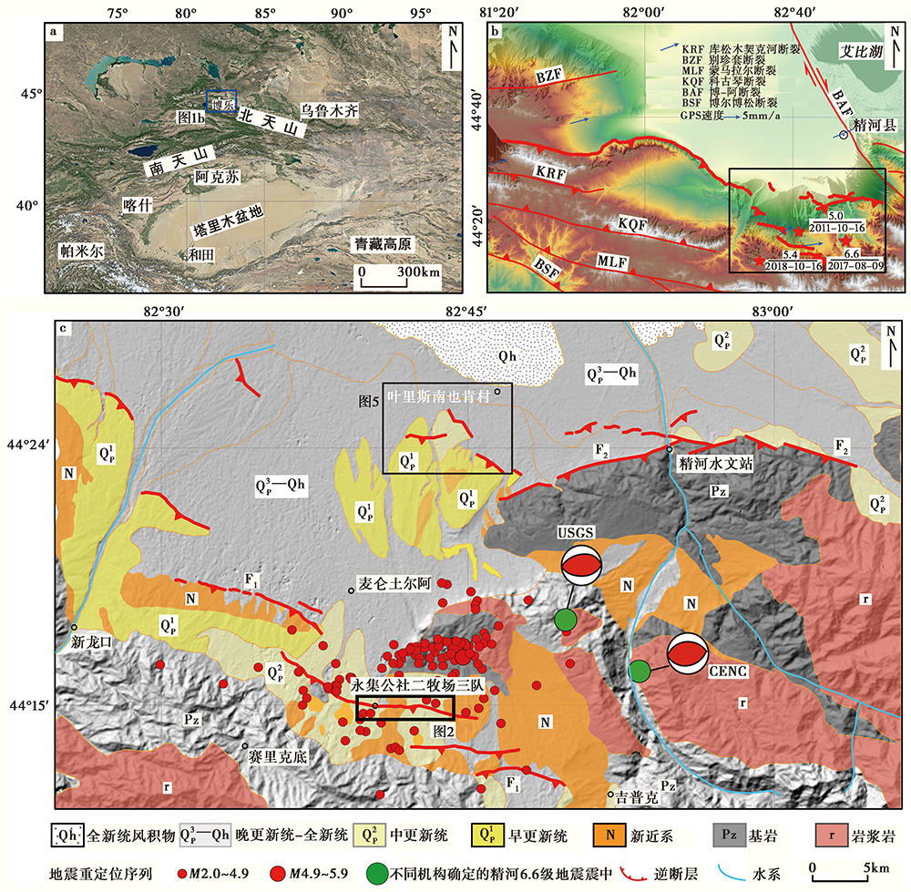
Fig. 1 Map of regional faults in the south of Jinghe area.
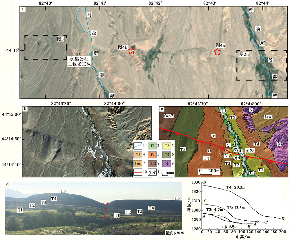
Fig. 2 Satellite image and offset landforms interpretation of the Xinlongkou Fault near the Hustanusu River.
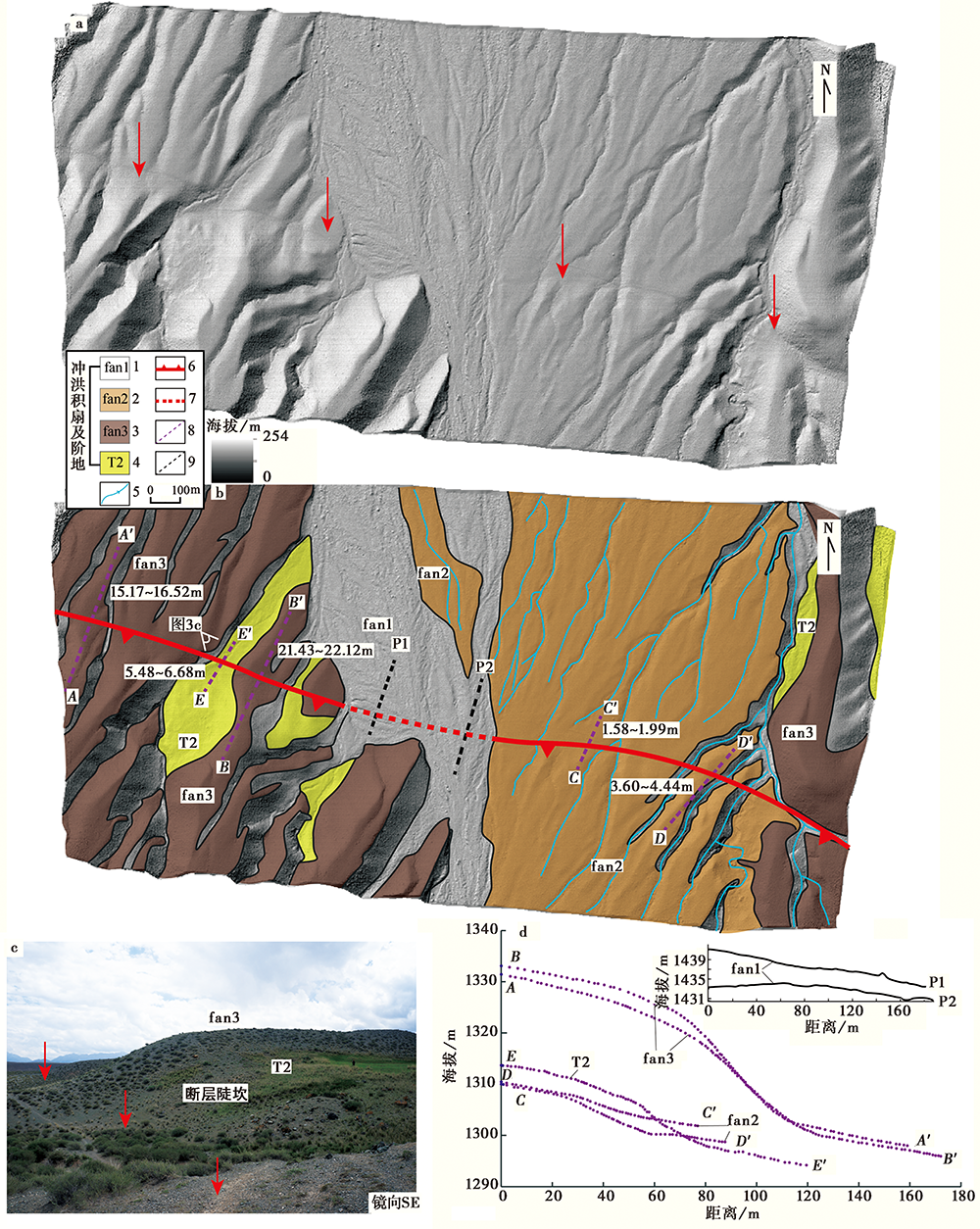
Fig. 3 High-resolution satellite image and photos of the offset landforms west of the Wulasitai River.
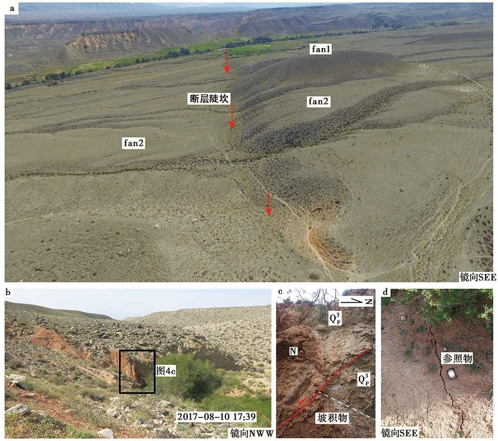
Fig. 4 Fault scarp distribution, fault profile and coseismic surface crack on the east bank of Wulasitai River.
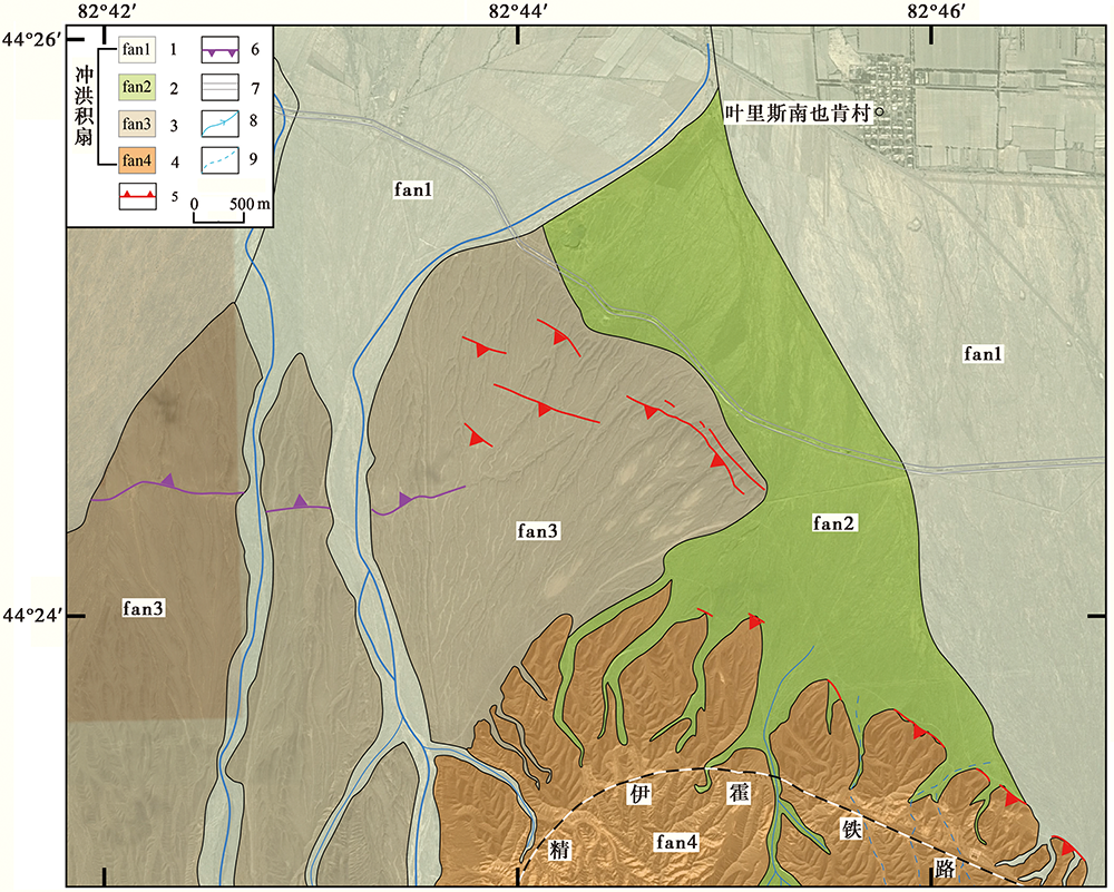
Fig. 5 Satellite image and offset landforms interpretation of the Hydrographic Station Fault.
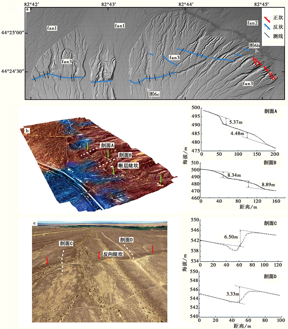
Fig. 6 UAVs images and scarp profiles over the Hydrographic Station Fault.
| 陡坎编号 | 最大高度/m | 最小高度/m | 平均高度/m | 陡坎形态 | 东经/(°) | 北纬/(°) |
|---|---|---|---|---|---|---|
| 1 | 5.0 | 4.9 | 4.2 | 反坎 | 82.703 8 | 44.407 7 |
| 2 | 7.4 | 6.6 | 7.0 | 反坎 | 82.705 9 | 44.408 5 |
| 3 | 5.6 | 4.4 | 5.0 | 反坎 | 82.706 6 | 44.408 6 |
| 4 | 7.0 | 6.0 | 6.5 | 反坎 | 82.709 4 | 44.408 1 |
| 5 | 6.4 | 5.2 | 5.8 | 反坎 | 82.711 8 | 44.407 8 |
| 6 | 7.1 | 7.0 | 7.1 | 反坎 | 82.712 3 | 44.408 0 |
| 7 | 3.1 | 2.4 | 2.7 | 反坎 | 82.733 1 | 44.408 7 |
| 8 | 3.8 | 3.5 | 3.6 | 反坎 | 82.731 5 | 44.408 1 |
| 9 | 3.4 | 3.3 | 3.3 | 反坎 | 82.729 9 | 44.407 8 |
| 10 | 5.9 | 5.3 | 5.5 | 反坎 | 82.728 7 | 44.407 8 |
| 11 | 3.5 | 3.1 | 3.3 | 反坎 | 82.726 5 | 44.407 0 |
| 12 | 9.7 | 7.8 | 8.7 | 反坎 | 82.716 8 | 44.406 9 |
| 13 | 4.4 | 1.5 | 3.0 | 正坎 | 82.755 0 | 44.408 4 |
| 14 | 2.5 | 1.0 | 1.8 | 正坎 | 82.755 6 | 44.408 6 |
| 15 | 8.4 | 8.3 | 8.3 | 正坎 | 82.753 9 | 44.409 9 |
| 16 | 9.2 | 8.6 | 8.9 | 正坎 | 82.753 8 | 44.409 8 |
| 17 | 6.1 | 4.6 | 5.4 | 正坎 | 82.752 4 | 44.411 0 |
| 18 | 4.8 | 4.2 | 4.5 | 正坎 | 82.751 8 | 44.410 7 |
| 19 | 2.6 | 2.1 | 2.3 | 正坎 | 82.749 4 | 44.413 2 |
| 20 | 3.7 | 3.7 | 3.7 | 正坎 | 82.748 2 | 44.412 6 |
| 21 | 0.3 | 0.2 | 0.3 | 正坎 | 82.744 3 | 44.413 4 |
| 22 | 0.7 | 0.5 | 0.6 | 反坎 | 82.740 0 | 44.412 7 |
| 23 | 1.0 | 1.0 | 1.0 | 反坎 | 82.739 0 | 44.413 0 |
| 24 | 0.5 | 0.5 | 0.5 | 反坎 | 82.735 8 | 44.414 0 |
| 25 | 0.6 | 0.6 | 0.6 | 正坎 | 82.735 5 | 44.413 5 |
Table 1 Heights of scarps on profiles of the Hydrographic Station Fault
| 陡坎编号 | 最大高度/m | 最小高度/m | 平均高度/m | 陡坎形态 | 东经/(°) | 北纬/(°) |
|---|---|---|---|---|---|---|
| 1 | 5.0 | 4.9 | 4.2 | 反坎 | 82.703 8 | 44.407 7 |
| 2 | 7.4 | 6.6 | 7.0 | 反坎 | 82.705 9 | 44.408 5 |
| 3 | 5.6 | 4.4 | 5.0 | 反坎 | 82.706 6 | 44.408 6 |
| 4 | 7.0 | 6.0 | 6.5 | 反坎 | 82.709 4 | 44.408 1 |
| 5 | 6.4 | 5.2 | 5.8 | 反坎 | 82.711 8 | 44.407 8 |
| 6 | 7.1 | 7.0 | 7.1 | 反坎 | 82.712 3 | 44.408 0 |
| 7 | 3.1 | 2.4 | 2.7 | 反坎 | 82.733 1 | 44.408 7 |
| 8 | 3.8 | 3.5 | 3.6 | 反坎 | 82.731 5 | 44.408 1 |
| 9 | 3.4 | 3.3 | 3.3 | 反坎 | 82.729 9 | 44.407 8 |
| 10 | 5.9 | 5.3 | 5.5 | 反坎 | 82.728 7 | 44.407 8 |
| 11 | 3.5 | 3.1 | 3.3 | 反坎 | 82.726 5 | 44.407 0 |
| 12 | 9.7 | 7.8 | 8.7 | 反坎 | 82.716 8 | 44.406 9 |
| 13 | 4.4 | 1.5 | 3.0 | 正坎 | 82.755 0 | 44.408 4 |
| 14 | 2.5 | 1.0 | 1.8 | 正坎 | 82.755 6 | 44.408 6 |
| 15 | 8.4 | 8.3 | 8.3 | 正坎 | 82.753 9 | 44.409 9 |
| 16 | 9.2 | 8.6 | 8.9 | 正坎 | 82.753 8 | 44.409 8 |
| 17 | 6.1 | 4.6 | 5.4 | 正坎 | 82.752 4 | 44.411 0 |
| 18 | 4.8 | 4.2 | 4.5 | 正坎 | 82.751 8 | 44.410 7 |
| 19 | 2.6 | 2.1 | 2.3 | 正坎 | 82.749 4 | 44.413 2 |
| 20 | 3.7 | 3.7 | 3.7 | 正坎 | 82.748 2 | 44.412 6 |
| 21 | 0.3 | 0.2 | 0.3 | 正坎 | 82.744 3 | 44.413 4 |
| 22 | 0.7 | 0.5 | 0.6 | 反坎 | 82.740 0 | 44.412 7 |
| 23 | 1.0 | 1.0 | 1.0 | 反坎 | 82.739 0 | 44.413 0 |
| 24 | 0.5 | 0.5 | 0.5 | 反坎 | 82.735 8 | 44.414 0 |
| 25 | 0.6 | 0.6 | 0.6 | 正坎 | 82.735 5 | 44.413 5 |
| [1] | 白兰淑, 刘杰, 张莹莹, 等. 2017. 2017年精河6.6级地震余震序列重新定位和发震构造[J]. 中国地震, 33(4): 703-711. |
| BAI Lan-shu, LIU Jie, ZHANG Ying-ying, et al. 2017. Relocation of the 2017 MS6.6 Jinghe, Xinjiang earthquake sequence and its seismogenic structure[J]. Earthquake Research in China, 33(4): 703-711. (in Chinese) | |
| [2] | 陈建波, 沈军, 李军, 等. 2007. 北天山西段库松木契克山山前断层新活动特征初探[J]. 西北地震学报, 29(4): 335-340. |
| CHEN Jian-bo, SHEN Jun, LI Jun, et al. 2007. Preliminary study on new active characteristics of Kusongmuqike mountain front fault in the west segment of north Tianshan[J]. Northwestern Seismological Journal, 29(4): 335-340. (in Chinese) | |
| [3] | 邓起东, 冯先岳, 张培震, 等. 2000. 天山活动构造[M]. 北京: 地震出版社:5. |
| DENG Qi-dong, FENG Xian-yue, ZHANG Pei-zhen, et al. 2000. Active Tectonics of the Chinese Tianshan Mountains[M]. Seismological Press, Beijing:5. (in Chinese) | |
| [4] | 丁国瑜, 田勤俭, 孔凡臣, 等. 1993. 活断层分段:原则、 方法及应用[M]. 北京: 地震出版社: 12. |
| DING Guo-yu, TIAN Qin-jian, KONG Fan-chen, et al. 1993. Segmentation of Active Fault:Principles, Methods and Applications[M]. Seismological Press, Beijing: 12. (in Chinese) | |
| [5] | 姜祥华, 韩颜颜, 杨文, 等. 2017. 2017年精河 MS6.6 地震序列及震源特征初步分析[J]. 中国地震, 33(4): 682-693. |
| JIANG Xiang-hua, HAN Yan-yan, YANG Wen, et al. 2017. Preliminary analysis of the 2017 Jinghe MS6.6 earthquake sequence and its seismic source characteristics[J]. Earthquake Research in China, 33(4): 682-693. (in Chinese) | |
| [6] | 刘建明, 高荣, 王琼, 等. 2017. 2017年8月9日精河6.6级地震序列重定位与发震构造初步研究[J]. 中国地震, 33(4): 663-670. |
| LIU Jian-ming, GAO Rong, WANG Qiong, et al. 2017. Relocation of the Jinghe MS6.6 earthquake sequence on August 9, 2017 and analysis of the seismogenic structure[J]. Earthquake Research in China, 33(4): 663-670. (in Chinese) | |
| [7] | 刘兆才, 万永革, 黄骥超, 等. 2019. 2017年精河 MS6.6 地震邻区构造应力场特征与发震断层性质的厘定[J]. 地球物理学报, 62(4): 1336-1348. |
| LIU Zhao-cai, WAN Yong-ge, HUANG Ji-chao, et al. 2019. The tectonic stress field adjacent to the source of the 2017 Jinghe MS6.6 earthquake and slip property of its seismogenic fault[J]. Chinese Journal of Geophysics, 62(4): 1336-1348. (in Chinese) | |
| [8] | 罗国文, 阴志宏, 杨树文. 2012. 断裂构造遥感识别和提取方法的现状与展望[J]. 山东国土资源, 28(2): 29-33. |
| LUO Guo-wen, YIN Zhi-hong, YANG Shu-wen. 2012. Present condition and prospect of extraction and identification methods by using remote sensing technology in faults[J]. Shandong Land and Resources, 28(2): 29-33. (in Chinese) | |
| [9] | 施贺青, 张占彪, 陈云锅, 等. 2019. 利用InSAR数据约束反演2017年 MW6.3 精河地震同震破裂模型[J]. 大地测量与地球动力学, 39(11): 1106-1111. |
| SHI He-qing, ZHANG Zhan-biao, CHEN Yun-guo, et al. 2019. Constraints on coseismic rupture model of the 2017 MW6.3 Jinghe earthquake from InSAR data[J]. Journal of Geodesy and Geodynamics, 39(11): 1106-1111. (in Chinese) | |
| [10] | 田勤俭, 丁国瑜, 郝平. 2006. 南天山及塔里木北缘构造带西段地震构造研究[J]. 地震地质, 28(2): 213-223. |
| TIAN Qin-jian, DING Guo-yu, HAO Ping. 2006. Seismotectonic study on the west part of the interaction zone between southern Tianshan and northern Tarim[J]. Seismology and Geology, 28(2): 213-223. (in Chinese) | |
| [11] | 王阳明, 张景发, 刘智荣. 2017. 活动断层遥感解译过程及应用 [G]// 中国地震局地壳应力研究所. 地壳构造与地壳应力文集: 88-99. |
| WANG Yang-ming, ZHANG Jing-fa, LIU Zhi-rong. 2017. Process and application of remote sensing interpretation of active faults[G]// Bulletin of the Institute of Crustal Dynamics: 88-99. (in Chinese) | |
| [12] | 杨晓平, 邓起东, 张培震, 等. 2008. 天山山前主要推覆构造区的地壳缩短[J]. 地震地质, 30(1): 111-131. |
| YANG Xiao-ping, DENG Qi-dong, ZHANG Pei-zhen, et al. 2008. Crustal shortening of major nappe structures on the front margins of the Tianshan[J]. Seismology and Geology, 30(1): 111-131. (in Chinese) | |
| [13] | 翟亮, 张晓东, 王伟君. 2019. 2017年8月9日精河 MS6.6 地震余震序列精定位及发震构造分析[J]. 地震学报, 41(3): 314-328, 410. |
| ZHAI Liang, ZHANG Xiao-dong, WANG Wei-jun. 2019. Precise location and seismogenic structure analysis of aftershock sequence of Jinghe MS6.6 earthquake on August 9, 2017[J]. Acta Seismologica Sinica, 41(3): 314-328, 410. (in Chinese) | |
| [14] | 张培震, 邓起东, 杨晓平, 等. 1996. 天山的晚新生代构造变形及其地球动力学问题[J]. 中国地震, 12(2): 127-140. |
| ZHANG Pei-zhen, DENG Qi-dong, YANG Xiao-ping, et al. 1996. Late Cenozoic tectonic deformation and mechanism along the Tianshan Mountains, northwestern China[J]. Earthquake Research in China, 12(2): 127-140. (in Chinese) | |
| [15] | 张之武, 付碧宏, Aeata Y. 2008. 新疆阿尔泰山南部富蕴右旋走滑断裂带晚第四纪错断水系的遥感分析研究[J]. 第四纪研究, 28(2): 273-279. |
| ZHANG Zhi-wu, FU Bi-hong, Aeata Y. 2008. Late Quaternary systematic stream offsets along the Fuyun right-lateral strike-slip fault, Altay Mountains, China[J]. Quaternary Sciences, 28(2): 273-279. (in Chinese) | |
| [16] |
Allen M B, Windley B F, Zhang C, et al. 1993. Evolution of the Turfan Basin, Chinese central Asia[J]. Tectonics, 12(4): 889-896.
DOI URL |
| [17] |
Avouac J P, Tapponnier P T, Bai M, et al. 1993. Active thrusting and folding along the northern Tienshan, and Late Cenozoic rotation of the Tarim relative to Dzhungaria and Kazakhstan[J]. Journal of Geophysical Research, 98(B4): 6755-6804.
DOI URL |
| [18] | Davis D M, Suppe J, Dahlen F A. 1983. Mechanics of fold-and-thrust belts and accretionary wedges: Cohesive Coulomb Theory[J]. Journal of Geophysical Research, 88(B2): 1152-1172. |
| [19] |
Molnar P, Lyon Caen H. 1989. Fault plane solution of earthquakes and active tectonics of the Tibetan plateau and its margins[J]. Geophysical Journal International, 99:123-153.
DOI URL |
| [20] |
Molnar P, Tapponnier P. 1978. Active tectonics of Tibet[J]. Journal of Geophysical Research, 83(B11): 5361-5375.
DOI URL |
| [21] |
Molnar P, Tapponnier P. 1975. Cenozoic tectonics of Asia: Effects of a continental collision[J]. Science, 189(4201): 419-426.
PMID |
| [22] |
Tapponnier P, Molnar P. 1977. Active faulting and tectonics of China[J]. Journal of Geophysical Research, 82(20): 2905-2930.
DOI URL |
| [23] | Tapponnier P, Molnar P. 1979. Active faulting and Cenozoic tectonics of the Tien Shan, Mongolia, and Baykal regions[J]. Journal of Geophysical Research: Solid Earth, 84(B7): 3425-3459. |
| [24] | Thompson S C, Weldon R J, Rubin C M, et al. 2002. Late Quaternary slip rates across the central Tien Shan, Kyrgyzstan, central Asia[J]. Journal of Geophysical Research: Solid Earth, 107(B9): ETG 7. |
| [25] |
Windley B F, Allen M B, Zhang C, et al. 1990. Paleozoic accretion and Cenozoic redeformation of the Chinese Tien Shan Range, central Asia[J]. Geology, 18(2): 128-131.
DOI URL |
| [1] | LI An, WAN Bo, WANG Xiao-xian, JI Hao-min, SUO Rui. NEW EVIDENCE OF THE PALEOEARTHQUAKE RUPTURE IN THE NORTH GAIZHOU-ANSHAN SEGMENT OF THE JINZHOU FAULT [J]. SEISMOLOGY AND GEOLOGY, 2023, 45(1): 111-126. |
| [2] | ZHENG Hai-gang, YAO Da-quan, ZHAO Peng, YANG Yuan-yuan, HUANG Jin-shui. NEW ACTIVITY CHARACTERISTICS IN THE CHISHAN SECTION OF TAN-LU FAULT ZONE IN HOLOCENE [J]. SEISMOLOGY AND GEOLOGY, 2023, 45(1): 127-138. |
| [3] | ZHANG Li-juan, WAN Yong-ge, WANG Fu-chang, JIN Zhi-tong, CUI Hua-wei. GEOMETRY OF SEISMOGENIC FAULTS OF THE 2021 YANGBI EARTHQUAKE SEQUENCE DETERMINED BY FUZZY CLUSTERING ALGORITHM [J]. SEISMOLOGY AND GEOLOGY, 2022, 44(6): 1634-1647. |
| [4] | MIAO Shu-qing, HU Zong-kai, ZHANG Ling, YANG Hai-bo, YANG Xiao-ping. GEOMORPHIC ANALYSIS OF STRIKE-SLIP FAULTING AT THE TOP OF ALLUVIAL FAN: A CASE STUDY AT AHEBIEDOU RIVER ON THE EASTERN MARGIN OF TACHENG BASIN, XINJIANG, CHINA [J]. SEISMOLOGY AND GEOLOGY, 2021, 43(3): 488-503. |
| [5] | ZHANG Bo, WANG Ai-guo, YUAN Dao-yang, WU Ming, LIU Xiao-feng, ZHENG Long. FAULT GEOMETRY DEFINED BY MULTIPLE REMOTE SENSING IMAGES INTERPRETATION AND FIELD VERIFICATION: A CASE STUDY FROM SOUTHERN GUANGGAISHAN- DIESHAN FAULT, WESTERN QINLING [J]. SEISMOLOGY AND GEOLOGY, 2018, 40(5): 1018-1039. |
| [6] | ZHANG Jin-yu, ZENG Jing, WANG Heng, SHI Xu-hua, YAO Wen-qian, XU Jing, XU Xin-yue. COSMOGENIC NUCLIDES EXPOSURE DATING FOR BEDROCK FAULT SCARP: RECONSTRUCTING THE PALEOEARTHQUAKE SEQUENCE [J]. SEISMOLOGY AND GEOLOGY, 2018, 40(5): 1149-1169. |
| [7] | LEI Jing-hao, LI You-li, HU Xiu, XIN Wei-lin, XIONG Jian-guo, ZHONG Yue-zhi. VERTICAL SLIP RATE OF MINLE-DAMAYING FAULT INDICATED BY SCARPS ON TERRACES OF DONGDA RIVER [J]. SEISMOLOGY AND GEOLOGY, 2017, 39(6): 1256-1266. |
| [8] | MA Ji, FENG Xi-jie, LI Gao-yang, LI Xiao-ni, ZHANG Yi. THE COSEISMIC VERTICAL DISPLACEMENTS OF SURFACE RUPTURE ZONE OF THE 1556 HUAXIAN EARTHQUAKE [J]. SEISMOLOGY AND GEOLOGY, 2016, 38(1): 22-30. |
| [9] | YANG Xiao-dong, CHEN Jie, LI Tao, LI Wen-qiao, LIU Lang-tao, YANG Hui-li. ACTIVE FOLDING AND ACTIVE FLEXURAL-SLIP FAULT SCARPS ON MINGYAOLE ANTICLINE, WEST MARGIN OF TARIM [J]. SEISMOLOGY AND GEOLOGY, 2014, 36(1): 14-27. |
| [10] | YAN Ji-ming, WEI Zhan-yu, HE Hong-lin. EXPERIMENTAL STUDY ON EROSION RATE OF MAN-MADE SLOPES IN LOESS AREA [J]. SEISMOLOGY AND GEOLOGY, 2013, 35(4): 793-804. |
| [11] | XIAO Wei-peng, CHEN Jie, LI Tao, LI Wen-qiao, Thompson J. QUATERNARY DETACHMENT FOLDING AND PROPAGATION OF NORTH LIMB FAULT OF MUSHI ANTICLINE,NORTHERN MARGIN OF THE PAMIR [J]. SEISMOLOGY AND GEOLOGY, 2011, 33(2): 289-307. |
| [12] | MIN Wei, JIAO De-cheng, ZHOU Ben-gang, SHENG Jian, CHEN Tao. THE SIGNIFICANCE OF DISCOVERY ON HOLOCENE ACTIVITY ON THE YILAN-YITONG FAULT IN NORTHEAST CHINA [J]. SEISMOLOGY AND GEOLOGY, 2011, 33(1): 141-150. |
| [13] | XU Xi-wei, WEN Xue-ze, YE Jian-qing, MA Bao-qi, CHEN Jie, ZHOU Rong-jun, HE Hong-lin, TIAN Qin-jian, HE Yu-lin, WANG Zhi-cai, SUN Zhao-min, FENG Xi-jie, YU Gui-hua, CHEN Li-chun, CHEN Gui-hua, YU Shen-e, RAN Yong-kang, LI Xi-guang, LI Chen-xia, AN Yan-fen. THE MS8.0 WENCHUAN EARTHQUAKE SURFACE RUPTURES AND ITS SEISMOGENIC STRUCTURE [J]. SEISMOLOGY AND GEOLOGY, 2008, 30(3): 597-629. |
| [14] | SONG Fang-min, MIN Wei, HAN Zhu-jun, XU Xi-wei. ACTIVITIES AND SLIP RATE OF THE FRONTAL FAULTS OF THE KALPINTAG NAPPE,TIANSHAN MOUNTAINS,CHINA [J]. SEISMOLOGY AND GEOLOGY, 2007, 29(2): 272-281. |
| [15] | SONG Fang-min, YUAN Dao-yang, CHEN Gui-hua, CHENG Jian-wu, ZHANG Lan-feng, HE Wen-gui, GE Wei-peng, SU He-jun, LU Bin. GEOMETRIC STRUCTURES AND RECENT ACTICVITY ALONG THE NORTHWEST SEGMENT OF NORTH MARGINAL FAULT OF MAXIANSHAN MOUNTAINS,GANSU PROVINCE [J]. SEISMOLOGY AND GEOLOGY, 2006, 28(4): 547-560. |
| Viewed | ||||||
|
Full text |
|
|||||
|
Abstract |
|
|||||
