SEISMOLOGY AND GEOLOGY ›› 2023, Vol. 45 ›› Issue (1): 269-285.DOI: 10.3969/j.issn.0253-4967.2023.01.015
Previous Articles Next Articles
ZHU Zhi-guo1),2),3)( ), ZHU Yi-qing4),*(), WANG Dong-zhen5), HUSAN Irxat1),2),3)
Received:2022-03-28
Revised:2022-11-07
Online:2023-02-20
Published:2023-03-24
朱治国1),2),3)(), 祝意青4),*(), 王东振5), 艾力夏提·玉山1),2),3)
通讯作者:
* 祝意青, 男, 1962年生, 研究员, 主要从事重力测量、 重力时变及其与强震关系的理论及应用研究, E-mail: zhuyq201207@126.com。
作者简介:朱治国, 男, 1978年生, 2016年于长安大学获得构造地质学专业硕士学位, 高级工程师, 主要从事流动重力、 GPS、 流动水准观测与地震监测预报工作, E-mail: 9487132@qq.com。
基金资助:CLC Number:
ZHU Zhi-guo, ZHU Yi-qing, WANG Dong-zhen, HUSAN Irxat. COMPREHENSIVE ANALYSIS OF GRAVITY AND CRUSTAL DEFORMATION OF JIASHI MS6.4 EARTHQUAKE IN 2020[J]. SEISMOLOGY AND GEOLOGY, 2023, 45(1): 269-285.
朱治国, 祝意青, 王东振, 艾力夏提·玉山. 2020年伽师MS6.4地震重力与地壳形变综合分析[J]. 地震地质, 2023, 45(1): 269-285.
Add to citation manager EndNote|Ris|BibTeX
URL: https://www.dzdz.ac.cn/EN/10.3969/j.issn.0253-4967.2023.01.015
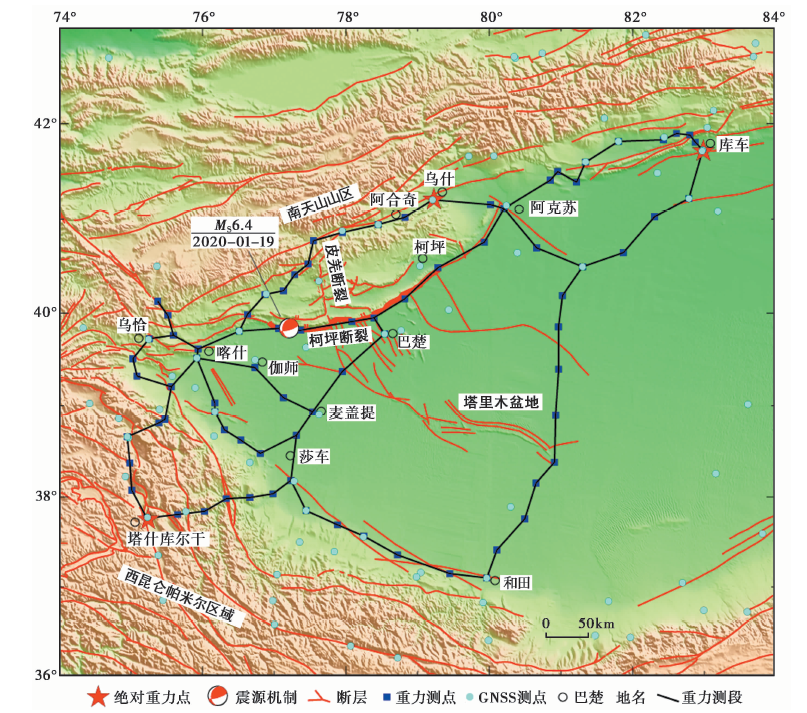
Fig. 1 Gravity survey routes, GNSS points and active faults.
| 观测时间 | 仪器型号 | 点值平均精度/m·s-2 |
|---|---|---|
| 2015-04 | CG5-207、 CG5-511 | 6.7×10⁻⁸ |
| 2016-04 | CG5-207、 CG5-511 | 6.2×10⁻⁸ |
| 2017-04 | CG5-207、 CG5-511 | 10.4×10⁻⁸ |
| 2018-04 | CG6-018、 CG6-023 | 6.9×10⁻⁸ |
| 2019-04 | CG5-216、 CG5-230 | 5.6×10⁻⁸ |
| 2020-04 | CG6-018、 CG6-023 | 6.9×10⁻⁸ |
| 2021-04 | CG6-018、 CG6-023 | 7.4×10⁻⁸ |
Table1 Information of gravity survey in Kashi-Jiashi region
| 观测时间 | 仪器型号 | 点值平均精度/m·s-2 |
|---|---|---|
| 2015-04 | CG5-207、 CG5-511 | 6.7×10⁻⁸ |
| 2016-04 | CG5-207、 CG5-511 | 6.2×10⁻⁸ |
| 2017-04 | CG5-207、 CG5-511 | 10.4×10⁻⁸ |
| 2018-04 | CG6-018、 CG6-023 | 6.9×10⁻⁸ |
| 2019-04 | CG5-216、 CG5-230 | 5.6×10⁻⁸ |
| 2020-04 | CG6-018、 CG6-023 | 6.9×10⁻⁸ |
| 2021-04 | CG6-018、 CG6-023 | 7.4×10⁻⁸ |
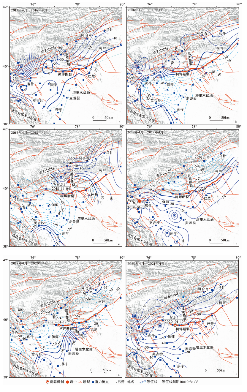
Fig. 2 Gravity field dynamic variation images in one year time scale. a 2015-042016-04; b 2016-042017-04; c 2017-042018-04; d 2018-042019-04; e 2019-042020-04; f 2020-042021-04
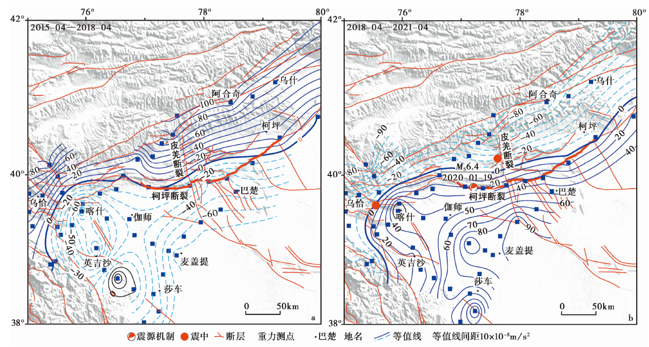
Fig. 3 Gravity field dynamic variation images. a 2015-042018-04; b 2018-042021-04
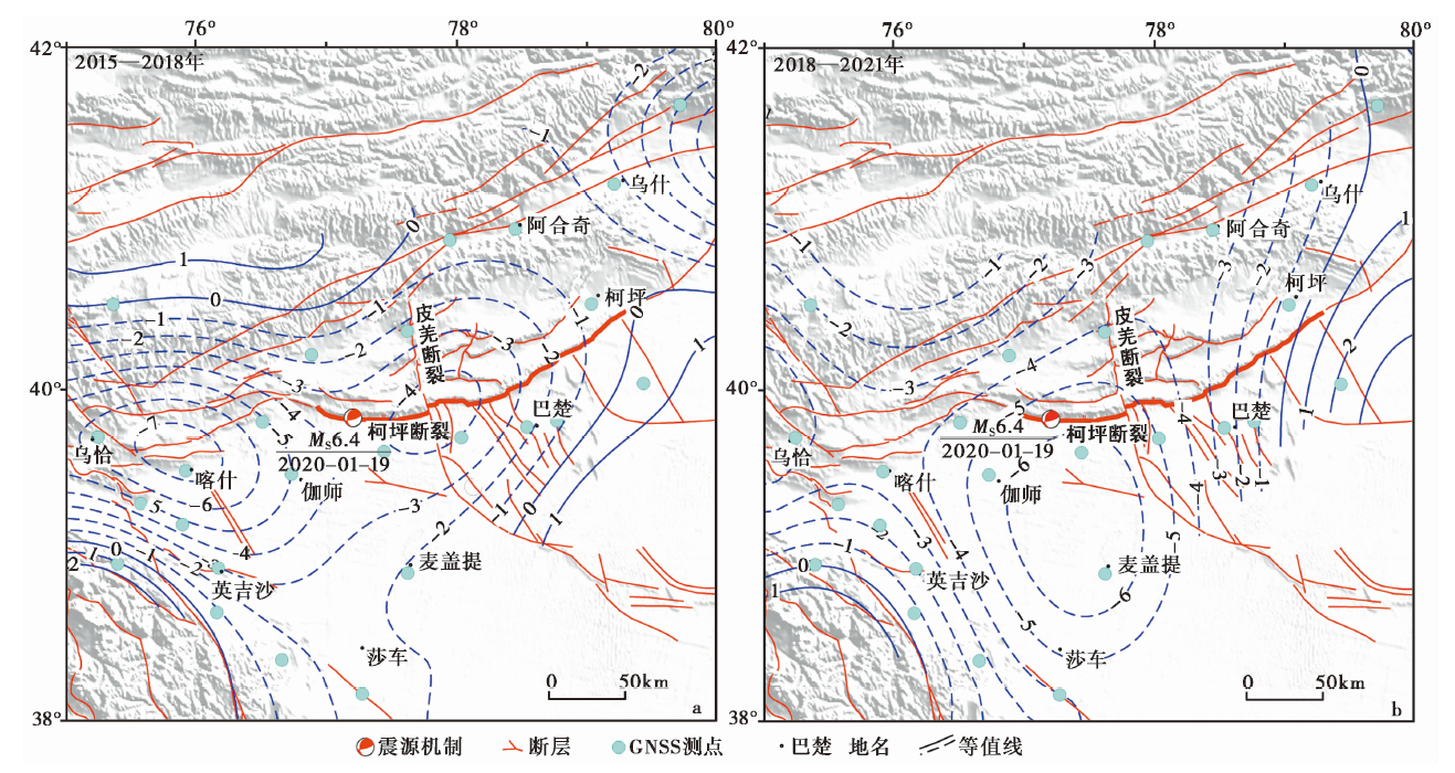
Fig. 4 Contour map of the surface expansion rate.
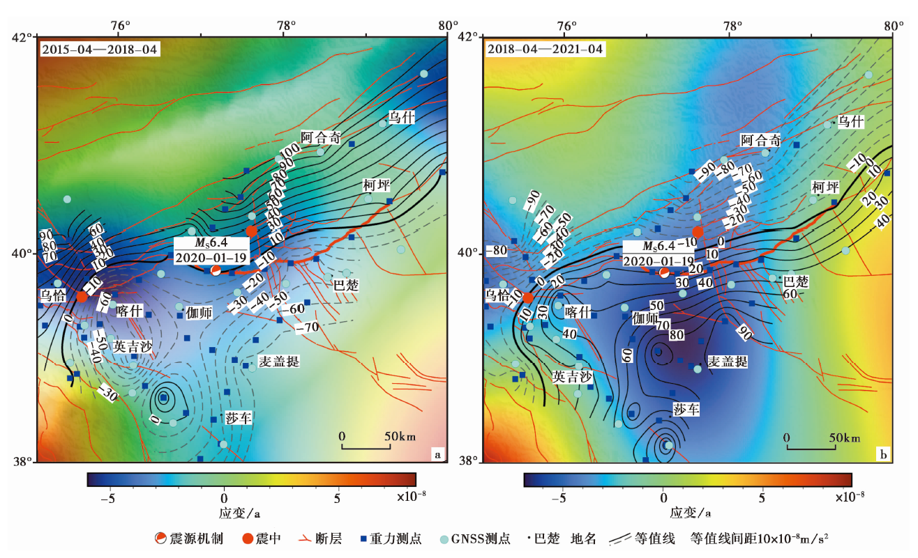
Fig. 5 Cumulative variation of gravity and surface expansion rate.
| [1] | 薄万举, 郑智江, 武艳强, 等. 2021. 精密水准与GNSS垂向形变关系研究: 以天山构造带为例[J]. 大地测量与地球动力学, 41(9): 881885. |
| BO Wan-ju, ZHENG Zhi-jiang, WU Yan-qiang, et al. 2021. Study on the relationship between GNSS vertical deformation and precision leveling vertical deformation: Take the Tianshan tectonic belt as an example[J]. Journal of Geodesy and Geodynamics, 41(9): 881885. (in Chinese) | |
| [2] | 陈石, 王谦身, 祝意青, 等. 2011. 汶川 MS8.0 震前区域重力场变化与震质中研究[J]. 地球物理学进展, 26(4): 11471156. |
| CHEN Shi, WANG Qian-shen, ZHU Yi-qing, et al. 2011. Regional gravity variation before Wenchuan MS8.0 earthquake and epicentroid research[J]. Progress in Geophysics, 26(4): 11471156. (in Chinese) | |
| [3] | 陈运泰, 顾浩鼎, 卢造勋. 1980. 1975年海城地震与1976年唐山地震前后的重力变化[J]. 地震学报, 2(1): 2131. |
| CHEN Yun-tai, GU Hao-ding, LU Zao-xun. 1980. Variations of gravity before and after the Haicheng earthquake, 1975 and the Tangshan earthquake, 1976[J]. Acta Seismologica Sinica, 2(1): 2131. (in Chinese) | |
| [4] | 陈兆辉, 张双喜, 刘金钊, 等. 2021. 地震重力网经典平差与拟稳平差综合分析与研究[J]. 武汉大学学报(信息科学版), 46(11): 16931702. |
| CHEN Zhao-hui, ZHANG Shuang-xi, LIU Jin-zhao, et al. 2021. Comprehensive analysis and research of classic adjustment and quasi-stable adjustment in mobile gravity network[J]. Geomatics and Information Science of Wuhan University, 46(11): 16931702. (in Chinese) | |
| [5] | 顾国华, 王武星. 2017. 2016年新西兰7.8级大地震GPS观测结果与弹性回跳模型[J]. 武汉大学学报(信息科学版), 42(11): 16731680. |
| GU Guo-hua, WANG Wu-xing. 2017. Results of observation for M7.8 earthquake in 2016 in New Zealand and discussion on elastic rebound mode[J]. Geomatics and Information Science of Wuhan University, 42(11): 16731680. (in Chinese) | |
| [6] | 何文渊, 李江海, 钱祥麟, 等. 2002. 塔里木盆地柯坪断隆断裂构造分析[J]. 中国地质, 29(1): 3743. |
| HE Wen-yuan, LI Jiang-hai, QIAN Xiang-lin, et al. 2002. Analysis of fault structures in the Kalpin fault uplift, Tarim Basin[J]. Geology in China, 29(1): 3743. (in Chinese) | |
| [7] | 江在森, 方颖, 武艳强, 等. 2009. 汶川8.0级地震前区域地壳运动与变形动态过程[J]. 地球物理学报, 52(2): 505518. |
| JIANG Zai-sen, FANG Yin, WU Yan-qiang, et al. 2009. The dynamic process of regional crustal movement and deformation before Wenchuan MS8.0 earthquake[J]. Chinese Journal of Geophysics, 52(2): 505518. (in Chinese) | |
| [8] | 江在森, 武艳强, 邹镇宇, 等. 2020. GNSS在中国大陆的地震预测应用研究进展与展望[J]. 中国地震, 36(4): 693707. |
| JIANG Zai-sen, WU Yan-qiang, ZOU Zhen-yu, et al. 2020. Progress and prospect of earthquake forecasting based on GNSS data in China[J]. Earthquake Research in China, 36(4): 693707. (in Chinese) | |
| [9] |
李安, 冉勇康, 刘华国, 等. 2016. 西南天山柯坪推覆系西段全新世构造活动特征和古地震[J]. 地球科学进展, 31(4): 377390.
DOI |
|
LI An, RAN Yong-kang, LIU Hua-guo, et al. 2016. Active characteristics and paleoearthquakes in the west Kalpin nappe since the Holocene, SW Tianshan Mountain[J]. Advances in Earth Science, 31(4): 377390. (in Chinese)
DOI |
|
| [10] | 李辉, 申重阳, 孙少安, 等. 2009. 中国大陆近期重力场动态变化图像[J]. 大地测量与地球动力学, 29(3): 110. |
| LI Hui, SHEN Chong-yang, SUN Shao-an, et al. 2009. Dynamic gravity change in recent years in China continent[J]. Journal of Geodesy and Geodynamics, 29(3): 110. (in Chinese) | |
| [11] | 闵伟, 宋方敏, 韩竹军, 等. 2006. 柯坪塔格断裂西段古地震初步研究[J]. 地震地质, 28(2): 234244. |
| MIN Wei, SONG Fang-min, HAN Zhu-jun, et al. 2006. The preliminary study on paleoearthquakes along the western segment of Kalpintag Fault[J]. Seismology and Geology, 28(2): 234244. (in Chinese) | |
| [12] | 倪清, 褚永海. 2016. 连续曲率张力样条方法在测高数据格网化中的应用[J]. 测绘地理信息, 41(2): 2628, 53. |
| NI Qing, CHU Yong-hai. 2016. Continuous curvature splines in tension applied for gridding satellite altimetry data[J]. Journal of Geomatics, 41(2): 2628, 53. (in Chinese) | |
| [13] | 乔学军, 聂兆生, 杨少敏, 等. 2011. GPS与InSAR揭示喀什坳陷及邻区的垂直运动与构造特征[J]. 大地测量与地球动力学, 31(3): 17. |
| QIAO Xue-jun, NIE Zhao-sheng, YANG Shao-min, et al. 2011. Study on crustal deformation in Kashi depression and neighboring region of Pamir and Tianshan by GPS and InSAR[J]. Journal of Geodesy and Geodynamics, 31(3): 17. (in Chinese) | |
| [14] | 冉勇康, 杨晓平, 徐锡伟, 等. 2006. 西南天山柯坪推覆构造东段晚第四纪变形样式与缩短速率[J]. 地震地质, 28(2): 179193. |
| RAN Yong-kang, YANG Xiao-ping, XU Xi-wei, et al. 2006. Deformation pattern and shortening rates in the east part of Kalpin thrust system in southwest Tianshan during late Quaternary[J]. Seismology and Geology, 28(2): 179193. (in Chinese) | |
| [15] | 申重阳, 李辉, 付广裕. 2003. 丽江7.0级地震重力前兆模式研究[J]. 地震学报, 25(2): 163171, 228. |
| SHEN Chong-yang, LI Hui, FU Guang-yu. 2003. Study on gravity precursor mode of Lijiang earthquake with MS=7.0[J]. Acta Seismologica Sinica, 25(2): 163171, 228. (in Chinese) | |
| [16] | 申重阳, 李辉, 孙少安, 等. 2009. 重力场动态变化与汶川 MS8.0 地震孕育过程[J]. 地球物理学报, 52(10): 25472557. |
| SHEN Chong-yang, LI Hui, SUN Shao-an, et al. 2009. Dynamic variations of gravity and the preparation process of the Wenchuan MS8.0 earthquake[J]. Chinese Journal of Geophysics, 52(10): 25472557. (in Chinese) | |
| [17] | 申重阳, 谈洪波, 郝洪涛, 等. 2011. 2009年姚安 MS6.0 地震重力场前兆变化机理[J]. 大地测量与地球动力学, 31(2): 1722, 47. |
| SHEN Chong-yang, TAN Hong-bo, HAO Hong-tao, et al. 2011. Mechanism of precursory gravity change before Yaoan MS6.0 earthquake in 2009[J]. Journal of Geodesy and Geodynamics, 31(2): 1722, 47. (in Chinese) | |
| [18] | 孙建中, 杨少敏. 2005. 用GPS资料揭示现今中国大陆构造运动[J]. 大地测量与地球动力学, 25(3): 7580. |
| SUN Jian-zhong, YANG Shao-min. 2005. Tectonic movement of Chinese mainland revealed from GPS data[J]. Journal of Geodesy and Geodynamics, 25(3): 7580. (in Chinese) | |
| [19] | 王琪, 丁国瑜, 乔学军, 等. 2000. 天山现今地壳快速缩短与南北地块的相对运动[J]. 科学通报, 45(14): 15431547. |
| WAN Qi, DING Guo-yu, QIAO Xue-jun, et al. 2000. Recent rapid shortening of crust across the Tianshan Mts. and relative motion of tectonic blocks in the north and south[J]. Chinese Science Bulletin, 45(14): 15431547. (in Chinese) | |
| [20] | 王琪, 张培震, 牛之俊, 等. 2001. 中国大陆现今地壳运动和构造变形[J]. 中国科学(D辑), 31(7): 529536. |
| WAN Qi, ZHANG Pei-zhen, NIU Zhi-jun, et al. 2001. Crustal movement and tectonic deformation in Chinese mainland[J]. Science in China(Ser D), 31(7): 529536. (in Chinese) | |
| [21] | 王晓强, 路星, 刘斌, 等. 2009. 新疆地区现今地壳垂直运动及地震活动研究[J]. 大地测量与地球动力学, 29(6): 2227, 31. |
| WANG Xiao-qiang, LU Xing, LIU Bin, et al. 2009. Study on present-day vertical crust movement and seismic activity in Xinjiang area[J]. Journal of Geodesy and Geodynamics, 29(6): 2227, 31. (in Chinese) | |
| [22] | 武艳强, 江在森, 杨国华, 等. 2009. 利用最小二乘配置在球面上整体解算GPS应变场的方法及应用[J]. 地球物理学报, 52(7): 17071714. |
| WU Yan-qiang, JIANG Zai-sen, YANG Guo-hua, et al. 2009. The application and method of GPS strain calculation in whole mode using least square collocation in sphere surface[J]. Chinese Journal of Geophysics, 52(7): 17071714. (in Chinese) | |
| [23] | 武艳强, 江在森, 朱爽, 等. 2020. 中国大陆西部GNSS变形特征及其与M≥7.0强震孕育的关系[J]. 中国地震, 36(4): 756766. |
| WU Yan-qiang, JIANG Zai-sen, ZHU Shuang, et al. 2020. GNSS deformation characteristics and its relationship with M≥7.0 strong earthquake in western China[J]. Earthquake Research in China, 36(4): 756766. (in Chinese) | |
| [24] | 杨晓平, 冉勇康, 程建武, 等. 2006. 柯坪推覆构造中的几个新生褶皱带阶地变形测量与地壳缩短[J]. 中国科学(D辑), 36(10): 905913. |
| YANG Xiao-ping, RAN Yong-kang, CHENG Jian-wu, et al. 2006. Terrace deformation measurement and crustal shortening of several new fold belts in Keping nappe structure[J]. Science in China (Ser D), 36(10): 905913. (in Chinese) | |
| [25] | 张国民, 马宏生, 王辉, 等. 2005. 中国大陆活动地块边界带与强震活动[J]. 地球物理学报, 48(3): 602610. |
|
ZHANG Guo-min, MA Hong-sheng, WANG Hui, et al. 2005. Boundaries between active-tectonic block and strong earthquakes in the China mainland[J]. Chinese Journal of Geophysics, 48(3): 602610. (in Chinese)
DOI URL |
|
| [26] | 张晶, 武艳强, 刘琦, 等. 2013. GPS水平形变面应变率梯度与强震危险区关系探讨[J]. 地震学报, 35(6): 828835. |
| ZHANG Jing, WU Yan-qiang, LIU Qi, et al. 2013. Relationship between plane strain rate gradient of GPS horizontal deformation and strong earthquake risk area[J]. Acta Seismologica Sinica, 35(6): 828835. (in Chinese) | |
| [27] | 张希, 江在森, 张四新. 1998. 借助最小二乘配置整体解算地壳视应变场[J]. 地壳形变与地震, 18(2): 5762. |
| ZHANG Xi, JIANG Zai-sen, ZHANG Si-xin. 1998. Whole calculation of the crustal visual strain field with the least square collocation[J]. Crustal Deformation and Earthquake, 18(2): 5762. (in Chinese) | |
| [28] | 祝意青, 李铁明, 郝明, 等. 2016. 2016年青海门源 MS6.4 地震前重力变化[J]. 地球物理学报, 59(10): 37443752. |
| ZHU Yi-qing, LI Tie-ming, HAO Ming, et al. 2016. Gravity changes before the Menyuan, Qinghai MS6.4 earthquake of 2016[J]. Chinese Journal of Geophysics, 59(10): 37443752. (in Chinese) | |
| [29] | 祝意青, 梁伟锋, 湛飞并, 等. 2012. 中国大陆重力场动态变化研究[J]. 地球物理学报, 55(3): 804813. |
| ZHU Yi-qing, LIANG Wei-feng, ZHAN Fei-bing, et al. 2012. Study on dynamic change of gravity field in China continent[J]. Chinese Journal of Geophysics, 55(3): 804813. (in Chinese) | |
| [30] | 祝意青, 梁伟锋, 赵云峰, 等. 2017. 2017年四川九寨沟 MS7.0 地震前区域重力场变化[J]. 地球物理学报, 60(10): 41244131. |
| ZHU Yi-qing, LIANG Wei-feng, ZHAO Yun-feng, et al. 2017. Gravity changes before the Jiuzhaigou, Sichuan, MS7.0 earthquake of 2017[J]. Chinese Journal of Geophysics, 60(10): 41244131. (in Chinese) | |
| [31] | 祝意青, 刘芳, 郭树松. 2011. 2010年玉树 MS7.1 地震前的重力变化[J]. 大地测量与地球动力学, 31(1): 14, 8. |
| ZHU Yi-qing, LIU Fang, GUO Shu-song. 2011. Gravity change before the Yushu MS7.1 earthquake in 2010[J]. Journal of Geodesy and Geodynamics, 31(1): 14, 8. (in Chinese) | |
| [32] | 祝意青, 刘芳, 李铁明, 等. 2015. 川滇地区重力场动态变化及其强震危险含义[J]. 地球物理学报, 58(11): 41874196. |
| ZHU Yi-qing, LIU Fang, LI Tie-ming, et al. 2015. Dynamic variation of the gravity field in the Sichuan-Yunnan region and its implication for seismic risk[J]. Chinese Journal of Geophysics, 58(11): 41874196. (in Chinese) | |
| [33] | 祝意青, 闻学泽, 孙和平, 等. 2013. 2013年四川芦山 MS7.0 地震前的重力变化[J]. 地球物理学报, 56(6): 18871894. |
| ZHU Yi-qing, WEN Xue-ze, SUN He-ping, et al. 2013. Gravity changes before the Lushan, Sichuan, MS=7.0 earthquake of 2013[J]. Chinese Journal of Geophysics, 56(6): 18871894. (in Chinese) | |
| [34] | 祝意青, 徐云马, 吕弋培, 等. 2009. 龙门山断裂带重力变化与汶川8.0级地震关系研究[J]. 地球物理学报, 52(10): 25382546. |
| ZHU Yi-qing, XU Yu-ma, LÜ Yi-pei, et al. 2009. Relation between gravity variation of Longmenshan fault zone and Wenchuan MS8.0 earthquake[J]. Chinese Journal of Geophysics, 52(10): 25382546. (in Chinese) | |
| [35] | 朱治国, 艾力夏提·玉山, 刘代芹, 等. 2017. 西天山地区重力场变化与地震研究[J]. 大地测量与地球动力学, 37(9): 903907. |
| ZHU Zhi-guo, HUSAN Irxat, LIU Dai-qin, et al. 2017. Variation of gravity field and earthquake in the west Tianshan area[J]. Journal of Geodesy and Geodynamics, 37(9): 903907. (in Chinese) | |
| [36] | 朱治国, 秦珊兰, 李煜航, 等. 2016. 利用GNSS资料研究新源-和静 MS6.6 地震前后地壳形变与地震关系[J]. 地震工程学报, 38(3): 407412, 430. |
| ZHU Zhi-guo, QIN Shan-lan, LI Yu-hang, et al. 2016. Relationship between crustal deformation and earthquake activities before and after the Xinyuan-Hejing MS6.6 earthquake using GNSS data[J]. China Earthquake Engineering Journal, 38(3): 407412, 430. (in Chinese) | |
| [37] |
Avouac J P, Tapponnier P. 1993. Kinematic model of active deformation in central Asia[J]. Geophysical Research Letters, 20(10): 895898.
DOI URL |
| [38] |
Lei J, Zhao D. 2007. Teleseismic P-wave tomography and the upper mantle structure of the central Tien Shan orogenic belt[J]. Physics of the Earth and Planetary Interiors: A Journal Devoted to Observational and Experimental Studies of the Chemistry and Physics of Planetary Interiors and Their Theoretical Interpretation, 162(3-4): 165185. doi.org/10.1016/j.pepi.2007.04.010.
DOI |
| [39] |
Li W, Chen Y, Yuan X H, et al. 2022. Intracontinental deformation of the Tianshan Orogen in response to India-Asia collision[J]. Nature Communications, 13(3738). doi.10.1038/s41467-022-30795-6.
DOI |
| [40] |
Li Z W, Steve R, Li Z H, et al. 2009. Tomographic image of the crust and upper mantle beneath the western Tien Shan from the MANAS broadband deployment: Possible evidence for lithospheric delamination[J]. Tectonophysics, 477(1-2): 4957. doi.10.1016/j.tecto.2009.05.007.
DOI URL |
| [41] |
Smith W H F, Wessel P. 1990. Gridding with continuous curvature splines in tension[J]. Geophysics, 55(3): 293305. doi.org/10.1190/1.1442837.
DOI URL |
| [1] | ZHANG Wen-liang, LI Ying, LIU Zhao-fei, HU Le, LU Chang, CHEN Zhi, HAN Xiao-kun. SPATIAL DISTRIBUTION CHARACTERISTICS OF SOIL GAS HE CONCENTRATION IN THE EASTERN LIUPANSHAN FAULT ZONE AND ITS RELATIONSHIP WITH TECTONIC ACTIVITY [J]. SEISMOLOGY AND GEOLOGY, 2023, 45(3): 753-771. |
| [2] | LI Zhao, FU Bi-hong. QUANTITATIVE ANALYSES OF GEOMORPHOLOGIC FEATURES IN RESPONSE TO LATE QUATERNARY TECTONIC ACTI-VITIES ALONG THE MAQIN-MAQU SEGMENT, EAST KUNLUN FAULT ZONE [J]. SEISMOLOGY AND GEOLOGY, 2022, 44(6): 1421-1447. |
| [3] | LI Jing-wei, CHEN Chang-yun, ZHAN Wei, WU Yan-qiang. RESEARCH ON FAST ACQUISITION OF GNSS COSEISMIC HORIZONTAL DISPLACEMENT OF MADUO MS7.4 EARTHQUAKE IN QINGHAI PROVINCE [J]. SEISMOLOGY AND EGOLOGY, 2021, 43(5): 1073-1084. |
| [4] | ZHOU Yun, PAN Zheng-yang, WANG Wei-min, HE Jian-kun, WANG Xun, LI Guo-hui. RELATIONSHIP BETWEEN STRESS INTERACTION AND STRONG EARTHQUAKE ACTIVITY OF JIASHI EARTHQUAKES (MW≥6.0)SINCE 1998 [J]. SEISMOLOGY AND GEOLOGY, 2021, 43(2): 280-296. |
| [5] | LIU Dai-qin, CHEN Shi, WANG Xiao-qiang, ZHANG Bei, LI Jie, WU Chuan-yong, LU Hong-yan. THE APPARENT DENSITY VARIATION OF THE FOCAL AREA BEFORE AND AFTER JIASHI MS6.4 EARTHQUAKE AND ITS TECTONIC SIGNIFICANCE [J]. SEISMOLOGY AND GEOLOGY, 2021, 43(2): 311-328. |
| [6] | GUO Zhi, GAO Xing, LU Zhen. RELOCATION AND FOCAL MECHANISM FOR THE XINJIANG JIASHI EARTHQUAKE ON 19 JANUARY, 2020 [J]. SEISMOLOGY AND GEOLOGY, 2021, 43(2): 345-356. |
| [7] | ZHANG Wen-ting, JI Ling-yun, ZHU Liang-yu, JIANG Feng-yun, XU Xiao-xue. A TYPICAL THRUST RUPTURE EVENT OCCURRING IN THE FORELAND BASIN OF THE SOUTHERN TIANSHAN: THE 2020 XINJIANG JIASHI MS6.4 EARTHQUAKE [J]. SEISMOLOGY AND GEOLOGY, 2021, 43(2): 394-409. |
| [8] | YAO Yuan, LI Tao, LIU Qi, DI Ning. CHARACTERISTICS OF GEOLOGICAL HAZARDS IN THE EPICENTER OF THE JIASHI MW6.0 EARTHQUAKE ON JANUARY 19, 2020 [J]. SEISMOLOGY AND GEOLOGY, 2021, 43(2): 410-429. |
| [9] | CHEN Shun-yun, SONG Chun-yan, YAN Wei, LIU Qiong-ying, LIU Pei-xun, ZHUO Yan-qun, ZHANG Zhi-he. CHANGE IN BEDROCK TEMPERATURE BEFORE AND AFTER JIASHI MS6.4 EARTHQUAKE IN XINJIANG ON JANUARY 19, 2020 [J]. SEISMOLOGY AND GEOLOGY, 2021, 43(2): 447-458. |
| [10] | HAO Ming, WANG Qing-liang. PROGRESS IN APPLICATION OF GNSS TO DIVISION OF ACTIVE TECTONIC BLOCKS IN CONTINENTAL CHINA [J]. SEISMOLOGY AND GEOLOGY, 2020, 42(2): 283-296. |
| [11] | WEN Xiang, ZHOU Bin, SHI Shui-ping, QIN Jian, LI Jia-ning, HE Yan, YAN Chun-heng, LUO Yuan-peng. COMPREHENSIVE ANALYSIS OF RECENT GRAVITY AND CRUSTAL DEFORMATION IN NORTHWESTERN GUANGXI [J]. SEISMOLOGY AND GEOLOGY, 2019, 41(4): 927-943. |
| [12] | XIONG Cheng, XIE Zu-jun, ZHENG Yong, XIONG Xiong, AI San-xi, XIE Ren-xian. RAYLEIGH WAVE TOMOGRAPHY IN THE CRUST AND UPPER MANTLE OF THE DABIE-TANLU OROGENIC ZONE [J]. SEISMOLOGY AND GEOLOGY, 2019, 41(1): 1-20. |
| [13] | LI Tie-ming, XU Yun-ma, YANG Yong-lin, FENG Sheng-tao. STUDY ON DYNAMIC CHANGE OF GRAVITY FIELD IN XIANSHUIHE FAULT ZONE AND THEIR RELATION TO THE OCCURRENCE OF MS ≥ 5.0 EARTHQUAKES [J]. SEISMOLOGY AND GEOLOGY, 2018, 40(6): 1362-1379. |
| [14] | XU Wei, LIU Zhi-cheng, YUAN Zhao-de, GAO Zhan-wu, YANG Yuan-yuan. RIVER GEOMORPHIC PARAMETERS OF THE HUASHAN PIEDMONT AND THEIR TECTONIC IMPLICATIONS [J]. SEISMOLOGY AND GEOLOGY, 2017, 39(6): 1316-1335. |
| [15] | GAO Shuai-po, RAN Yong-kang, WU Fu-yao, XU Liang-xin, WANG Hu, LIANG Ming-jian. USING UAV PHOTOGRAMMETRY TECHNOLOGY TO EXTRACT INFORMATION OF TECTONIC ACTIVITY OF COMPLEX ALLUVIAL FAN——A CASE STUDY OF AN ALLUVIAL FAN IN THE SOUTHERN MARGIN OF BARKOL BASIN [J]. SEISMOLOGY AND GEOLOGY, 2017, 39(4): 793-804. |
| Viewed | ||||||
|
Full text |
|
|||||
|
Abstract |
|
|||||
