SEISMOLOGY AND GEOLOGY ›› 2023, Vol. 45 ›› Issue (5): 1057-1073.DOI: 10.3969/j.issn.0253-4967.2023.05.002
Previous Articles Next Articles
YOU Zi-cheng1)( ), BI Hai-yun1),*(), ZHENG Wen-jun2), PENG Hui2), LIANG Shu-min2), DUAN Lei2), QIN Yi-gen2)
Received:2022-10-27
Revised:2023-03-14
Online:2023-10-20
Published:2023-11-23
游子成1)(), 毕海芸1),*(), 郑文俊2), 彭慧2), 梁淑敏2), 段磊2), 覃乙根2)
通讯作者:
毕海芸, 女, 1988年生, 研究员, 硕士生导师, 主要研究方向为活动构造与构造地貌, E-mail: 作者简介:游子成, 男, 1997年生, 现为中国地震局地质研究所构造地质学专业在读硕士研究生, 主要从事活动构造与构造地貌方面的研究, E-mail: youzicheng97@163.com。
基金资助:YOU Zi-cheng, BI Hai-yun, ZHENG Wen-jun, PENG Hui, LIANG Shu-min, DUAN Lei, QIN Yi-gen. FINE CHARACTERISTICS OF EARTHQUAKE SURFACE RUPTURE ZONE BASED ON HIGH-RESOLUTION REMOTE SENSING IMAGE: A CASE STUDY OF LITANG FAULT[J]. SEISMOLOGY AND GEOLOGY, 2023, 45(5): 1057-1073.
游子成, 毕海芸, 郑文俊, 彭慧, 梁淑敏, 段磊, 覃乙根. 基于高分辨率遥感影像的地震破裂带精细特征研究——以理塘断裂为例[J]. 地震地质, 2023, 45(5): 1057-1073.
Add to citation manager EndNote|Ris|BibTeX
URL: https://www.dzdz.ac.cn/EN/10.3969/j.issn.0253-4967.2023.05.002

Fig. 1 Regional tectonic location of the Litang fault zone.

Fig. 2 Spatial geometric distribution of the Litang fault zone.
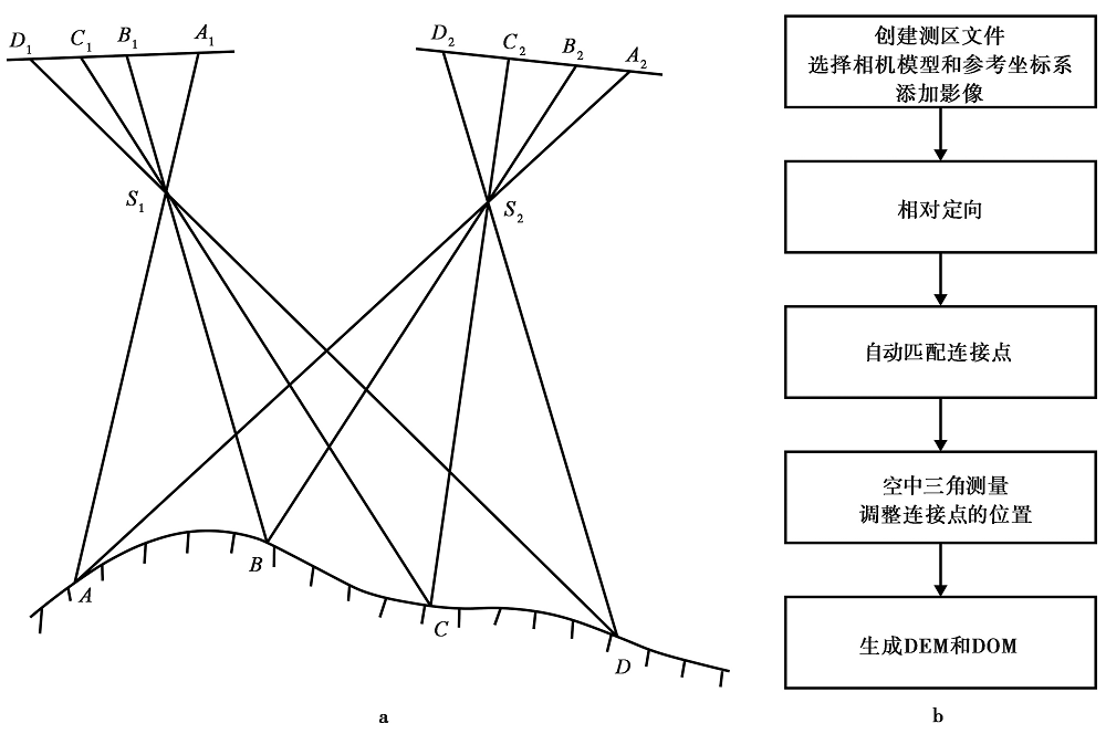
Fig. 3 Basic principle(a)and processing flow(b)of photogrammetry(modified from ZHANG Jian-qing et al., 2003).
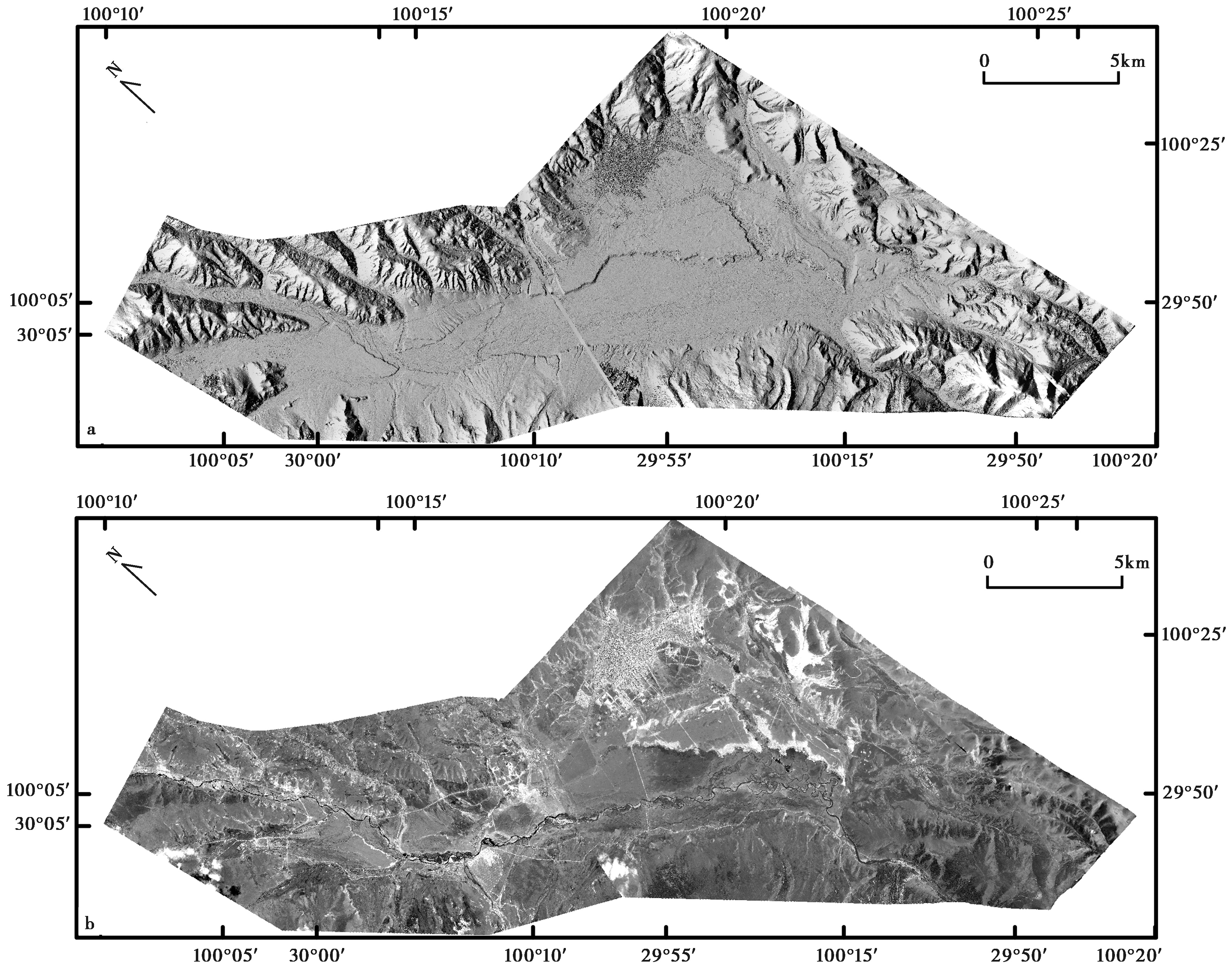
Fig. 4 Digital elevation model(a)and orthophoto(b)of Litang Fault based on photogrammetry.

Fig. 5 Spatial geometric distribution of surface rupture zone of the Litang Fault.

Fig. 6 Typical surface rupture traces of the Litang Fault.
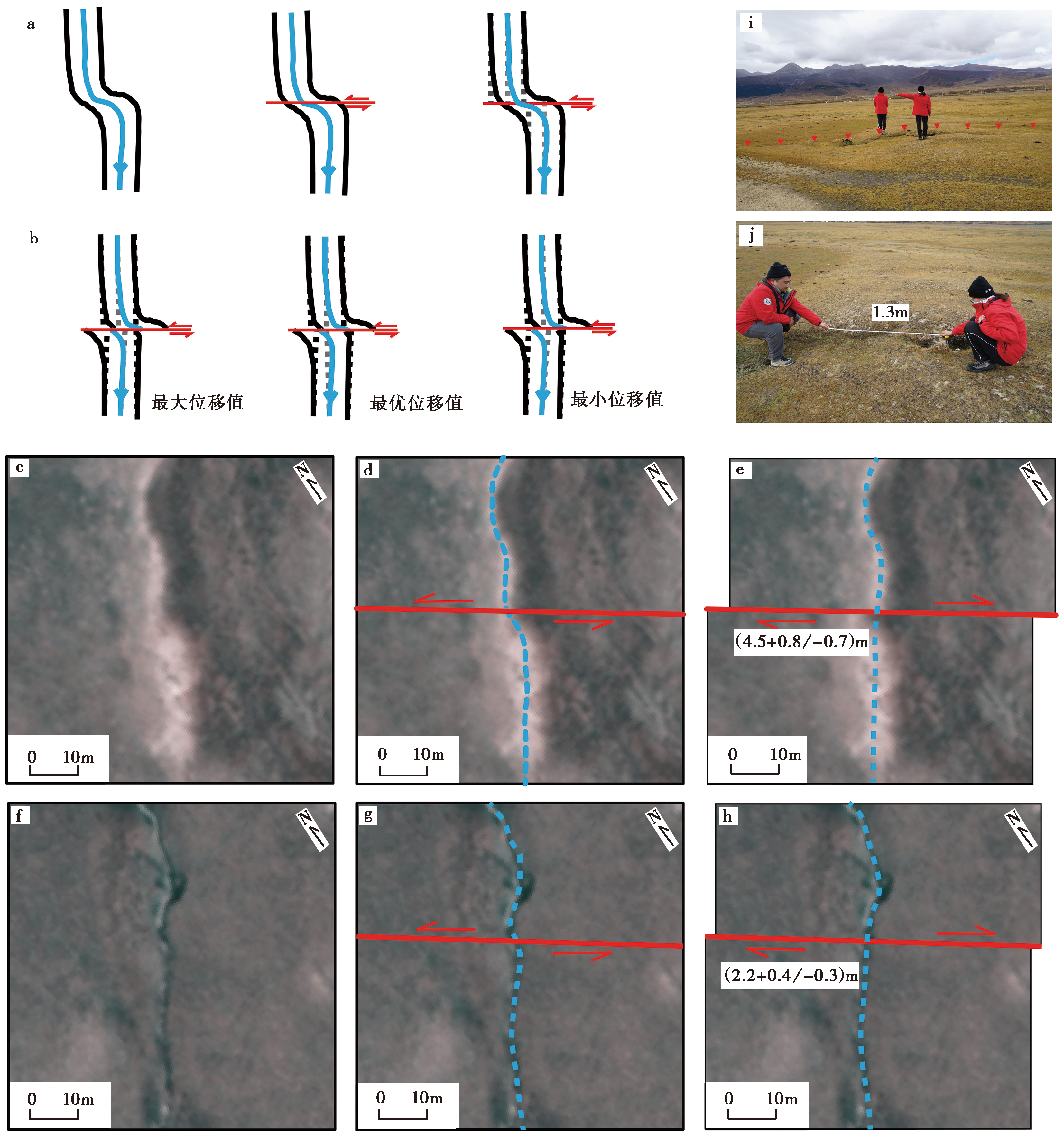
Fig. 7 Principal diagram of horizontal offset measurement.
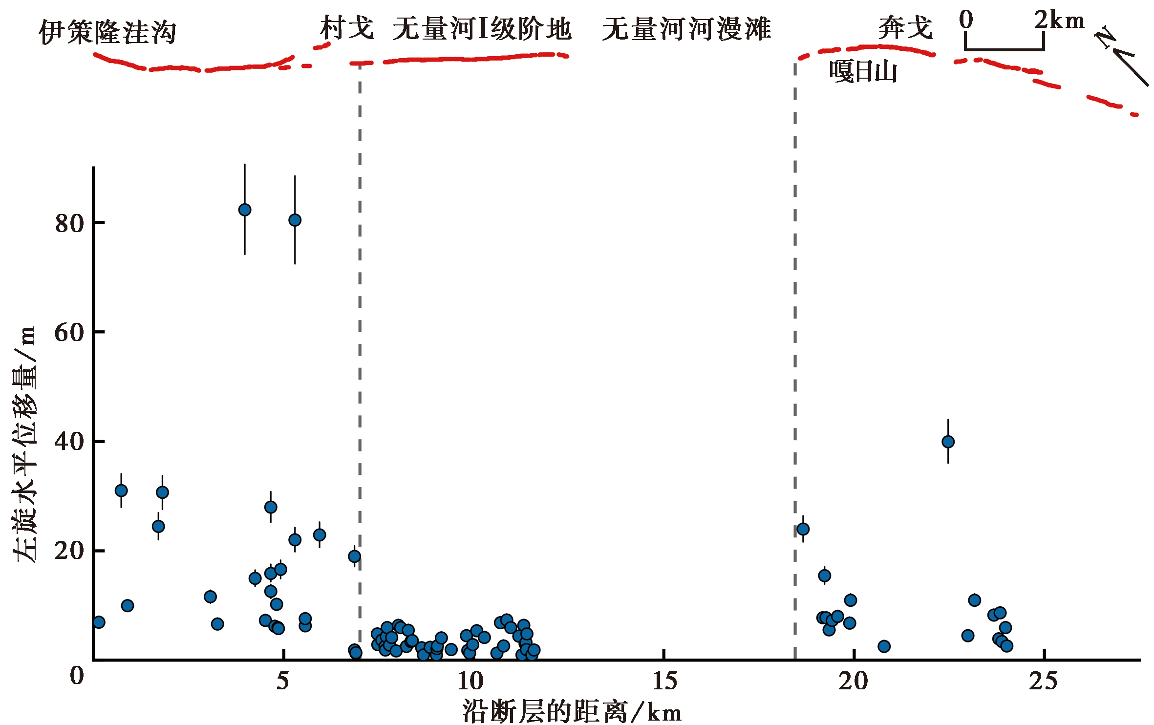
Fig. 8 Horizontal offset distribution along the Litang Fault.
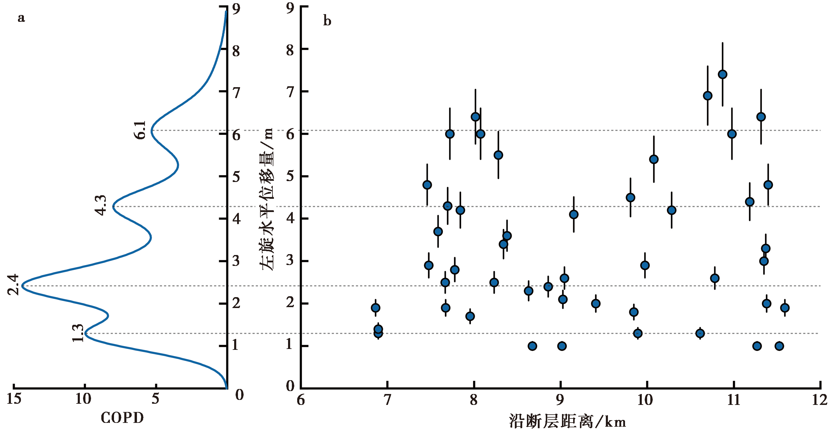
Fig. 9 Cumulative Offset Probability Distribution(COPD)(a)of the horizontal offsets(b) on the terrace I of the Wuliang River.
| [1] |
陈桂华, 李忠武, 徐锡伟, 等. 2022. 2021年青海玛多M7.4地震发震断裂的典型同震地表变形与晚第四纪断错累积及其区域构造意义[J]. 地球物理学报, 65(8): 2984—3005.
|
|
|
|
| [2] |
邓起东, 于贵华, 叶文华. 1992. 地震地表破裂参数与震级关系的研究 [G]// 国家地震局地质研究所. 活动断裂研究理论与应用(2). 北京: 地震出版社: 247—264.
|
|
|
|
| [3] |
邓起东, 张培震, 冉勇康, 等. 2002. 中国活动构造基本特征[J]. 中国科学(D辑), 32(12): 1020—1030.
|
|
|
|
| [4] |
丁辉, 姚安强. 2012. 利用IKONOS立体像对提取DEM精度的实验[J]. 测绘科学, 37(1): 179—181.
|
|
|
|
| [5] |
黄彩权. 1983. 1948年理塘7¼级地震的发震断裂及地震破裂带特征[J]. 四川地震, (2): 1—3.
|
|
|
|
| [6] |
江娃利. 2008. 试论地质学者的地震理念[J]. 地震地质, 30(1): 305—323.
|
|
|
|
| [7] |
姜文亮, 张景发, 申旭辉, 等. 2018. 高分辨率遥感技术在活动断层研究中的应用[J]. 遥感学报, 22(S1): 192—211.
|
|
|
|
| [8] |
李海兵, 潘家伟, 孙知明, 等. 2015. 2014 年于田 MS7.3 地震地表破裂特征及其发震构造[J]. 地质学报, 89(1): 180—194.
|
|
DOI URL |
|
| [9] |
梁子晗, 魏占玉, 庄其天, 等. 2021. 基于高分辨率地形数据的富蕴M8.0地震地表破裂带精细特征[J]. 地震地质, 43(6): 1507—1523.
|
|
|
|
| [10] |
刘静, 陈涛, 张培震, 等. 2013. 机载激光雷达扫描揭示海原断裂带微地貌的精细结构[J]. 科学通报, 58(1): 41—45.
|
|
|
|
| [11] |
刘亢, 李岩峰, 郭辉文, 等. 2021. 1948年川西理塘M7.3地震地表破裂特征及Riedel剪切构造分析[J]. 地质学报, 95(8): 2346—2360.
|
|
|
|
| [12] |
马丹, 吴中海, 李家存, 等. 2014. 川西理塘断裂带的空间展布与第四纪左旋走滑活动的遥感影像标志[J]. 地质学报, 88(8): 1417—1435.
|
|
|
|
| [13] |
马冀, 冯希杰, 李高阳, 等. 2016. 1556年华县地震地表破裂带同震垂直位移[J]. 地震地质, 38(1): 22—30.
|
|
|
|
| [14] |
冉洪流. 2011. 中国西部走滑型活动断裂的地震破裂参数与震级的经验关系[J]. 地震地质, 33(3): 577—585.
|
|
|
|
| [15] |
冉勇康, 李彦宝, 杜鹏, 等. 2014. 中国大陆古地震研究的关键技术与案例解析(3): 正断层破裂特征、 环境影响与古地震识别[J]. 地震地质, 36(2): 287—301. doi: 10.3969/j.issn.0253-4967.2014.02.001.
|
|
|
|
| [16] |
四川地震资料汇编编辑组. 1980. 四川地震资料汇编(一)[M]. 成都: 四川人民出版社.
|
|
Editorial Team of the Compilation of Earthquake in Sichuan Province. 1980. Compilation of Earthquakes in Sichuan Province(1)[M]. Sichuan People's Publishing House, Chengdu. (in Chinese)
|
|
| [17] |
汪思妤, 艾明, 吴传勇, 等. 2018. 高分辨率卫星影像提取DEM技术在活动构造定量研究中的应用: 以库米什盆地南缘断裂陡坎为例[J]. 地震地质, 40(5): 999—1017. doi: 10.3969/j.issn.0253-4967.2018.05.004.
|
|
|
|
| [18] |
王阎昭, 王恩宁, 沈正康, 等. 2008. 基于GPS资料约束反演川滇地区主要断裂现今活动速率[J]. 中国科学(D辑), 38(5): 582—597.
|
|
DOI URL |
|
| [19] |
魏永明, 李剑南, 陈玉, 等. 2021. 不同类型发震断层的同震地表破裂光学遥感特征研究[J]. 第四纪研究, 41(6): 1513—1531.
|
|
|
|
| [20] |
徐杰. 1979. 四川理塘强震区的地震地质特征[A]// 国家地震局西南烈度队编. 川滇强震区地震地质调查汇编. 北京: 地震出版社: 85—91.
|
|
|
|
| [21] |
徐锡伟, 闻学泽, 叶建青, 等. 2008. 汶川 MS8.0 地震地表破裂带及其发震构造[J]. 地震地质, 30(3): 597—629.
|
|
|
|
| [22] |
徐锡伟, 闻学泽, 于贵华, 等. 2005. 川西理塘断裂带平均滑动速率、 地震破裂分段与复发特征[J]. 中国科学(D辑), 35(6): 540—551.
|
|
|
|
| [23] |
徐锡伟, 闻学泽, 郑荣章, 等. 2003. 川滇地区活动块体最新构造变动样式及其动力来源[J]. 中国科学(D辑), 33(S1): 151—162.
|
|
|
|
| [24] |
于贵华, 徐锡伟,
|
|
|
|
| [25] |
张成龙, 李振洪, 张双成, 等. 2022. 综合遥感解译2022年 MW6.7 青海门源地震地表破裂带[J]. 武汉大学学报(信息科学版), 47(8): 1257—1270.
|
|
|
|
| [26] |
张剑清, 潘励, 王树根. 2003. 摄影测量学[M]. 武汉: 武汉大学出版社.
|
|
|
|
| [27] |
张克旗, 吴中海, 周春景, 等. 2020. 川西理塘断裂带奔戈—村戈段古地震事件及其非均匀性活动特征[J]. 地质学报, 94(4): 1295—1303.
|
|
|
|
| [28] |
张祖勋, 张剑清. 2012. 数字摄影测量学[M]. 武汉: 武汉大学出版社.
|
|
|
|
| [29] |
中央地震工作小组办公室. 1971. 中国地震目录(第一、 第二合订)[M]. 北京: 科学出版社:320—321.
|
|
Office of Central Earthquake Working Group. 1971. China Earthquake Catalogue(1-2)[M]. Science Press, Beijing: 320—321. (in Chinese)
|
|
| [30] |
周春景, 吴中海, 张克旗, 等. 2015. 川西理塘活动断裂最新同震地表破裂形成时代与震级的重新厘定[J]. 地震地质, 37(2): 455—467. doi: 10.3969/j.issn.0253-4967.2015.02.009.
|
|
|
|
| [31] |
周荣军, 陈国星, 李勇, 等. 2005. 四川西部理塘—巴塘地区的活动断裂与1989年巴塘6.7级震群发震构造研究[J]. 地震地质, 27(1): 31—43.
|
|
|
|
| [32] |
DOI URL |
| [33] |
|
| [34] |
DOI URL |
| [35] |
|
| [36] |
DOI |
| [37] |
|
| [38] |
|
| [39] |
DOI URL |
| [40] |
DOI URL |
| [41] |
DOI |
| [42] |
DOI URL |
| [43] |
DOI URL |
| [44] |
DOI PMID |
| [1] | SHEN Hua-liang, YANG Yao, ZHOU Zhi-hua, RUI Xue-lian, LIAO Xiao-feng, ZHAO De-yang, LIANG Ming-jian, CHEN Meng-die, GUAN Zhi-jun, REN Hong-wei. GENESIS AND DEEP GEOTHERMAL PROCESS OF MAOYA HOT SPRINGS IN LITANG, WESTERN SICHUAN [J]. SEISMOLOGY AND GEOLOGY, 2023, 45(3): 689-709. |
| [2] | LI Chuan-you, SUN Kai, MA Jun, LI Jun-jie, LIANG Ming-jian, FANG Li-hua. THE 2022 M6.8 LUDING EARTHQUAKE: A COMPLICATED EVENT BY FAULTING OF THE MOXI SEGMENT OF THE XIANSHUIHE FAULT ZONE [J]. SEISMOLOGY AND GEOLOGY, 2022, 44(6): 1648-1666. |
| [3] | YAO Wen-qian, WANG Zi-jun, LIU-ZENG Jing, LIU Xiao-li, HAN Long-fei, SHAO Yan-xiu, WANG Wen-xin, XU Jing, QIN Ke-xin, GAO Yun-peng, WANG Yan, LI Jin-yang, ZENG Xian-yang. DISCUSSION ON COSEISMIC SURFACE RUPTURE LENGTH OF THE 2021 MW7.4 MADOI EARTHQUAKE, QINGHAI, CHINA [J]. SEISMOLOGY AND GEOLOGY, 2022, 44(2): 541-559. |
| [4] | WANG Wen-xin, SHAO Yan-xiu, YAO Wen-qian, LIU-ZENG Jing, HAN Long-fei, LIU Xiao-li, GAO Yun-peng, WANG Zi-jun, QIN Ke-xin, TU Hong-wei. RAPID EXTRACTION OF FEATURES AND INDOOR RECON-STRUCTION OF 3D STRUCTURES OF MADOI MW7.4 EARTHQUAKE SURFACE RUPTURES BASED ON PHOTOGRAMMETRY METHOD [J]. SEISMOLOGY AND GEOLOGY, 2022, 44(2): 524-540. |
| [5] | LIU Xiao-li, XIA Tao, LIU-ZENG Jing, YAO Wen-qian, XU Jing, DENG De-bei-er, HAN Long-fei, JIA Zhi-ge, SHAO Yan-xiu, WANG Yan, YUE Zi-yang, GAO Tian-qi. DISTRIBUTED CHARACTERISTICS OF THE SURFACE DEFORMATIONS ASSOCIATED WITH THE 2021 MW7.4 MADOI EARTHQUAKE, QINGHAI, CHINA [J]. SEISMOLOGY AND GEOLOGY, 2022, 44(2): 461-483. |
| [6] | GAI Hai-long, LI Zhi-min, YAO Sheng-hai, LI Xin. PRELIMINARY INVESTIGATION AND RESEARCH ON SURFACE RUPTURE CHARACTERISTICS OF THE 2022 QINGHAI MENYUAN MS6.9 EARTHQUAKE [J]. SEISMOLOGY AND EGOLOGY, 2022, 44(1): 238-255. |
| [7] | LI Zhi-min, LI Wen-qiao, LI Tao, XU Yue-ren, SU Peng, GUO Peng, SUN Hao-yue, HA Guang-hao, CHEN Gui-hua, YUAN Zhao-de, LI Zhong-wu, LI Xin, YANG Li-chen, MA Zhen, YAO Sheng-hai, XIONG Ren-wei, ZHANG Yan-bo, GAI Hai-long, YIN Xiang, XU Wei-yang, DONG Jin-yuan. SEISMOGENIC FAULT AND COSEISMIC SURFACE DEFORMATION OF THE MADUO MS7.4 EARTHQUAKE IN QINGHAI, CHINA: A QUICK REPORT [J]. SEISMOLOGY AND GEOLOGY, 2021, 43(3): 722-737. |
| [8] | BI Hai-yun, ZHENG Wen-jun, ZENG Jiang-yuan, YU Jing-xing, REN Zhi-kun. APPLICATION OF SFM PHOTOGRAMMETRY METHOD TO THE QUANTITATIVE STUDY OF ACTIVE TECTONICS [J]. SEISMOLOGY AND GEOLOGY, 2017, 39(4): 656-674. |
| [9] | ZHOU Chun-jing, WU Zhong-hai, ZHANG Ke-qi, LI Jia-cun, JIANG Yao, TIAN Ting-ting, LIU Yan-hui, HUANG Xiao-jin. NEW CHRONOLOGICAL CONSTRAINT ON THE CO-SEISMIC SURFACE RUPTURE SEGMENTS ASSOCIATED WITH THE LITANG FAULT [J]. SEISMOLOGY AND GEOLOGY, 2015, 37(2): 455-467. |
| [10] | MA Wen-tao, XU Chang-peng, ZHANG Xin-dong, XU Xi-wei, LI Hai-ou, YUAN Jing-li. STUDY ON THE RELATIONSHIP BETWEEN THE RESERVOIR-INDUCED SEISMICITY AT ZIPINGPU RESERVOIR AND THE MS 8.0 WENCHUAN EARTHQUAKE [J]. SEISMOLOGY AND GEOLOGY, 2011, 33(1): 175-190. |
| Viewed | ||||||
|
Full text |
|
|||||
|
Abstract |
|
|||||
