SEISMOLOGY AND GEOLOGY ›› 2024, Vol. 46 ›› Issue (1): 19-34.DOI: 10.3969/j.issn.0253-4967.2024.01.002
• Research paper • Previous Articles Next Articles
WANG Mao-mao1)( ), HU Shun-yang1), MA Hao-ran1), LIANG Bo-yu1), ZHANG Jin-yu2), LU Ren-qi2)
Received:2023-10-16
Revised:2023-12-07
Online:2024-02-20
Published:2024-03-22
王毛毛1)(), 胡顺阳1), 马皓然1), 梁铂雨1), 张金玉2), 鲁人齐2)
作者简介:王毛毛, 男, 1985年生, 博士, 教授, 主要从事活动构造、 公共断裂与速度建模研究, E-mail: wangmm@hhu.edu.cn。
基金资助:WANG Mao-mao, HU Shun-yang, MA Hao-ran, LIANG Bo-yu, ZHANG Jin-yu, LU Ren-qi. 3D STRUCTURAL MODELLING OF THE ANNINGHE-ZEMUHE-XIAOJIANG FAULT ZONE IN THE EASTERN BOUNDARY OF SICHUAN-YUNNAN BLOCK USING MULTI-DATA AND IMPLICIT MODELING METHODS[J]. SEISMOLOGY AND GEOLOGY, 2024, 46(1): 19-34.
王毛毛, 胡顺阳, 马皓然, 梁铂雨, 张金玉, 鲁人齐. 川滇块体东边界安宁河-则木河-小江断裂带的三维构造模型: 基于多元数据与隐式建模技术[J]. 地震地质, 2024, 46(1): 19-34.
Add to citation manager EndNote|Ris|BibTeX
URL: https://www.dzdz.ac.cn/EN/10.3969/j.issn.0253-4967.2024.01.002
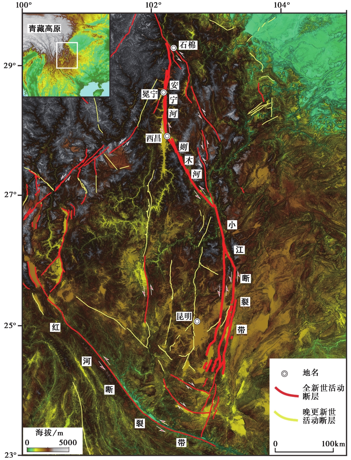
Fig. 1 Structural outline map of the Anninghe-Zemuhe-Xiaojiang(AZX) fault zone in the eastern boundary of the Sichuan-Yunnan block.
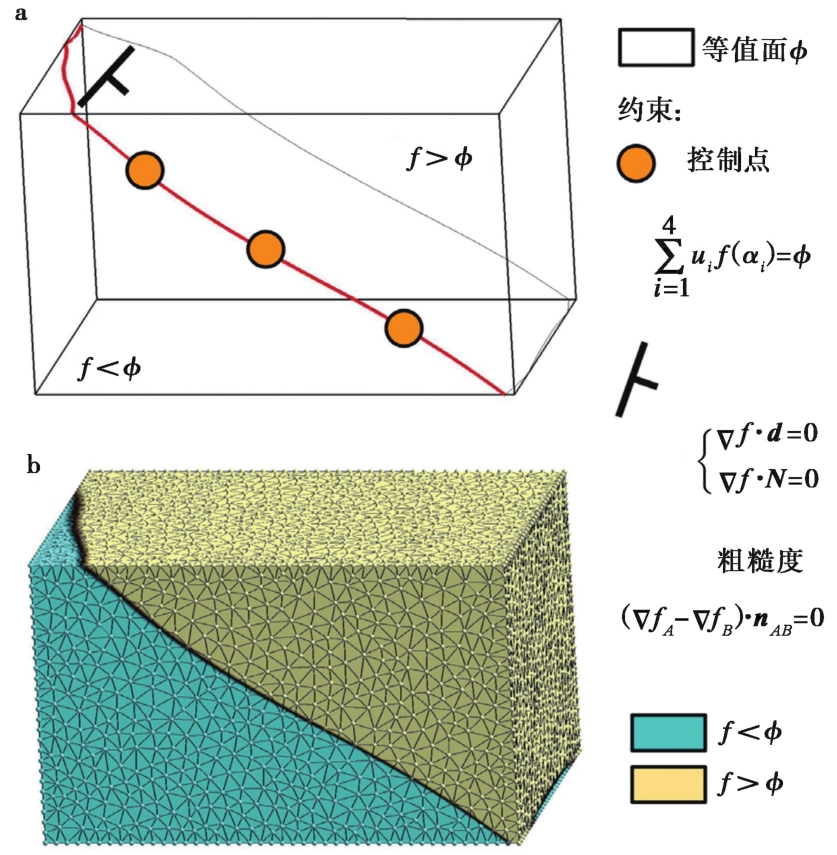
Fig. 2 Implicit modeling approach for 3D structural modeling of active fault(modified from Plesch et al., 2020).
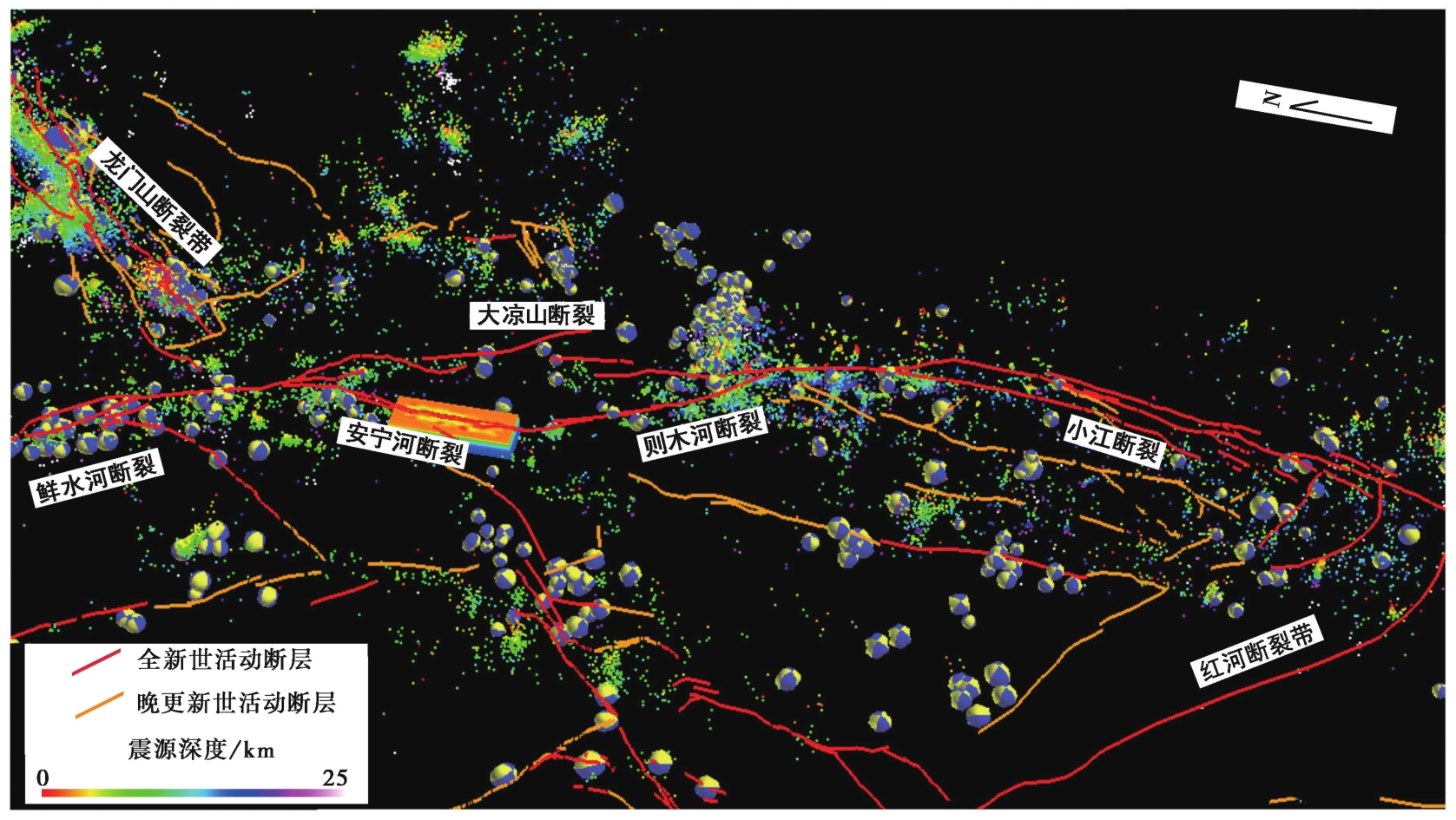
Fig. 3 Spatial distribution of data collected for constructing 3D models of active faults in this study illustrated by the SKUA-GoCAD modeling platform.
| 断层名称 | 数据类型 | 数据来源 | 权重分配 |
|---|---|---|---|
| 安宁河-则木河断层 | 断层迹线 | 中国地震断层信息系统① | 100 |
| 震源机制解 | 中国地震科学实验场② | 10 | |
| 中国震源机制解数据库③ | |||
| 精定位地震 | 中国地震科学实验场② | 0.01 | |
| 远离断层点 | 远离断层(off-fault)点自设 | 1 | |
| 小江断裂带中北段 | 断层迹线 | 中国地震断层信息系统① | 100 |
| 震源机制解 | 中国地震科学实验场② | 10 | |
| 中国震源机制解数据库③ | |||
| 精定位地震 | 中国地震科学实验场② | 0.01 | |
| Feng等( | |||
| 远离断层点 | 远离断层(off-fault)点自设 | 1 |
Table1 The type, source, and weight factor of multiple kinds of data used in modeling the Anninghe-Zemuhe-Xiaojiang fault zone in the eastern boundary of the Sichuan-Yunnan block
| 断层名称 | 数据类型 | 数据来源 | 权重分配 |
|---|---|---|---|
| 安宁河-则木河断层 | 断层迹线 | 中国地震断层信息系统① | 100 |
| 震源机制解 | 中国地震科学实验场② | 10 | |
| 中国震源机制解数据库③ | |||
| 精定位地震 | 中国地震科学实验场② | 0.01 | |
| 远离断层点 | 远离断层(off-fault)点自设 | 1 | |
| 小江断裂带中北段 | 断层迹线 | 中国地震断层信息系统① | 100 |
| 震源机制解 | 中国地震科学实验场② | 10 | |
| 中国震源机制解数据库③ | |||
| 精定位地震 | 中国地震科学实验场② | 0.01 | |
| Feng等( | |||
| 远离断层点 | 远离断层(off-fault)点自设 | 1 |
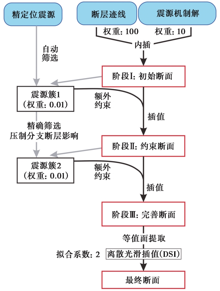
Fig. 4 The technique route map used in this study(adapted from Riesner et al., 2017).
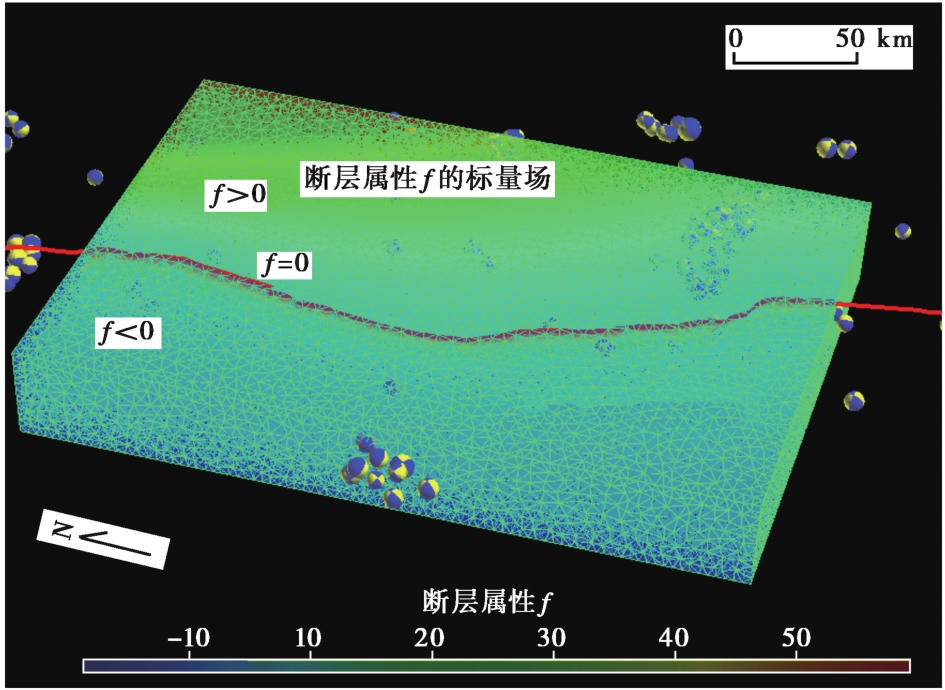
Fig. 5 Scalar field of tetrahedral mesh properties built for the Anninghe-Zemuhe fault zone.
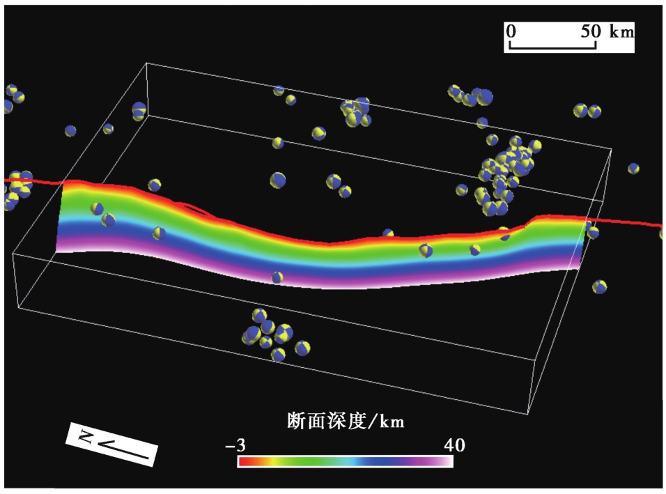
Fig. 6 Initial fault surface of Anninghe-Zemuhe fault zone extracted from the tetrahedral grids.
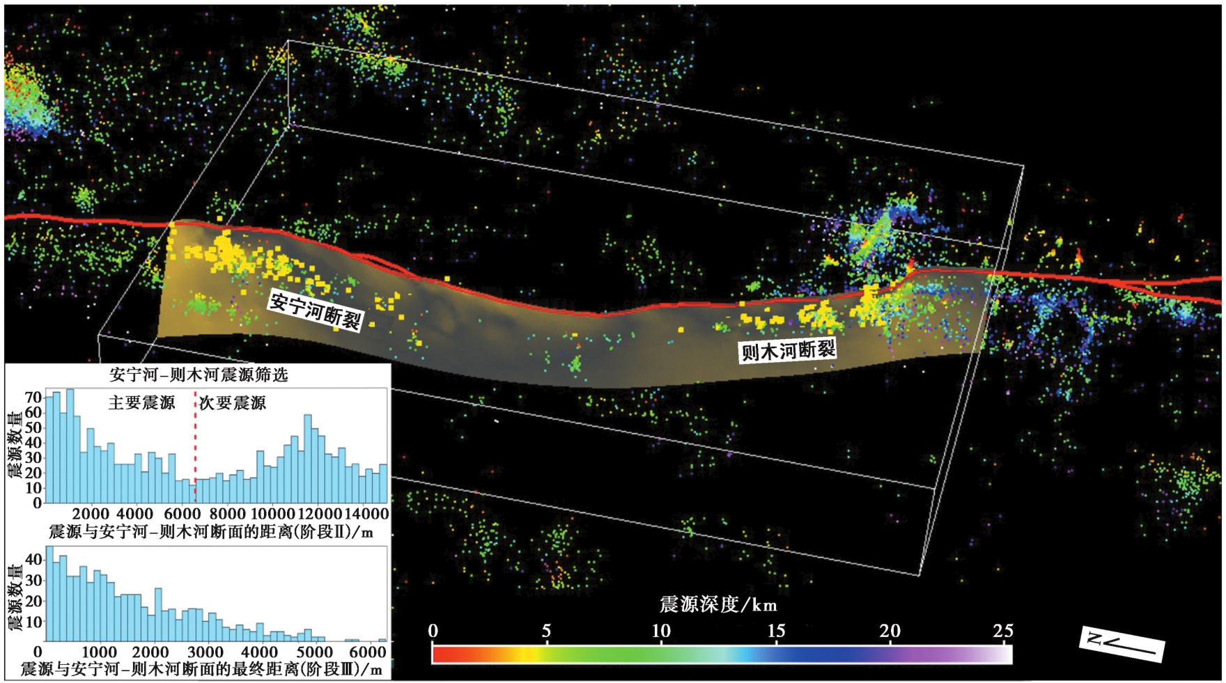
Fig. 7 The two-stage model suppression for the Anninghe-Zemuhe fault belt by calculating the hypocenter-fault distances to select closer seismic events.
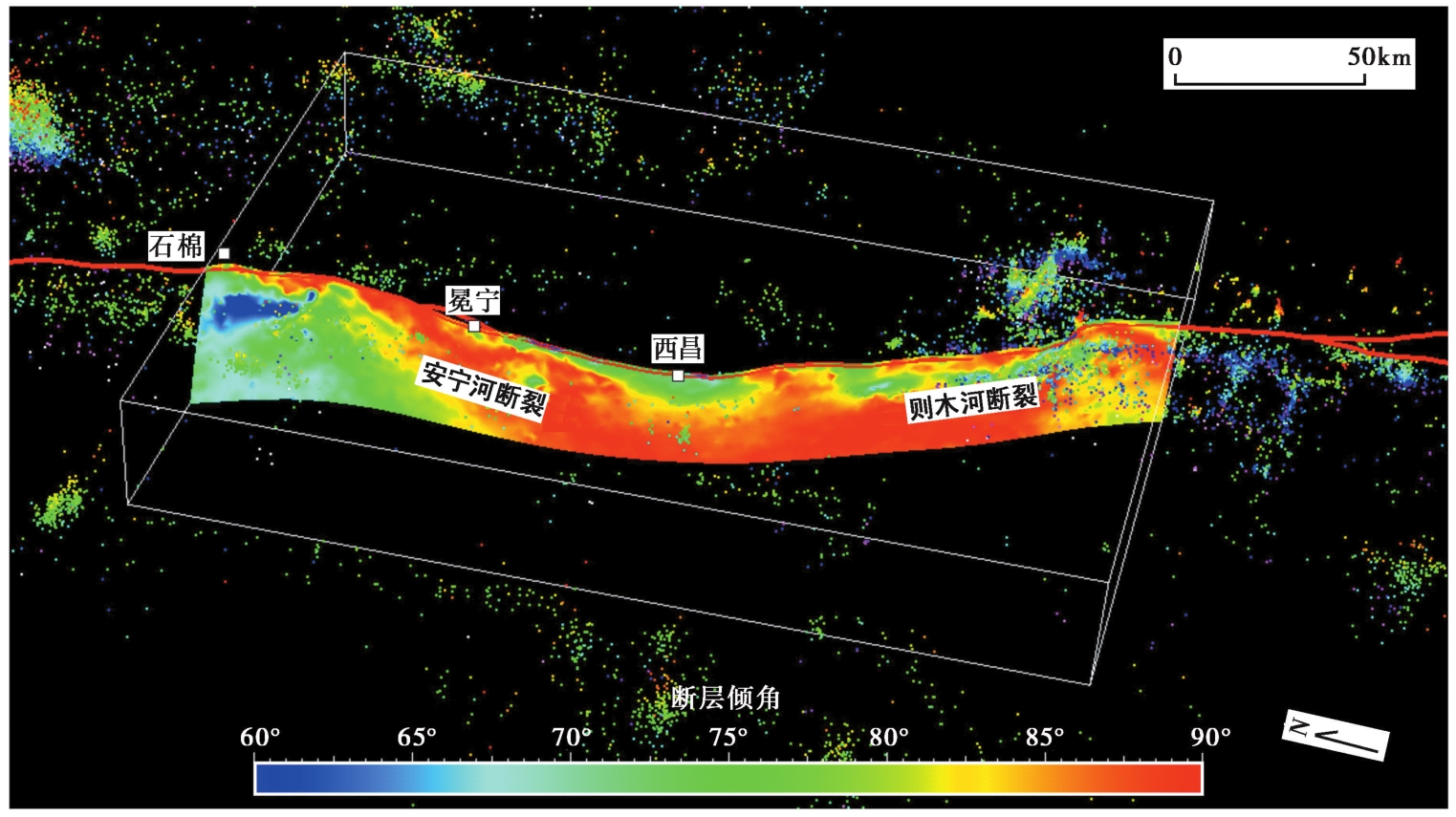
Fig. 8 Final three-dimensional structural model of the Anninghe-Zemuhe fault zone.
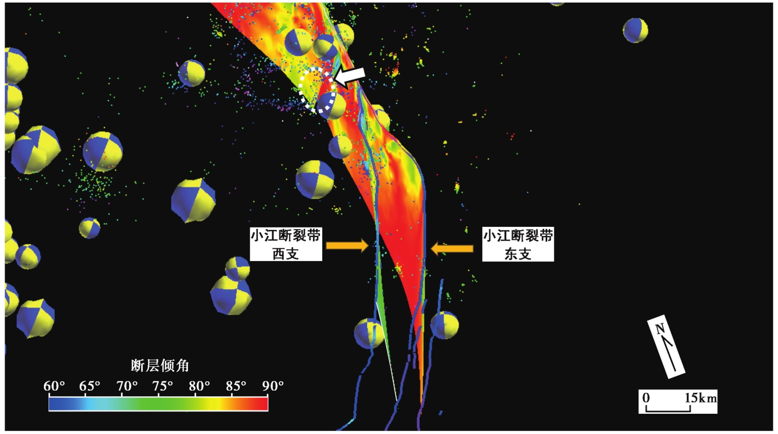
Fig. 9 Final three-dimensional structural model of north-central segments of the Xiaojiang fault zone.
| [1] |
常英娜, 梁春涛, 曹飞煌, 等. 2022. 基于波场梯度法研究安宁河-则木河断裂带速度结构[J]. 地球物理学报, 65(8): 2886—2903.
|
|
|
|
| [2] |
邓起东, 张培震, 冉勇康, 等. 2002. 中国活动构造基本特征[J]. 中国科学(D辑), 32(12): 1021—1030.
|
|
|
|
| [3] |
李玶. 1993. 鲜水河-小江断裂带[M]. 北京: 地震出版社:1—264.
|
|
|
|
| [4] |
任治坤, 田勤俭, 张军龙. 2007. 后差分GPS测量则木河断裂地震微地貌特征[J]. 地震, 27(3): 97—104.
|
|
|
|
| [5] |
冉勇康, 陈立春, 程建武, 等. 2008. 安宁河断裂冕宁以北晚第四纪地表变形与强震破裂行为[J]. 中国科学(D辑), 38(5): 543—554.
|
|
|
|
| [6] |
宋方敏, 汪一鹏, 俞维贤, 等. 1998. 小江活动断裂带: 中国活断层研究专辑[M]. 北京: 地震出版社:1—237.
|
|
|
|
| [7] |
闻学泽. 2000. 四川西部鲜水河-安宁河-则木河断裂带的地震破裂分段特征[J]. 地震地质, 22(3): 239—249.
|
|
|
|
| [8] |
徐锡伟, 闻学泽, 郑荣章, 等. 2003. 川滇地区活动块体最新构造变动样式及其动力来源[J]. 中国科学(D辑), 33(A1): 151—162.
|
|
|
|
| [9] |
张培震. 2008. 青藏高原东缘川西地区的现今构造变形、 应变分配与深部动力过程[J]. 中国科学(D辑), 38(9): 1041—1056.
|
|
|
|
| [10] |
中国地震局震害防御司. 1999. 中国近代地震目录: 公元1912—1990年, MS≥4.7[Z]. 北京: 中国科学技术出版社: 1—637.
|
|
Department of Earthquake Disaster Prevention, China Earthquake Administration. 1999. The Catalogue of Modern Earthquakes in China(AD 1912—AD 1990, MS≥4.7)[Z]. China Science and Technology Publishing House, Beijing: 1—637 (in Chinese).
|
|
| [11] |
DOI URL |
| [12] |
DOI URL |
| [13] |
|
| [14] |
DOI URL |
| [15] |
|
| [16] |
|
| [17] |
DOI URL |
| [18] |
|
| [19] |
DOI URL |
| [20] |
|
| [21] |
DOI URL |
| [22] |
|
| [23] |
DOI URL |
| [24] |
DOI URL |
| [25] |
DOI URL |
| [26] |
DOI URL |
| [27] |
|
| [28] |
|
| [29] |
|
| [30] |
DOI URL |
| [31] |
DOI URL |
| [32] |
DOI URL |
| [33] |
DOI URL |
| [34] |
DOI PMID |
| [35] |
|
| [36] |
DOI URL |
| [37] |
DOI URL |
| [38] |
DOI URL |
| [39] |
|
| [40] |
DOI URL |
| [41] |
DOI |
| [42] |
|
| [43] |
DOI URL |
| [44] |
|
| [45] |
|
| [1] | GUO Xiang-yun, FANG Li-hua, HAN Li-bo, LI Zhen-yue, LI Chun-lai, SU Shan. CHARACTERISTICS OF FOCAL MECHANISM AND STRESS FIELD IN THE EASTERN BOUNDARY OF THE SICHUAN-YUNNAN BLOCK [J]. SEISMOLOGY AND GEOLOGY, 2024, 46(2): 371-396. |
| [2] | XU Zhi-ping, ZHANG Yang, YANG Li-pu, XU Shun-qiang, JIANG Lei, TANG Lin, LIN Ji-yan. STUDY ON THE DEEP STRUCTURAL CHARACTERISTIC OF MAIN ACTIVE FAULTS IN HENAN PROVINCE AND ITS ADJACENT AREAS [J]. SEISMOLOGY AND GEOLOGY, 2022, 44(6): 1521-1538. |
| [3] | WU Gui-ju, YU Bing-fei, HAO Hong-tao, HU Min-zhang, TAN Hong-bo. THE DEEP STRUCTURAL CHARACTERISTICS AND THE SEIS-MOGENIC STRUCTURE OF THE YANGBI EARTHQUAKE REGION AND ITS SURROUNDING AREAS [J]. SEISMOLOGY AND EGOLOGY, 2021, 43(4): 739-756. |
| [4] | LI Jun, WANG Qin-cai, CUI Zi-jian, ZHANG Pei, ZHOU Lin, ZHOU Hui. CHARACTERISTICS OF FOCAL MECHANISMS AND STRESS FIELD IN THE EASTERN BOUNDARY OF SICHUAN-YUNNAN BLOCK AND ITS ADJACENT AREA [J]. SEISMOLOGY AND GEOLOGY, 2019, 41(6): 1395-1412. |
| [5] | DING Rui, REN Jun-jie, ZHANG Shi-min, LÜ Yan-wu, LIU Han-yong. LATE QUATERNARY PALEOEARTHQUAKES ON THE MIDDLE SEGMENT OF THE LIJIANG-XIAOJINHE FAULT, SOUTHEASTERN TIBET [J]. SEISMOLOGY AND GEOLOGY, 2018, 40(3): 622-640. |
| [6] | HAO Hai-jian, HE Hong-lin, WEI Zhan-yu, SHI Feng. GEOMETRIC CHARACTERISTICS OF CO-SEISMIC SURFACE RUPTURES AND ACTIVE FAULTS [J]. SEISMOLOGY AND GEOLOGY, 2017, 39(6): 1267-1282. |
| [7] | XU Jing, JI Ling-yun, JI Cun-wei, SUN He, ZHAO Qiang. COULOMB STRESS EVOLUTION AND SEISMIC HAZARD ALONG THE EASTERN BOUNDARY OF THE SICHUAN-YUNNAN BLOCK [J]. SEISMOLOGY AND GEOLOGY, 2017, 39(3): 451-469. |
| [8] | SUI Yuan, DU Ke-ping, YU Gui-hua, XU Xi-wei, WU Xi-yan, GAN De-qiang. design and construction of national active fault data integration and sharing platform [J]. SEISMOLOGY AND GEOLOGY, 2015, 37(4): 1115-1124. |
| [9] | ZHU Ai-yu, ZHANG Dong-ning, JIANG Chang-sheng, LI Ming. THE NUMERICAL SIMULATION OF THE STRAIN ENERGY DENSITY CHANGING RATE AND STRONG EARTHQUAKE RECURRENCE INTERVAL OF THE SICHUAN-YUNNAN BLOCK [J]. SEISMOLOGY AND GEOLOGY, 2015, 37(3): 906-927. |
| [10] | LI Zi-hong, LIU Hong-fu, ZHANG Min, ZENG Jin-yan. 3D VISUALIZATION AND MODELING OF SPATIAL RELATIONSHIP BETWEEN EARTHQUAKES AND ACTIVE FAULTS [J]. SEISMOLOGY AND GEOLOGY, 2013, 35(3): 565-575. |
| [11] | LI Feng, ZHANG Xiao-liang, LIU Hua-guo. SEISMIC HAZARD ANALYSIS OF THE MAIN FAULTS IN CHONGQING URBAN AREA [J]. SEISMOLOGY AND GEOLOGY, 2013, 35(3): 518-531. |
| [12] | SHEN Zhong-yan, ZHOU Jian-ping, GAO Jin-yao, WU Zhao-cai, YANG Chun-guo, TAO Chun-hui, YANG Yong, ZHANG Tao. QUATERNARY FAULTS OF THE QIANLIYAN UPLIFT IN THE NORTHERN SOUTH YELLOW SEA [J]. SEISMOLOGY AND GEOLOGY, 2013, 35(1): 64-74. |
| [13] | HUANG Xiong-nan, ZHANG Jia-sheng, LI Tian-bin, LIU Feng, FENG Jun. CHARACTERISTICS OF ACTIVE FAULTS BETWEEN THE NORTH SEGMENT OF THE NORTH-SOUTH SEISMIC BELT AND THE CENTRAL MONGOLIA [J]. SEISMOLOGY AND GEOLOGY, 2012, (4): 637-658. |
| [14] | HUANG Qing-Qiu, FU Ping, YOU Hui-Chuan, CHEN Wen-Ban, SONG Yi-Cheng, XIE You-Quan. FAULT ACTIVITIES OF LONGGAO PENINSULA IN FUQING COUNTY,FUJIAN PROVINCE [J]. SEISMOLOGY AND GEOLOGY, 2008, 30(2): 431-442. |
| [15] | LIN Chuan-yong, SHEN Jun, CHEN Xiao-de, SHI Lan-bin, HU Jun, XIANG Zhi-yong. APPLICATION OF MICROSCOPIC ANALYSIS TO THE PROSPECTING OF ACTIVE FAULTS IN URUMQI CITY, XINJIANG UYGUR AUTONOMOUS REGION, CHINA [J]. SEISMOLOGY AND GEOLOGY, 2008, 30(1): 218-235. |
| Viewed | ||||||
|
Full text |
|
|||||
|
Abstract |
|
|||||
