
SEISMOLOGY AND GEOLOGY ›› 2026, Vol. 48 ›› Issue (2): 520-539.DOI: 10.3969/j.issn.0253-4967.20240101
Previous Articles Next Articles
ASSESSING SEVERELY AFFECTED AREAS BY EARTHQUAKE USING MOBILE SIGNALLING DATA: A CASE STUDY OF THE 2023 MS6.2 JISHISHAN EARTHQUAKE, CHINA
GUO Xin-xin1)( ), WEI Ben-yong1,2),*(), SU Gui-wu1,2), QI Wen-hua1,2), ZHANG Teng-fei1)
- 1)
Institute of Geology ,China Earthquake Administration
2)Key Laboratory of Seismic and Volcanic Hazards ,China Earthquake Administration
-
Received:2025-08-05Revised:2025-10-10Online:2026-04-20Published:2026-05-14
基于手机信令数据判别地震影响重灾区——以2023年积石山MS6.2地震为例
郭欣欣1)(), 魏本勇1,2),*(), 苏桂武1,2), 齐文华1,2), 张腾飞1)
- 1)
中国地震局地质研究所
2)中国地震局地震与火山灾害重点实验室
-
通讯作者:* 魏本勇, 男, 1982年生, 博士, 研究员, 主要从事地震灾害风险评估、 灾害认知与响应、 灾后恢复和地方减灾研究, E-mail: bywei1982@ies.ac.cn。 -
作者简介:郭欣欣, 女, 1997年生, 现为中国地震局地质研究所第四纪地质学专业在读博士研究生, 研究方向为地震灾害风险分析, E-mail: 18536062880@163.com。 -
基金资助:国家自然科学基金(42177453); 中国地震局地质研究所基本科研业务专项(IGCEA1905); 西藏自治区科技计划项目(XZ202402ZD0001)
Cite this article
GUO Xin-xin, WEI Ben-yong, SU Gui-wu, QI Wen-hua, ZHANG Teng-fei. ASSESSING SEVERELY AFFECTED AREAS BY EARTHQUAKE USING MOBILE SIGNALLING DATA: A CASE STUDY OF THE 2023 MS6.2 JISHISHAN EARTHQUAKE, CHINA[J]. SEISMOLOGY AND GEOLOGY, 2026, 48(2): 520-539.
郭欣欣, 魏本勇, 苏桂武, 齐文华, 张腾飞. 基于手机信令数据判别地震影响重灾区——以2023年积石山MS6.2地震为例[J]. 地震地质, 2026, 48(2): 520-539.
share this article
Add to citation manager EndNote|Ris|BibTeX
URL: https://www.dzdz.ac.cn/EN/10.3969/j.issn.0253-4967.20240101
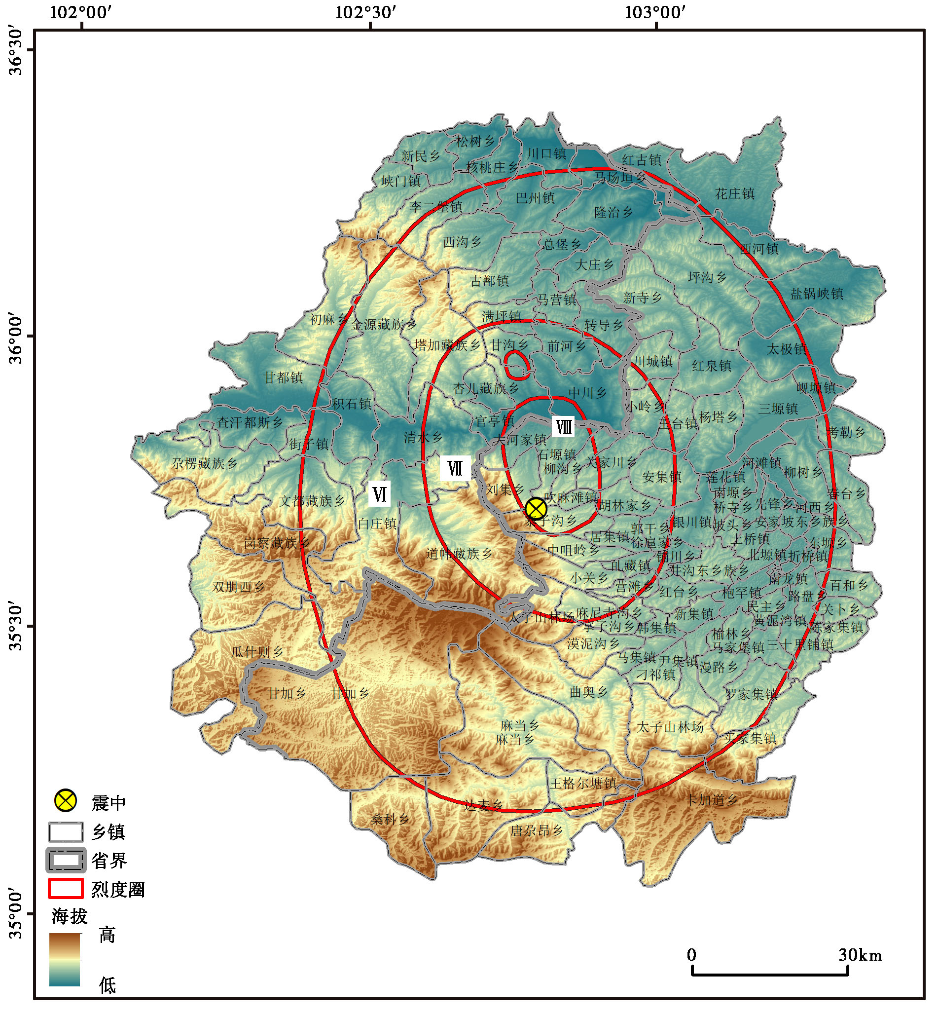
Fig. 1 The location of the study area.

Fig. 2 Distribution of GeoHash grid sample point.
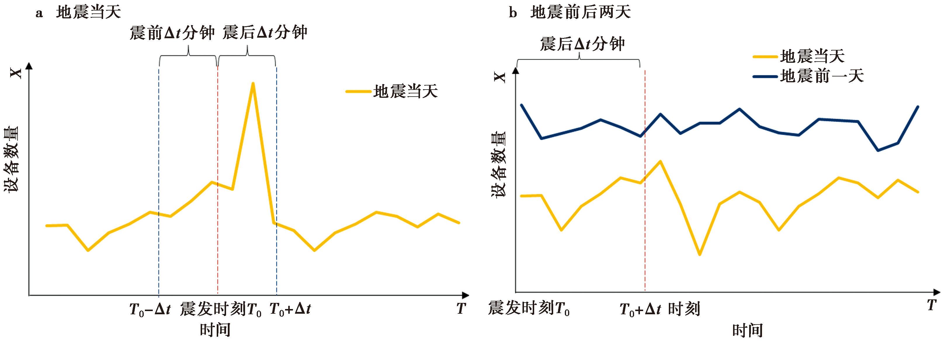
Fig. 3 Schematic diagram of the research data timeline.
| 时间范围 | 烈度Ⅷ (331km2) | 烈度Ⅶ (1514km2) | 烈度Ⅵ (6519km2) | 总研究区 (8364km2) |
|---|---|---|---|---|
| C13 | 20 | 6 | 66 | 92 |
| C15 | 26 | 15 | 83 | 124 |
| C110 | 38 | 27 | 122 | 187 |
| C23 | 22 | 15 | 65 | 102 |
| C25 | 25 | 23 | 83 | 131 |
| C210 | 38 | 38 | 111 | 187 |
Table 2 Significant numbers of GeoHash grid sample points in different intensity areas
| 时间范围 | 烈度Ⅷ (331km2) | 烈度Ⅶ (1514km2) | 烈度Ⅵ (6519km2) | 总研究区 (8364km2) |
|---|---|---|---|---|
| C13 | 20 | 6 | 66 | 92 |
| C15 | 26 | 15 | 83 | 124 |
| C110 | 38 | 27 | 122 | 187 |
| C23 | 22 | 15 | 65 | 102 |
| C25 | 25 | 23 | 83 | 131 |
| C210 | 38 | 38 | 111 | 187 |
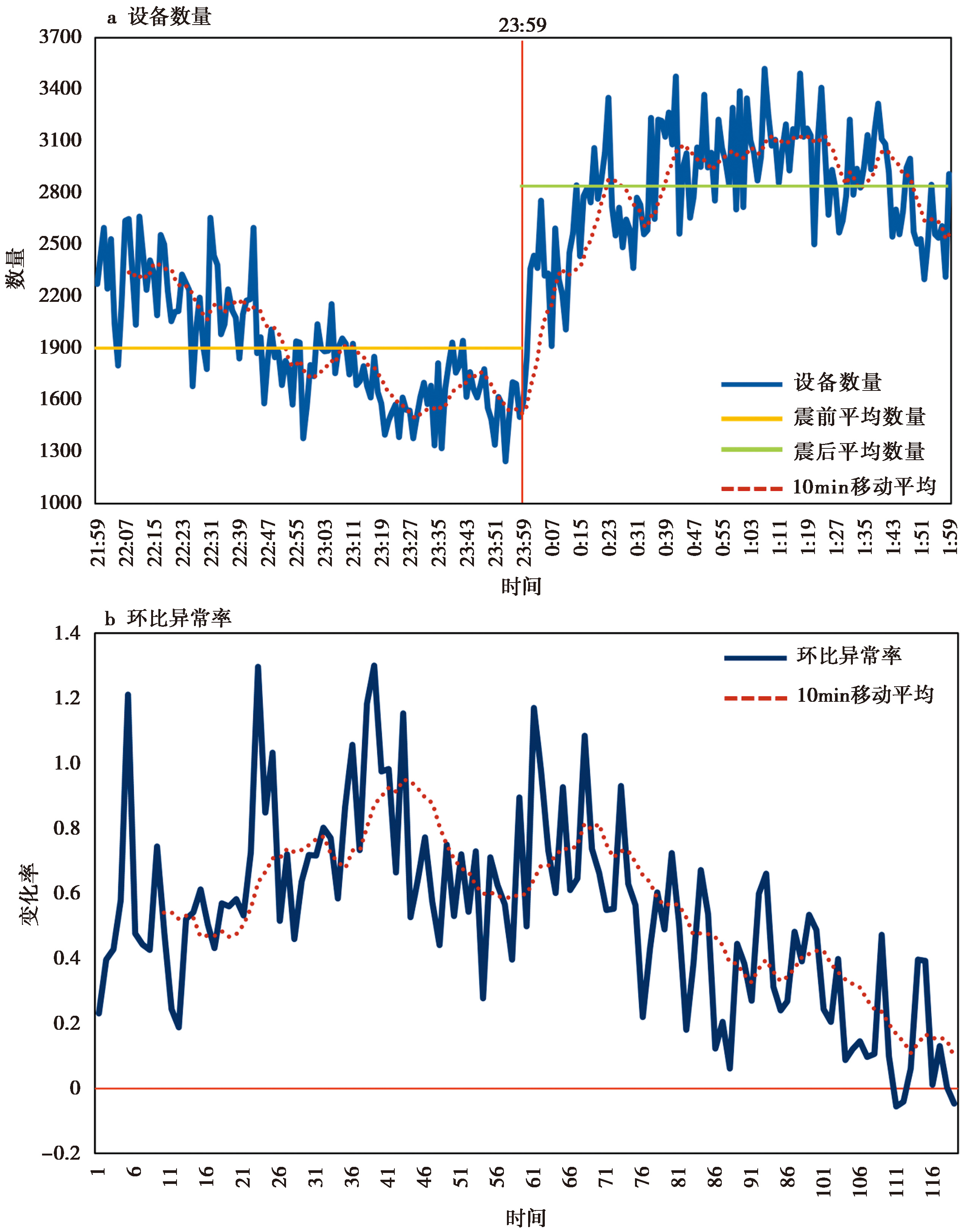
Fig. 4 Day-on-day time variation.
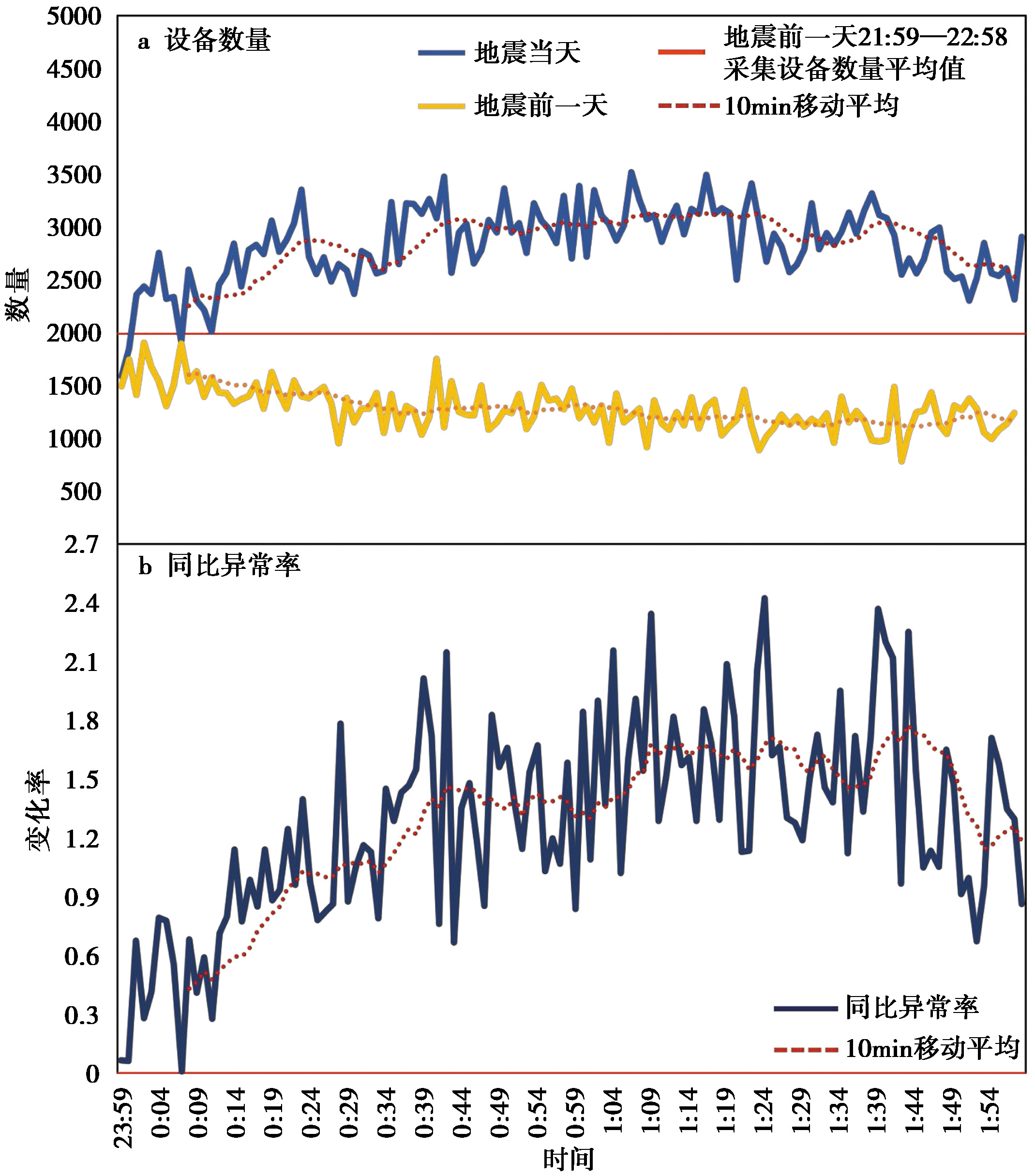
Fig. 5 Year-on-year time variation.
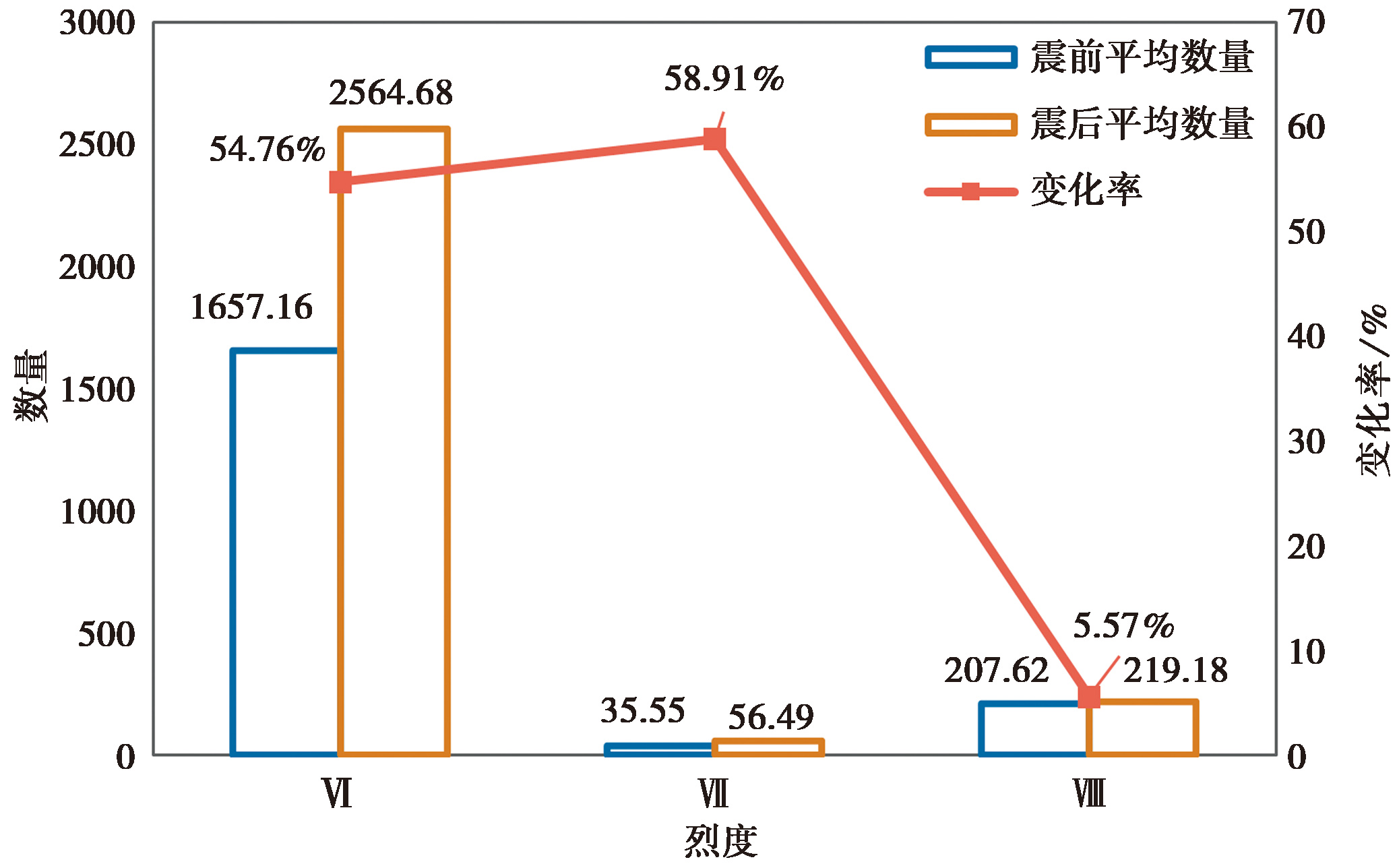
Fig. 6 Comparison of the average number of mobile signalling.
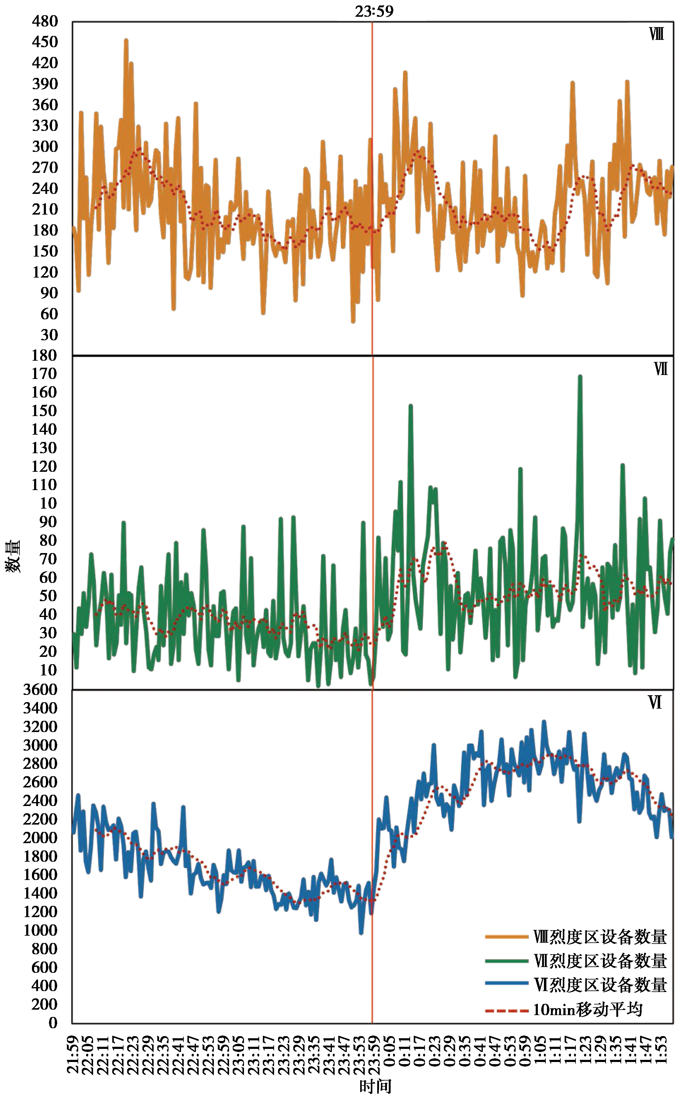
Fig. 7 Day-on-day time variation in different intensity areas.
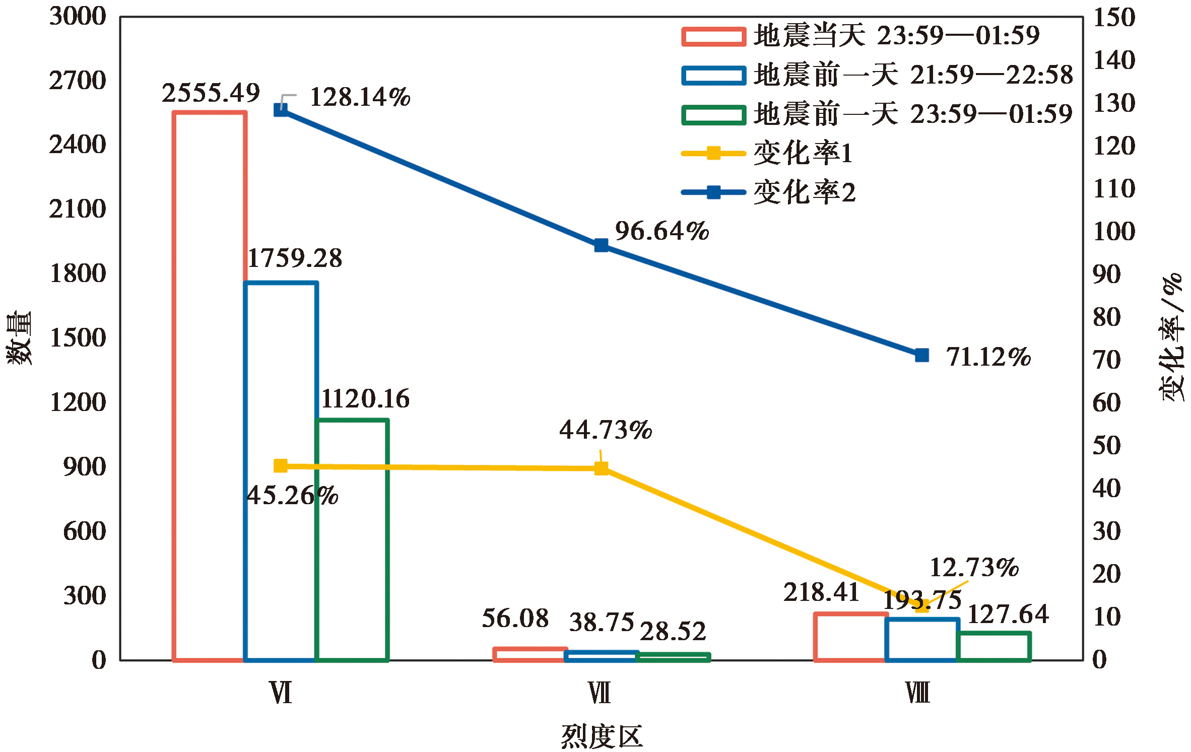
Fig. 8 Comparison of the average number of mobile signalling before and after two days of the earthquake.
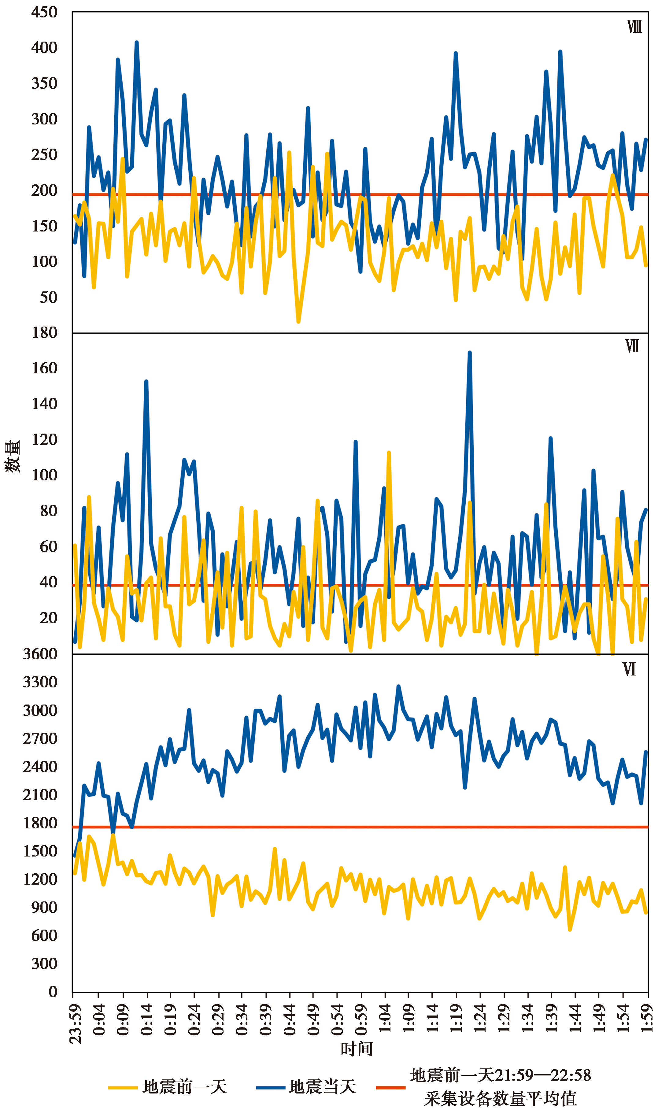
Fig. 9 Year-on-year time variation in different intensity areas.
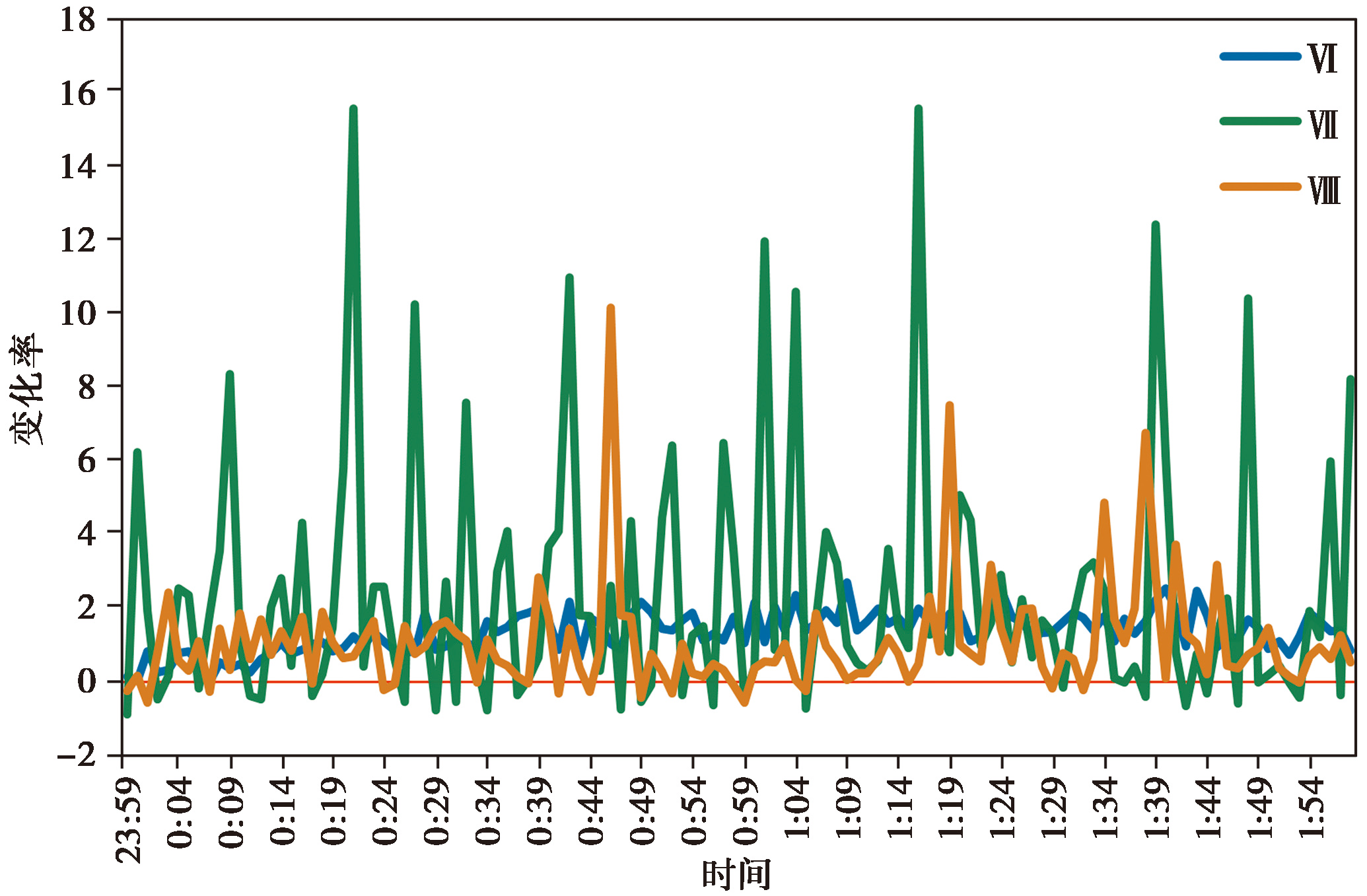
Fig. 10 Year-on-year abnormality rate time variation in different intensity areas.
| 变量 | Idt | Ddt |
|---|---|---|
| C13 | -0.215* | 0.214* |
| C15 | -0.113 | 0.126 |
| C110 | -0.166* | 0.223** |
| C23 | -0.390** | 0.457** |
| C25 | -0.339** | 0.353** |
| C210 | -0.293** | 0.269** |
Table 3 Correlations between the intensity of mobile signalling and other variables
| 变量 | Idt | Ddt |
|---|---|---|
| C13 | -0.215* | 0.214* |
| C15 | -0.113 | 0.126 |
| C110 | -0.166* | 0.223** |
| C23 | -0.390** | 0.457** |
| C25 | -0.339** | 0.353** |
| C210 | -0.293** | 0.269** |

Fig. 11 Interpolation results of year-on-year anomaly rate.
| [1] |
樊嵘, 孟大志, 徐大舜. 2014. 统计相关性分析方法研究进展[J]. 数学建模及其应用, 3(1): 1—12.
|
|
|
|
| [2] |
高孟潭. 2024. 从积石山6.2级地震看西部农村地震安全[J]. 防灾博览, (1): 4—9.
|
|
|
|
| [3] |
金星, 张红才, 李军, 等. 2013. 地震仪器烈度标准初步研究[J]. 地球物理学进展, 28(5): 2336—2351.
|
|
|
|
| [4] |
李东平, 黄乐, 陈海鹏, 等. 2017. 基于手机位置数据的四川九寨沟7.0级地震人流分析[J]. 中国地震, 33(4): 602—612.
|
|
|
|
| [5] |
李志强, 李亦纲, 林均岐. 2017. 四川九寨沟7.0级地震灾害特点分析[J]. 中国应急救援, 65(5): 4—7.
|
|
|
|
| [6] | |
|
|
|
| [7] |
庞晓克, 聂高众, 张昕, 等. 2019. 基于手机位置数据的地震灾情指标选择[J]. 中国地震, 35(1): 144—157.
|
|
|
|
| [8] |
帅向华, 冯蔚, 董翔, 等. 2020. 震后分时段地震烈度影响场快速判识方法研究[J]. 武汉大学学报(信息科学版), 45(8): 1195—1204.
|
|
|
|
| [9] |
汪素云, 俞言祥, 高阿甲, 等. 2000. 中国分区地震动衰减关系的确定[J]. 中国地震, 16(2): 99—106.
|
|
|
|
| [10] |
王运生, 赵波, 吉锋, 等. 2024. 2023年甘肃积石山 MS6.2 地震震害异常的启示[J]. 成都理工大学学报(自然科学版), 51(1): 1—8.
|
|
|
|
| [11] |
魏本勇, 聂高众, 苏桂武, 等. 2017. 地震灾害埋压人员评估的研究进展[J]. 灾害学, 32(1): 155—159.
|
|
|
|
| [12] |
|
| [13] |
|
| [14] |
|
| [15] |
|
| [16] |
|
| [17] |
|
| [18] |
|
| [19] |
|
| [20] |
|
| [21] |
|
| [22] |
|
| [23] |
|
| [24] |
|
| [1] | YANG Ying-hui, XIE Li-yuan, XU Qiang, WANG Yun-sheng, ZHAO Jing-jing, WANG Dao-ming, CHEN Qiang. RESEARCH OF THE INSAR COSEISMIC DEFORMATION AND INTERSEISMIC FAULTING MECHANISM OF THE 2023 JISHISHAN MW6.1 EARTHQUAKE [J]. SEISMOLOGY AND GEOLOGY, 2025, 47(5): 1416-1437. |
| [2] | REN Jia, WANG Xiu-ying, ZHAO Guo-cun, FAN Xi-wei, GAO Peng, ZHANG Shan-shan, MA Zhi-xia. COMPARISON OF DIFFERENCES IN GROUND MOTION DATA OBTAINED BY DIFFERENT SITE CONDITIONS OF THE JISHISHAN M6.2 EARTHQUAKE [J]. SEISMOLOGY AND GEOLOGY, 2025, 47(4): 1075-1089. |
| [3] | YUAN Xiao-xiang, LIN Xu-chuan, CHEN Zi-feng, ZHANG Jian-long, DOU Ai-xia, XIAO Ben-fu, DU Hao-guo, YU Si-han, DING Xiang, FANG Jie, WANG Shu-min. COMPARATIVE STUDY ON BUILDING DAMAGE CAUSED BY THE 2025 MS6.8 EARTHQUAKE IN DINGRI, XIZANG, BASED ON REMOTE SENSING AND SEISMIC SIMULATION [J]. SEISMOLOGY AND GEOLOGY, 2025, 47(3): 932-948. |
| [4] | AN Ji-wen, XU Jing-hai, NIE Gao-zhong, BAI Xian-fu. earthquake disaster rapid assessment for emergency response supported by high-precision data of hazard bearing body [J]. SEISMOLOGY AND GEOLOGY, 2015, 37(4): 1225-1241. |
| Viewed | ||||||
|
Full text |
|
|||||
|
Abstract |
|
|||||
Copyright © SEISMOLOGY AND GEOLOGY, All Rights Reserved.
Tel: 010-62009049/9063 E-mail: dzdz@ies.ac.cn
Powered by Beijing Magtech Co., Ltd.