
SEISMOLOGY AND GEOLOGY ›› 2026, Vol. 48 ›› Issue (2): 403-422.DOI: 10.3969/j.issn.0253-4967.20240113
Previous Articles Next Articles
REVEALING THE SHALLOW SEDIMENTARY STRUCTURE OF THE WESTERN WEIHE BASIN USING THE HVSR METHOD WITH A SHORT-PERIOD DENSE ARRAY
RUAN Ming-ming1)( ), TIAN Xiao-feng1), ZHENG Cheng-long1), SONG Xiang-hui1), WANG Liang1), HE Chang-xun2), WANG Shuai-jun1),*()
- 1)
Geophysical Exploration Center of China Earthquake Administration
2)Mineral Resources Exploration Center of Henan Geological Bureau
-
Received:2025-02-17Revised:2025-04-10Online:2026-04-20Published:2026-05-14
利用短周期密集台阵HVSR法揭示渭河盆地西缘浅层沉积层结构
阮明明1)(), 田晓峰1), 郑成龙1), 宋向辉1), 王亮1), 何长勋2), 王帅军1),*()
- 1)
中国地震局地球物理勘探中心
2)河南省地质局矿产资源勘查中心
-
通讯作者:* 王帅军, 男, 1978年生, 研究员, 主要从事地震测深资料处理与解释研究, E-mail: wsjdzj@126.com。 -
作者简介:阮明明, 男, 1990年生, 2019年于中国地震局地球物理研究所获固体地球物理学专业硕士学位, 工程师, 主要从事地震构造探察和背景噪声研究, E-mail: ruanmingming90@163.com。 -
基金资助:中国地震局地球物理勘探中心青年基金项目(YFGEC2022002); 国家重点研发计划项目(2018YFC150320); 中国地震局地质研究所国家野外科学观测研究站研究课题(NORSTY2022-05)
Cite this article
RUAN Ming-ming, TIAN Xiao-feng, ZHENG Cheng-long, SONG Xiang-hui, WANG Liang, HE Chang-xun, WANG Shuai-jun. REVEALING THE SHALLOW SEDIMENTARY STRUCTURE OF THE WESTERN WEIHE BASIN USING THE HVSR METHOD WITH A SHORT-PERIOD DENSE ARRAY[J]. SEISMOLOGY AND GEOLOGY, 2026, 48(2): 403-422.
阮明明, 田晓峰, 郑成龙, 宋向辉, 王亮, 何长勋, 王帅军. 利用短周期密集台阵HVSR法揭示渭河盆地西缘浅层沉积层结构[J]. 地震地质, 2026, 48(2): 403-422.
share this article
Add to citation manager EndNote|Ris|BibTeX
URL: https://www.dzdz.ac.cn/EN/10.3969/j.issn.0253-4967.20240113

Fig. 1 General geological map of Weihe Basin(a), and location of dense seismic stations(b).
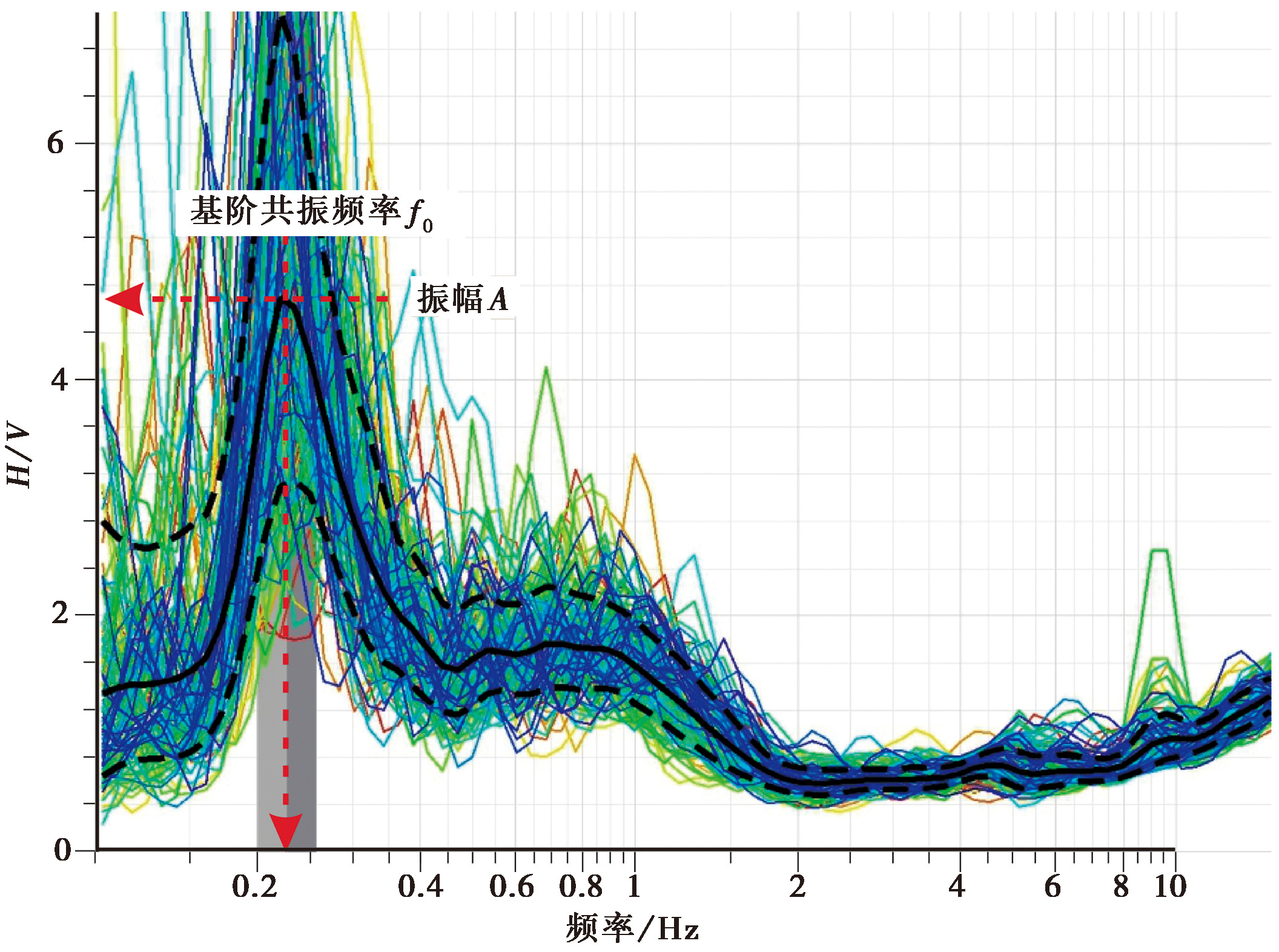
Fig. 2 The HVSR curve of a single station.
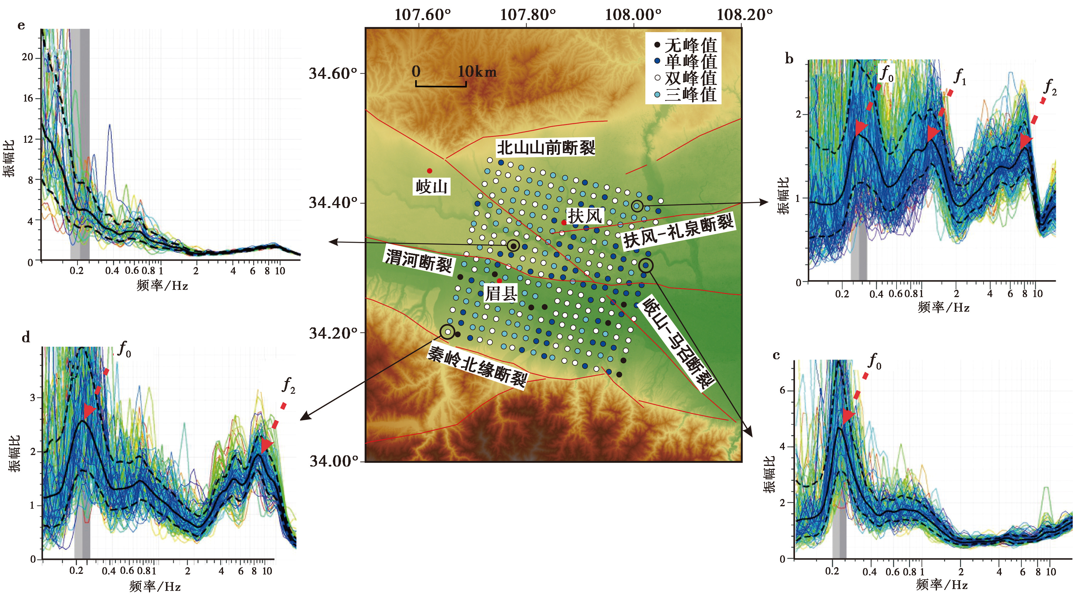
Fig. 3 Four typical HVSR curves in this study.
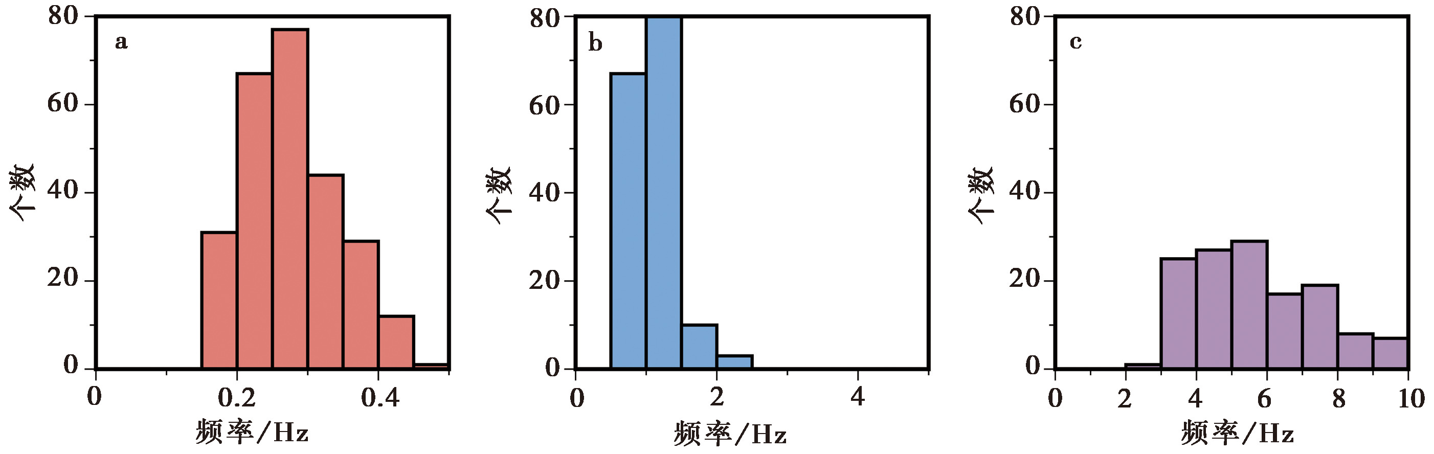
Fig. 4 Histogram of peak frequency distribution.
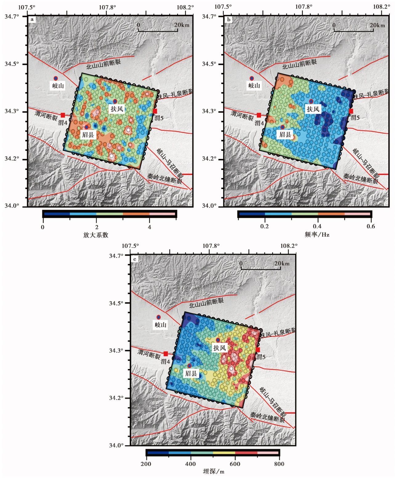
Fig. 5 Maps showing amplitude(a), frequency(b), and sedimentary layer thickness(c) for peak f0.

Fig. 6 Maps showing amplitude(a), frequency(b), and sedimentary layer thickness(c) for peak f1.
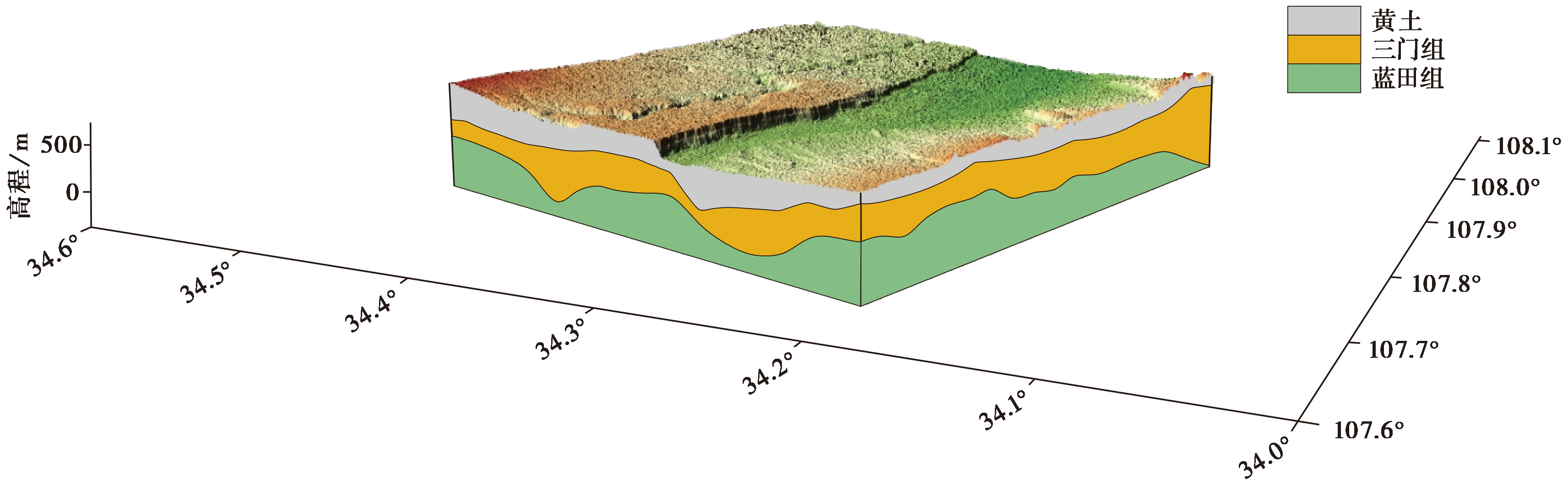
Fig. 7 Three dimensional sedimentary layer model near the surface in the study area.
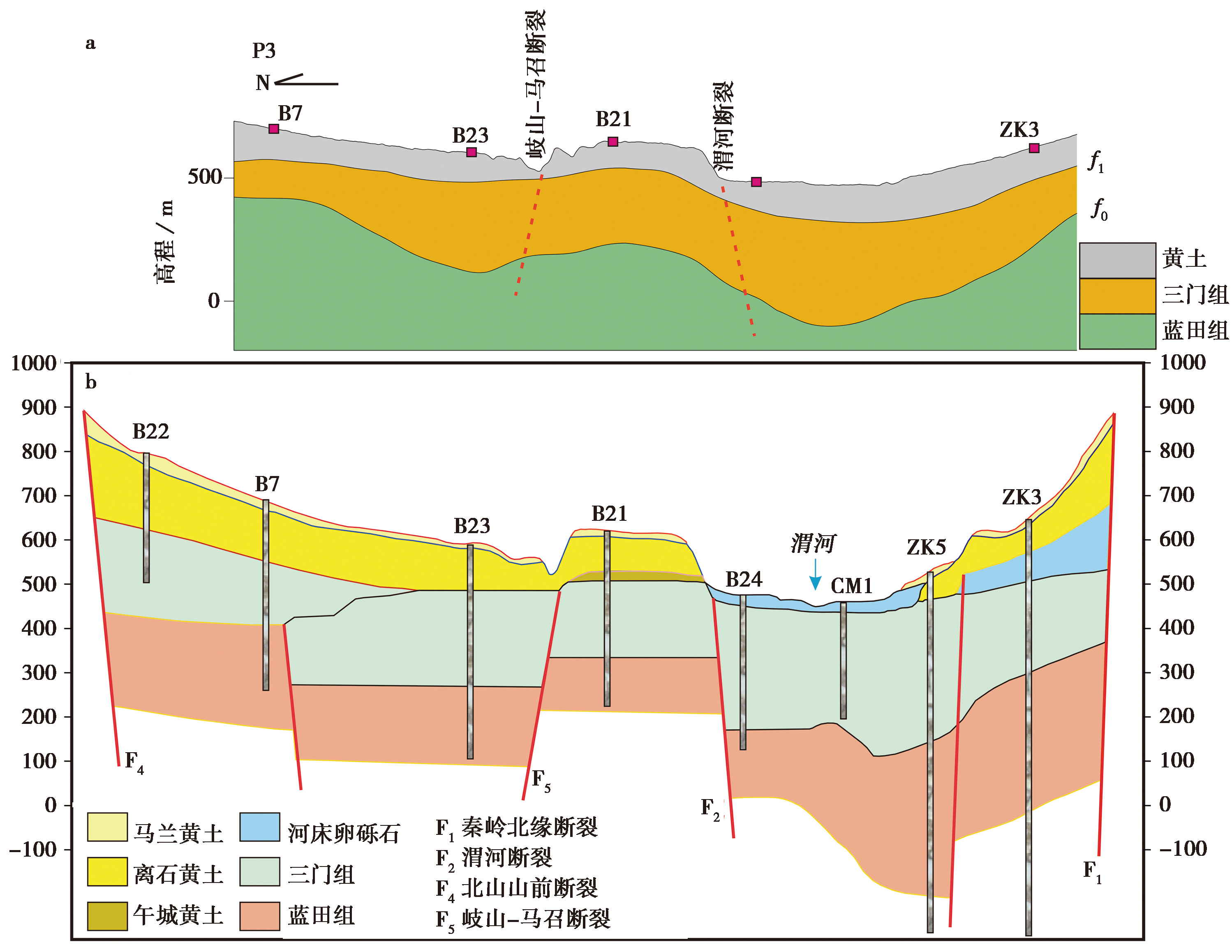
Fig. 8 Sediment thickness along profile P3 derived from the HVSR method(a) and cross-section of borehole P3(b).
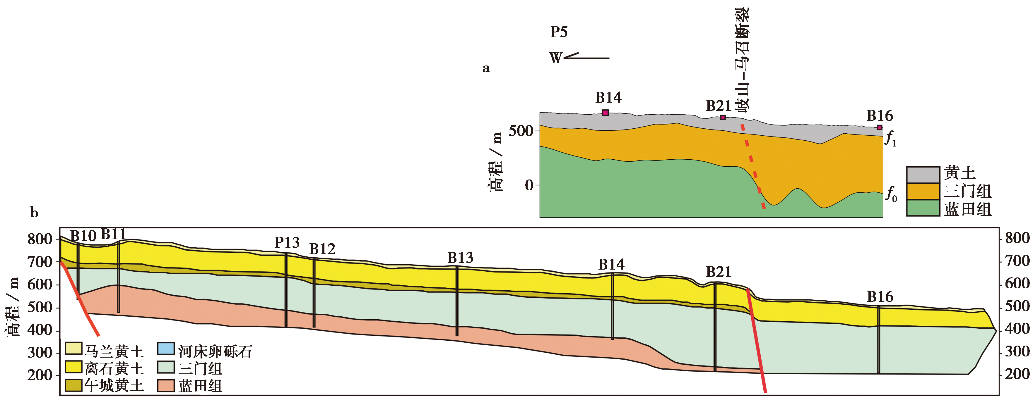
Fig. 9 Sediment thickness along profile P5 derived from the HVSR method(a) and cross-section of borehole P5(b).
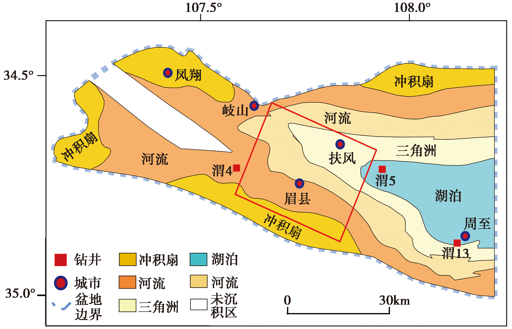
Fig. 10 Lithofacies paleogeographic map of western Weihe Basin in Sanmen Age(modified after LI Zhi-chao, 2017).
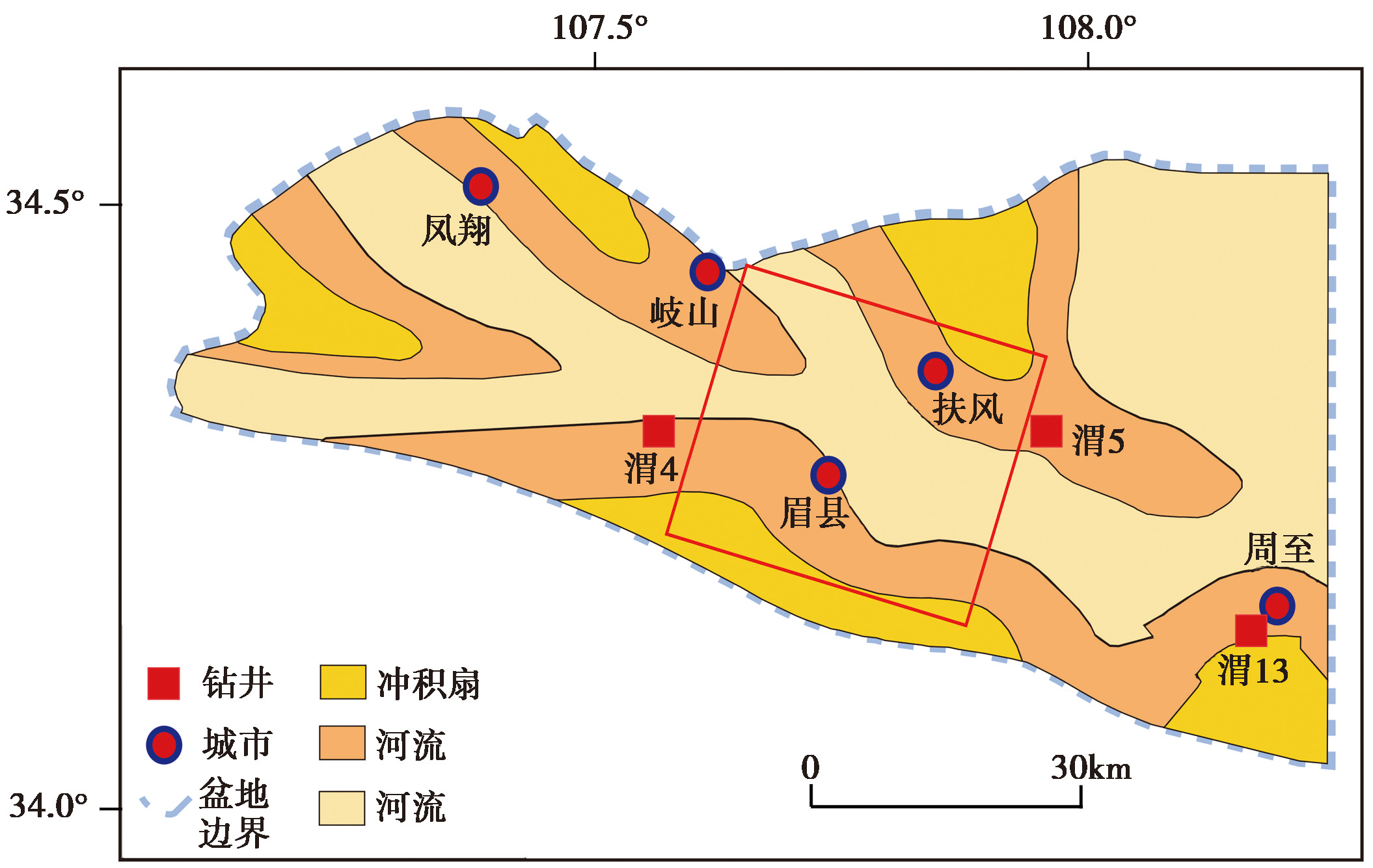
Fig. 11 Lithofacies paleogeographic map of western Weihe Basin in Qinchuan Age (modified after LI Zhi-chao, 2017).
| [1] |
陈棋福, 刘澜波, 王伟君, 等. 2008. 利用地脉动探测北京城区的地震动场地响应[J]. 科学通报, 53(18): 2229—2235.
|
|
|
|
| [2] |
冯策, 宋秀青, 王仁涛, 等. 2024. 基于背景噪声层析成像反演上海及邻区S波速度结构[J]. 地震地质, 46(6): 1374—1390. doi: 10.3969/j.issn.0253-4967.2024.06.009.
|
|
|
|
| [3] |
国家地震局“鄂尔多斯周缘活动断裂系”课题组. 1988. 鄂尔多斯周缘活动断裂系[M]. 北京: 地震出版社.
|
|
The Research Group on “Active Fault System around Ordos Massif” State Seismological Bureau. 1988. Active Fault System around Ordos Massif[M]. Seismological Press, Beijing (in Chinese).
|
|
| [4] |
郭明珠, 谢礼立, 高尔根, 等. 1999. 利用地脉动进行场地反应分析研究综述[J]. 世界地震工程, 15(3): 14—19.
|
|
|
|
| [5] |
李成, 姚华建, 邓宝, 等. 2023. 基于背景噪声方法的花岗岩型稀土矿地壳浅部结构特征及构造意义: 以江西赣州安西矿区为例[J]. 地球物理学报, 66(10): 4132—4148.
|
|
|
|
| [6] |
李智超. 2017. 渭河盆地新生代岩相古地理及环境演化[D]. 西安: 西北大学.
|
|
|
|
| [7] |
李智超, 李文厚, 李永项, 等. 2016. 陕西渭河地区新生代地层及沉积环境演化[J]. 地层学杂志, 40(2): 168—178.
|
|
|
|
| [8] |
刘国明. 2015. 利用背景噪声研究地震波速度变化及其在长白山火山监测中的应用[J]. 地震地质, 37(2): 576—587. doi: 10.3969/j.issn.0253-4967.2015.02.019.
|
|
|
|
| [9] |
刘护军, 薛祥煦. 2004. 对渭河盆地新生界及其年代的讨论[J]. 地球科学与环境学报, 26(4): 1—5.
|
|
|
|
| [10] |
刘护军. 2004. 渭河盆地的形成演化与东秦岭的隆升[D]. 西安: 西北大学.
|
|
|
|
| [11] |
彭菲, 王伟君, 寇华东. 2020. 三河—平谷地区地脉动H/V谱比法探测: 场地响应、 浅层沉积结构及其反映的断层活动[J]. 地球物理学报, 63(10): 3775—3790.
|
|
|
|
| [12] |
秦彤威, 王少曈, 冯宣政, 等. 2021. 微动H/V谱比方法[J]. 地球与行星物理论评, 52(6): 587—622.
|
|
|
|
| [13] |
荣棉水, 王继鑫, 李小军, 等. 2023. 场地土层速度结构的背景噪声反演方法及其应用[J]. 地球物理学报, 66(2): 530—545.
|
|
|
|
| [14] |
邵广周, 李远林, 岳亮. 2022. 主动源与被动源面波联合勘探在黄土覆盖区三维成像中的应用[J]. 物探与化探, 46(4): 897—903.
|
|
|
|
| [15] |
王斌. 2014. 渭河盆地新生代沉积演化: 盆山耦合与风尘沉积[D]. 南京: 南京大学.
|
|
|
|
| [16] |
王斌, 郑洪波, 王平, 等. 2013. 渭河盆地新生代地层与沉积演化研究: 现状和问题[J]. 地球科学进展, 28(10): 1126—1135.
|
|
|
|
| [17] |
王冲. 2023. 基于物探资料的典型盆地效应研究[D]. 哈尔滨: 中国地震局工程力学研究所.
|
|
|
|
| [18] |
王海云. 2011. 渭河盆地中土层场地对地震动的放大作用[J]. 地球物理学报, 54(1): 137—150.
|
|
|
|
| [19] |
王继鑫, 荣棉水, 符力耘, 等. 2020. 用微动台阵记录联合反演场地浅层速度结构—以唐山响嘡台3#场地为例[J]. 地震地质, 42(6): 1335—1353. doi: 10.3969/j.issn.0253-4967.2020.06.005.
|
|
|
|
| [20] |
王苏民, 吴锡浩, 张振克, 等. 2001. 三门古湖沉积记录的环境变迁与黄河贯通东流研究[J]. 中国科学(D辑), 31(9): 760—768.
|
|
|
|
| [21] |
王伟君, 陈棋福, 齐诚, 等. 2011. 利用噪声 HVSR方法探测近地表结构的可能性和局限性: 以保定地区为例[J]. 地球物理学报, 54(7): 1783—1797.
|
|
|
|
| [22] |
熊成, 叶秀薇, 张严心, 等. 2023. 噪声HVSR法在OBS探测中的应用: 以珠江口外海OBS台阵为例[J]. 地球物理学报, 66(7): 2951—2960.
|
|
|
|
| [23] |
徐勇. 2023. 密集线性台阵背景噪声成像在渭河盆地精细结构刻画中的应用[D]. 合肥: 中国科学技术大学.
|
|
|
|
| [24] |
杨晨艺, 李晓妮, 冯希杰, 等. 2021. 渭河盆地北缘口镇-关山断层的晚第四纪—现今的活动性[J]. 地震地质, 43(3): 504—520. doi: 10.3969/j.issn.0253-4967.2021.03.003.
|
|
|
|
| [25] |
张若晗, 徐佩芬, 凌甦群, 等. 2020. 基于微动H/V谱比法的土石分界面探测研究: 以济南中心城区为例[J]. 地球物理学报, 63(1): 339—350.
|
|
|
|
| [26] |
张天宇. 2020. 鄂尔多斯西南缘晚新生代盆地地质-地貌演化[D]. 西安: 长安大学.
|
|
|
|
| [27] |
张岳桥, 施炜, 董树文. 2019. 华北新构造: 印欧碰撞远场效应与太平洋俯冲地幔上涌之间的相互作用[J]. 地质学报, 93(5): 971—1001.
|
|
|
|
| [28] |
朱晓刚. 2020. 渭河盆地宝鸡凹陷构造特征研究[D]. 西安: 西安石油大学.
|
|
|
|
| [29] |
宗健业, 孙新蕾, 张鹏. 2020. 利用 HVSR方法研究广州地区的场地效应及估算地震灾害特征[J]. 地震地质, 42(3): 628—639. doi: 10.3969/j.issn.0253-4967.2020.03.006.
|
|
|
|
| [30] |
DOI URL |
| [31] |
|
| [32] |
|
| [33] |
|
| [34] |
|
| [35] |
|
| [36] |
DOI |
| [37] |
|
| [38] |
|
| [39] |
|
| [40] |
DOI URL |
| [41] |
|
| [42] |
|
| [43] |
|
| [44] |
|
| [45] |
|
| [46] |
|
| [47] |
|
| [48] |
|
| [1] | RUAN Ming-ming, LIU Qiao-xia, DUAN Yong-hong, WANG Shuai-jun, ZHENG Cheng-long, WANG Liang. USING SEISMIC AMBIENT NOISE HORIZONTAL-TO-VERTICAL SPECTRAL RATIO(HVSR) METHOD TO DETECT SITE RESPONSE AND SHALLOW SEDIMENTARY STRUCTURE IN XIONG’AN AREA [J]. SEISMOLOGY AND GEOLOGY, 2024, 46(5): 1106-1122. |
| [2] | ZHOU Ming, DUAN Yong-hong, TAN Yu-juan, QIU Yong. THE 3-D SHALLOW VELOCITY STRUCTURE OF THE MIDDLE-NORTH SECTION OF THE DONGPU DEPRESSION DERIVED FROM DENSE ARRAY OBSERVATIONS OF AMBIENT NOISE [J]. SEISMOLOGY AND GEOLOGY, 2023, 45(2): 517-535. |
| [3] | LI Xiao-ni, YANG Chen-yi, LI Gao-yang, FENG Xi-jie, HUANG Yin-di, LI Chen-xia, LI Miao, PEI Gen-di, WANG Wan-he. SHALLOW STRUCTURE AND LATE QUATERNARY ACTIVITIES OF BRANCH FAULTS ON THE NORTHERN SIDE OF THE WEINAN TABLELAND IN THE SOUTHEASTERN MARGIN OF THE WEIHE BASIN [J]. SEISMOLOGY AND GEOLOGY, 2023, 45(2): 484-499. |
| [4] | PENG Fei, WANG Wei-jun, XIONG Ren-wei, LÜ Xiao-jian, YAN Kun, SUN Xin-zhe, GENG Shuang, KOU Hua-dong. DETECTION OF SHALLOW SEDIMENTARY STRUCTURE IN SIYANG, JIANGSU PROVINCE BY MICROTREMOR H/V SPECTRAL RATIO METHOD [J]. SEISMOLOGY AND GEOLOGY, 2022, 44(3): 561-577. |
| [5] | ZHANG En-hui, SHI Ya-qin, ZHANG Yi, LI Miao, LI Gao-yang, PEI Gen-di, WANG Wan-he. EXTENSION AND STRUCTURAL FEATURE OF THE BURIED SEGMENT OF TAOCHUAN-HUXIAN FAULT IN THE WEIHE BASIN [J]. SEISMOLOGY AND EGOLOGY, 2021, 43(6): 1485-1506. |
| [6] | FENG Hong-wu, YAN Wen-hua, YAN Shan, GUO Ying-xia, HUI Shao-xing, CHANG Cheng. JOINT INVERSION OF AMBIENT NOISE AND SURFACE WAVE FOR S-WAVE VELOCITY OF THE CRUST AND UPPERMOST MANTLE BENEATH WEIHE BASIN AND ITS ADJACENT AREA [J]. SEISMOLOGY AND GEOLOGY, 2019, 41(5): 1185-1205. |
| [7] | FENG Xi-jie, DAI Wang-qiang, SHI Ya-qin, LI Jin, REN Jun, HAN Heng-yue. DISLOCATION AND DISTRIBUTION CHARACTERISTICS OF THE LINTONG-CHANG'AN FAULT [J]. SEISMOLOGY AND GEOLOGY, 2006, 28(4): 579-588. |
| [8] | TIAN Qin-jian, SHEN Xu-hui, FENG Xi-jie, WEI Kai-bo. PRIMARY STUDY ON QUATERNARY TECTONIC EVENTS BASED ON VARIATION OF FAULT ACTIVITY IN WEIHE BASIN [J]. SEISMOLOGY AND GEOLOGY, 2003, 25(1): 146-154. |
| [9] | Shentu Bing-ming, Song Fang-min, Cao Zhong-quan, Wang Yi-peng. PRELIMINARY STUDY ON LATE QUATERNARY FAULT SCARPS ON THE NORTHERN PIEDMONT OF QILING MOUNTAIN [J]. SEISMOLOGY AND GEOLOGY, 1991, 13(1): 15-25. |
| [10] | Xu Yujian, Shen-tu Bing-ming, Wang Yi-peng. A PRELIMINARY STUDY OF THE CHARACTERISTICS OF THE ACTIVITY OF THE NORTHERN BOUNDARY FAULT BELT OF WEIHE BASIN [J]. SEISMOLOGY AND GEOLOGY, 1988, 10(4): 77-88. |
| [11] | Hang Heng-yue, He Ming-ling, Li Yong-shan. THE ACTIVE FAULTS IN THE EASTERN OF THE WEIHE BASIN [J]. SEISMOLOGY AND GEOLOGY, 1987, 9(2): 85-90. |
| Viewed | ||||||
|
Full text |
|
|||||
|
Abstract |
|
|||||
Copyright © SEISMOLOGY AND GEOLOGY, All Rights Reserved.
Tel: 010-62009049/9063 E-mail: dzdz@ies.ac.cn
Powered by Beijing Magtech Co., Ltd.