
SEISMOLOGY AND GEOLOGY ›› 2026, Vol. 48 ›› Issue (2): 386-402.DOI: 10.3969/j.issn.0253-4967.20240092
• Research paper • Previous Articles Next Articles
LATE QUATERNARY ACTIVITY CHARACTERISTICS IN THE SHIBAN RIVER TO NANNIWAN SEGMENT OF THE SOUTHERN MAOMAOSHAN MARGINAL FAULT
XU Wei1,2)( ), LI Guang-tao2), CHENG Li2), ZOU Zi-nan3)
- 1)
State Key Laboratory of Earthquake Dynamics and Forecasting ,Institute of Geology, China Earthquake Administration
2)China Earthquake Disaster Prevention Center
3)POWERCHINA Chengdu Engineering Corporation Limited
-
Received:2025-01-16Revised:2025-04-24Online:2026-04-20Published:2026-05-14
毛毛山南缘断裂石板沟至南泥湾一带晚第四纪活动特征
徐伟1,2)(), 李光涛2), 程理2), 邹子南3)
- 1)
中国地震局地质研究所 ,地震动力学与强震预测全国重点实验室
2)中国地震灾害防御中心
3)中国电建集团成都勘测设计研究院有限公司
-
作者简介:徐伟, 男, 1986年生, 2011年于中国地震局地壳应力研究所获固体地球物理学专业硕士学位, 现为中国地震局地质研究所构造地质学专业在读博士研究生, 主要从事活动构造、 第四纪年代、 构造地貌等研究, E-mail: xuwei@eq-cedpc.cn。
-
基金资助:达坂山断裂1︰5万活动断层填图(DZ5WTT202305); 西藏自治区科技重大专项课题(XZ202201ZD0003G); 国家自然科学基金(42102267)
Cite this article
XU Wei, LI Guang-tao, CHENG Li, ZOU Zi-nan. LATE QUATERNARY ACTIVITY CHARACTERISTICS IN THE SHIBAN RIVER TO NANNIWAN SEGMENT OF THE SOUTHERN MAOMAOSHAN MARGINAL FAULT[J]. SEISMOLOGY AND GEOLOGY, 2026, 48(2): 386-402.
徐伟, 李光涛, 程理, 邹子南. 毛毛山南缘断裂石板沟至南泥湾一带晚第四纪活动特征[J]. 地震地质, 2026, 48(2): 386-402.
share this article
Add to citation manager EndNote|Ris|BibTeX
URL: https://www.dzdz.ac.cn/EN/10.3969/j.issn.0253-4967.20240092
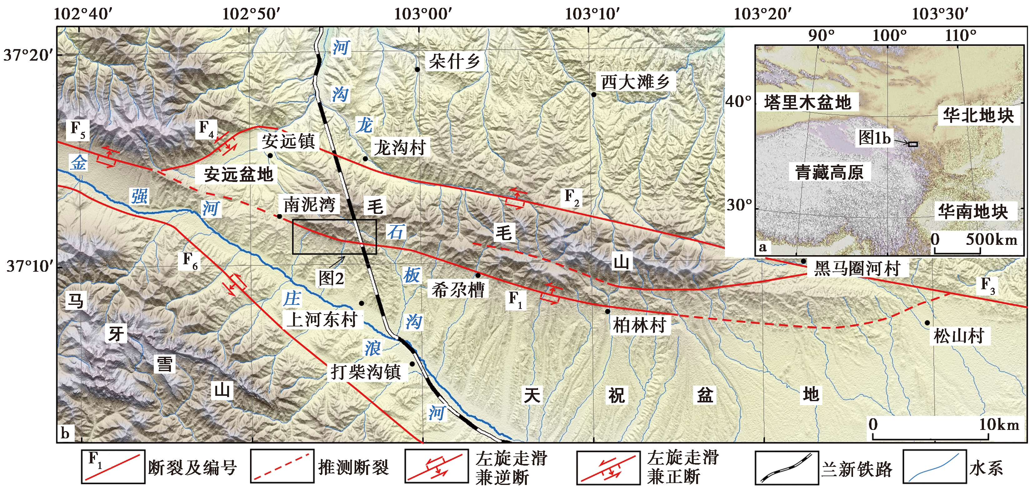
Fig. 1 Fault distribution map around Maomaoshan Mountain.
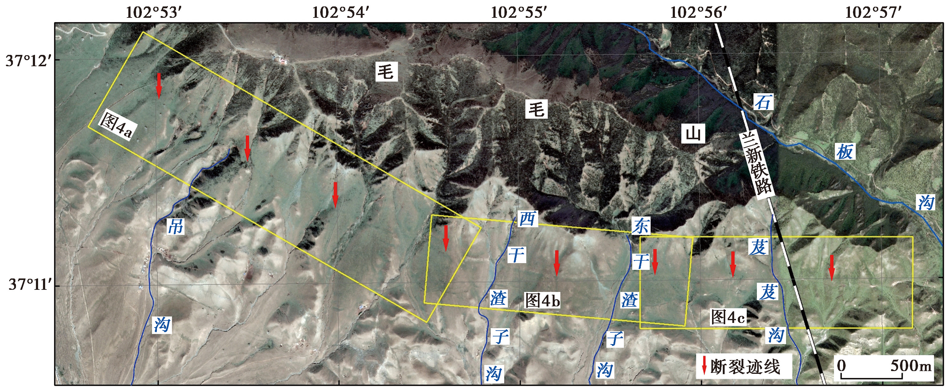
Fig. 2 Satellite imagery of the area from Shibangou to Nanniwan.
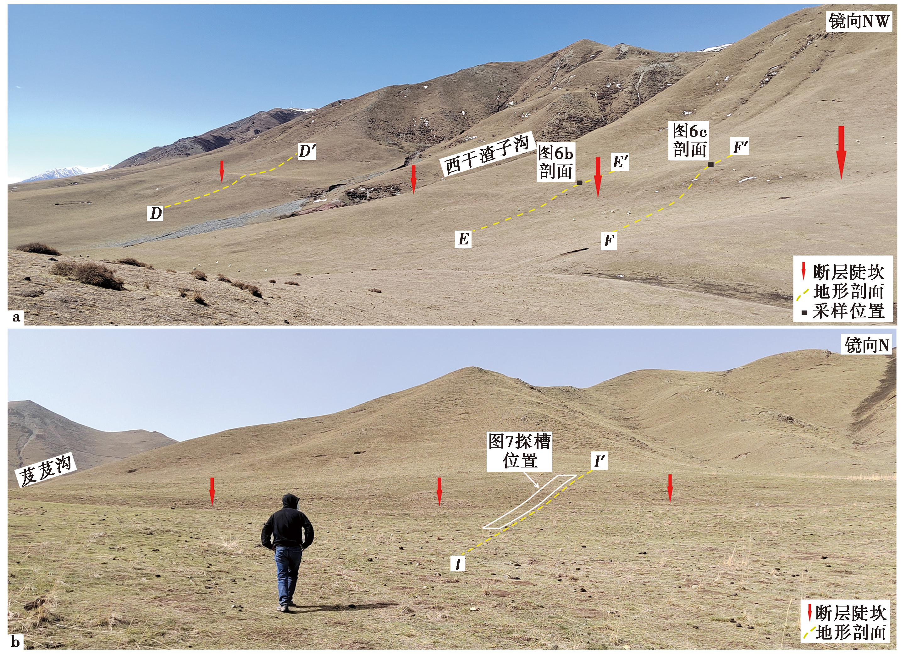
Fig. 3 Geomorphic photos of the Xiganzhazigou and Jijigou area.
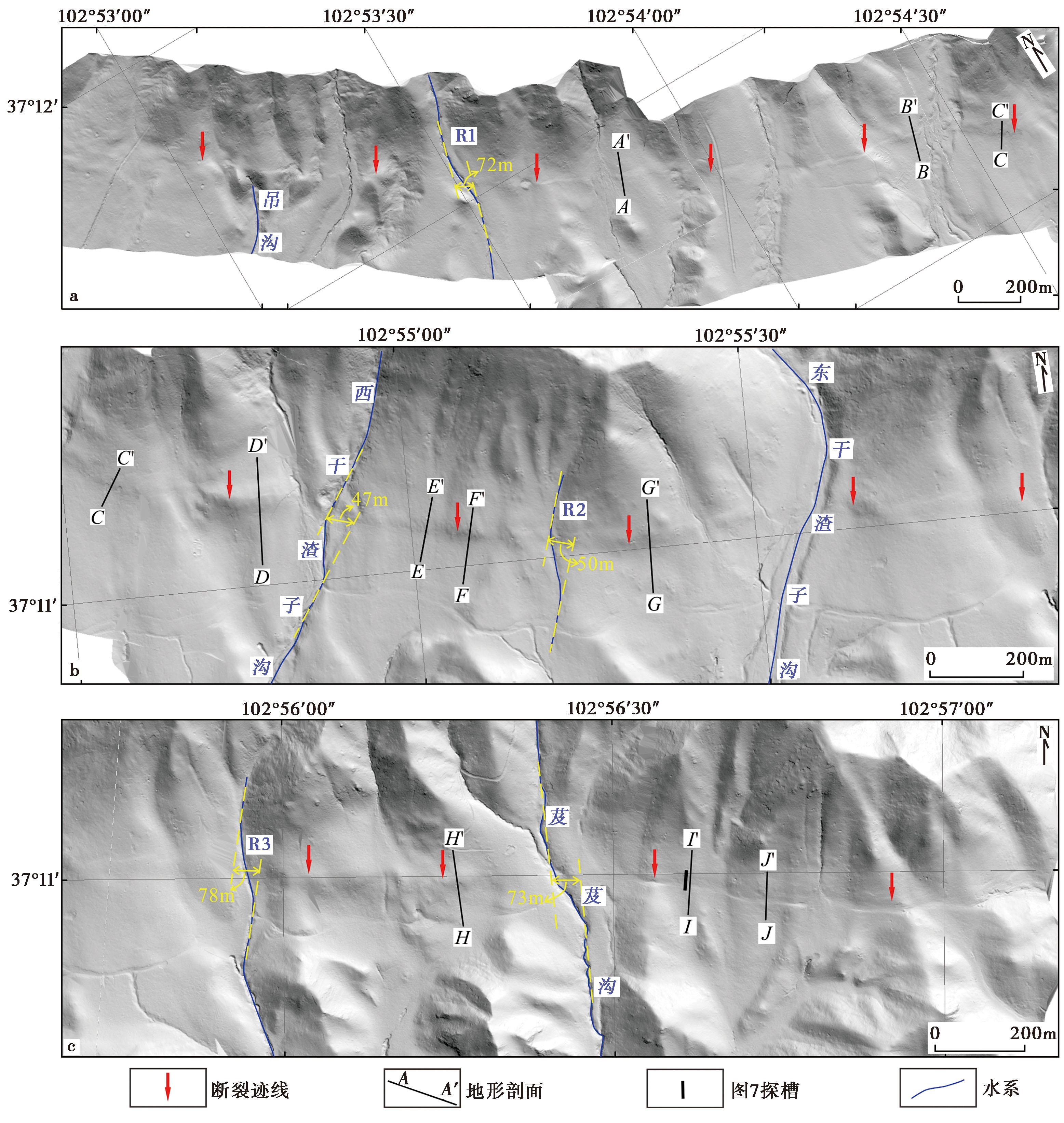
Fig. 4 DEM along the fault from Shibangou to Nanniwan.
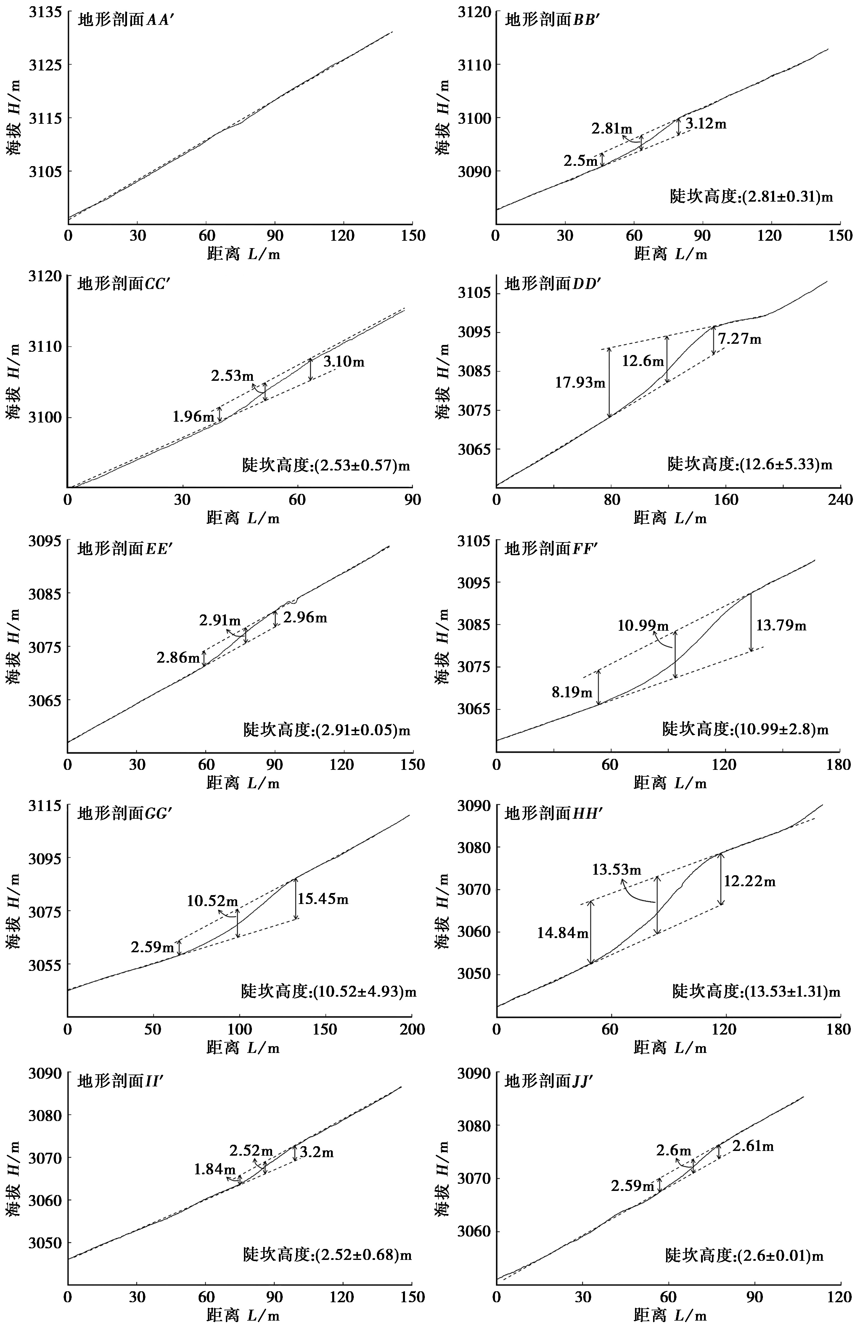
Fig. 5 Measurement of vertical height of steep scarps at typical locations of the study area.

Fig. 6 Sampling profiles of typical geomorphic surface.
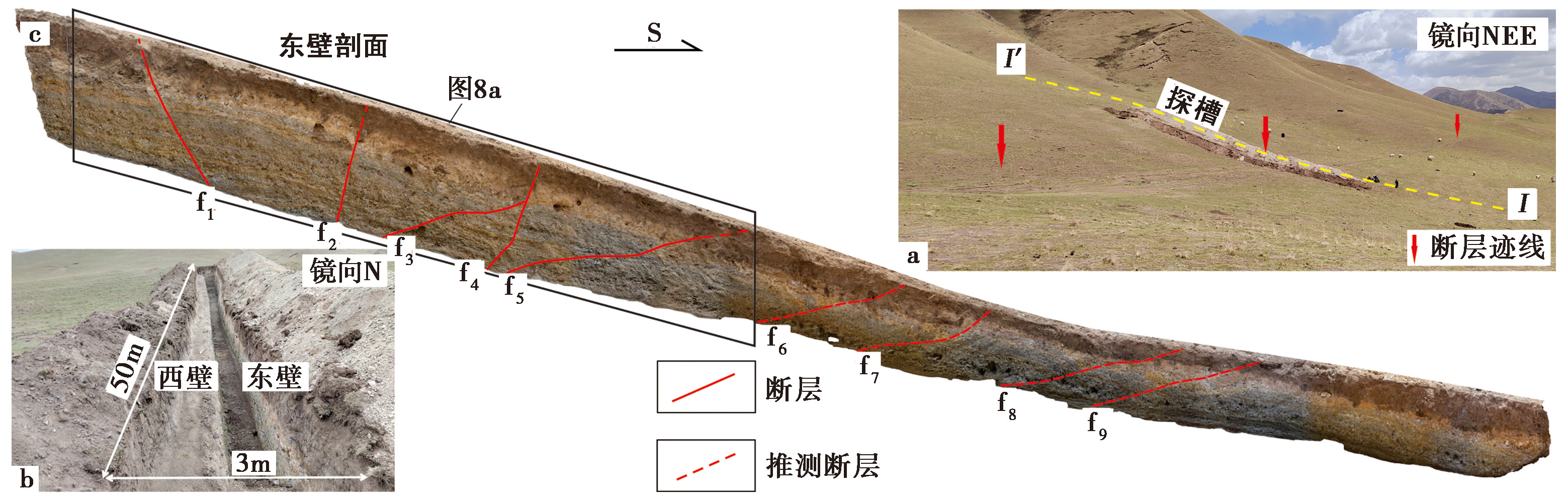
Fig. 7 Trench excavation at topographical profile II' east of Jijigou(a, b) and trench east wall profile(c).
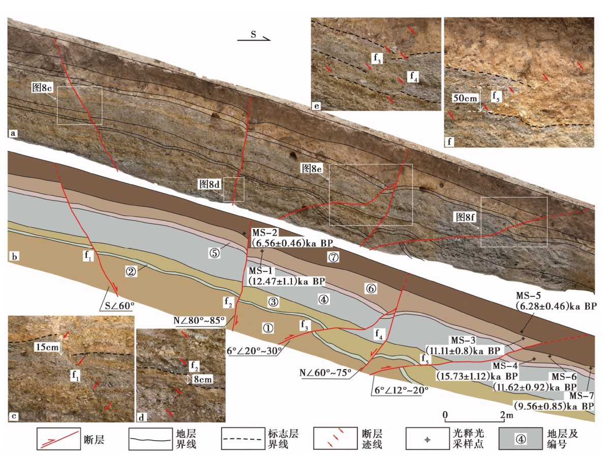
Fig. 8 Stitched photos of the east wall of the trench and its interpretation map.
| 样品 编号 | 埋深 /m | U /μg·g-1 | Th /μg·g-1 | K /% | 含水量 /% | 环境剂量率 /Gy·ka-1 | 等效剂量 /Gy | 年龄 /kaBP |
|---|---|---|---|---|---|---|---|---|
| MS-1 | 0.98 | 2.36±0.02 | 10.5±0.16 | 1.36±0.02 | 7.32 | 3.37±0.23 | 42.03±2.38 | 12.47±1.1 |
| MS-2 | 0.65 | 2.49±0.04 | 13.6±0.31 | 1.78±0.02 | 11.66 | 3.95±0.26 | 25.88±0.67 | 6.56±0.46 |
| MS-3 | 0.80 | 2.75±0.07 | 14.4±0.27 | 1.8±0.01 | 10.97 | 4.14±0.27 | 45.97±1.31 | 11.11±0.8 |
| MS-4 | 1.38 | 2.27±0.02 | 9.28±0.08 | 1.29±0.02 | 7.29 | 3.14±0.21 | 49.35±1.14 | 15.73±1.12 |
| MS-5 | 0.50 | 2.52±0.05 | 14.2±0.26 | 1.79±0.02 | 13.89 | 3.95±0.25 | 24.78±0.94 | 6.28±0.46 |
| MS-6 | 1.18 | 2.42±0.04 | 12.6±0.15 | 1.62±0.02 | 12.97 | 3.61±0.23 | 41.98±1.92 | 11.62±0.92 |
| MS-7 | 1.10 | 2.16±0.06 | 11±0.24 | 1.48±0.01 | 10.04 | 3.36±0.22 | 32.16±1.92 | 9.56±0.85 |
| MS-9 | 1.00 | 2.34±0.04 | 12.6±0.14 | 1.69±0.01 | 10.43 | 3.76±0.25 | 39.08±1.35 | 10.41±0.78 |
| MS-14 | 1.00 | 2.72±0.07 | 14.8±0.43 | 1.96±0.02 | 19.56 | 3.96±0.24 | 22.49±0.95 | 5.68±0.42 |
| MS-15 | 0.45 | 2.63±0.02 | 14.4±0.19 | 1.74±0.01 | 16.54 | 3.86±0.24 | 19.73±0.89 | 5.11±0.39 |
| MS-16 | 0.85 | 2.27±0.02 | 11.8±0.18 | 1.58±0.01 | 6.56 | 3.71±0.25 | 42.96±3.58 | 11.58±1.25 |
Table 1 OSL test parameters and age of samples
| 样品 编号 | 埋深 /m | U /μg·g-1 | Th /μg·g-1 | K /% | 含水量 /% | 环境剂量率 /Gy·ka-1 | 等效剂量 /Gy | 年龄 /kaBP |
|---|---|---|---|---|---|---|---|---|
| MS-1 | 0.98 | 2.36±0.02 | 10.5±0.16 | 1.36±0.02 | 7.32 | 3.37±0.23 | 42.03±2.38 | 12.47±1.1 |
| MS-2 | 0.65 | 2.49±0.04 | 13.6±0.31 | 1.78±0.02 | 11.66 | 3.95±0.26 | 25.88±0.67 | 6.56±0.46 |
| MS-3 | 0.80 | 2.75±0.07 | 14.4±0.27 | 1.8±0.01 | 10.97 | 4.14±0.27 | 45.97±1.31 | 11.11±0.8 |
| MS-4 | 1.38 | 2.27±0.02 | 9.28±0.08 | 1.29±0.02 | 7.29 | 3.14±0.21 | 49.35±1.14 | 15.73±1.12 |
| MS-5 | 0.50 | 2.52±0.05 | 14.2±0.26 | 1.79±0.02 | 13.89 | 3.95±0.25 | 24.78±0.94 | 6.28±0.46 |
| MS-6 | 1.18 | 2.42±0.04 | 12.6±0.15 | 1.62±0.02 | 12.97 | 3.61±0.23 | 41.98±1.92 | 11.62±0.92 |
| MS-7 | 1.10 | 2.16±0.06 | 11±0.24 | 1.48±0.01 | 10.04 | 3.36±0.22 | 32.16±1.92 | 9.56±0.85 |
| MS-9 | 1.00 | 2.34±0.04 | 12.6±0.14 | 1.69±0.01 | 10.43 | 3.76±0.25 | 39.08±1.35 | 10.41±0.78 |
| MS-14 | 1.00 | 2.72±0.07 | 14.8±0.43 | 1.96±0.02 | 19.56 | 3.96±0.24 | 22.49±0.95 | 5.68±0.42 |
| MS-15 | 0.45 | 2.63±0.02 | 14.4±0.19 | 1.74±0.01 | 16.54 | 3.86±0.24 | 19.73±0.89 | 5.11±0.39 |
| MS-16 | 0.85 | 2.27±0.02 | 11.8±0.18 | 1.58±0.01 | 6.56 | 3.71±0.25 | 42.96±3.58 | 11.58±1.25 |
| [1] |
崔笃信, 王庆良, 胡亚轩, 等. 2009. 用GPS数据反演海原断裂带断层滑动速率和闭锁深度[J]. 地震学报, 31(5): 516—525.
|
|
|
|
| [2] |
邓起东, 陈立春, 冉勇康. 2004. 活动构造定量研究与应用[J]. 地学前缘, 11(4): 383—392.
|
|
|
|
| [3] |
郝明, 李煜航, 秦姗兰. 2017. 基于GPS数据的海原-六盘山断裂带滑动速率亏损时空分布[J]. 地震地质, 39(3): 471—484. doi: 10.3969/j.issn.0253-4967.2017.03.003.
|
|
|
|
| [4] |
胡亚轩, 崔笃信, 张希, 等. 2009. 用GPS数据反演分析海原断裂带分段活动特征[J]. 西北地震学报, 31(3): 227—230.
|
|
|
|
| [5] |
胡亚轩, 崔笃信, 祝意青. 2010. 跨祁连山-海原断裂带综合观测剖面资料分析[J]. 中国地震, 26(4): 391—400.
|
|
|
|
| [6] |
黄伟亮, 杨晓平, 李胜强, 等. 2018. 焉耆盆地北缘断裂全新世滑动速率及地震危险性[J]. 地震地质, 40(1): 186—203. doi: 10.3969/j.issn.0253-4967.2018.01.014.
|
|
|
|
| [7] |
康帅, 张景发, 崔效峰, 等. 2017. 基于高精度地基LiDAR技术的活动断层错断地貌研究: 以冷龙岭活动断裂带为例[J]. 地震, 37(3): 61—71.
|
|
|
|
| [8] |
李强, 江在森, 武艳强, 等. 2014. 利用GPS资料反演海原-六盘山断裂带闭锁程度与滑动亏损分布[J]. 武汉大学学报(信息科学版), 39(5): 575—580.
|
|
|
|
| [9] |
李延川. 2016. 基于GPS的海原断裂变形特征及强震危险性分析[D]. 青岛: 中国石油大学.
|
|
|
|
| [10] |
梁淑敏, 郑文俊, 陈干, 等. 2019. 祁连-海原断裂带金强河段晚第四纪运动特征及其构造意义[C]. 2019年中国地球科学联合学术年会.
|
|
|
|
| [11] |
刘百篪, 吕太乙, 袁道阳, 等. 2013. 祁连山活动断裂东段(老虎山、 毛毛山和金强河断裂)地质图[CM]. 北京: 地震出版社.
|
|
|
|
| [12] |
刘静, 袁兆德, 徐岳仁, 等. 2021. 古地震学: 活动断裂强震复发规律的研究[J]. 地学前缘, 28(2): 211—231.
|
|
|
|
| [13] |
刘雷, 朱良玉, 庄文泉. 2022. 2022年门源 MS6.9 地震前祁连-海原断裂带闭锁程度研究[J]. 地震地磁观测与研究, 43(S1): 433—436.
|
|
|
|
| [14] |
吕德徽, 向光中, 才树华, 等. 1994. 毛毛山断裂带断层岩的特征及其意义[J]. 内陆地震, 8(2): 159—165.
|
|
|
|
| [15] |
乔鑫, 屈春燕, 单新建, 等. 2019. 基于时序InSAR的海原断裂带形变特征及运动学参数反演[J]. 地震地质, 41(6): 1481—1496. doi: 10.3969/j.issn.0253-4967.2019.06.011.
|
|
|
|
| [16] |
冉勇康, 王虎, 李彦宝, 等. 2012. 中国大陆古地震研究的关键技术与案例解析(1): 走滑活动断裂的探槽地点、 布设与事件识别标志[J]. 地震地质, 34(2): 197—210. doi: 10.3969/j.issn.0253-4967.2012.02.001.
|
|
|
|
| [17] |
任治坤, 陈涛, 张会平, 等. 2014. LiDAR技术在活动构造研究中的应用[J]. 地质学报, 88(6): 1196—1207.
|
|
|
|
| [18] |
孙郝, 徐晶, 柳皓元. 2017. 基于InSAR的广义海原断裂带中东段现今深部运动特征[J]. 大地测量与地球动力学, 37(11): 1141—1145.
|
|
|
|
| [19] |
唐清, 郑文俊, 石霖, 等. 2020. 基于高精度LiDAR数据的断裂活动习性精细定量: 以香山-天景山断裂景泰小红山段为例[J]. 地震地质, 42(2): 366—381. doi: 10.3969/j.issn.0253-4967.2020.02.008.
|
|
|
|
| [20] |
王永成, 刘百篪. 2001. 祁连山中东段断裂的地震危险性分析[J]. 西北地震学报, 23(4): 330—338.
|
|
|
|
| [21] |
吴东霖, 葛伟鹏, 魏聪敏. 2020. 利用Sentinel-1合成孔径雷达干涉测量技术监测海原断裂现今地壳变形特征[J]. 地震工程学报, 42(5): 1055—1064.
|
|
|
|
| [22] |
杨海波, 杨晓平, 黄雄南. 2017. 祁连山北缘断裂带中段晚第四纪活动速率初步研究[J]. 地震地质, 39(1): 20—42. doi: 10.3969/j.issn.0253-4967.2017.01.002.
|
|
|
|
| [23] |
杨源源, 李鹏飞, 路硕, 等. 2022. 郯庐断裂带中段F5断裂淮河—女山湖段的古地震与垂直滑动速率[J]. 地震地质, 44(6): 1365—1383. doi: 10.3969/j.issn.0253-4967.2022.06.002.
|
|
|
|
| [24] |
姚文倩. 2019. 海原断裂老虎山段及其邻区晚第四纪活动性及几何复杂度研究[D]. 北京: 中国地震局地质研究所.
|
|
|
|
| [25] |
俞晶星. 2013. 雅布赖山前断裂晚第四纪滑动速率与古地震[D]. 北京: 中国地震局地质研究所.
|
|
|
|
| [26] |
袁道阳, 刘百篪, 吕太乙, 等. 1996. 毛毛山断裂带位移累积滑动亏损特征及其分段意义讨论[J]. 西北地震学报, 18(4): 59—67.
|
|
|
|
| [27] |
袁道阳, 刘百篪, 吕太乙, 等. 1997. 利用黄土剖面的古土壤年龄研究毛毛山断裂的滑动速率[J]. 地震地质, 19(1): 1—8.
|
|
|
|
| [28] |
袁道阳, 刘百篪, 吕太乙, 等. 1998. 北祁连山东段活动断裂带的分段性研究[J]. 西北地震学报, 20(4): 27—34.
|
|
|
|
| [29] |
张会平, 张培震, 郑德文, 等. 2012. 祁连山构造地貌特征: 青藏高原东北缘晚新生代构造变形和地貌演化过程的启示[J]. 第四纪研究, 32(5): 907—920.
|
|
|
|
| [30] |
张培震, 李传友, 毛凤英. 2008. 河流阶地演化与走滑断裂滑动速率[J]. 地震地质, 30(1): 44—57.
|
|
|
|
| [31] |
郑文俊, 袁道阳, 何文贵. 2004. 祁连山中东段强震复发概率模型及未来强震地点预测[J]. 西北地震学报, 26(3): 228—233.
|
|
|
|
| [32] |
朱琳, 戴勇, 石富强, 等. 2022. 祁连-海原断裂带库伦应力演化及地震危险性[J]. 地震学报, 44(2): 223—236.
|
|
|
|
| [33] |
|
| [34] |
|
| [1] | CHANG Yu-qiao, ZHANG Hui-ping, ZHAO Xu-dong. RESEARCH ADVANCES OF THE LATE QUATERNARY ACTIVITY OF XIAOJIANG FAULT ZONE IN THE SOUTHEASTERN MARGIN OF QINGHAI-XIZANG PLATEAU [J]. SEISMOLOGY AND GEOLOGY, 2026, 48(2): 279-313. |
| [2] | LUO Jia-xin, LI Bin, LI Zi-hong, FAN Kun. CHARACTERISTICS OF VERTICAL SLIP RATE EVOLUTION ALONG THE JIAOCHENG FAULT ZONE, SHANXI, SINCE LATE PLEISTOCENE [J]. SEISMOLOGY AND GEOLOGY, 2026, 48(1): 43-63. |
| [3] | CHEN Yan-wen, YUAN Dao-yang, YAO Yun-sheng, YU Jin-chao, WEN Ya-meng, SU Rui-huan, SUN Hao. CHARACTERISTICS OF LATE QUATERNARY ACTIVITY AND TECTONIC IMPLICATIONS OF THE MAYAXUESHAN FAULT IN THE EASTERN QILIAN SHAN [J]. SEISMOLOGY AND GEOLOGY, 2025, 47(6): 1566-1585. |
| [4] | GAO Yang, WU Zhong-hai, HAN Shuai, TIAN Ting-ting. LATE QUATERNARY THROW RATE OF THE SEISMOGENIC FAULT(DENGMECUO FAULT)OF THE 2025 MS6.8 DINGRI EARTHQUAKE IN SHIGATSE [J]. SEISMOLOGY AND GEOLOGY, 2025, 47(3): 689-706. |
| [5] | WANG Duo, CHEN Li-chun, LI Yan-bao, WANG Hu, JIA Yong-shun, GAO Yin-yi, XUE Ke-yi. LATE QUATERNARY ACTIVITY OF THE XIETONGMEN TO DENGMECUO SEGMENT ALONG THE XAINZA-DINGGYE RIFT IN SOUTHERN QINGHAI-XIZANG PLATEAU [J]. SEISMOLOGY AND GEOLOGY, 2025, 47(3): 718-733. |
| [6] | CHEN Chang-yun, YIN Hai-quan. CRUSTAL DEFORMATION CHARACTERISTICS AND PROBABILITY PREDICTION OF STRONG EARTHQUAKE RISK IN XINJIANG AND ITS ADJACENT REGION [J]. SEISMOLOGY AND GEOLOGY, 2025, 47(2): 384-404. |
| [7] | ZHU Shuang, GUO Nan-nan, PANG Ya-jin. STUDY ON FAULT DEFORMATION CHARACTERISTICS AND SEISMIC HAZARD IN THE KEPING THRUST BELT [J]. SEISMOLOGY AND GEOLOGY, 2025, 47(2): 448-462. |
| [8] | XU Bin-bin, ZHANG Yi-peng, LU Le-jun, TIAN Qing-ying, YANG Xue, WANG Yang, ZHANG Pei-zhen. STUDY ON SEISMOGENIC TECTONICS OF THE 2025 MYANMAR MS7.9 EARTHQUAKE [J]. SEISMOLOGY AND GEOLOGY, 2025, 47(2): 649-670. |
| [9] | ZANG Ke-zhi, WU Chuan-yong, ZHANG Jin-shuo, GAO Zhan, YUAN Si-hua, YUAN Hai-yang, YU Xiao-hui, WANG Xue-zhu. LATE QUATERNARY DEFORMATION RATE OF THE WENSU FORELAND THRUST BELT IN THE SOUTHERN TIANSHAN MOUNTAINS [J]. SEISMOLOGY AND GEOLOGY, 2024, 46(6): 1280-1294. |
| [10] | HUA Chun-yu, SHI Feng, WEI Zhan-yu. STUDY ON THE SLIP RATE OF THE BAISHA RIVER SEGMENT IN THE YINGXIU-BEICHUAN FAULT IN THE LONGMENSHAN FAULT ZONE [J]. SEISMOLOGY AND GEOLOGY, 2024, 46(6): 1295-1313. |
| [11] | CHEN Bai-xu, YU Zhong-yuan, XIAO Peng, DAI Xun-ye, ZHANG Shi-long, ZHENG Rong-ying. THE NEW FINDINGS OF SURFACE RUPTURE ZONES AND ITS SEISMOLOGICAL SIGNIFICANCE OF THE EASTERN MARGIN OF YUMUSHAN FAULT, NORTHEASTERN MARGIN OF QINGZANG PLATEAU [J]. SEISMOLOGY AND GEOLOGY, 2024, 46(3): 589-607. |
| [12] | HUANG Wei-liang, ZHANG Jia-le, XIANG Wen, YANG Qian-hao. THE LATE QUATERNARY ACTIVITY CHARACTERISTICS AND SLIP RATE OF BATANG FAULT IN SE TIBETAN PLATEAU [J]. SEISMOLOGY AND GEOLOGY, 2023, 45(6): 1265-1285. |
| [13] | CHEN Yi, ZHAO Bin, XIONG Wei, WANG Wei, YU Peng-fei, YU Jian-sheng, WANG Dong-zhen, CHEN Wei, QIAO Xue-jun. INTERSEISMIC SLIP RATES AND SHALLOW CREEP ALONG THE NORTHWESTERN SEGMENT OF THE XIANSHUIHE FAULT FROM INSAR DATA [J]. SEISMOLOGY AND GEOLOGY, 2023, 45(5): 1074-1091. |
| [14] | LIU Qing, LIU Shao, ZHANG Shi-min. PALEOSEISMOLOGIC STUDY ON THE YUEXI FAULT IN THE MIDSECTION OF THE DALIANGSHAN FAULT ZONE SINCE THE LATE QUATERNARY [J]. SEISMOLOGY AND GEOLOGY, 2023, 45(2): 321-337. |
| [15] | YUAN Hao-dong, LI An, HUANG Wei-liang, HU Zong-kai, ZUO Yu-qi, YANG Xiao-ping. GEOLOGICAL DEFORMATION OF THE TUOLI FAULT IN THE WEST JUNGGAR SINCE THE LATE QUATERNARY [J]. SEISMOLOGY AND GEOLOGY, 2023, 45(1): 49-66. |
| Viewed | ||||||
|
Full text |
|
|||||
|
Abstract |
|
|||||
Copyright © SEISMOLOGY AND GEOLOGY, All Rights Reserved.
Tel: 010-62009049/9063 E-mail: dzdz@ies.ac.cn
Powered by Beijing Magtech Co., Ltd.