
SEISMOLOGY AND EGOLOGY ›› 2022, Vol. 44 ›› Issue (1): 220-237.DOI: 10.3969/j.issn.0253-4967.2022.01.014
• Research paper • Previous Articles Next Articles
STUDY ON THE SEISMOTECTONICS OF THE QINGBAIJIANG MS5.1 EARTHQUAKE IN SICHUAN PROVINCE IN 2020 BY MULTIPLE CONSTRAINT METHOD
XU Fang1)( ), LU Ren-qi1),*(), WANG Shuai2), JIANG Guo-yan3), LONG Feng4), WANG Xiao-shan5), SU Peng1), LIU Guan-shen1)
- 1) State Key Laboratory of Earthquake Dynamics, Institute of Geology, China Earthquake Administration, Beijing 100029, China
2) College of Geomatics Science and Technology, Nanjing Tech University, Nanjing 211800, China
3) School of Geodesy and Geomatics, Wuhan University, Wuhan 430079, China
4) Sichuan Earthquake Agency, Chengdu 610041, China
5) Hebei Earthquake Agency, Shijiazhuang 050021, China
-
Received:2021-01-15Revised:2021-04-27Online:2022-02-20Published:2022-04-20 -
Contact:LU Ren-qi
基于多元约束方法的2020年四川青白江MS5.1地震构造研究
徐芳1)(), 鲁人齐1),*(), 王帅2), 江国焰3), 龙锋4), 王晓山5), 苏鹏1), 刘冠伸1)
- 1)中国地震局地质研究所, 地震动力学国家重点实验室, 北京 100029
2)南京工业大学, 测绘科学与技术学院, 南京 211800
3)武汉大学, 测绘学院, 武汉 430079
4)四川省地震局, 成都 610041
5)河北省地震局, 石家庄 050021
-
通讯作者:鲁人齐 -
作者简介:徐芳, 女, 1997年生, 2019年于合肥工业大学获地质学学士学位, 现为中国地震局地质研究所构造地质学专业在读硕士研究生, 主要从事活动构造分析与三维建模研究, E-mail: xufangq@sina.cn。 -
基金资助:国家自然科学基金(41872206);国家重点研发计划项目(2021YFC3000604)
CLC Number:
Cite this article
XU Fang, LU Ren-qi, WANG Shuai, JIANG Guo-yan, LONG Feng, WANG Xiao-shan, SU Peng, LIU Guan-shen. STUDY ON THE SEISMOTECTONICS OF THE QINGBAIJIANG MS5.1 EARTHQUAKE IN SICHUAN PROVINCE IN 2020 BY MULTIPLE CONSTRAINT METHOD[J]. SEISMOLOGY AND EGOLOGY, 2022, 44(1): 220-237.
徐芳, 鲁人齐, 王帅, 江国焰, 龙锋, 王晓山, 苏鹏, 刘冠伸. 基于多元约束方法的2020年四川青白江MS5.1地震构造研究[J]. 地震地质, 2022, 44(1): 220-237.
share this article
Add to citation manager EndNote|Ris|BibTeX
URL: https://www.dzdz.ac.cn/EN/10.3969/j.issn.0253-4967.2022.01.014
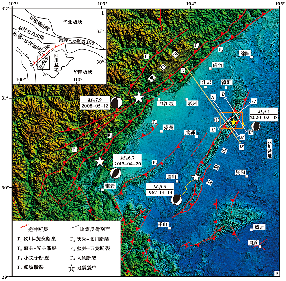
Fig. 1 Tectonic background of Longmenshan-Longquanshan main fault zone and its surrounding area.
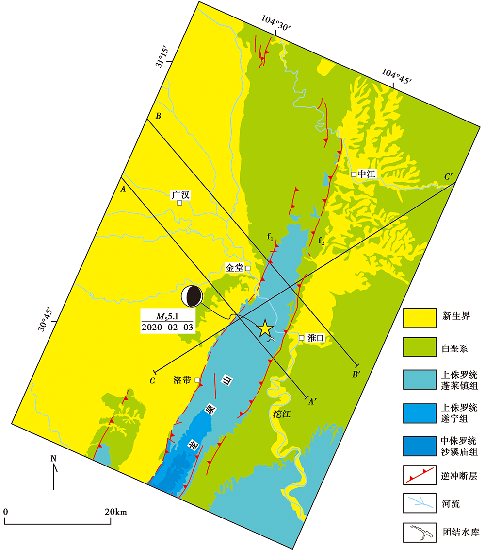
Fig. 2 The 1︰200 000 geological map of north segment and surrounding area of Longquanshan fault zone (Revised from LU Ren-qi et al., 2010).
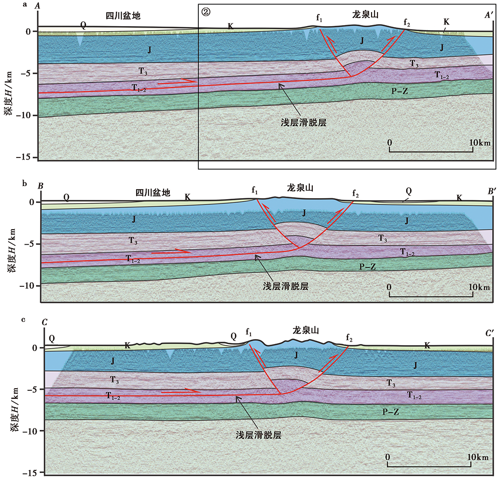
Fig. 3 Interpretation of petroleum seismic reflection profile in the north segment of Longquanshan.
| 机构或学者 | 位置 | 节面Ⅰ | 节面Ⅱ | 深度 /km | 震级 | |||||
|---|---|---|---|---|---|---|---|---|---|---|
| 东经 /(°) | 北纬 /(°) | 走向 /(°) | 倾角 /(°) | 滑动角 /(°) | 走向 /(°) | 倾角 /(°) | 滑动角 /(°) | |||
| Lei et al., | 104.46 | 30.74 | 15 | 36 | 82 | 205 | 54 | 96 | 3.3 | MS5.1 |
| GCMT, | 104.54 | 30.57 | 30 | 33 | 114 | 183 | 60 | 75 | 12.5 | MS4.8 |
| 中国地震台网中心, | 104.46 | 30.74 | 21 | MS5.1 | ||||||
| USGS, | 104.54 | 30.76 | 45 | 77 | 105 | 175 | 19 | 41 | 10 | MW4.8 |
| 韩颜颜等, | 104.46 | 30.74 | 25 | 34 | 100 | 193 | 57 | 83 | 5 | MW4.8 |
| 本文 | 104.48 | 30.73 | 18 | 32 | 100 | 186 | 59 | 84 | 5 | MW4.6 |
Table 1 Focal mechanism of the MS5.1 Qingbaijiang earthquake
| 机构或学者 | 位置 | 节面Ⅰ | 节面Ⅱ | 深度 /km | 震级 | |||||
|---|---|---|---|---|---|---|---|---|---|---|
| 东经 /(°) | 北纬 /(°) | 走向 /(°) | 倾角 /(°) | 滑动角 /(°) | 走向 /(°) | 倾角 /(°) | 滑动角 /(°) | |||
| Lei et al., | 104.46 | 30.74 | 15 | 36 | 82 | 205 | 54 | 96 | 3.3 | MS5.1 |
| GCMT, | 104.54 | 30.57 | 30 | 33 | 114 | 183 | 60 | 75 | 12.5 | MS4.8 |
| 中国地震台网中心, | 104.46 | 30.74 | 21 | MS5.1 | ||||||
| USGS, | 104.54 | 30.76 | 45 | 77 | 105 | 175 | 19 | 41 | 10 | MW4.8 |
| 韩颜颜等, | 104.46 | 30.74 | 25 | 34 | 100 | 193 | 57 | 83 | 5 | MW4.8 |
| 本文 | 104.48 | 30.73 | 18 | 32 | 100 | 186 | 59 | 84 | 5 | MW4.6 |
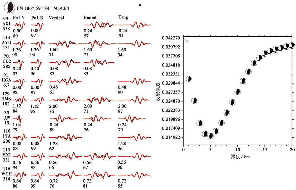
Fig. 4 Waveform fitting and focal mechanism for the MS5.1 Qingbaijiang earthquake.
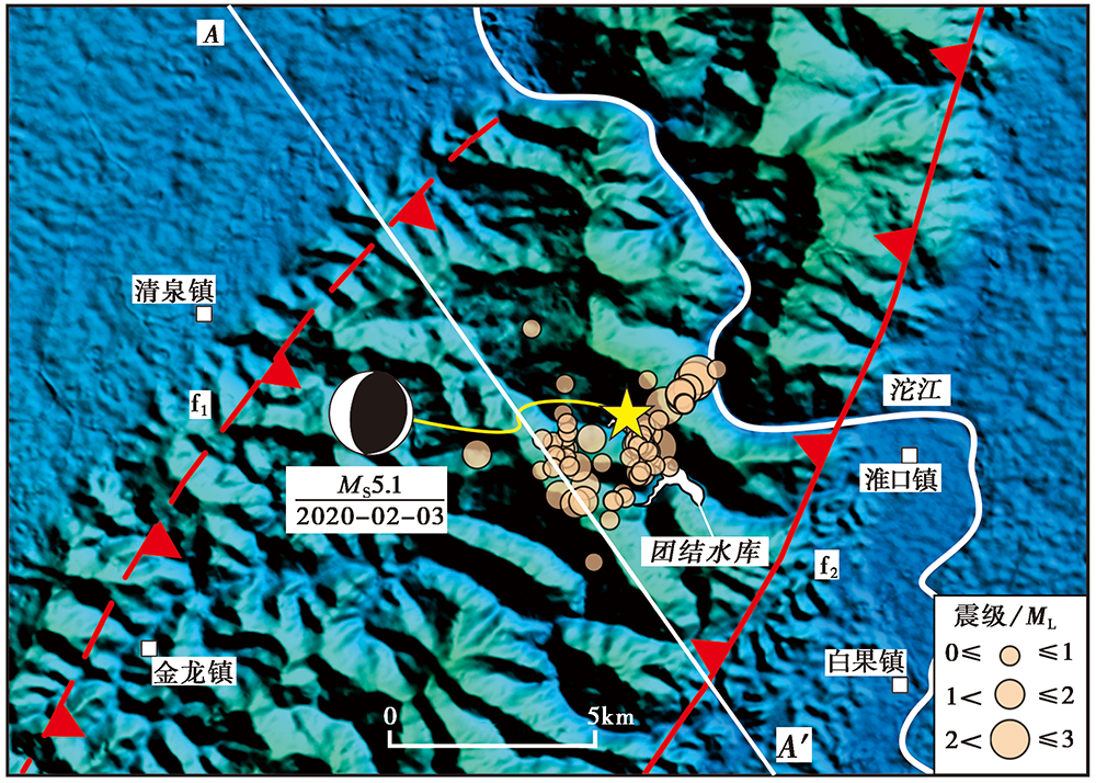
Fig. 5 Plane distribution of main shock and aftershock of Qingbaijiang earthquake in 2020.
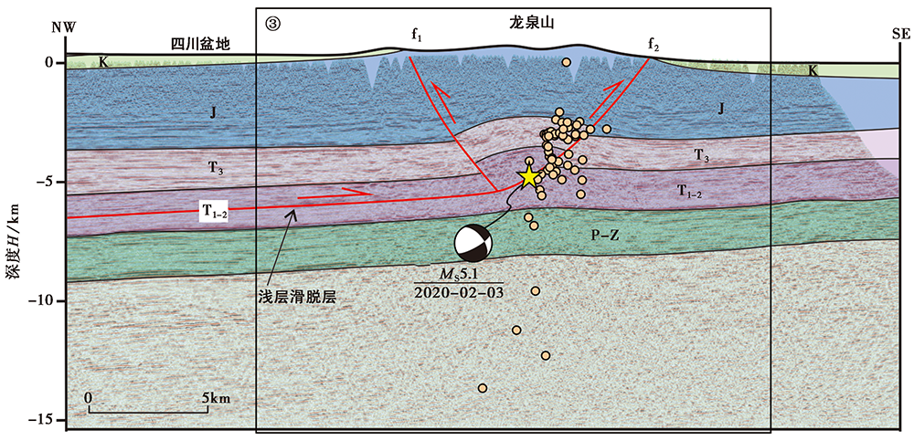
Fig. 6 The vertical distribution of the main shock and aftershocks of Qingbaijiang earthquake in 2020.
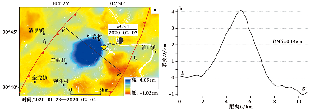
Fig. 7 Processing results of orbit 55 data of Sentinel-1 satellite in the study area.

Fig. 8 Processing results of orbit 62 data of Sentinel-1 satellite in the study area.
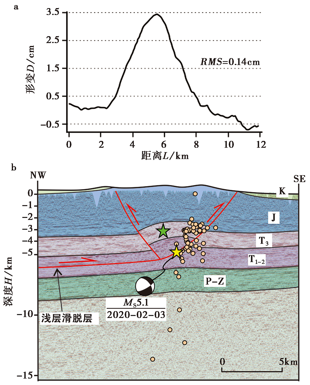
Fig. 9 Seismotectonics analysis of the MS5.1 Qingbaijiang earthquake in 2020.
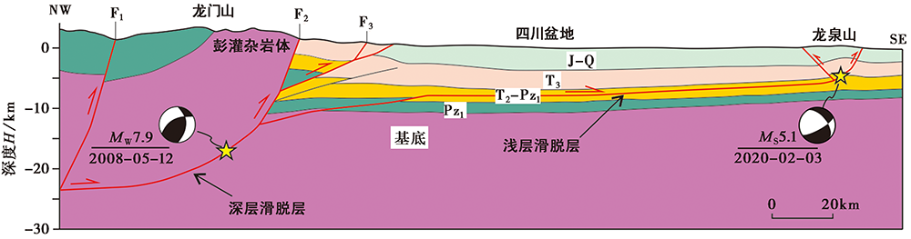
Fig. 10 The geological and seismotectonic model of the Longmenshan and Longquanshan region.
| [1] | 曹伟. 1994. 龙门山推覆构造带中段前缘构造浅析[J]. 石油实验地质, 16(1): 35-42. |
| CAO Wei. 1994. On the overthrusting tectonics of the front margin along the middle section of the Longmenshan tectonic belt[J]. Experimental Petroleum Geology, 16(1): 35-42. (in Chinese) | |
| [2] | 陈社发, 邓起东, 赵小麟, 等. 1994. 龙门山中段推覆构造带及相关构造的演化历史和变形机制(二)[J]. 地震地质, 16(4): 413-421. |
| CHEN She-fa, DENG Qi-dong, ZHAO Xiao-lin, et al. 1994. Deformational characteristics, evolutionary history, and deformation mechanism of the middle Longmenshan thrust-nappes and related tectonics[J]. Seismology and Geology, 16(4): 413-421. (in Chinese) | |
| [3] | 陈竹新, 王丽宁, 杨光, 等. 2020. 川西南冲断带深层地质构造与潜在油气勘探领域[J]. 石油勘探与开发, 47(4): 653-667. |
| CHEN Zhu-xin, WANG Li-ning, YANG Guang, et al. 2020. Geological structures and potential petroleum exploration areas in the southwestern Sichuan fold-thrust belt, SW China[J]. Petroleum Exploration and Development, 47(4): 653-667. (in Chinese) | |
| [4] | 邓起东, 陈社发, 赵小麟. 1994. 龙门山及其邻区的构造和地震活动及动力学[J]. 地震地质, 16(4): 389-403. |
| DENG Qi-dong, CHEN She-fa, ZHAO Xiao-lin. 1994. Tectonics, seismicity and dynamics of Longmenshan Mountains and its adjacent regions[J]. Seismology and Geology, 16(4): 389-403. (in Chinese) | |
| [5] | 国家地震科学数据中心. 2020. 中国台网正式地震目录[EB/OL]. [2020-11-01]. https://data.earthquake.cn/datashare/report.shtml?PAGEID=earthquake_zhengshi. |
| National Earthquake Data Center. 2020. Official earthquake catalogue of China Network[EB/OL]. [2020-11-01]. https://data.earthquake.cn/datashare/report.shtml?PAGEID=earthquake_zhengshi. (in Chinese) | |
| [6] | 韩颜颜, 马亚伟, 解孟雨, 等. 2020. 2020年2月3日四川青白江5.1级地震总结[J]. 地震地磁观测与研究, 41(5): 141-152. |
| HAN Yan-yan, MA Ya-wei, XIE Meng-yu, et al. 2020. Summary of Qingbaijiang MS5.1 earthquake in Sichuan on February 3, 2020[J]. Seismological and Geomagnetic Observation and Research, 41(5): 141-152. (in Chinese) | |
| [7] | 黄伟, 江娃利. 2012. 四川龙泉山断裂带及其活动性与潜在地震危险性讨论[J]. 西北地震学报, 34(1): 50-56. |
| HUANG Wei, JIANG Wa-li. 2012. Discussion on the Late Quaternary activity and earthquake risk potential of Longquanshan Fault in Sichuan[J]. Northwestern Seismological Journal, 34(1): 50-56. (in Chinese) | |
| [8] | 黄祖智, 唐荣昌. 1995. 龙泉山活动断裂带及其潜在地震能力的探讨[J]. 四川地震, (1): 18-23. |
| HUANG Zu-zhi, TANG Rong-chang. 1995. The Longquanshan fault zone and exploration of potential earthquake ability[J]. Earthquake Research in Sichuan, (1): 18-23. (in Chinese) | |
| [9] | 李洪奎, 李忠权, 龙伟, 等. 2019. 四川盆地纵向结构及原型盆地叠合特征[J]. 成都理工大学学报(自然科学版), 46(3): 257-267. |
| LI Hong-kui, LI Zhong-quan, LONG Wei, et al. 2019. Vertical configuration of Sichuan Basin and its superimposed characteristics of the prototype basin[J]. Journal of Chengdu University of Technology(Science & Technology Edition), 46(3): 257-267. (in Chinese) | |
| [10] | 刘亮, 梁斌, 燕中林, 等. 2019. 龙泉山断裂带隐伏断层氡气特征及其活动性分析[J]. 沉积与特提斯地质, 39(2): 45-53. |
| LIU Liang, LIANG Bin, YAN Zhong-lin, et al. 2019. Soil gas radon and fault activity in the Longquanshan fault zone, Sichuan[J]. Sedimentary Geology and Tethyan Geology, 39(2): 45-53. (in Chinese) | |
| [11] | 刘亮, 梁斌, 燕中林, 等. 2020. 龙泉山断裂带断层最新活动年代及方式[J]. 中国地质调查, 7(5): 77-87. |
| LIU Liang, LIANG Bin, YAN Zhong-lin, et al. 2020. Latest active age and model of the faults in Longquanshan fault belt[J]. Geological Survey of China, 7(5): 77-87. (in Chinese) | |
| [12] | 刘树根, 李智武, 曹俊兴, 等. 2009. 龙门山陆内复合造山带的四维结构构造特征[J]. 地质科学, 44(4): 1151-1180. |
| LIU Shu-gen, LI Zhi-wu, CAO Jun-xing, et al. 2009. 4-D textural and structural characteristics of Longmen intracontinental composite orogenic belt, southwest China[J]. Chinese Journal of Geology, 44(4): 1151-1180. (in Chinese) | |
| [13] | 刘树根, 罗志立, 赵锡奎, 等. 2003. 中国西部盆山系统的耦合关系及其动力学模式: 以龙门山造山带-川西前陆盆地系统为例[J]. 地质学报, 77(2): 177-186. |
| LIU Shu-gen, LUO Zhi-li, ZHAO Xi-kui, et al. 2003. Coupling relationships of sedimentary basin-orogenic belt systems and their dynamic models in West China: A case study of Longmenshan orogenic belt-West Sichuan foreland basin system[J]. Acta Geologica Sinica, 77(2): 177-186. (in Chinese) | |
| [14] | 鲁人齐, 何登发, Suppe J, 等. 2010. 龙门山中段山前带浅层冲断系统的结构、 形成与演化[J]. 地质科学, 45(4): 997-1010. |
| LU Ren-qi, HE Deng-fa, Suppe J, et al. 2010. The structures, formation and evolution of the shallow thrusting system in the central Longmen Mountains front belt[J]. Chinese Journal of Geology, 45(4): 997-1010. (in Chinese) | |
| [15] | 钱琦, 韩竹军. 2011. 汶川地震对龙泉山断裂地震发生概率的影响研究[J]. 地球物理学进展, 26(2): 489-497. |
| QIAN Qi, HAN Zhu-jun. 2011. The research in the change of the earthquake occurrence probability in Longquan Shan Fault after the Wenchuan earthquake[J]. Progress in Geophysics, 26(2): 489-497. (in Chinese) | |
| [16] | 四川省地震局. 2020. 2020年2月3日四川成都青白江5.1级地震烈度图分布及说明[EB/OL].(2020-02-04) [2020-12-28]. http://www.scdzj.gov.cn/xwzx/fzjzyw/202002/t20200204_12909.html. |
| Sichuan Earthquake Agency. 2020. Intensity map distribution and explanation of Qingbaijiang MS5.1 earthquake in Chengdu, Sichuan Province on February 3, 2020[EB/OL].(2020-02-04) [2020-12-28]. http://www.scdzj.gov.cn/xwzx/fzjzyw/202002/t20200204_12909.html. (in Chinese) | |
| [17] |
宋小刚, 申星, 姜宇, 等. 2015. 通过InSAR与GPS数据融合获取汶川地震同震三维形变场[J]. 地震地质, 37(1): 222-231. doi: 10.3969/j.issn.0253-4967.2015.01.017.
DOI |
| SONG Xiao-gang, SHEN Xing, JIANG Yu, et al. 2015. Coseismic 3D deformation field acquisition of the Wenchuan earthquake based on InSAR and GPS data[J]. Seismology and Geology, 37(1): 222-231. (in Chinese) | |
| [18] | 孙晓鹏, 鲁小丫, 文学虎, 等. 2016. 基于SBAS-InSAR的成都平原地面沉降监测[J]. 国土资源遥感, 28(3): 123-129. |
| SUN Xiao-peng, LU Xiao-ya, WEN Xue-hu, et al. 2016. Monitoring of ground subsidence in Chengdu Plain using SBAS-InSAR[J]. Remote Sensing for Land & Resources, 28(3): 123-129. (in Chinese) | |
| [19] | 王伟涛, 贾东, 李传友, 等. 2008. 四川龙泉山断裂带变形特征及其活动性初步研究[J]. 地震地质, 30(4): 968-979. |
| WANG Wei-tao, JIA Dong, LI Chuan-you, et al. 2008. Preliminary investigation on deformation characteristics and activity of Longquanshan fault belt in Sichuan[J]. Seismology and Geology, 30(4): 968-979. (in Chinese) | |
| [20] | 徐水森, 任寰, 宋杰. 2006. 龙泉山断裂带地震活动性浅析[J]. 四川地震, (2): 21-27. |
| XU Shui-sen, REN Huan, SONG Jie. 2006. Primary study on the seismicity along the faults of Longquanshan[J]. Earthquake Research in Sichuan, (2): 21-27. (in Chinese) | |
| [21] | 郑勇, 马宏生, 吕坚, 等. 2009. 汶川地震强余震(MS≥5.6)的震源机制解及其与发震构造的关系[J]. 中国科学(D辑), 39(4): 413-426. |
| ZHENG Yong, MA Hong-sheng, LÜ Jian, et al. 2009. Focal mechanism solution of strong aftershocks(MS≥5.6)of Wenchuan earthquake and its relationship with seismogenic structure[J]. Science in China(Ser D), 39(4): 413-426. (in Chinese) | |
| [22] | 中国地震台网中心. 2020. 四川成都市青白江区5.1级地震[EB/OL].(2020-02-04) [2020-12-28]. http://news.ceic.ac.cn/CC20200203000542.html. |
| China Earthquake Networks Center. 2020. Qingbaijiang MS5.1 earthquake in Chengdu, Sichuan[EB/OL].(2020-02-04) [2020-12-28]. http://news.ceic.ac.cn/CC20200203000542.html. (in Chinese) | |
| [23] |
Butler R W H, Bond C E, Cooper M A, et al. 2018. Interpreting structural geometry in fold-thrust belts: Why style matters[J]. Journal of Structural Geology, 114(9): 251-273. doi: 10.1016/j.jsg.2018.06.019.
DOI URL |
| [24] | Chen S F, Wilson C J L. 1996. Emplacement of the Longmen Shan thrust-nappe belt along the eastern margin of the Tibetan plateau[J]. Journal of Structural Geology, 18(4): 413-430. |
| [25] | GCMT. 2020. 202002021605A SICHUAN, CHINA[EB/OL].(2020-02-04) [2020-12-28]. https://www.globalcmt.org/cgi-bin/globalcmt-cgi-bin/CMT5/form?itype=ymd&yr=2020&mo=2&day=1&otype=ymd&oyr=2020&omo=3&oday=1&jyr=1976&jday=1&ojyr=1976&ojday=1&nday=1&lmw=0&umw=10&lms=0&ums=10&lmb=0&umb=10&llat=30.5&ulat=31&llon=104.4&ulon=104.6&lhd=0&uhd=1000<s=-9999&uts=9999&lpe1=0&upe1=90&lpe2=0&upe2=90&list=0. |
| [26] | Gan W J, Zhang P Z, Shen Z K, et al. 2007. Present-day crustal motion within the Tibetan plateau inferred from GPS measurements[J]. Journal of Geophysical Research, 112(B8): B08416. |
| [27] |
Gomberg J S, Shedlock K M, Roecker S W. 1990. The effect of S-wave arrival times on the accuracy of hypocenter estimation[J]. Bulletin of the Seismological Society of America, 80(6): 1605-1628.
DOI URL |
| [28] |
Hubbard J, Shaw J H. 2009. Uplift of the Longmen Shan and Tibetan plateau, and the 2008 Wenchuan(M=7.9)earthquake[J]. Nature, 458(7235): 194-197.
DOI URL |
| [29] |
Jia D, LiY Q, Lin A M, et al. 2010. Structural model of 2008 MW7.9 Wenchuan earthquake in the rejuvenated Longmen Shan thrust belt, China[J]. Tectonophysics, 491(1): 174-184.
DOI URL |
| [30] |
Jia D, Li Y Q, Yan B, et al. 2020. The Cenozoic thrusting sequence of the Longmen Shan fold-and-thrust belt, eastern margin of the Tibetan plateau: Insights from low-temperature thermochronology[J]. Journal of Asian Earth Sciences, 198:1-13. doi: 10.1016/j.jseaes.2020.104381.
DOI |
| [31] |
Jia D, Wei G Q, Chen Z X, et al. 2006. Longmen Shan fold-thrust belt and its relation to the western Sichuan Basin in central China: New insights from hydrocarbon exploration[J]. AAPG Bulletin, 90(9): 1425-1447.
DOI URL |
| [32] | Jia K. 2020. Modeling the spatiotemporal seismicity patterns of the Longmen Shan fault zone based on the Coulomb rate and state model[J]. Seismological Research Letters, (1): 275-286. |
| [33] |
Jiang G Y, Wang Y B, Wen Y M, et al. 2019. Afterslip evolution on the crustal ramp of the Main Himalayan Thrust fault following the 2015 MW7.8 Gorkha(Nepal)earthquake[J]. Tectonophysics, 758:29-43. doi: 10.1016/j.tecto.2019.03.005.
DOI URL |
| [34] |
Jiang G Y, Wen Y M, Li K, et al. 2018. A NE-trending oblique-slip fault responsible for the 2016 Zaduo earthquake(Qinghai, China)revealed by InSAR data[J]. Pure and Applied Geophysics, 175(12): 4275-4288.
DOI URL |
| [35] | Lei X L, Su J R, Wang Z W. 2020. Growing seismicity in the Sichuan Basin and its association with industrial activities[J]. Science China(Earth Sciences), 63(11): 1633-1660. |
| [36] |
Li K, Xu X W, Tan X B, et al. 2015. Late Quaternary deformation of the Longquan anticline in the Longmenshan thrust belt, eastern Tibet, and its tectonic implication[J]. Journal of Asian Earth Sciences, 112(11): 1-10. doi: 10.1016/j.jseaes.2015.08.022.
DOI URL |
| [37] |
Li Z G, Jia D, Chen W. 2013. Structural geometry and deformation mechanism of the Longquan anticline in the Longmen Shan fold-and-thrust belt, eastern Tibet[J]. Journal of Asian earth sciences, 64(3): 223-234. doi: 10.1016/j.jseaes.2012.12.022.
DOI URL |
| [38] |
Li Z G, Zhang P Z, Zheng W J, et al. 2018. Oblique thrusting and strain partitioning in the Longmen Shan fold-and-thrust belt, eastern Tibetan plateau[J]. Journal of Geophysical Research: Solid Earth, 123(5): 4431-4453.
DOI URL |
| [39] |
Lu R Q, He D F, Xu X W, et al. 2016. Crustal-scale tectonic wedging in the central Longmen Shan: Constraints on the uplift mechanism in the southeastern margin of the Tibetan plateau[J]. Journal of Asian Earth Sciences, 117(3): 73-81. doi: 10.1016/j.jseaes.2015.11.019.
DOI URL |
| [40] |
Lu R Q, He D F, Xu X W, et al. 2019. Geometry and kinematics of buried structures in the piedmont of the central Longmen Shan: Implication for the growth of the eastern Tibetan plateau[J]. Journal of the Geological Society, 176(2): 323-333.
DOI URL |
| [41] | Pavlis G L. 1986. Appraising earthquake hypocenter location errors: A complete, practical approach for single-event location[J]. Bulletin of the Seismological Society of America, 76(6): 1699-1717. |
| [42] |
Schweitzer J. 2001. HYPOSAT: An enhanced routine to locate seismic events[J]. Pure and Applied Geophysics, 158(1-2): 277-289.
DOI URL |
| [43] | Shaw J H, Connors C, Suppe J. 2004. Seismic Interpretation of Contractional Fault-Related Folds: An AAPG Seismic Atlas[M]. Tulsa: The American Association of Petroleum Geologists. |
| [44] |
Suppe J. 1983. Geometry and kinematics of fault-bend folding[J]. American Journal of Science, 283(7): 684-721.
DOI URL |
| [45] | USGS. 2020. M4.8-14km SE of Zhaozhen, China[EB/OL].(2020-04-18) [2020-12-28]. https://earthquake.usgs.gov/earthquakes/eventpage/us60007mte/origin/detail. |
| [46] |
Waldhauser F, Ellworth W L. 2000. A double-difference earthquake location algorithm: Method and application to the northern Hayward Fault, California[J]. Bulletin of the Seismological Society of America, 90(6): 1353-1368.
DOI URL |
| [47] |
Wang M M, Lin A M. 2017. Active thrusting of the Longquan Fault in the central Sichuan Basin, China, and the seismotectonic behavior in the Longmen Shan fold-and-thrust belt[J]. Journal of Geophysical Research: Solid Earth, 122(7): 5639-5662.
DOI URL |
| [48] | Wang S, Jiang G Y, Weingarten M, et al. 2020. InSAR evidence indicates a link between fluid injection for salt mining and the 2019 Changning(China)earthquake sequence[J]. Geophysical Research Letters, 47(16): e2020GL087603. |
| [49] | Werner C, Wegmüller U, Strozzi T, et al. 2001. GAMMA SAR and interferometric processing software[C]. Proceedings of ERS ENVISAT Symposium, Gothenburg, Sweden, 16-20, Oct. 2000. |
| [50] |
Wright T J, Parsons B E, Jackson J A, et al. 1999. Source parameters of the 1 October 1995 Dinar(Turkey)earthquake from SAR interferometry and seismic bodywave modelling[J]. Earth and Planetary Science Letters, 172(1): 23-37.
DOI URL |
| [51] |
Zhang P Z, Shen Z K, Wang M, et al. 2004. Continuous deformation of the Tibetan plateau from global positioning system data[J]. Geology, 32(9): 809-812.
DOI URL |
| [52] | Zhao L S, Helmberger D V. 1994. Source estimation from broadband regional seismograms[J]. Bulletin of the Seismological Society of America, 84(1): 91-104. |
| [53] |
Zhu L P, Helmberger D V. 1996. Advancement in source estimation techniques using broadband regional seismograms[J]. Bulletin of the Seismological Society of America, 86(5): 1634-1641.
DOI URL |
| [1] | CHEN Zi-long, LIU Gang, LI Qi, CHEN Wei, ZHAO Xin-yu, LIN Mu, TAO Long-wen, QIAO Xue-jun, NIE Zhao-sheng. INSAR COSEISMIC DEFORMATION AND SEISMOGENIC STRUCTURE OF THE 2024 MW7.0 WUSHI EARTHQUAKE [J]. SEISMOLOGY AND GEOLOGY, 2025, 47(2): 429-447. |
| [2] | ZHANG Ya-jing, LI Zheng-fang, ZHOU Ben-gang, XIAO Hai-bo. 3D MODELING AND MAXIMUM POTENTIAL SEISMIC ASSESS-MENT OF THE EASTERN MARGIN FAULT OF DAXING UPLIFT [J]. SEISMOLOGY AND GEOLOGY, 2024, 46(4): 802-820. |
| [3] | LI Qian, SONG Qian-jin, FENG Shao-ying, JI Ji-fa, DUAN Yong-hong, HE Yin-juan, QIN Jing-jing. DEEP STRUCTURES OF THE MIDDLE-SOUTHERN SEGMENT OF LANLIAO FAULT ZONE REVEALED BY DEEP SEISMIC REFLECTION PROFILE [J]. SEISMOLOGY AND GEOLOGY, 2022, 44(4): 1029-1045. |
| [4] | HUA Jun, ZHAO De-zheng, SHAN Xin-jian, QU Chun-yan, ZHANG Ying-feng, GONG Wen-yu, WANG Zhen-jie, LI Cheng-long, LI Yan-chuan, ZHAO Lei, CHEN Han, FAN Xiao-ran, WANG Shao-jun. COSEISMIC DEFORMATION FIELD, SLIP DISTRIBUTION AND COULOMB STRESS DISTURBANCE OF THE 2021 MW7.3 MADUO EARTHQUAKE USING SENTINEL-1 INSAR OBSERVATIONS [J]. SEISMOLOGY AND GEOLOGY, 2021, 43(3): 677-691. |
| [5] | HE Fu-bing, XU Xi-wei, HE Zhen-jun, ZHANG Xiao-liang, LIU Li-yan, ZHANG Wei, WEI Bo, NI Jing-bo. RESEARCH ON NEOGENE-QUATERNARY STRATIGRAPHIC STRUCTURE AND SHALLOW TECTONIC FEATURES IN THE NORTH SECTION OF DAXING FAULT ZONE BASED ON SHALLOW SEISMIC REFLECTION PROFILING [J]. SEISMOLOGY AND GEOLOGY, 2020, 42(4): 893-908. |
| [6] | GU Qin-ping, XU Han-gang, YAN Yun-xiang, ZHAO Qi-guang, LI Li-mei, MENG Ke, YANG Hao, WANG Jin-yan, JIANG Xin, MA Dong-wei. THE CRUSTAL SHALLOW STRUCTURES AND FAULT ACTIVITY DETECTION IN XINYI SECTION OF TAN-LU FAULT ZONE [J]. SEISMOLOGY AND GEOLOGY, 2020, 42(4): 825-843. |
| [7] | WANG Hao-ran, CHEN Jie, LI Tao, LI Yue-hua, ZHANG Bo-xuan. QUATERNARY FOLDING OF THE XIHU ANTICLINE BELT ALONG FORELAND BASIN OF NORTH TIANSHAN [J]. SEISMOLOGY AND GEOLOGY, 2020, 42(4): 791-805. |
| [8] | ZHAN Hui-li, ZHANG Dong-li, HE Xiao-hui, SHEN Xu-zhang, ZHENG Wen-jun, LI Zhi-gang. LIMITATION OF CURRENT TECTONIC DEFORMATION MODES IN THE WESTERN MARGIN OF ORDOS BASED ON SEISMIC ACTIVITY CHARACTERISTICS [J]. SEISMOLOGY AND GEOLOGY, 2020, 42(2): 346-365. |
| [9] | TIAN Yi-ming, LIU Bao-jin, SHI Jin-hu, WANG Xiao-qian, FENG Shao-ying, LI Wen. SHALLOW STRUCTURE AND ACTIVITY CHARACTERISTICS OF THE ZHUYANGGUAN-XIAGUAN FAULT IN THE NANYANG BASIN [J]. SEISMOLOGY AND GEOLOGY, 2018, 40(1): 87-96. |
| [10] | WANG Liang, ZHOU Long-quan, HUANG Jin-shui, JIAO Ming-ruo, LIANG Yi-jing, YANG Mu-ping. SIMULTANEOUS INVERSION OF EARTHQUAKE HYPOCENTERS AND VELOCITY STRUCTURE IN ZIPINGPU RESERVOIR AREA [J]. SEISMOLOGY AND GEOLOGY, 2015, 37(3): 748-764. |
| [11] | LIU Bao-jin, YANG Xiao-ping, FENG Shao-ying, KOU Kun-peng. EXPLORATION OF SUSPECTED SURFACE RUPTURES OF THE MS 8.0 WENCHUAN EARTHQUAKE AT FRONTAL AREAS OF LONGMENSHAN USING SHALLOW SEISMIC REFLECTION [J]. SEISMOLOGY AND GEOLOGY, 2008, 30(4): 906-916. |
| Viewed | ||||||
|
Full text |
|
|||||
|
Abstract |
|
|||||
Copyright © SEISMOLOGY AND GEOLOGY, All Rights Reserved.
Tel: 010-62009049/9063 E-mail: dzdz@ies.ac.cn
Powered by Beijing Magtech Co., Ltd.