
SEISMOLOGY AND EGOLOGY ›› 2022, Vol. 44 ›› Issue (1): 238-255.DOI: 10.3969/j.issn.0253-4967.2022.01.015
• Special topic on the Qinghai Menyuan MS6.9 earthquake • Previous Articles Next Articles
PRELIMINARY INVESTIGATION AND RESEARCH ON SURFACE RUPTURE CHARACTERISTICS OF THE 2022 QINGHAI MENYUAN MS6.9 EARTHQUAKE
GAI Hai-long( ), LI Zhi-min*(), YAO Sheng-hai, LI Xin
- Qinghai Earthquake Agency, Xining 810001, China
-
Received:2022-01-25Revised:2022-02-14Online:2022-02-20Published:2022-04-20 -
Contact:LI Zhi-min
2022年青海门源MS6.9地震地表破裂特征的初步调查研究
盖海龙(), 李智敏*(), 姚生海, 李鑫
- 青海省地震局, 西宁 810001
-
通讯作者:李智敏 -
作者简介:盖海龙, 男, 1988年生, 2015年于西北大学获地质工程专业硕士学位, 工程师, 主要从事活动构造和地震灾害风险防治方面的工作, 电话: 0971-6127657, E-mail: nwuhailong@sina.cn。 -
基金资助:中国地震局地震科技星火计划项目(XH20061Y);中国地震局地质研究所基本科研业务专项(IGCEA1702);中国地震局地质研究所基本科研业务专项(IGCEA1803)
CLC Number:
Cite this article
GAI Hai-long, LI Zhi-min, YAO Sheng-hai, LI Xin. PRELIMINARY INVESTIGATION AND RESEARCH ON SURFACE RUPTURE CHARACTERISTICS OF THE 2022 QINGHAI MENYUAN MS6.9 EARTHQUAKE[J]. SEISMOLOGY AND EGOLOGY, 2022, 44(1): 238-255.
盖海龙, 李智敏, 姚生海, 李鑫. 2022年青海门源MS6.9地震地表破裂特征的初步调查研究[J]. 地震地质, 2022, 44(1): 238-255.
share this article
Add to citation manager EndNote|Ris|BibTeX
URL: https://www.dzdz.ac.cn/EN/10.3969/j.issn.0253-4967.2022.01.015
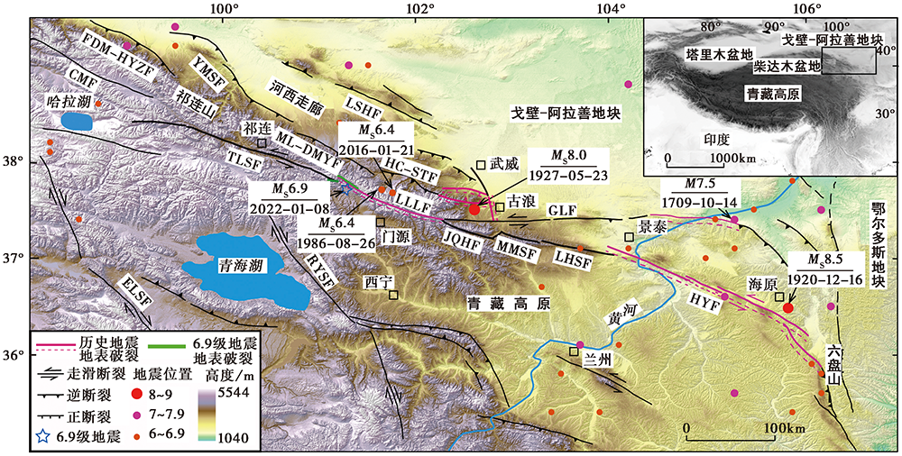
Fig. 1 Seismotectonic map of the Menyuan MS6.9 earthquake in Qinghai Province (modified from GUO Peng et al., 2017a).
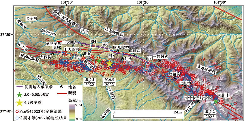
Fig. 2 Precise location results of the Menyuan MS6.9 earthquake sequence in 2022 (after Fan et al., 2022; XU Ying-cai et al., 2022), field survey sites and coseismic surface rupture zones.
| 序号 | 震中位置 | 震源 深度 /km | 节面Ⅰ | 节面Ⅱ | 震级 | 数据来源 | |||||
|---|---|---|---|---|---|---|---|---|---|---|---|
| 东经 | 北纬 | 走向 | 倾角 | 滑动角 | 走向 | 倾角 | 滑动角 | ||||
| 1 | 101.26° | 37.77° | 10 | MS6.9 | CENC① | ||||||
| 2 | 101.272 6° | 37.766 4° | 12.9 | MS6.9 | Fan et al., | ||||||
| 3 | 101.258° | 37.77° | 7.8 | 290° | 81° | 16° | 197° | 74° | 171° | MW6.6 | 许英才等, |
| 4 | 101.278° | 37.815° | 11.5 | 104° | 88° | 15° | 13° | 75° | 178° | MW6.6 | USGS② |
| 5 | 101.31° | 37.80° | 14.8 | 104° | 82° | 1° | 14° | 89° | 172° | MW6.7 | GCMT③ |
| 6 | 101.34° | 37.81° | 15 | 285° | 82° | 16° | 193° | 74° | 172° | MW6.6 | GFZ④ |
| 7 | 101.275° | 37.811° | 10 | MW6.6 | 中国地震局地球物理研究所⑤ | ||||||
| 8 | 210° | 72° | 177° | 301° | 87° | 18° | 中国地震局地球物理研究所⑥ | ||||
| 9 | 192° | 69° | 172° | 284° | 82° | 21° | MW6.7 | 中国地震局地球物理研究所⑤ | |||
Table 1 Source parameters of the 2022 Menyuan MS6.9 earthquake
| 序号 | 震中位置 | 震源 深度 /km | 节面Ⅰ | 节面Ⅱ | 震级 | 数据来源 | |||||
|---|---|---|---|---|---|---|---|---|---|---|---|
| 东经 | 北纬 | 走向 | 倾角 | 滑动角 | 走向 | 倾角 | 滑动角 | ||||
| 1 | 101.26° | 37.77° | 10 | MS6.9 | CENC① | ||||||
| 2 | 101.272 6° | 37.766 4° | 12.9 | MS6.9 | Fan et al., | ||||||
| 3 | 101.258° | 37.77° | 7.8 | 290° | 81° | 16° | 197° | 74° | 171° | MW6.6 | 许英才等, |
| 4 | 101.278° | 37.815° | 11.5 | 104° | 88° | 15° | 13° | 75° | 178° | MW6.6 | USGS② |
| 5 | 101.31° | 37.80° | 14.8 | 104° | 82° | 1° | 14° | 89° | 172° | MW6.7 | GCMT③ |
| 6 | 101.34° | 37.81° | 15 | 285° | 82° | 16° | 193° | 74° | 172° | MW6.6 | GFZ④ |
| 7 | 101.275° | 37.811° | 10 | MW6.6 | 中国地震局地球物理研究所⑤ | ||||||
| 8 | 210° | 72° | 177° | 301° | 87° | 18° | 中国地震局地球物理研究所⑥ | ||||
| 9 | 192° | 69° | 172° | 284° | 82° | 21° | MW6.7 | 中国地震局地球物理研究所⑤ | |||
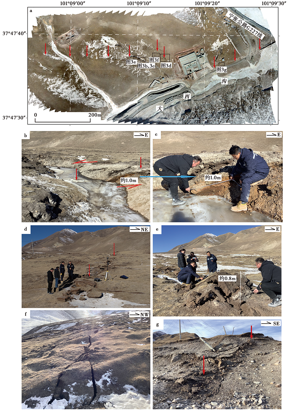
Fig. 3 Coseismic surface rupture along the Daxigou segment(see Fig. 2 for the location).
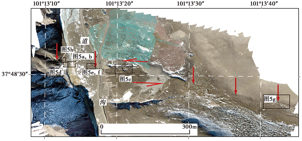
Fig. 4 Orthophotograph of the surface rupture zone of the Daogou segment and the inspection points(see Fig. 2b for the location).

Fig. 5 Coseismic surface rupture along the Daogou segment(see Fig. 4 for the location).
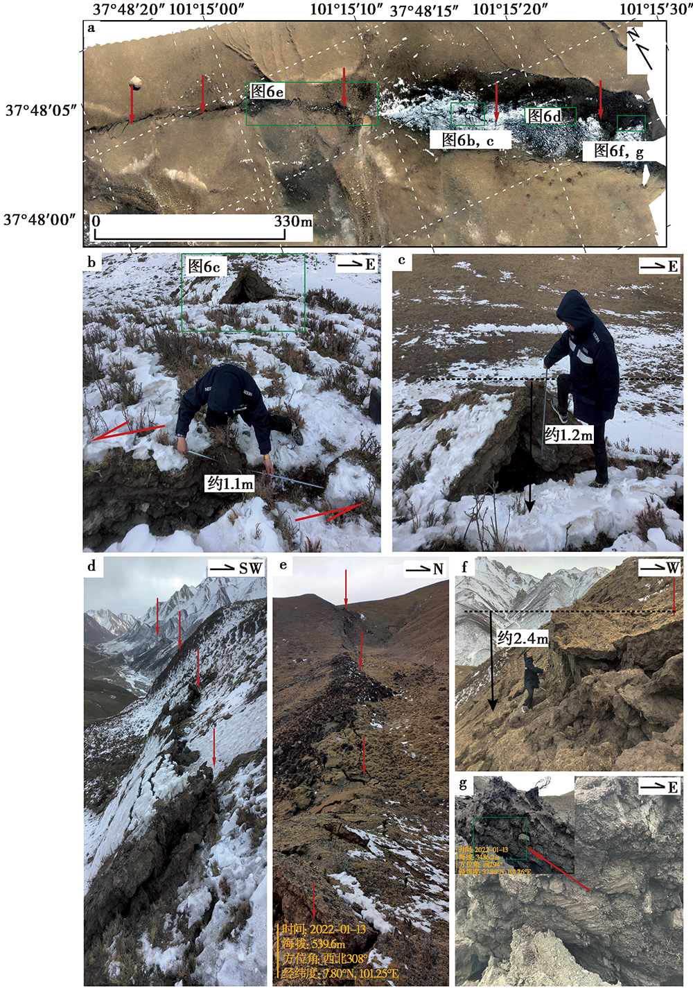
Fig. 6 Coseismic surface rupture in the western Liuhuanggou segment(see Fig. 2 for the location).
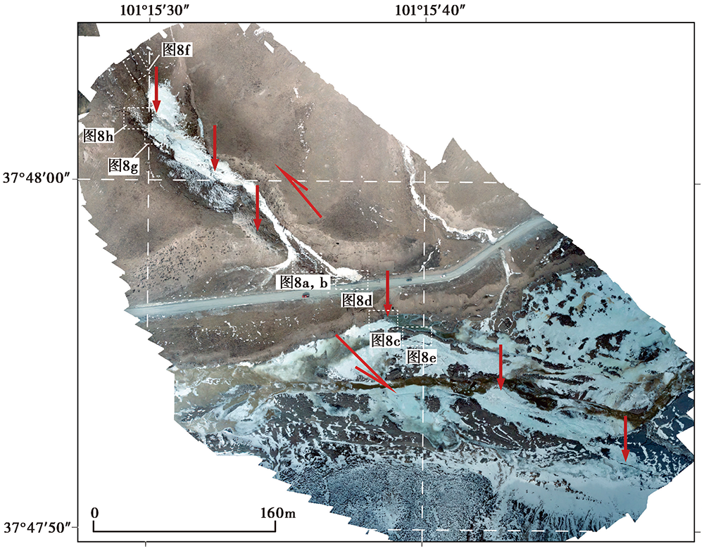
Fig. 7 Orthophotographic map of the surface rupture zone and investigation points of the Sushuanggou oblique cross-river segment(see Fig. 2 for the location).

Fig. 8 Coseismic surface rupture zone and investigation points of the Sushuanggou oblique cross-river segment(see Fig. 7 for the location).
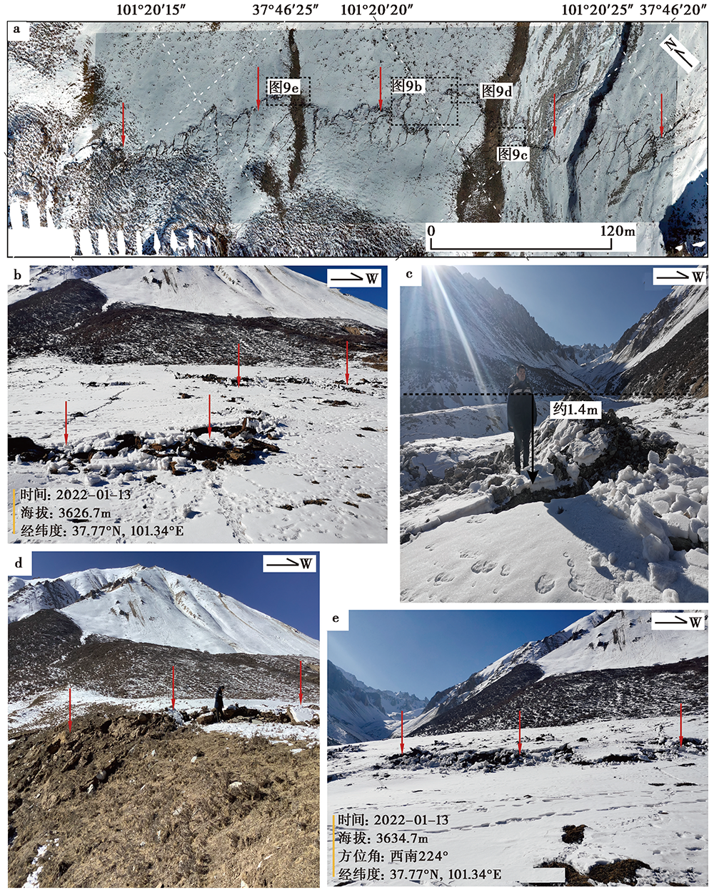
Fig. 9 Coseismic surface rupture in the eastern Liuhuanggou segment(see Fig. 2 for the location).
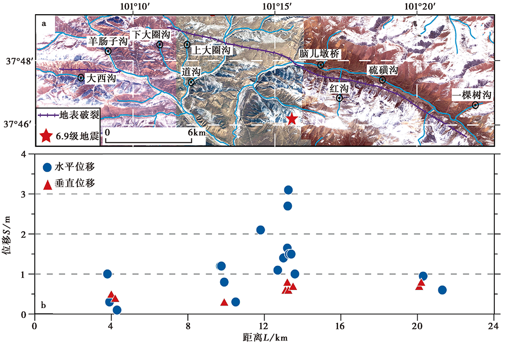
Fig. 10 Spatial distribution of earthquake surface rupture(a)and displacement(b).
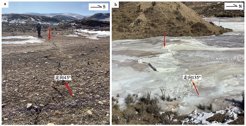
Fig. 11 Surface fissures and ice surface fissures developed in the Shangdaquangou.
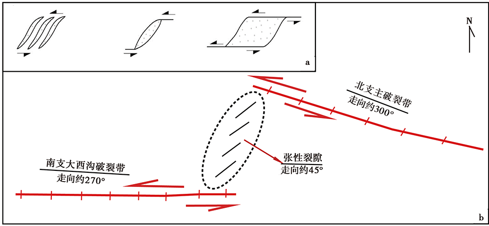
Fig. 12 The combined model of the surface rupture zone of the Menyuan MS6.9 earthquake.
| [1] |
艾晟, 张波, 樊春, 等. 2017. 武威盆地南缘断裂晚第四纪活动地表形迹与活动速率[J]. 地震地质, 39(2): 408-422. doi: 10.3969/j.issn.0253-4967.2017.02.010.
DOI |
| AI Sheng, ZHANG Bo, FAN Chun, et al. 2017. Surface cracks and slip rate of the fault along the southern margin of Wuwei Basin in the Late Quaternary[J]. Seismology and Geology, 39(2): 408-422. (in Chinese) | |
| [2] | 邓起东, 冉勇康, 杨晓平, 等. 2007. 中国活动构造图[CM]. 北京: 地震出版社. |
| DENG Qi-dong, RAN Yong-kang, YANG Xiao-ping, et al. 2007. Active Tectonic Map of China [CM]. Seismological Press, Beijing. (in Chinese) | |
| [3] | 邓起东, 张培震, 冉勇康, 等. 2002. 中国活动构造基本特征[J]. 中国科学(D辑), 32(12): 1020-1030, 1057. |
| DENG Qi-dong, ZHANG Pei-zhen, RAN Yong-kang, et al. 2002. Basic characteristics of active tectonics of China[J]. Science in China(Ser D), 32(12): 1020-1030, 1057. (in Chinese) | |
| [4] | 邓起东, 张培震, 冉勇康, 等. 2003. 中国活动构造与地震活动[J]. 地学前缘, 10(S1): 66-73. |
| DENG Qi-dong, ZHANG Pei-zhen, RAN Yong-kang, et al. 2003. Active tectonics and earthquake activities in China[J]. Earth Science Frontiers, 10(S1): 66-73. (in Chinese) | |
| [5] | 顾功叙, 林庭煌, 时振梁, 等. 1983. 中国地震目录(公元前1831年-公元1969年)[Z]. 北京: 科学出版社: 226-238, 255-258. |
| GU Gong-xu, LIN Ting-huang, SHI Zhen-liang, et al. 1983. Catalogue of Chinese Earthquakes(1831BC-1969AD)[Z]. Science Press, Beijing:226-238, 255-258. (in Chinese) | |
| [6] | 国家地震局地质研究所, 宁夏回族自治区地震局. 1990. 海原活动断裂带[M]. 北京: 地震出版社: 177-212. |
| Institute of Geology, State Seismological Bureau, Seismological Bureau of Ningxia Hui Autonomous Region. 1990. Haiyuan Active Fault System[M]. Seismological Press, Beijing: 177-212. (in Chinese) | |
| [7] | 国家地震局震害防御司. 1995. 中国历史强震目录(公元前23世纪-公元1911年)[Z]. 北京: 地震出版社: 1-514. |
| Department of Earthquake Disaster Prevention of State Seismological Bureau. 1995. The Catalogue of Historical Strong Earthquakes in China(23rd Century BC- 1911 AD)[Z]. Seismological Press, Beijing: 1-514. (in Chinese) | |
| [8] | 郭鹏, 韩竹军, 安艳芬, 等. 2017a. 冷龙岭断裂系活动性与2016年门源6.4级地震构造研究[J]. 中国科学(D辑), 47(5): 617-630. |
| GUO Peng, HAN Zhu-jun, AN Yan-fen, et al. 2017a. Activity of the Lenglongling fault system and seismotectonics of the 2016 MS6.4 Menyuan earthquake[J]. Science in China (Ser D), 47(5): 617-630. (in Chinese) | |
| [9] |
郭鹏, 韩竹军, 姜文亮, 等. 2017b. 青藏高原东北缘冷龙岭断裂全新世左旋滑动速率[J]. 地震地质, 39(2): 323-341. doi: 10.3969/j.issn.0253-4967.2017.02.005.
DOI |
| GUO Peng, HAN Zhu-jun, JIANG Wen-liang, et al. 2017b. Holocene left-lateral slip rate of the Lenglongling Fault, northeastern margin of the Tibetan plateau[J]. Seismology and Geology, 39(2): 323-341. (in Chinese) | |
| [10] | 刘金瑞, 任治坤, 张会平, 等. 2018. 海原断裂带老虎山段晚第四纪滑动速率精确厘定与讨论[J]. 地球物理学报, 61(4): 1281-1297. |
| LIU Jin-rui, REN Zhi-kun, ZHANG Hui-ping, et al. 2018. Late Quaternary slip rate of the Laohushan Fault within the Haiyuan fault zone and its tectonic implications[J]. Chinese Journal of Geophysics, 61(4): 1281-1297. (in Chinese) | |
| [11] |
李智敏, 苏鹏, 黄帅堂, 等. 2018. 日月山断裂德州段晚更新世以来的活动速率研究[J]. 地震地质, 40(3): 656-671. doi: 10.3969/j.issn.0253-4967.2018.03.011.
DOI |
| LI Zhi-min, SU Peng, HUANG Shuai-tang, et al. 2018. Slip rates of the Riyue Mt. Fault at Dezhou segment since late Pleistocene[J]. Seismology and Geology, 40(3): 656-671. (in Chinese) | |
| [12] | 徐纪人, 姚立珣, 汪进. 1986. 1986年8月26日门源6.4级地震及其强余震的震源机制解[J]. 西北地震学报, 8(4): 82-84. |
| XU Ji-ren, YAO Li-xun, WANG Jin. 1986. Focal mechanism solution of the Menyuan MS6.4 earthquake and its strong aftershocks on August 26, 1986[J]. Northwestern Seismological Journal, 8(4): 82-84. (in Chinese) | |
| [13] | 许英才, 郭祥云, 冯丽丽. 2022. 2022年1月8日青海门源 MS6.9 地震序列重定位和震源机制研究[J]. 地震学报, 44(2): 1-16. |
| XU Ying-cai, GUO Xiang-yun, FENG Li-li. 2022. Relocation and focal mechanism solutions of the MS6.9 Menyuan earthquake sequence on January 8, 2022 in Qinghai Province[J]. Acta Seismologica Sinica, 44(2): 1-16. (in Chinese) | |
| [14] | 袁道阳, 刘百篪, 吕太乙, 等. 1998. 北祁连山东段活动断裂带的分段性研究[J]. 西北地震学报, 20(4): 27-34. |
| YUAN Dao-yang, LIU Bai-chi, LÜ Tai-yi, et al. 1998. Study on the segmentation in east segment of the northern Qilianshan fault zone[J]. Northwestern Seismological Journal, 20(4): 27-34. (in Chinese) | |
| [15] | 袁道阳, 张培震, 刘小龙, 等. 2004. 青海鄂拉山断裂带晚第四纪构造活动及其所反映的青藏高原东北缘的变形机制[J]. 地学前缘, 11(4): 393-402. |
| YUAN Dao-yang, ZHANG Pei-zhen, LIU Xiao-long, et al. 2004. The tectonic activity and deformation features during the Late Quaternary of Elashan Mountain active fault zone in Qinghai Province and its implication for the deformation of the northeastern margins of the Qinghai-Tibet Plateau[J]. Earth Science Frontiers, 11(4): 393-402. (in Chinese) | |
| [16] | 张培震, 邓起东, 张国民, 等. 2003. 中国大陆的强震活动与活动地块[J]. 中国科学(D辑), 33(S1): 12-20. |
| ZHANG Pei-zhen, DENG Qi-dong, ZHANG Guo-min, et al. 2003. Active tectonic blocks and strong earthquakes in the continent of China[J]. Science in China(Ser D), 33(S1): 12-20. (in Chinese) | |
| [17] |
Fan L P, Li B R, Liao S R, et al. 2022. Precise earthquake sequence relocation of the Jan 08, Qinghai Menyuan MS6.9 earthquake[J]. Earthquake Science, 35(3)(in press). doi: 10.1016/j.eqs.2022.01.021.
DOI |
| [18] |
Gaudemer Y, Tapponnier P, Meyer B, et al. 1995. Partitioning of crustal slip between linked, active faults in the eastern Qilian Shan, and evidence for a major seismic gap, the ‘Tianzhu gap’ on the western Haiyuan Fault, Gansu(China)[J]. Geophysical Journal International, 120(3): 599-645.
DOI URL |
| [19] |
Guo P, Han Z J, Dong S P, et al. 2019a. Surface rupture and slip distribution along the Lenglongling Fault in the NE Tibetan plateau: Implications for faulting behavior[J]. Journal of Asian Earth Sciences, 172:190-207.
DOI URL |
| [20] |
Guo P, Han Z J, Mao Z B, et al. 2019b. Paleoearthquakes and rupture behavior of the Lenglongling Fault: Implications for seismic hazards of the northeastern margin of the Tibetan plateau[J]. Journal of Geophysical Research: Solid Earth, 124(2): 1520-1543.
DOI URL |
| [21] | Koide H, Bhattacharji S. 1977. Geometric patterns of active strike-slip faults and their significance as indicators for areas of energy release//Saxena S K, Bhattacharji S(eds). Energetics of Geological Processes[M]. Springer Verlag, New York: 3465-3478. |
| [22] | Molnar P, Stock J M. 2009. Slowing of India’s convergence with Eurasia since 20Ma and its implications for Tibetan mantle dynamics[J]. Tectonics, 28(3): 1-11. |
| [23] |
Peltzer G, Tapponnier P, Gaudemer Y, et al. 1988. Offsets of Late Quaternary morphology, rate of slip, and recurrence of large earthquakes on the Chang Ma Fault(Gansu, China)[J]. Journal of Geophysical Research, 93(B7): 7793-7812.
DOI URL |
| [24] |
Tapponnier P, Molnar P. 1977. Active faulting and tectonics in China[J]. Journal of Geophysical Research, 82(20): 2905-2930.
DOI URL |
| [25] |
Xu X W, Yeats R S, Yu G H. 2010. Five short historical earthquake surface ruptures near the Silk Road, Gansu Province, China[J]. Bulletin of the Seismological Society of America, 100(2): 541-561.
DOI URL |
| [26] |
Zhang P Z, Shen Z K, Wang M, et al. 2004. Continuous deformation of the Tibetan plateau from global positioning system data[J]. Geology, 32(9): 809-812.
DOI URL |
| [27] | Zhang W Q, Jiao D C, Zhang P Z, et al. 1987. Displacement along the Haiyuan Fault associated with the great 1920 Haiyuan, China, earthquake[J]. Bulletin of the Seismological Society of America, 77(1): 117-131. |
| [28] |
Zheng W J, Zhang P Z, He W G, et al. 2013. Transformation of displacement between strike-slip and crustal shortening in the northern margin of the Tibetan plateau: Evidence from decadal GPS measurements and late Quaternary slip rates on faults[J]. Tectonophysics, 584:267-280.
DOI URL |
| [1] | GAO Shu-de, WU Xiao-ping, LUO Wei-bin, YANG Xiao-peng, WANG Wen-cai, YAO Sai-sai, CHEN Shuang-gui, LIU Jun. SUMMARY OF PRECURSORS OF THE MENYUAN MS6.9 EARTHQUAKE AND ITS INSPIRATION FOR SUB-INSTABILITY THEORY [J]. SEISMOLOGY AND GEOLOGY, 2025, 47(6): 1546-1565. |
| [2] | QIAO Jun-xiang, SHI Feng, LI An, LI Tao, ZHANG Da, WANG Xin, Gesangdanzhen, SUN Hao-yue. COSEISMIC SURFACE RUPTURE OF THE MS6.8 DINGRI EARTHQUAKE IN XIZANG, CHINA, BASED ON GF IMAGERY INTERPRETATION [J]. SEISMOLOGY AND GEOLOGY, 2025, 47(3): 789-805. |
| [3] | SHI Feng, LIANG Ming-jian, LUO Quan-xing, QIAO Jun-xiang, ZHANG Da, WANG Xin, YI Wen-xing, ZHANG Jia-wei, ZHANG Ying-feng, ZHANG Hui-ping, LI Tao, LI An. SEISMOGENIC FAULT AND COSEISMIC SURFACE DEFORMATION OF THE DINGRI MS6.8 EARTHQUAKE IN XIZANG, CHINA [J]. SEISMOLOGY AND GEOLOGY, 2025, 47(1): 1-15. |
| [4] | NIU Peng-fei, HAN Zhu-jun, GUO Peng, LIU Guan-shen, LUO Jia-hong, GUO Zhao-wu. THE COULOMB STRESS TRIGGERING EFFECT OF 2016 MW5.9 AND 2022 MW6.7 EARTHQUAKES IN MENYUAN, QINGHAI AND THEIR INFLUENCE ON THE SURROUNDING SEISMOGENIC FAULTS [J]. SEISMOLOGY AND GEOLOGY, 2025, 47(1): 325-344. |
| [5] | NIU Peng-fei, HAN Zhu-jun, GUO Peng, LI Ke-chang, LÜ Li-xing. THE DISASTER MECHANISM OF THE MS6.9 EARTHQUAKE IN MENYUAN, QINGHAI PROVINCE, 2022 [J]. SEISMOLOGY AND GEOLOGY, 2024, 46(4): 761-782. |
| [6] | ZHANG Bo-xuan, QIAN Li, LI Tao, CHEN Jie, XU Jian-hong, YAO Yuan, FANG Li-hua, XIE Chao, CHEN Jian-bo, LIU Guan-shen, HU Zong-kai, YANG Wen-xin, ZHANG Jun-long, PANG Wei. GEOLOGICAL DISASTERS AND SURFACE RUPTURES OF JANUARY 23, 2024 MS7.1 WUSHI EARTHQUAKE, XINJIANG, CHINA [J]. SEISMOLOGY AND GEOLOGY, 2024, 46(1): 220-234. |
| [7] | LI Yuan, YANG Zhou-sheng, PANG Ya-jin, LIANG Hong-bao, LIU Xia. NUMERICAL SIMULATION OF FAULT ACTIVITY AND STRESS STATE BEFORE MS6.9 MENYUAN EARTHQUAKE [J]. SEISMOLOGY AND GEOLOGY, 2023, 45(6): 1286-1308. |
| [8] | YOU Zi-cheng, BI Hai-yun, ZHENG Wen-jun, PENG Hui, LIANG Shu-min, DUAN Lei, QIN Yi-gen. FINE CHARACTERISTICS OF EARTHQUAKE SURFACE RUPTURE ZONE BASED ON HIGH-RESOLUTION REMOTE SENSING IMAGE: A CASE STUDY OF LITANG FAULT [J]. SEISMOLOGY AND GEOLOGY, 2023, 45(5): 1057-1073. |
| [9] | ZUO Yu-qi, YANG Hai-bo, YANG Xiao-ping, ZHAN Yan, LI An, SUN Xiang-yu, HU Zong-kai. EVIDENCE OF LATE QUATERNARY TECTONIC ACTIVITY OF THE BEIDA SHAN FAULT, SOUTHERN MARGIN OF THE ALASHAN BLOCK [J]. SEISMOLOGY AND GEOLOGY, 2023, 45(2): 355-376. |
| [10] | WANG Liao, XIE Hong, YUAN Dao-yang, LI Zhi-min, XUE Shan-yu, SU Rui-huan, WEN Ya-meng, SU Qi. THE SURFACE RUPTURE CHARACTERISTICS BASED ON THE GF-7 IMAGES INTERPRETATION AND THE FIELD INVESTIGA-TION OF THE 2022 MENYUAN MS6.9 EARTHQUAKE [J]. SEISMOLOGY AND GEOLOGY, 2023, 45(2): 401-421. |
| [11] | YU Shu-yuan, HUANG Xian-liang, ZHENG Hai-gang, LI Ling-li, LUO Jia-ji, DING Juan, FAN Xiao-ran. THE COSEISMIC RUPTURE MODEL AND STRESS CHANGE OF THE 2022 MENYUAN MW6.7 EARTHQUAKE [J]. SEISMOLOGY AND GEOLOGY, 2023, 45(1): 286-303. |
| [12] | LI Chuan-you, SUN Kai, MA Jun, LI Jun-jie, LIANG Ming-jian, FANG Li-hua. THE 2022 M6.8 LUDING EARTHQUAKE: A COMPLICATED EVENT BY FAULTING OF THE MOXI SEGMENT OF THE XIANSHUIHE FAULT ZONE [J]. SEISMOLOGY AND GEOLOGY, 2022, 44(6): 1648-1666. |
| [13] | LIU Xiao-li, XIA Tao, LIU-ZENG Jing, YAO Wen-qian, XU Jing, DENG De-bei-er, HAN Long-fei, JIA Zhi-ge, SHAO Yan-xiu, WANG Yan, YUE Zi-yang, GAO Tian-qi. DISTRIBUTED CHARACTERISTICS OF THE SURFACE DEFORMATIONS ASSOCIATED WITH THE 2021 MW7.4 MADOI EARTHQUAKE, QINGHAI, CHINA [J]. SEISMOLOGY AND GEOLOGY, 2022, 44(2): 461-483. |
| [14] | YAO Wen-qian, WANG Zi-jun, LIU-ZENG Jing, LIU Xiao-li, HAN Long-fei, SHAO Yan-xiu, WANG Wen-xin, XU Jing, QIN Ke-xin, GAO Yun-peng, WANG Yan, LI Jin-yang, ZENG Xian-yang. DISCUSSION ON COSEISMIC SURFACE RUPTURE LENGTH OF THE 2021 MW7.4 MADOI EARTHQUAKE, QINGHAI, CHINA [J]. SEISMOLOGY AND GEOLOGY, 2022, 44(2): 541-559. |
| [15] | LIANG Kuan, HE Zhong-tai, JIANG Wen-liang, LI Yong-sheng, LIU Ze-min. SURFACE RUPTURE CHARACTERISTICS OF THE MENYUAN MS6.9 EARTHQUAKE ON JANUARY 8, 2022, QINGHAI PROVINCE [J]. SEISMOLOGY AND GEOLOGY, 2022, 44(1): 256-278. |
| Viewed | ||||||
|
Full text |
|
|||||
|
Abstract |
|
|||||
Copyright © SEISMOLOGY AND GEOLOGY, All Rights Reserved.
Tel: 010-62009049/9063 E-mail: dzdz@ies.ac.cn
Powered by Beijing Magtech Co., Ltd.