
SEISMOLOGY AND GEOLOGY ›› 2025, Vol. 47 ›› Issue (3): 789-805.DOI: 10.3969/j.issn.0253-4967.2025.03.20250043
Previous Articles Next Articles
COSEISMIC SURFACE RUPTURE OF THE MS6.8 DINGRI EARTHQUAKE IN XIZANG, CHINA, BASED ON GF IMAGERY INTERPRETATION
QIAO Jun-xiang1,2)( ), SHI Feng1,2), LI An1,2), LI Tao1,3), ZHANG Da1,2), WANG Xin1,2), Gesangdanzhen4), SUN Hao-yue1,2),*()
- 1)State Key Laboratory of Earthquake Dynamies and Forecasting, Institute of Geology, China Earhquake Administration, Beijing 100029, China
2)Shanxi Taiyuan Continental Rif Dynamics Nation Observation and Research Station, Beijing 100029, China
3)Xingjiang Pamir intracontinental Subduction National Observation and Research Station, Beijing 100029, China
4)Earthquake Administration of Tibet Autonomous Region, Lhasa 850000, China
-
Received:2025-01-27Revised:2025-03-19Online:2025-06-20Published:2025-08-13
高分影像在2025年1月7日西藏定日MS6.8地震同震地表破裂调查中的应用
乔俊香1,2)(), 石峰1,2), 李安1,2), 李涛1,3), 张达1,2), 王鑫1,2), 格桑旦珍4), 孙浩越1,2),*()
- 1)中国地震局地质研究所, 地震动力学与强震预测全国重点实验室(中国地震局地质研究所), 北京 100029
2)山西太原大陆裂谷动力学国家野外科学观测研究站, 北京 100029
3)新疆帕米尔陆内俯冲国家野外科学观测研究站, 北京 100029
4)西藏自治区地震局 拉萨, 850000
-
通讯作者:*孙浩越, 男, 1986年生, 博士, 副研究员, 主要研究方向为活动构造, Email: sunhaoyue@ies.ac.cn。 -
作者简介:乔俊香, 女, 2001年生, 2023年于西南科技大学获地质工程专业学士学位, 现为中国地震局地质研究所构造地质学专业在读硕士研究生, 主要研究方向为活动构造, E-mail: xeniaqjx@163.com。
-
基金资助:中国地震局地质研究所基本科研业务专项(IGCEA1801); 中国地震局地质研究所基本科研业务专项(IGCEA2502); 地震动力学国家重点实验室自主课题(LED2021A02)
Cite this article
QIAO Jun-xiang, SHI Feng, LI An, LI Tao, ZHANG Da, WANG Xin, Gesangdanzhen, SUN Hao-yue. COSEISMIC SURFACE RUPTURE OF THE MS6.8 DINGRI EARTHQUAKE IN XIZANG, CHINA, BASED ON GF IMAGERY INTERPRETATION[J]. SEISMOLOGY AND GEOLOGY, 2025, 47(3): 789-805.
乔俊香, 石峰, 李安, 李涛, 张达, 王鑫, 格桑旦珍, 孙浩越. 高分影像在2025年1月7日西藏定日MS6.8地震同震地表破裂调查中的应用[J]. 地震地质, 2025, 47(3): 789-805.
share this article
Add to citation manager EndNote|Ris|BibTeX
URL: https://www.dzdz.ac.cn/EN/10.3969/j.issn.0253-4967.2025.03.20250043
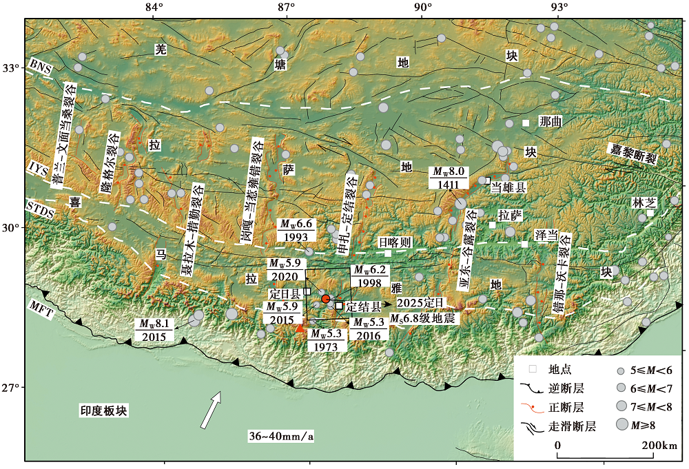
Fig. 1 Tectonic background of the 2025 MS6.8 Dingri Earthquake.
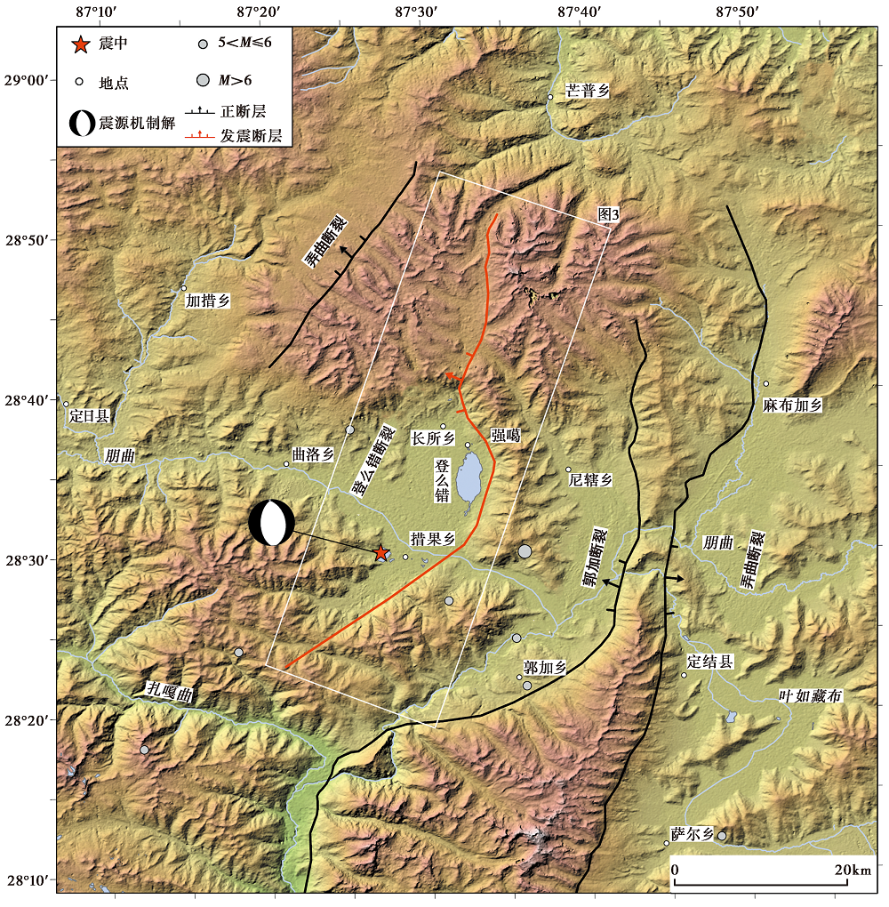
Fig. 2 Regional tectonic setting map.
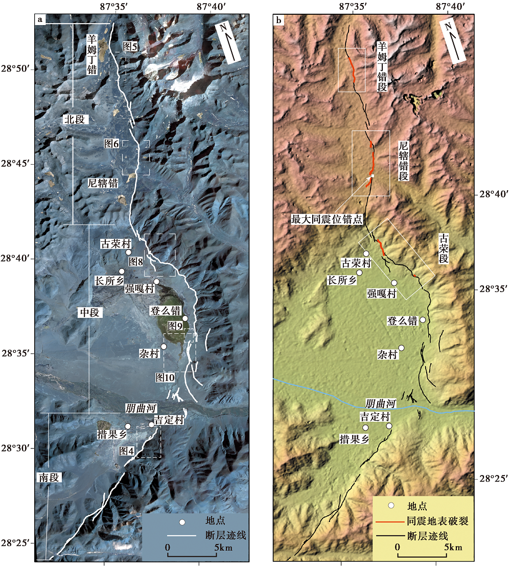
Fig. 3 Seismogenic fault and surface rupture zone distribution map.
Fig. 4 Fault-displaced landforms along the southern segment of the Dengmecuo Fault.
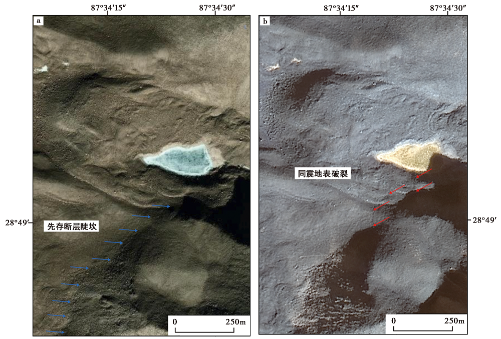
Fig. 5 Comparison of pre-earthquake and post-earthquake surface rupture zones in the Yangmudingcuo fault segment.
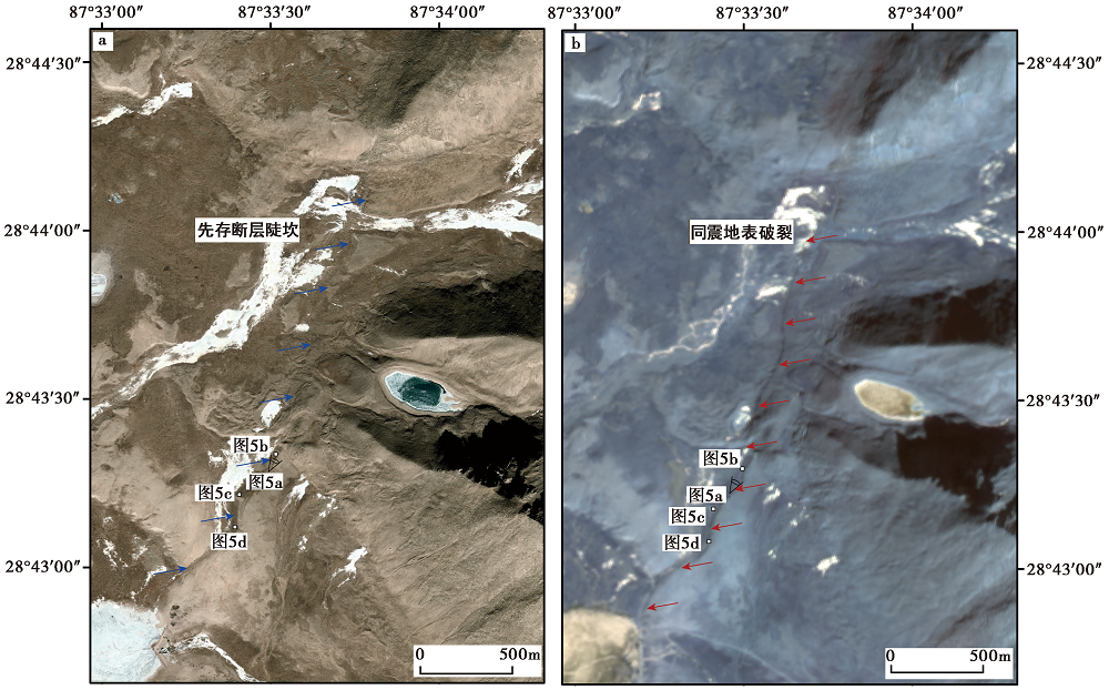
Fig. 6 Comparison of pre-earthquake and post-earthquake coseismic surface rupture in the Nixiacuo segment.
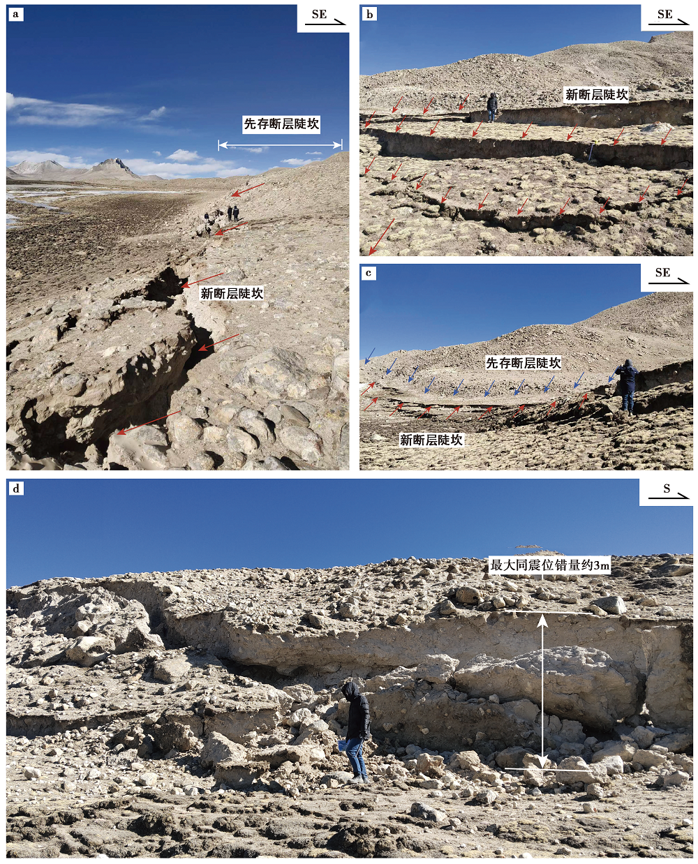
Fig. 7 Three styles of fault scarps and maximum coseismic displacement points in the Nixiacuo segment.
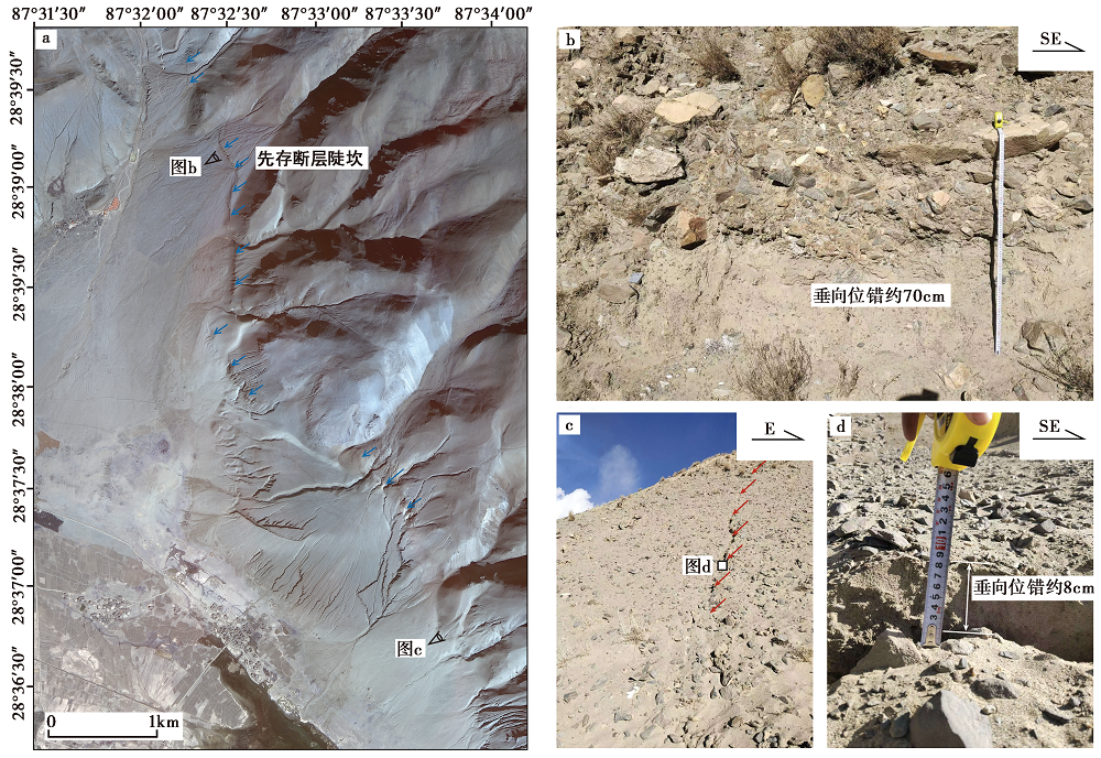
Fig. 8 Surface rupture process of Gurong segment.
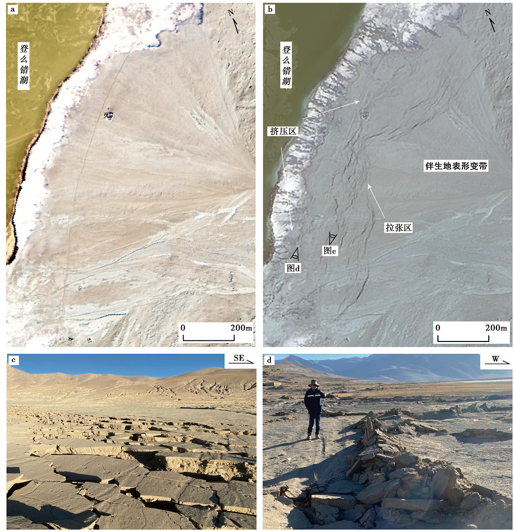
Fig. 9 Surface deformation zone accompanying the middle segment of the Dengmecuo Fault.
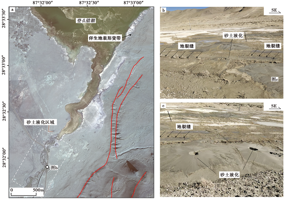
Fig. 10 Liquefaction-induced geomorphic features along the southern margin of Dengmecuo Lake.
| [1] |
才巴央增, 赵俊猛. 2018. 藏南裂谷系的研究综述[J]. 地震研究, 41(1): 14-21.
|
|
|
|
| [2] |
国家地震局震害防御司. 1995. 中国历史强震目录: 公元前23世纪-公元1911年[M]. 北京: 地震出版社.
|
|
Department of Earthquake Disaster Mitigation, China Earthquake Administration. 1995. Catalogue of Historical Strong Earthquakes in China: 23rd Century BC-AD 1911[M]. Seismological Press, Beijing (in Chinese).
|
|
| [3] |
黄铁青, 赵涛, 翟金良, 等. 2008. 发挥空间信息技术优势, 服务汶川抗震救灾决策——中国科学院利用遥感与地理信息技术为汶川地震抗震救灾和恢复重建提供决策服务纪略[J]. 遥感技术与应用, 23(4): 486-492.
|
|
|
|
| [4] |
李德仁, 陈晓玲, 蔡晓斌. 2008. 空间信息技术用于汶川地震救灾[J]. 遥感学报, 12(6): 841-851.
|
|
|
|
| [5] |
石峰, 何宏林, 张英. 2010. 青海玉树 MS7.1 地震地表破裂带的遥感影像解译[J]. 震灾防御技术, 5(2): 220-227.
|
|
|
|
| [6] |
石峰, 梁明剑, 罗全星, 等. 2025. 2025年1月7日西藏定日6.8级地震发震构造与同震地表破裂特征[J]. 地震地质, 47(1): 1-15. doi: 10.3969/j.issn.0253-4967.2025.01.001.
|
|
DOI |
|
| [7] |
田婷婷. 2021. 申扎-定结裂谷南段丁木错断裂晚第四纪古地震事件研究[D]. 北京: 中国地质大学(北京).
|
|
|
|
| [8] |
田婷婷, 吴中海. 2023. 西藏申扎-定结裂谷南段丁木错正断层的最新史前大地震事件及其地震地质意义[J]. 地质论评, 69(1): 53-55.
|
|
|
|
| [9] |
魏永明, 李剑南, 陈玉, 等. 2021. 不同类型发震断层的同震地表破裂光学遥感特征研究[J]. 第四纪研究, 41(6): 1513-1531.
|
|
|
|
| [10] |
吴章明. 1992. 西藏高原震中分布与活动断层[J]. 地震研究, 15(2): 210-218.
|
|
|
|
| [11] |
吴中海, 张永双, 胡道功, 等. 2007. 西藏桑日县沃卡地堑的第四纪正断层活动及其机制探讨[J]. 地质学报, 81(10): 1328-1339.
|
|
|
|
| [12] |
徐心悦. 2019. 藏南申扎-定结断裂系卡达正断裂晚第四纪活动性及其环境效应[D]. 北京: 中国地震局地质研究所.
|
|
|
|
| [13] |
徐岳仁, 陈立泽, 申旭辉, 等. 2015. 基于GF-1卫星影像解译2014年新疆于田 MS7.3 地震同震地表破裂带[J]. 地震, 5(2): 61-71.
|
|
|
|
| [14] |
袁兆德, 刘静, 李雪, 等. 2021. 2014年新疆于田 MS7.3 地震地表破裂带精细填图及其破裂特征[J]. 中国科学(D辑), 51(2): 276-298.
|
|
|
|
| [15] |
中国地震局震害防御司. 1999. 中国近代地震目录公元1912-1990年, MS≥4.7[M]. 北京: 中国科学技术出版社.
|
|
Department of Earthquake Disaster Mitigation, China Earthquake Administration. 1999. Catalogue of Modern Earthquakes in China: AD 1912-1990, MS≥4.7[M]. China Science and Technology Press, Beijing (in Chinese).
|
|
| [16] |
|
| [17] |
|
| [18] |
|
| [19] |
PMID |
| [20] |
|
| [1] | DU Hao-guo, ZUO Xiao-qing, LIN Xu-chuan, XIAO Ben-fu, LU Yong-kun, HE Shi-fang, ZHANG Fang-hao, YUAN Xiao-xiang, TAO Tian-yan, YE Yang, DENG Shu-rong, ZHAO Zheng-xian, XU Jun-zu, BAI Xian-fu, ZHANG Yuan-shuo, ZHANG Lu-lu. TEXTURE FEATURE DAMAGE DETECTION OF SINGLE BUILD-ING BASED ON DRONE IMAGES AFTER EARTHQUAKE: A CASE STUDY OF 2025 DINGRI MS6.8 EARTHQUAKE IN XIZANG, CHINA [J]. SEISMOLOGY AND GEOLOGY, 2025, 47(3): 949-968. |
| [2] | JI Zhi-wei, YU Hou-yun, LI Zong-chao, JU Chang-hui, SUN Yao-chong, ZHANG Yong-xian, CHEN Xiao-fei. PRELIMINARY SIMULATION OF LONG-PERIOD GROUND MOTION OF THE DINGRI MS6.8 EARTHQUAKE ON JANUARY 7, 2025 [J]. SEISMOLOGY AND GEOLOGY, 2025, 47(3): 917-931. |
| [3] | YIN Xiao-fei, QIANG Sheng-yin, ZHANG Wei, SHAO Zhi-gang, WANG Wu-xing, YUAN Xiao-xiang, LI Yong-sheng, LIU Hao. RESEARCH ON GROUND MOTION SIMULATION OF THE DINGRI MS6.8 EARTHQUAKE IN XIZANG BASED ON DIFFERENT SOURCE MODELS [J]. SEISMOLOGY AND GEOLOGY, 2025, 47(3): 897-916. |
| [4] | WU Xiao-fei, MENG Ling-yuan. COMPARISON OF THE CHARACTERISTICS OF EARTHQUAKE SEQUENCE AND INTENSITY OF THE JANUARY 7, 2025 MS6.8 DINGRI EARTHQUAKE IN XIZANG [J]. SEISMOLOGY AND GEOLOGY, 2025, 47(3): 869-880. |
| [5] | XU Yue-yi, XU Bei-bei, XU Chen-yu, SHAO Zhi-gang, HU Chao-zhong. JOINT INVERSION OF THE 2025 DINGRI MS6.8 EARTHQUAKE RUPTURE PROCESS BASED ON TELESEISMIC P WAVES, STRONG-MOTION AND INSAR DATA [J]. SEISMOLOGY AND GEOLOGY, 2025, 47(3): 734-746. |
| [6] | WANG Duo, CHEN Li-chun, LI Yan-bao, WANG Hu, JIA Yong-shun, GAO Yin-yi, XUE Ke-yi. LATE QUATERNARY ACTIVITY OF THE XIETONGMEN TO DENGMECUO SEGMENT ALONG THE XAINZA-DINGGYE RIFT IN SOUTHERN QINGHAI-XIZANG PLATEAU [J]. SEISMOLOGY AND GEOLOGY, 2025, 47(3): 718-733. |
| [7] | GAO Yang, WU Zhong-hai, HAN Shuai, TIAN Ting-ting. LATE QUATERNARY THROW RATE OF THE SEISMOGENIC FAULT(DENGMECUO FAULT)OF THE 2025 MS6.8 DINGRI EARTHQUAKE IN SHIGATSE [J]. SEISMOLOGY AND GEOLOGY, 2025, 47(3): 689-706. |
| [8] | GUO Zhao-wu, LU Ren-qi, ZHANG Jin-yu, FANG Li-hua, LIU Guan-shen, WU Xi-yan, SUN Xiao, QI Shi-miao. THREE-DIMENSIONAL MODEL OF SEISMOGENIC FAULT AND SEISMIC ENVIRONMENT OF XIZANG DINGRI MS6.8 EARTHQUAKE OF JANUARY 7, 2025 [J]. SEISMOLOGY AND GEOLOGY, 2025, 47(3): 671-688. |
| [9] | ZHANG Li-feng, ZHONG Mei-jiao, PAN Yu-hang, GUO Ying-xia, SUN Xi-hao, ZHANG Yuan-sheng. STUDY ON THERMAL INFRARED ANOMALIES OF THE 2025 DINGRI MS6.8 EARTHQUAKE AND SEVERAL EARTHQUAKE CASES IN SOUTHERN XIZANG [J]. SEISMOLOGY AND GEOLOGY, 2025, 47(3): 984-998. |
| [10] | LIANG Ming-jian, DONG Yun-xi, ZUO Hong, DAI You-lin, XIAO Ben-fu, LIAO Cheng, TAN Ling, WANG Yu-wei, LI Xiang, TANG Cai-cheng, ZHANG Wei, ZHANG Hui-ping, MENG Ling-yuan, SU Jin-rong, WU Wei-wei, LI Chuan-you, YAN Mei. SURFACE DEFORMATION CHARACTERISTICS AND CAUSES OF THE DENGMECUO SEGMENT IN THE XIZANG DINGRI MS6.8 EARTHQUAKE [J]. SEISMOLOGY AND GEOLOGY, 2025, 47(1): 80-89. |
| [11] | WEI Ben-yong, ZHANG Yu-man, SHI Feng, QIAO Jun-xiang, WANG Xin, ZHANG Da. ANALYSIS OF BUILDING DAMAGE AND CASUALTIES OF THE 2025 DINGRI MS6.8 EARTHQUAKE IN XIZANG BASED ON FIELD INVESTIGATION [J]. SEISMOLOGY AND GEOLOGY, 2025, 47(1): 64-79. |
| [12] | YANG Jian-wen, JIN Ming-pei, YE Beng, LI Zhen-ling, LI Qing. SOURCE RUPTURE MECHANISM AND STRESS CHANGES TO THE ADJACENT AREA OF JANUARY 7, 2025, MS6.8 DINGRI EARTHQUAKE, XIZANG, CHINA [J]. SEISMOLOGY AND GEOLOGY, 2025, 47(1): 36-48. |
| [13] | ZOU Jun-jie, SHAO Zhi-gang, HE Hong-lin, GAO Lu, XU Yue-yi, DOU Ai-xia, LIANG Ze-yu. SURFACE RUPTURE INTERPRETATION AND BUILDING DAMAGE ASSESSMENT OF XIZANG DINGRI MS6.8 EARTHQUAKE ON JANUARY 7, 2025 [J]. SEISMOLOGY AND GEOLOGY, 2025, 47(1): 16-35. |
| [14] | SHI Feng, LIANG Ming-jian, LUO Quan-xing, QIAO Jun-xiang, ZHANG Da, WANG Xin, YI Wen-xing, ZHANG Jia-wei, ZHANG Ying-feng, ZHANG Hui-ping, LI Tao, LI An. SEISMOGENIC FAULT AND COSEISMIC SURFACE DEFORMATION OF THE DINGRI MS6.8 EARTHQUAKE IN XIZANG, CHINA [J]. SEISMOLOGY AND GEOLOGY, 2025, 47(1): 1-15. |
| [15] | LI Hao-feng, XU Yue-ren, GUO Ya-li, LIU Han, ZHAO Xin-yu, LU Ling-yu, TANG Jia-cheng. REMOTE SENSING INTEPRETATION OF COSEISMIC LAND-SLIDES TRIGGERED BY 1976 LONGLING MS7.3 AND MS7.4 EARTHQUAKES AND THE TECTONIC SIGNIFICANCES [J]. SEISMOLOGY AND GEOLOGY, 2024, 46(1): 117-140. |
| Viewed | ||||||
|
Full text |
|
|||||
|
Abstract |
|
|||||
Copyright © SEISMOLOGY AND GEOLOGY, All Rights Reserved.
Tel: 010-62009049/9063 E-mail: dzdz@ies.ac.cn
Powered by Beijing Magtech Co., Ltd.