
SEISMOLOGY AND GEOLOGY ›› 2025, Vol. 47 ›› Issue (3): 984-998.DOI: 10.3969/j.issn.0253-4967.2025.03.20250010
STUDY ON THERMAL INFRARED ANOMALIES OF THE 2025 DINGRI MS6.8 EARTHQUAKE AND SEVERAL EARTHQUAKE CASES IN SOUTHERN XIZANG
ZHANG Li-feng1,2)( ), ZHONG Mei-jiao3),*(), PAN Yu-hang4), GUO Ying-xia1,2), SUN Xi-hao1,2), ZHANG Yuan-sheng3)
- 1)Golmud Geodynamics Field Observation and Research Station of Qinghai-Tibet Plateau, Xining 810005, China
2)Qinghai Earthquake Agency, Xining 810005, China
3)Gansu Lanzhou Geophysics National Observation and Research Station, Lanzhou 730000, China
4)Tianjin Earthquake Agency, Tianjin 300201, China
-
Received:2025-01-21Revised:2025-03-25Online:2025-06-20Published:2025-08-13
2025年定日 MS6.8 地震及西藏南部几次震例热红外异常
张丽峰1,2)(), 钟美娇3),*(), 潘宇航4), 郭瑛霞1,2), 孙玺皓1,2), 张元生3)
- 1)青海格尔木青藏高原内部地球动力学野外科学观测研究站, 西宁 810005
2)青海省地震局, 西宁 810005
3)甘肃兰州地球物理国家野外科学观测研究站, 兰州 730000
4)天津市地震局, 天津 300201
-
通讯作者:*钟美娇, 女, 1981年生, 博士, 高级工程师, 从事遥感应用与地震预报研究, E-mail: 120238662@qq.com。 -
作者简介:张丽峰, 女, 1989年生, 2016年于中国地震局兰州地震研究所获固体地球物理学专业硕士学位, 工程师, 主要从事地震热红外及地震活动性研究, E-mail: ZhangLFng@163.com。
-
基金资助:青海格尔木青藏高原内部地球动力学野外科学观测研究站专项(202101); 青海格尔木青藏高原内部地球动力学野外科学观测研究站专项(202401); 甘肃省自然科学基金(23JRRA1566); 青海省地震科学基金(2023A02)
Cite this article
ZHANG Li-feng, ZHONG Mei-jiao, PAN Yu-hang, GUO Ying-xia, SUN Xi-hao, ZHANG Yuan-sheng. STUDY ON THERMAL INFRARED ANOMALIES OF THE 2025 DINGRI MS6.8 EARTHQUAKE AND SEVERAL EARTHQUAKE CASES IN SOUTHERN XIZANG[J]. SEISMOLOGY AND GEOLOGY, 2025, 47(3): 984-998.
张丽峰, 钟美娇, 潘宇航, 郭瑛霞, 孙玺皓, 张元生. 2025年定日 MS6.8 地震及西藏南部几次震例热红外异常[J]. 地震地质, 2025, 47(3): 984-998.
share this article
Add to citation manager EndNote|Ris|BibTeX
URL: https://www.dzdz.ac.cn/EN/10.3969/j.issn.0253-4967.2025.03.20250010
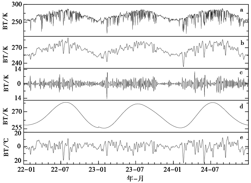
Fig. 1 Wavelet decomposition and signal separation.
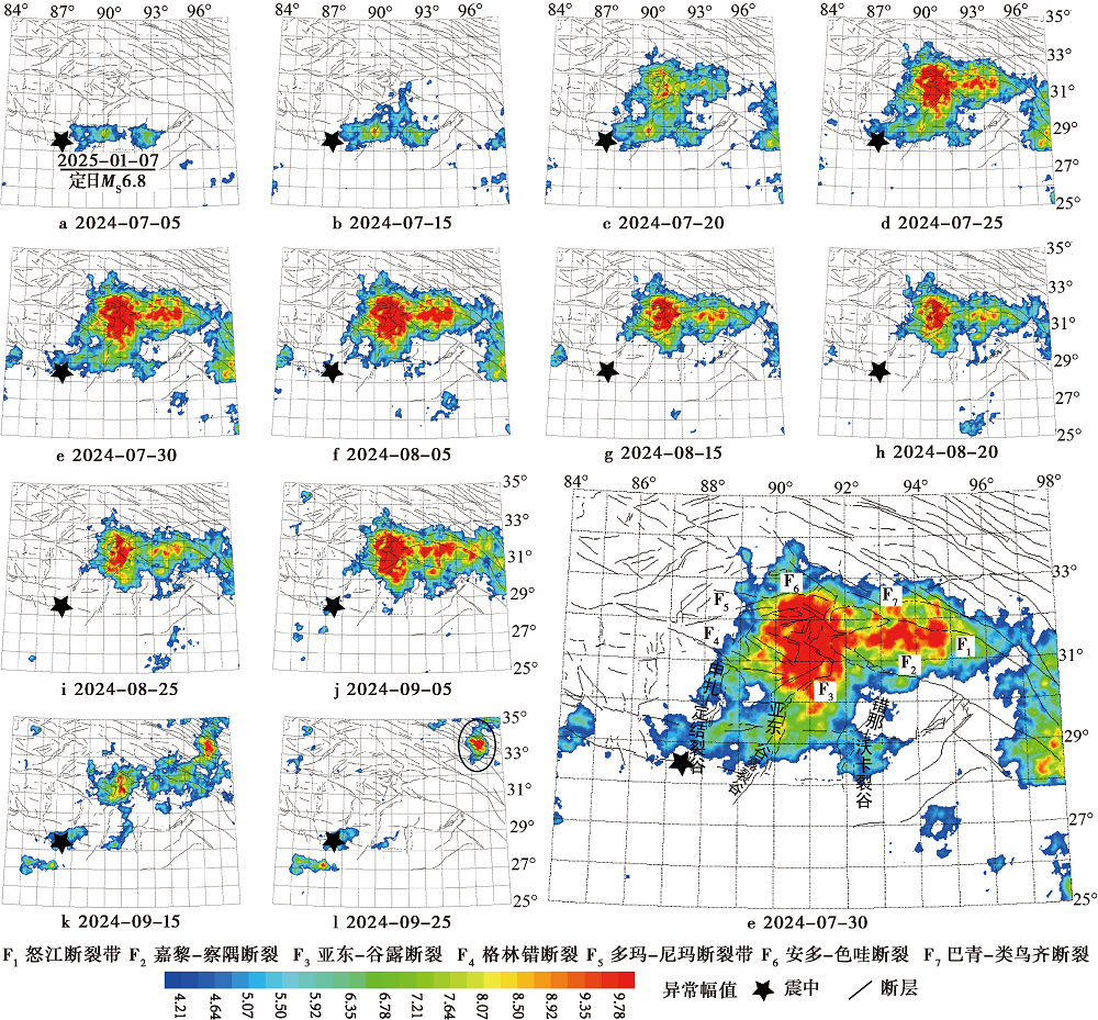
Fig. 2 Thermal infrared anomalies before Dingri MS6.8 earthquake.
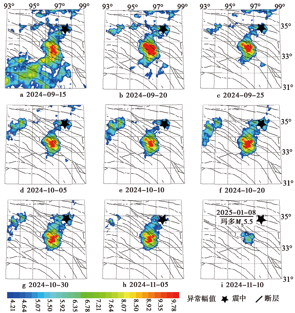
Fig. 3 Thermal infrared anomalies before Maduo MS5.5 earthquake.
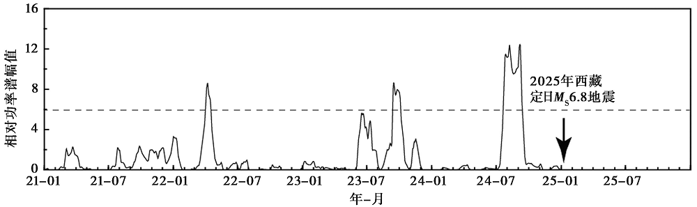
Fig. 4 Relative power spectrum time series curve before Dingri MS6.8 earthquake.
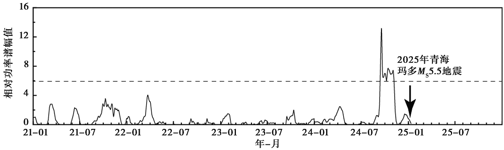
Fig. 5 Relative power spectrum time series curve before Maduo MS5.5 earthquake.

Fig. 6 Active fault distribution in southern Xizang.
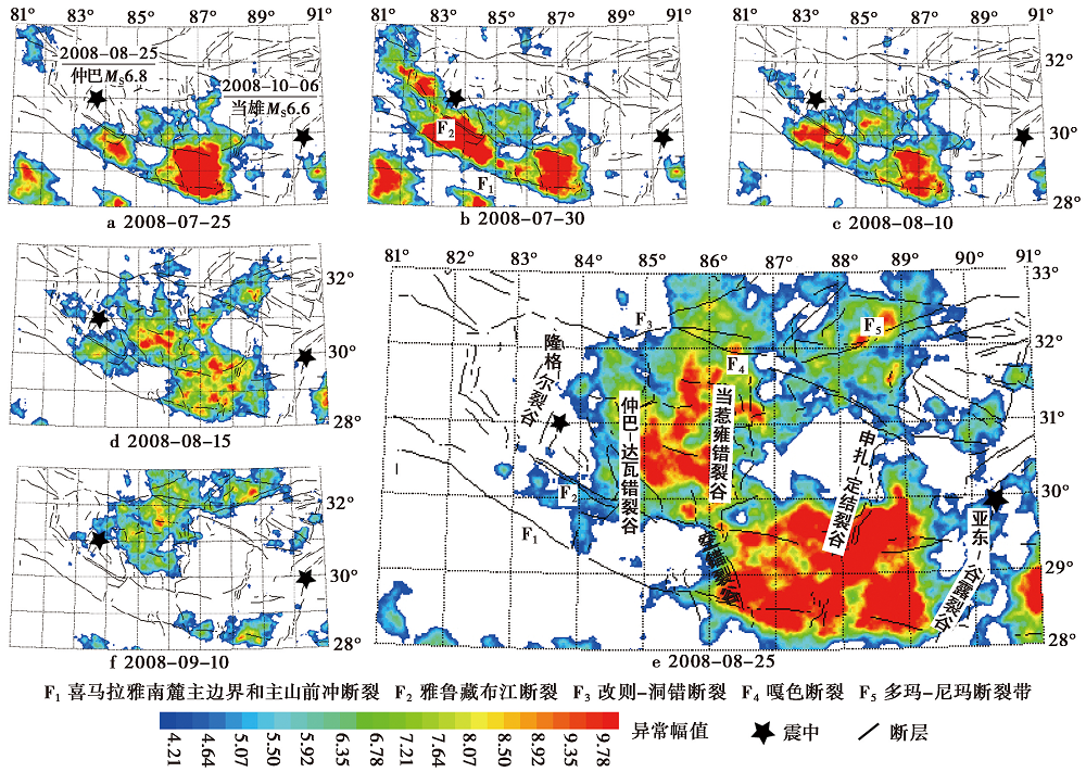
Fig. 7 Thermal infrared anomalies before Zhongba MS6.8 earthquake and Dangxiong MS6.6 earthquake.
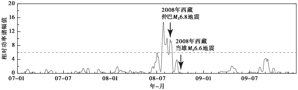
Fig. 8 Relative power spectrum time series curve before Zhongba MS6.8 and Dangxiong MS6.6 earthquakes.
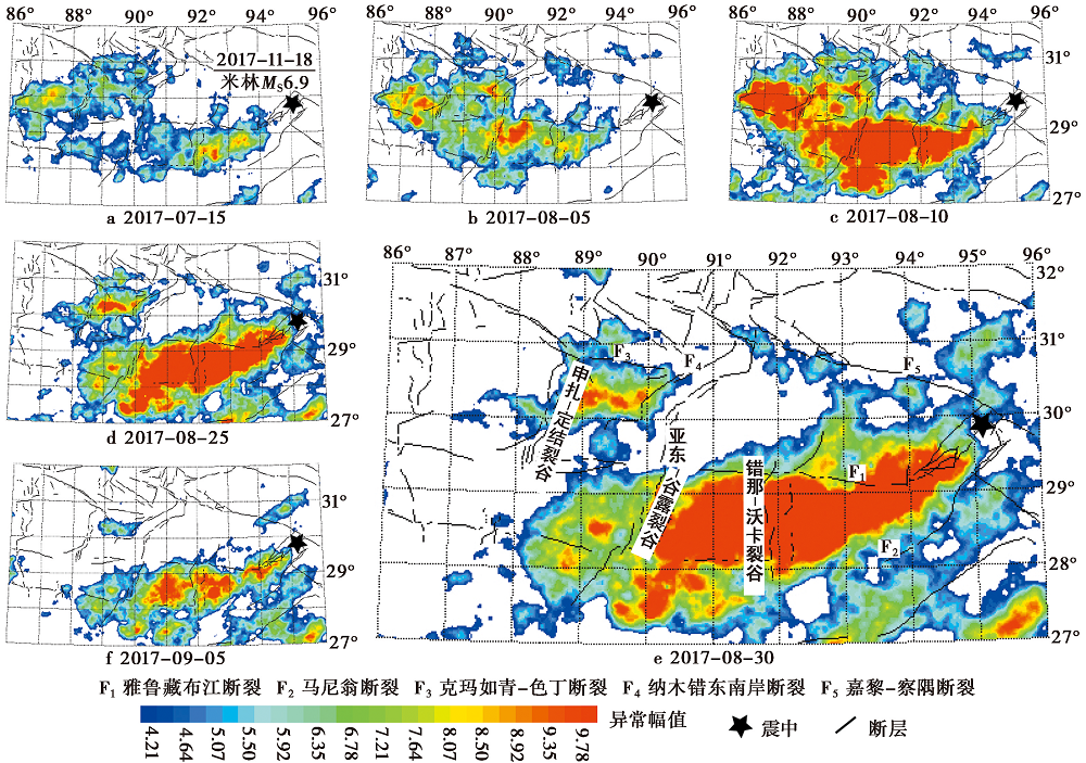
Fig. 9 Thermal infrared anomalies before Milin MS6.9 earthquake.
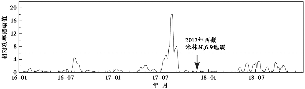
Fig. 10 Relative power spectrum time series curve before Milin MS6.9 earthquake.
| 地震基本信息 | 地震热红外异常特征 | |||||||
|---|---|---|---|---|---|---|---|---|
| 发震时间 | 发震地点 | 震级 /MS | 异常峰值 /倍 | 峰值出现时间 /d | 最大面积 /万平方千米 | 大于6倍的时间 /d | 与震中空间 位置关系 | |
| 2008-08-25 | 西藏仲巴 | 6.8 | 14.7 | 震前28d | 17 | 35 | 异常区边缘 | |
| 2008-10-06 | 西藏当雄 | 6.6 | 震前70d | 异常区边缘 | ||||
| 2017-11-18 | 西藏米林 | 6.9 | 18.2 | 震前97d | 20 | 34 | 异常区边缘 | |
| 2025-01-07 | 西藏定日 | 6.8 | 12.4 | 震前123d | 21 | 54 | 异常区边缘 | |
Table 1 Statistical summary of the thermal infrared anomaly characteristics
| 地震基本信息 | 地震热红外异常特征 | |||||||
|---|---|---|---|---|---|---|---|---|
| 发震时间 | 发震地点 | 震级 /MS | 异常峰值 /倍 | 峰值出现时间 /d | 最大面积 /万平方千米 | 大于6倍的时间 /d | 与震中空间 位置关系 | |
| 2008-08-25 | 西藏仲巴 | 6.8 | 14.7 | 震前28d | 17 | 35 | 异常区边缘 | |
| 2008-10-06 | 西藏当雄 | 6.6 | 震前70d | 异常区边缘 | ||||
| 2017-11-18 | 西藏米林 | 6.9 | 18.2 | 震前97d | 20 | 34 | 异常区边缘 | |
| 2025-01-07 | 西藏定日 | 6.8 | 12.4 | 震前123d | 21 | 54 | 异常区边缘 | |
| [1] |
陈梅花, 邓志辉, 马晓静, 等. 2007. 断裂带内外温差法在震前红外异常研究中的应用[J]. 地震地质, 29(4): 863-872.
|
|
|
|
| [2] |
陈杨. 2011. 地震红外遥感异常特征综合研究[D]. 北京: 中国地震局地震预测研究所.
|
|
|
|
| [3] |
邓起东, 张培震, 冉勇康, 等. 2002. 中国活动构造基本特征[J]. 中国科学(D辑), 32(12): 1020-1030.
|
|
|
|
| [4] |
邓志辉, 王煜, 陈梅花, 等. 2003. 中国大陆几次强地震活动的卫星红外异常分析[J]. 地震地质, 25(2): 327-337.
|
|
|
|
| [5] |
多布拉, 普穷, 洛桑罗布, 等. 2023. 西藏地震监测台网的建设与发展[J]. 地震地磁观测与研究, 44(2): 73-78.
|
|
|
|
| [6] |
郭晓, 张元生, 钟美娇, 等. 2010. 提取地震热异常信息的功率谱相对变化法及震例分析[J]. 地球物理学报, 53(11): 2688-2695.
|
|
|
|
| [7] |
郭瑛霞, 张丽峰, 郭昱琴, 等. 2023. 应用卫星热红外资料研究江苏及邻区地震热异常变化[J]. 华南地震, 43(3): 19-30.
|
|
|
|
| [8] |
韩同林. 1990. 试论藏南活动构造与地热的关系·喜马拉雅地质Ⅱ[M]. 北京: 地质出版社.
|
|
|
|
| [9] |
惠少兴, 魏从信, 金昭娣. 2019. 青藏高原东北缘2次地震热红外亮温异常分析[J]. 地震工程学报, 41(1): 177-182.
|
|
|
|
| [10] |
康春丽, 陈正位, 陈立泽, 等. 2003. 昆仑山口西8.1级地震的卫星热红外前兆特征分析[J]. 西北地震学报, 25(1): 12-15.
|
|
|
|
| [11] |
刘培洵, 刘力强, 陈顺云, 等. 2004. 地表岩石变形引起热红外辐射的实验研究[J]. 地震地质, 26(3): 502-511.
|
|
|
|
| [12] |
刘善军, 吴立新, 李金平, 等. 2007. 台湾恒春地震前的卫星热红外异常特征及其机理[J]. 科技导报, 25(6): 32-37.
|
|
|
|
| [13] |
强祖基, 孔令昌, 王弋平, 等. 1992. 地球放气、 热红外异常与地震活动[J]. 科学通报, 37(24): 2259-2262.
|
|
|
|
| [14] |
孙珂, 单新建,
DOI |
|
|
|
| [15] |
王鹏. 2013. 藏南碰撞造山带典型水热区现代地球化学过程与小流域CO2源、 汇关系研究[D]. 重庆: 西南大学.
|
|
|
|
| [16] |
王淑艳, 田辉, 马克祥, 等. 2021. 青海玛多 MS7.4 地震前LURR与OLR短临异常关联性研究[J]. 地震工程学报, 43(4): 847-852.
|
|
|
|
| [17] |
魏从信. 2011. 地震热辐射研究[D]. 兰州: 中国地震局兰州地震研究所.
|
|
|
|
| [18] |
吴立新, 李国华, 吴焕萍. 2001. 热红外成像用于固体撞击瞬态过程监测的实验探索[J]. 科学通报, 46(2): 172-176.
|
|
|
|
| [19] |
解滔, 郑晓东, 康春丽, 等. 2015. 2014年2月12日新疆于田 MS7.3 地震热红外亮温异常分析[J]. 中国地震, 31(1): 101-109.
|
|
|
|
| [20] |
徐纪人, 赵志新, 石川有三. 2005. 青藏高原中南部岩石圈扩张应力场与羊八井地热异常形成机制[J]. 地球物理学报, 48(4): 861-869.
|
|
|
|
| [21] |
张桉赫, 钟美娇, 艾萨·伊斯马伊力, 等. 2024. 新疆及周边地区地震热红外异常[J]. 地震地质, 46(5): 1192-1206. doi: 10.3969/i.issn.0253-4967.2024.05.011.
|
|
DOI |
|
| [22] |
张铁宝, 杨星, 路茜, 等. 2023. 巴颜喀拉块体中东段MS≥7.0地震卫星红外辐射时间序列变化特征[J]. 地球物理学报, 66(4): 1497-1505.
|
|
|
|
| [23] |
张元生, 郭晓, 钟美娇, 等. 2010. 汶川地震卫星热红外亮温变化[J]. 科学通报, 55(10): 904-910.
|
|
|
|
| [24] |
张志宏, 焦明若, 张丽, 等. 2021. 吉林松原地区地震前热红外亮温异常研究[J]. 大地测量与地球动力学, 41(6): 595-599.
|
|
|
|
| [25] |
钟美娇, 张元生, 廖洪月, 等. 2024. 2023年积石山6.2级地震热红外异常研究[J]. 地震工程学报, 46(4): 880-887.
|
|
|
|
| [26] |
|
| [27] |
|
| [28] |
|
| [29] |
|
| [30] |
|
| [31] |
|
| [32] |
|
| [33] |
|
| [34] |
|
| [35] |
|
| [36] |
|
| [37] |
|
| [38] |
|
| [39] |
|
| [1] | DU Hao-guo, ZUO Xiao-qing, LIN Xu-chuan, XIAO Ben-fu, LU Yong-kun, HE Shi-fang, ZHANG Fang-hao, YUAN Xiao-xiang, TAO Tian-yan, YE Yang, DENG Shu-rong, ZHAO Zheng-xian, XU Jun-zu, BAI Xian-fu, ZHANG Yuan-shuo, ZHANG Lu-lu. TEXTURE FEATURE DAMAGE DETECTION OF SINGLE BUILD-ING BASED ON DRONE IMAGES AFTER EARTHQUAKE: A CASE STUDY OF 2025 DINGRI MS6.8 EARTHQUAKE IN XIZANG, CHINA [J]. SEISMOLOGY AND GEOLOGY, 2025, 47(3): 949-968. |
| [2] | JI Zhi-wei, YU Hou-yun, LI Zong-chao, JU Chang-hui, SUN Yao-chong, ZHANG Yong-xian, CHEN Xiao-fei. PRELIMINARY SIMULATION OF LONG-PERIOD GROUND MOTION OF THE DINGRI MS6.8 EARTHQUAKE ON JANUARY 7, 2025 [J]. SEISMOLOGY AND GEOLOGY, 2025, 47(3): 917-931. |
| [3] | YIN Xiao-fei, QIANG Sheng-yin, ZHANG Wei, SHAO Zhi-gang, WANG Wu-xing, YUAN Xiao-xiang, LI Yong-sheng, LIU Hao. RESEARCH ON GROUND MOTION SIMULATION OF THE DINGRI MS6.8 EARTHQUAKE IN XIZANG BASED ON DIFFERENT SOURCE MODELS [J]. SEISMOLOGY AND GEOLOGY, 2025, 47(3): 897-916. |
| [4] | WU Xiao-fei, MENG Ling-yuan. COMPARISON OF THE CHARACTERISTICS OF EARTHQUAKE SEQUENCE AND INTENSITY OF THE JANUARY 7, 2025 MS6.8 DINGRI EARTHQUAKE IN XIZANG [J]. SEISMOLOGY AND GEOLOGY, 2025, 47(3): 869-880. |
| [5] | QIAO Jun-xiang, SHI Feng, LI An, LI Tao, ZHANG Da, WANG Xin, Gesangdanzhen, SUN Hao-yue. COSEISMIC SURFACE RUPTURE OF THE MS6.8 DINGRI EARTHQUAKE IN XIZANG, CHINA, BASED ON GF IMAGERY INTERPRETATION [J]. SEISMOLOGY AND GEOLOGY, 2025, 47(3): 789-805. |
| [6] | XU Yue-yi, XU Bei-bei, XU Chen-yu, SHAO Zhi-gang, HU Chao-zhong. JOINT INVERSION OF THE 2025 DINGRI MS6.8 EARTHQUAKE RUPTURE PROCESS BASED ON TELESEISMIC P WAVES, STRONG-MOTION AND INSAR DATA [J]. SEISMOLOGY AND GEOLOGY, 2025, 47(3): 734-746. |
| [7] | WANG Duo, CHEN Li-chun, LI Yan-bao, WANG Hu, JIA Yong-shun, GAO Yin-yi, XUE Ke-yi. LATE QUATERNARY ACTIVITY OF THE XIETONGMEN TO DENGMECUO SEGMENT ALONG THE XAINZA-DINGGYE RIFT IN SOUTHERN QINGHAI-XIZANG PLATEAU [J]. SEISMOLOGY AND GEOLOGY, 2025, 47(3): 718-733. |
| [8] | GAO Yang, WU Zhong-hai, HAN Shuai, TIAN Ting-ting. LATE QUATERNARY THROW RATE OF THE SEISMOGENIC FAULT(DENGMECUO FAULT)OF THE 2025 MS6.8 DINGRI EARTHQUAKE IN SHIGATSE [J]. SEISMOLOGY AND GEOLOGY, 2025, 47(3): 689-706. |
| [9] | GUO Zhao-wu, LU Ren-qi, ZHANG Jin-yu, FANG Li-hua, LIU Guan-shen, WU Xi-yan, SUN Xiao, QI Shi-miao. THREE-DIMENSIONAL MODEL OF SEISMOGENIC FAULT AND SEISMIC ENVIRONMENT OF XIZANG DINGRI MS6.8 EARTHQUAKE OF JANUARY 7, 2025 [J]. SEISMOLOGY AND GEOLOGY, 2025, 47(3): 671-688. |
| [10] | LIANG Ming-jian, DONG Yun-xi, ZUO Hong, DAI You-lin, XIAO Ben-fu, LIAO Cheng, TAN Ling, WANG Yu-wei, LI Xiang, TANG Cai-cheng, ZHANG Wei, ZHANG Hui-ping, MENG Ling-yuan, SU Jin-rong, WU Wei-wei, LI Chuan-you, YAN Mei. SURFACE DEFORMATION CHARACTERISTICS AND CAUSES OF THE DENGMECUO SEGMENT IN THE XIZANG DINGRI MS6.8 EARTHQUAKE [J]. SEISMOLOGY AND GEOLOGY, 2025, 47(1): 80-89. |
| [11] | WEI Ben-yong, ZHANG Yu-man, SHI Feng, QIAO Jun-xiang, WANG Xin, ZHANG Da. ANALYSIS OF BUILDING DAMAGE AND CASUALTIES OF THE 2025 DINGRI MS6.8 EARTHQUAKE IN XIZANG BASED ON FIELD INVESTIGATION [J]. SEISMOLOGY AND GEOLOGY, 2025, 47(1): 64-79. |
| [12] | YANG Jian-wen, JIN Ming-pei, YE Beng, LI Zhen-ling, LI Qing. SOURCE RUPTURE MECHANISM AND STRESS CHANGES TO THE ADJACENT AREA OF JANUARY 7, 2025, MS6.8 DINGRI EARTHQUAKE, XIZANG, CHINA [J]. SEISMOLOGY AND GEOLOGY, 2025, 47(1): 36-48. |
| [13] | ZOU Jun-jie, SHAO Zhi-gang, HE Hong-lin, GAO Lu, XU Yue-yi, DOU Ai-xia, LIANG Ze-yu. SURFACE RUPTURE INTERPRETATION AND BUILDING DAMAGE ASSESSMENT OF XIZANG DINGRI MS6.8 EARTHQUAKE ON JANUARY 7, 2025 [J]. SEISMOLOGY AND GEOLOGY, 2025, 47(1): 16-35. |
| [14] | SHI Feng, LIANG Ming-jian, LUO Quan-xing, QIAO Jun-xiang, ZHANG Da, WANG Xin, YI Wen-xing, ZHANG Jia-wei, ZHANG Ying-feng, ZHANG Hui-ping, LI Tao, LI An. SEISMOGENIC FAULT AND COSEISMIC SURFACE DEFORMATION OF THE DINGRI MS6.8 EARTHQUAKE IN XIZANG, CHINA [J]. SEISMOLOGY AND GEOLOGY, 2025, 47(1): 1-15. |
| Viewed | ||||||
|
Full text |
|
|||||
|
Abstract |
|
|||||
Copyright © SEISMOLOGY AND GEOLOGY, All Rights Reserved.
Tel: 010-62009049/9063 E-mail: dzdz@ies.ac.cn
Powered by Beijing Magtech Co., Ltd.