
SEISMOLOGY AND GEOLOGY ›› 2025, Vol. 47 ›› Issue (3): 949-968.DOI: 10.3969/j.issn.0253-4967.2025.03.20250026
Previous Articles Next Articles
TEXTURE FEATURE DAMAGE DETECTION OF SINGLE BUILD-ING BASED ON DRONE IMAGES AFTER EARTHQUAKE: A CASE STUDY OF 2025 DINGRI MS6.8 EARTHQUAKE IN XIZANG, CHINA
DU Hao-guo1,2)( ), ZUO Xiao-qing1),*(), LIN Xu-chuan3), XIAO Ben-fu4), LU Yong-kun2), HE Shi-fang2), ZHANG Fang-hao2), YUAN Xiao-xiang3,5), TAO Tian-yan6), YE Yang2), DENG Shu-rong2), ZHAO Zheng-xian2), XU Jun-zu2), BAI Xian-fu2), ZHANG Yuan-shuo2), ZHANG Lu-lu4)
- 1)Faculty of Land Resources Engineering, Kunming University of Science and Technology, Kunming 650093, China
2)Yunnan Earthquake Agency, Kunming 650225, China
3)Institute of Engineering Mechanics, CEA, Harbin 150080, China
4)Sichuan Earthquake Agency, Chengdu 610041, China
5)Key Laboratory of Earthquake Engineering and Engineering Vibration, China Earthquake Administration, Harbin 150080, China
6)Zhaoyang District Earthquake Prevention and Disaster Mitigation Bureau, Zhaotong 657000, China
-
Received:2025-01-25Revised:2025-05-06Online:2025-06-20Published:2025-08-13
基于震后无人机影像的单体建筑物纹理特征损伤检测——以2025年西藏定日县 MS6.8 地震为例
杜浩国1,2)(), 左小清1),*(), 林旭川3), 肖本夫4), 卢永坤2), 和仕芳2), 张方浩2), 袁小祥3,5), 陶天艳6), 叶阳2), 邓树荣2), 赵正贤2), 徐俊祖2), 白仙富2), 张原硕2), 张露露4)
- 1)昆明理工大学, 国土资源工程学院, 昆明 650093
2)云南省地震局, 昆明 650225
3)中国地震局工程力学研究所, 哈尔滨 150080
4)四川省地震局, 成都 610041
5)中国地震局地震工程与工程振动重点实验室, 哈尔滨 150080
6)昭阳区防震减灾局, 昭通 657000
-
通讯作者:*左小清, 男, 1972年生, 博士, 教授, 主要从事雷达干涉测量与地质灾害监测、 识别, E-mail: zxq@kust.edu.cn。 -
作者简介:杜浩国, 男, 1991年生, 现为昆明理工大学国土资源工程学院资源与环境专业在读博士研究生, 高级工程师, 主要从事震后影像建筑物破坏识别、 地震灾害损失评估研究, E-mail: 1364125834@qq.com。
-
基金资助:地震科技星火计划(XH23035YB); 国家自然科学基金(42471483); 国家自然科学基金(42161067); 局科技创新团队(CXTD202409); 地震信息青年重点任务(CEAITNS202410)
Cite this article
DU Hao-guo, ZUO Xiao-qing, LIN Xu-chuan, XIAO Ben-fu, LU Yong-kun, HE Shi-fang, ZHANG Fang-hao, YUAN Xiao-xiang, TAO Tian-yan, YE Yang, DENG Shu-rong, ZHAO Zheng-xian, XU Jun-zu, BAI Xian-fu, ZHANG Yuan-shuo, ZHANG Lu-lu. TEXTURE FEATURE DAMAGE DETECTION OF SINGLE BUILD-ING BASED ON DRONE IMAGES AFTER EARTHQUAKE: A CASE STUDY OF 2025 DINGRI MS6.8 EARTHQUAKE IN XIZANG, CHINA[J]. SEISMOLOGY AND GEOLOGY, 2025, 47(3): 949-968.
杜浩国, 左小清, 林旭川, 肖本夫, 卢永坤, 和仕芳, 张方浩, 袁小祥, 陶天艳, 叶阳, 邓树荣, 赵正贤, 徐俊祖, 白仙富, 张原硕, 张露露. 基于震后无人机影像的单体建筑物纹理特征损伤检测——以2025年西藏定日县 MS6.8 地震为例[J]. 地震地质, 2025, 47(3): 949-968.
share this article
Add to citation manager EndNote|Ris|BibTeX
URL: https://www.dzdz.ac.cn/EN/10.3969/j.issn.0253-4967.2025.03.20250026
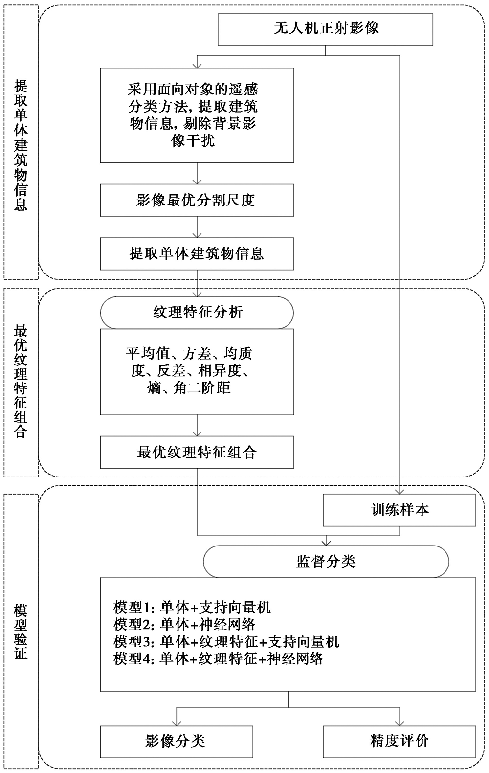
Fig. 1 Technical flowchart of this study.
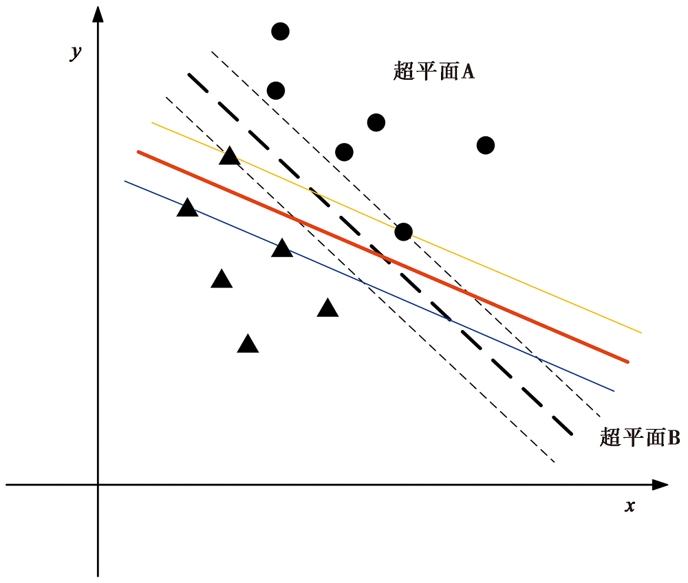
Fig. 2 Optimal classification hyperplane.
| 模型 | 参数 | 值/设置 | 选择原因 |
|---|---|---|---|
| 支持 向量机 | 核函数 | 径向基函数(RadialBasisFunction,RBF) | 适用于非线性分类问题,适合遥感影像中的复杂光谱特征 |
| γ | 0.333 | 较小的γ使模型对远距离样本更加敏感,捕捉全局特征 | |
| 惩罚参数(C) | 100 | 较高的C值更强调分类的准确性 | |
| 金字塔层级 | 0 | 避免因降采样导致的信息丢失 | |
| 分类概率阈值 | 0 | 所有像素都会被分类,适用于全覆盖分类任务 |
Table 1 Specific parameter settings of support vector machine classification method
| 模型 | 参数 | 值/设置 | 选择原因 |
|---|---|---|---|
| 支持 向量机 | 核函数 | 径向基函数(RadialBasisFunction,RBF) | 适用于非线性分类问题,适合遥感影像中的复杂光谱特征 |
| γ | 0.333 | 较小的γ使模型对远距离样本更加敏感,捕捉全局特征 | |
| 惩罚参数(C) | 100 | 较高的C值更强调分类的准确性 | |
| 金字塔层级 | 0 | 避免因降采样导致的信息丢失 | |
| 分类概率阈值 | 0 | 所有像素都会被分类,适用于全覆盖分类任务 |
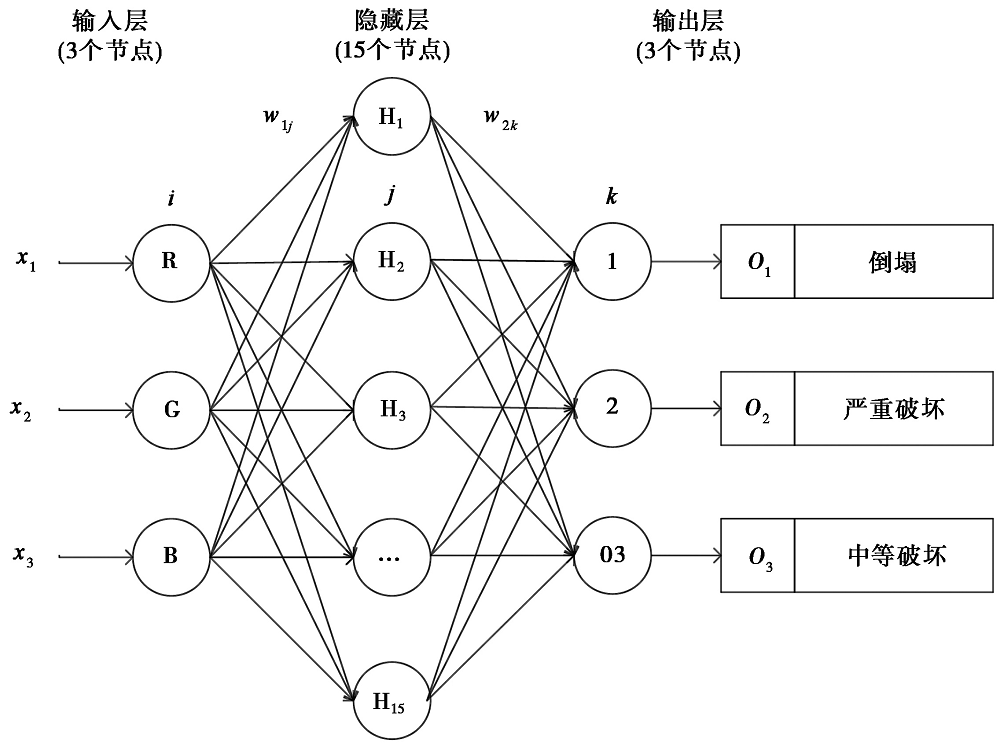
Fig. 3 Neural network diagram.
| 模型 | 参数 | 值或设置 | 选择原因 |
|---|---|---|---|
| 神经 网络 | 输入层节点数 | 3(RGB波段) | 捕捉RGB波段的光谱信息 |
| 隐藏层节点数 | 15 | 通过多次实验确定,能够有效提取高阶特征 | |
| 输出层节点数 | 3(3类震害等级) | 对应倒塌、严重破坏、中等破坏及轻微/无破坏4类震害等级 | |
| 隐藏层激活函数 | Logistic(sigmoid) | 适用于非线性特征提取 | |
| 输出层激活函数 | Softmax | 适用于多分类问题的概率输出 | |
| 贡献阈值 | 0.9 | 强化误差较大样本的权重更新力度,提升模型收敛速度 | |
| 学习率 | 0.2 | 适中取值,保证训练效率的同时避免参数震荡 | |
| 动量参数 | 0.9 | 加速梯度下降过程,降低训练过程中的震荡现象 | |
| 训练停止条件 | RMS<0.1 | 防止过拟合,确保模型在训练集和验证集上均能取得较好的分类效果 | |
| 最大训练迭代次数 | 1000次 | 为模型收敛提供充分的训练空间 |
Table2 Specific parameter settings of neural network classification method
| 模型 | 参数 | 值或设置 | 选择原因 |
|---|---|---|---|
| 神经 网络 | 输入层节点数 | 3(RGB波段) | 捕捉RGB波段的光谱信息 |
| 隐藏层节点数 | 15 | 通过多次实验确定,能够有效提取高阶特征 | |
| 输出层节点数 | 3(3类震害等级) | 对应倒塌、严重破坏、中等破坏及轻微/无破坏4类震害等级 | |
| 隐藏层激活函数 | Logistic(sigmoid) | 适用于非线性特征提取 | |
| 输出层激活函数 | Softmax | 适用于多分类问题的概率输出 | |
| 贡献阈值 | 0.9 | 强化误差较大样本的权重更新力度,提升模型收敛速度 | |
| 学习率 | 0.2 | 适中取值,保证训练效率的同时避免参数震荡 | |
| 动量参数 | 0.9 | 加速梯度下降过程,降低训练过程中的震荡现象 | |
| 训练停止条件 | RMS<0.1 | 防止过拟合,确保模型在训练集和验证集上均能取得较好的分类效果 | |
| 最大训练迭代次数 | 1000次 | 为模型收敛提供充分的训练空间 |
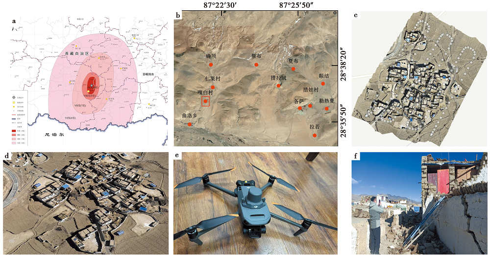
Fig. 4 Image data and equipment information in investigation of the magnitude 6.8 earthquake in Dingri, Xizang.
| 飞机性能 | 技术参数 | 飞机性能 | 技术参数 |
|---|---|---|---|
| 型号 | 大疆Mavic3E | 航线重叠率 | 70% |
| 飞行高度 | 150m | 旁向重叠率 | 80% |
| 飞行时长 | ≤18min | 总成像面积 | 0.073km2 |
| 飞行速度 | ≥20km/h | 影像格式 | TIFF(DOM) |
| 飞行架次 | 1架次 | 航拍照片数量 | 161张 |
| 地面分辨率 | 0.015m | 影像大小 | 18085×17968像素 |
| RTK定位模式 | 实时差分定位 | RTK平面精度 | ±1cm |
| RTK定位频率 | 1Hz | RTK高程精度 | ±2cm |
Table3 UAV equipment parameters
| 飞机性能 | 技术参数 | 飞机性能 | 技术参数 |
|---|---|---|---|
| 型号 | 大疆Mavic3E | 航线重叠率 | 70% |
| 飞行高度 | 150m | 旁向重叠率 | 80% |
| 飞行时长 | ≤18min | 总成像面积 | 0.073km2 |
| 飞行速度 | ≥20km/h | 影像格式 | TIFF(DOM) |
| 飞行架次 | 1架次 | 航拍照片数量 | 161张 |
| 地面分辨率 | 0.015m | 影像大小 | 18085×17968像素 |
| RTK定位模式 | 实时差分定位 | RTK平面精度 | ±1cm |
| RTK定位频率 | 1Hz | RTK高程精度 | ±2cm |
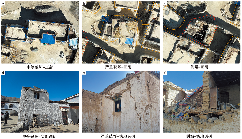
Fig. 5 Typical examples of buildings with different damage degree.
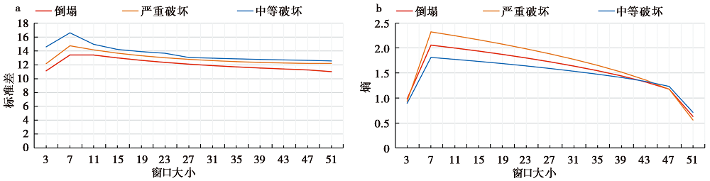
Fig. 6 The variation curve of window size, standard deviation and entropy of gray co-occurrence matrix.
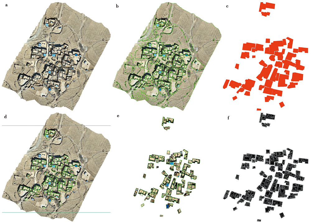
Fig. 7 Image preprocessing.
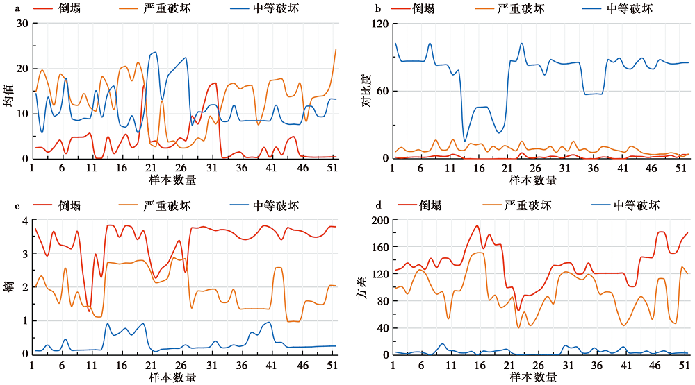
Fig. 8 Variation curves of texture characteristic values of buildings with different damage degrees.
| 参数设置 | 参数设置 | ||
|---|---|---|---|
| 如果 | 如果 | ||
| 规则1 | 分割与合并尺度:90~95 | 规则1 | 分割与合并尺度:90~95 |
| 规则2 | 30<灰度平均值<200 | 规则2 | 30<灰度平均值<200 |
| 规则3 | 10m2<面积<500m2 | 规则3 | 10m2<面积<500m2 |
| 规则4 | 小面积去除与形态学闭合 |
Table4 Single building image extraction rules
| 参数设置 | 参数设置 | ||
|---|---|---|---|
| 如果 | 如果 | ||
| 规则1 | 分割与合并尺度:90~95 | 规则1 | 分割与合并尺度:90~95 |
| 规则2 | 30<灰度平均值<200 | 规则2 | 30<灰度平均值<200 |
| 规则3 | 10m2<面积<500m2 | 规则3 | 10m2<面积<500m2 |
| 规则4 | 小面积去除与形态学闭合 |
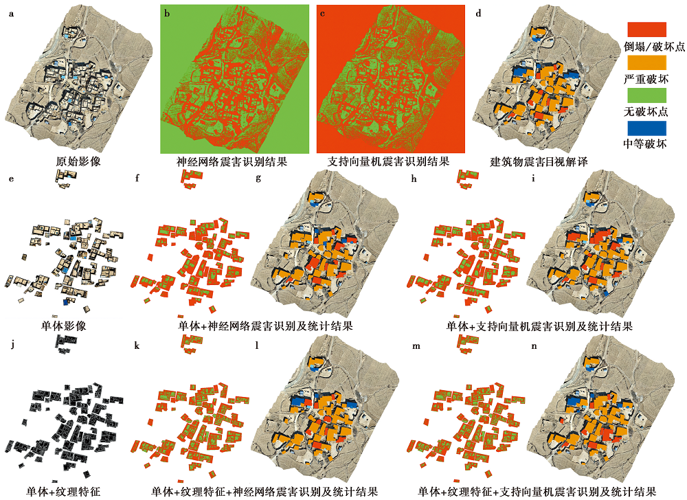
Fig. 9 Building damage detection results with different models.
| 建筑物破坏结果统计 | 建筑物影像破坏特征 | ||
|---|---|---|---|
| 破坏点占比(红色) | 无破坏点占比(绿色) | ||
| 如果(红色>30%) | 倒塌(红色) | 从正射影像中可以看到废墟堆积、纹理不均匀及影像色调较浅。 | |
| 如果(红色≤30%) | 如果(绿色≤90%) | 严重破坏(黄色) | 在正射影像中可以观察到建筑物轮廓不清晰,阴影消失,并显示出局部倒塌形成的废墟堆积,影像色调较浅。 |
| 如果(红色≤30%) | 如果(绿色>90%) | 中等破坏(蓝色) | 从正射影像中可以观察到单体建筑物轮廓清晰、形状规则,但屋顶部分破坏导致了影像的纹理特征发生轻微变化。 |
Table5 Rules for identifying damage degree of single building
| 建筑物破坏结果统计 | 建筑物影像破坏特征 | ||
|---|---|---|---|
| 破坏点占比(红色) | 无破坏点占比(绿色) | ||
| 如果(红色>30%) | 倒塌(红色) | 从正射影像中可以看到废墟堆积、纹理不均匀及影像色调较浅。 | |
| 如果(红色≤30%) | 如果(绿色≤90%) | 严重破坏(黄色) | 在正射影像中可以观察到建筑物轮廓不清晰,阴影消失,并显示出局部倒塌形成的废墟堆积,影像色调较浅。 |
| 如果(红色≤30%) | 如果(绿色>90%) | 中等破坏(蓝色) | 从正射影像中可以观察到单体建筑物轮廓清晰、形状规则,但屋顶部分破坏导致了影像的纹理特征发生轻微变化。 |
| 方法 | 序号 | 破坏等级 | 倒塌 | 严重破坏 | 中等破坏 | 合计/栋 | OA/% | Kappa |
|---|---|---|---|---|---|---|---|---|
| 单体+纹理特征+神经网络 | 1 | 倒塌 | 7 | 1 | 0 | 8 | 91 | 0.8 |
| 严重破坏 | 2 | 32 | 0 | 34 | ||||
| 中等破坏 | 0 | 1 | 4 | 5 | ||||
| 合计 | 9 | 34 | 4 | 47 | ||||
| 单体+纹理特征+支持向量机 | 2 | 倒塌 | 7 | 1 | 0 | 8 | 89 | 0.7 |
| 严重破坏 | 2 | 31 | 1 | 34 | ||||
| 中等破坏 | 0 | 1 | 4 | 5 | ||||
| 合计 | 9 | 33 | 5 | 47 | ||||
| 单体+神经网络结果 | 3 | 倒塌 | 7 | 1 | 0 | 8 | 85 | 0.6 |
| 严重破坏 | 3 | 30 | 1 | 34 | ||||
| 中等破坏 | 1 | 1 | 3 | 5 | ||||
| 合计 | 11 | 32 | 4 | 47 | ||||
| 单体+支持向量机 | 4 | 倒塌 | 7 | 1 | 0 | 8 | 82 | 0.6 |
| 严重破坏 | 3 | 30 | 1 | 34 | ||||
| 中等破坏 | 1 | 2 | 2 | 5 | ||||
| 合计 | 11 | 33 | 3 | 47 |
Table6 Evaluation result of single building damage detection based on confusion matrix
| 方法 | 序号 | 破坏等级 | 倒塌 | 严重破坏 | 中等破坏 | 合计/栋 | OA/% | Kappa |
|---|---|---|---|---|---|---|---|---|
| 单体+纹理特征+神经网络 | 1 | 倒塌 | 7 | 1 | 0 | 8 | 91 | 0.8 |
| 严重破坏 | 2 | 32 | 0 | 34 | ||||
| 中等破坏 | 0 | 1 | 4 | 5 | ||||
| 合计 | 9 | 34 | 4 | 47 | ||||
| 单体+纹理特征+支持向量机 | 2 | 倒塌 | 7 | 1 | 0 | 8 | 89 | 0.7 |
| 严重破坏 | 2 | 31 | 1 | 34 | ||||
| 中等破坏 | 0 | 1 | 4 | 5 | ||||
| 合计 | 9 | 33 | 5 | 47 | ||||
| 单体+神经网络结果 | 3 | 倒塌 | 7 | 1 | 0 | 8 | 85 | 0.6 |
| 严重破坏 | 3 | 30 | 1 | 34 | ||||
| 中等破坏 | 1 | 1 | 3 | 5 | ||||
| 合计 | 11 | 32 | 4 | 47 | ||||
| 单体+支持向量机 | 4 | 倒塌 | 7 | 1 | 0 | 8 | 82 | 0.6 |
| 严重破坏 | 3 | 30 | 1 | 34 | ||||
| 中等破坏 | 1 | 2 | 2 | 5 | ||||
| 合计 | 11 | 33 | 3 | 47 |
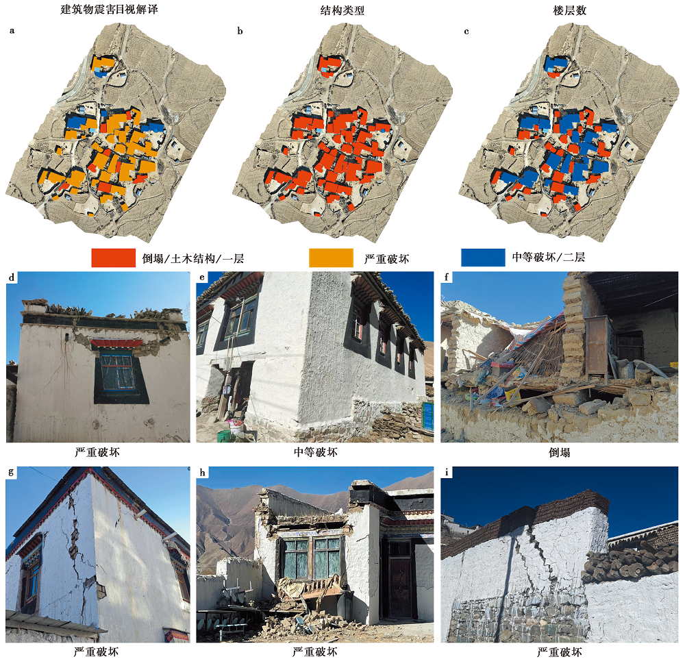
Fig. 10 The building damage degree from the image interpretation of Gabai village.
| 破坏类型 | 不同楼层数数量(栋)及占比/% | 不同结构类型数量(栋)及占比/% | ||
|---|---|---|---|---|
| 一层 | 二层 | 土木结构 | 砖混结构 | |
| 倒塌 | 8, 17 | 0, 0 | 8, 17 | 0, 0 |
| 严重破坏 | 19, 41 | 15, 32 | 34, 72 | 0, 0 |
| 中等破坏 | 3, 6 | 2, 4 | 5, 11 | 0, 0 |
| 合计 | 30, 64 | 17, 36 | 47, 100 | 0, 0 |
Table7 Number and proportion of building floors and structures
| 破坏类型 | 不同楼层数数量(栋)及占比/% | 不同结构类型数量(栋)及占比/% | ||
|---|---|---|---|---|
| 一层 | 二层 | 土木结构 | 砖混结构 | |
| 倒塌 | 8, 17 | 0, 0 | 8, 17 | 0, 0 |
| 严重破坏 | 19, 41 | 15, 32 | 34, 72 | 0, 0 |
| 中等破坏 | 3, 6 | 2, 4 | 5, 11 | 0, 0 |
| 合计 | 30, 64 | 17, 36 | 47, 100 | 0, 0 |
| [1] |
陈启浩, 聂宇靓, 李林林, 等. 2017. 极化分解后多纹理特征的建筑物损毁评估[J]. 遥感学报, 21(6): 955-965.
|
|
|
|
| [2] |
杜浩国, 林旭川, 张建国, 等. 2021. 基于改进蚁群算法与无人机影像的震害识别方法及其在漾濞地震中的应用[J]. 地震地质, 43(4): 1013-1029. doi: 10.3969/j.issn.0253-4967.2021.04.018.
|
|
DOI |
|
| [3] |
范熙伟, 聂高众, 邓砚, 等. 2017. 基于摄影测量技术的房屋提取方法——以中国西部地区乡村为例[J]. 地震地质, 39(4): 805-818. doi: 10.3969/j.issn.0253-4967.2017.04.014.
|
|
DOI |
|
| [4] |
李东臣, 任俊杰, 张志文, 等. 2022. 基于高分辨率无人机影像的地震地表破裂半自动提取方法——以2021年 MS7.4 青海玛多地震为例[J]. 地震地质, 44(6): 1484-1502. doi: 10.3969/j.issn.0253-4967.2022.06.008.
|
|
DOI |
|
| [5] |
刘鑫, 王诗柔, 石许华, 等. 2024. 深度学习在活动构造与地貌研究中的应用[J]. 地震地质, 46(2): 277-296. doi: 10.3969/j.issn.0253-4967.2024.02.003.
|
|
DOI |
|
| [6] |
李强, 张景发, 龚丽霞, 等. 2018. SAR图像纹理特征相关变化检测的震害建筑物提取[J]. 遥感学报, 22(S1): 128-138.
|
|
|
|
| [7] |
李强, 张景发. 2016. 不同特征融合的震后损毁建筑物识别研究[J]. 地震研究, 39(3): 486-493, 527.
|
|
|
|
| [8] |
孙稳, 何宏林, 魏占玉, 等. 2019. 基于无人机航测获取高分辨率DEM数据的断层几何结构精细解译与分析——以海原断裂唐家坡为例[J]. 地震地质, 41(6): 1350-1365. doi: 10.3969/j.issn.0253-4967.2019.06.003.
|
|
DOI |
|
| [9] |
谭莎莎, 杨莹辉, 许强, 等. 2025. 2025年1月7日西藏定日县 MS6.8 强震地表同震形变特征与房屋建筑震损分析[J]. 成都理工大学学报(自然科学版), 52(2): 212-222.
|
|
|
|
| [10] |
肖本夫, 袁小祥, 陈波, 等. 2023. 基于倾斜摄影技术的典型情景可视化震害定量评估-以四川马尔康震群为例[J]. 地震地质, 45(4): 847-863. doi: 10.3969/j.issn.0253-4967.2023.04.003.
|
|
DOI |
|
| [11] |
薛明, 韦波, 李景文, 等. 2021. 优化BP神经网络的多特征融合遥感影像分类方法[J]. 测绘科学, 46(11): 47-55.
|
|
|
|
| [12] |
游永发, 王思远, 王斌, 等. 2019. 高分辨率遥感影像建筑物分级提取[J]. 遥感学报, 23(1): 125-136.
|
|
|
|
| [13] |
张雪华, 许建华, 严瑾, 等. 2024. 地震现场应急中的无人机技术应用及趋势——以甘肃积石山 MS6.2 地震为例[J]. 四川地震, (4): 8-13, 46.
|
|
|
|
| [14] |
张凌, 谭璇, 宋冬梅, 等. 2019. 基于马尔科夫随机场的单时相震害影像受损建筑物识别方法[J]. 地震地质, 41(5): 1273-1288. doi: 10.3969/j.issn.0253-4967.2019.05.014.
|
|
DOI |
|
| [15] |
|
| [16] |
|
| [17] |
|
| [18] |
|
| [19] |
|
| [20] |
|
| [21] |
|
| [22] |
|
| [23] |
|
| [24] |
|
| [1] | WANG Wan-tong, MA Si-yuan, YAN Wu-jian, YUAN Ren-mao. LANDSLIDE SUSCEPTIBILITY ASSESSMENT OF THE 2014 LUDIAN EARTHQUAKE: COMPARATIVE STUDY BASED ON CONVOLUTIONAL NEURAL NETWORK AND RANDOM FOREST [J]. SEISMOLOGY AND GEOLOGY, 2026, 48(2): 497-519. |
| [2] | XU Yue-yi, XU Bei-bei, XU Chen-yu, SHAO Zhi-gang, HU Chao-zhong. JOINT INVERSION OF THE 2025 DINGRI MS6.8 EARTHQUAKE RUPTURE PROCESS BASED ON TELESEISMIC P WAVES, STRONG-MOTION AND INSAR DATA [J]. SEISMOLOGY AND GEOLOGY, 2025, 47(3): 734-746. |
| [3] | WANG Duo, CHEN Li-chun, LI Yan-bao, WANG Hu, JIA Yong-shun, GAO Yin-yi, XUE Ke-yi. LATE QUATERNARY ACTIVITY OF THE XIETONGMEN TO DENGMECUO SEGMENT ALONG THE XAINZA-DINGGYE RIFT IN SOUTHERN QINGHAI-XIZANG PLATEAU [J]. SEISMOLOGY AND GEOLOGY, 2025, 47(3): 718-733. |
| [4] | GAO Yang, WU Zhong-hai, HAN Shuai, TIAN Ting-ting. LATE QUATERNARY THROW RATE OF THE SEISMOGENIC FAULT(DENGMECUO FAULT)OF THE 2025 MS6.8 DINGRI EARTHQUAKE IN SHIGATSE [J]. SEISMOLOGY AND GEOLOGY, 2025, 47(3): 689-706. |
| [5] | GUO Zhao-wu, LU Ren-qi, ZHANG Jin-yu, FANG Li-hua, LIU Guan-shen, WU Xi-yan, SUN Xiao, QI Shi-miao. THREE-DIMENSIONAL MODEL OF SEISMOGENIC FAULT AND SEISMIC ENVIRONMENT OF XIZANG DINGRI MS6.8 EARTHQUAKE OF JANUARY 7, 2025 [J]. SEISMOLOGY AND GEOLOGY, 2025, 47(3): 671-688. |
| [6] | QIAO Jun-xiang, SHI Feng, LI An, LI Tao, ZHANG Da, WANG Xin, Gesangdanzhen, SUN Hao-yue. COSEISMIC SURFACE RUPTURE OF THE MS6.8 DINGRI EARTHQUAKE IN XIZANG, CHINA, BASED ON GF IMAGERY INTERPRETATION [J]. SEISMOLOGY AND GEOLOGY, 2025, 47(3): 789-805. |
| [7] | WU Xiao-fei, MENG Ling-yuan. COMPARISON OF THE CHARACTERISTICS OF EARTHQUAKE SEQUENCE AND INTENSITY OF THE JANUARY 7, 2025 MS6.8 DINGRI EARTHQUAKE IN XIZANG [J]. SEISMOLOGY AND GEOLOGY, 2025, 47(3): 869-880. |
| [8] | YIN Xiao-fei, QIANG Sheng-yin, ZHANG Wei, SHAO Zhi-gang, WANG Wu-xing, YUAN Xiao-xiang, LI Yong-sheng, LIU Hao. RESEARCH ON GROUND MOTION SIMULATION OF THE DINGRI MS6.8 EARTHQUAKE IN XIZANG BASED ON DIFFERENT SOURCE MODELS [J]. SEISMOLOGY AND GEOLOGY, 2025, 47(3): 897-916. |
| [9] | JI Zhi-wei, YU Hou-yun, LI Zong-chao, JU Chang-hui, SUN Yao-chong, ZHANG Yong-xian, CHEN Xiao-fei. PRELIMINARY SIMULATION OF LONG-PERIOD GROUND MOTION OF THE DINGRI MS6.8 EARTHQUAKE ON JANUARY 7, 2025 [J]. SEISMOLOGY AND GEOLOGY, 2025, 47(3): 917-931. |
| [10] | ZHANG Li-feng, ZHONG Mei-jiao, PAN Yu-hang, GUO Ying-xia, SUN Xi-hao, ZHANG Yuan-sheng. STUDY ON THERMAL INFRARED ANOMALIES OF THE 2025 DINGRI MS6.8 EARTHQUAKE AND SEVERAL EARTHQUAKE CASES IN SOUTHERN XIZANG [J]. SEISMOLOGY AND GEOLOGY, 2025, 47(3): 984-998. |
| [11] | LIANG Ming-jian, DONG Yun-xi, ZUO Hong, DAI You-lin, XIAO Ben-fu, LIAO Cheng, TAN Ling, WANG Yu-wei, LI Xiang, TANG Cai-cheng, ZHANG Wei, ZHANG Hui-ping, MENG Ling-yuan, SU Jin-rong, WU Wei-wei, LI Chuan-you, YAN Mei. SURFACE DEFORMATION CHARACTERISTICS AND CAUSES OF THE DENGMECUO SEGMENT IN THE XIZANG DINGRI MS6.8 EARTHQUAKE [J]. SEISMOLOGY AND GEOLOGY, 2025, 47(1): 80-89. |
| [12] | WEI Ben-yong, ZHANG Yu-man, SHI Feng, QIAO Jun-xiang, WANG Xin, ZHANG Da. ANALYSIS OF BUILDING DAMAGE AND CASUALTIES OF THE 2025 DINGRI MS6.8 EARTHQUAKE IN XIZANG BASED ON FIELD INVESTIGATION [J]. SEISMOLOGY AND GEOLOGY, 2025, 47(1): 64-79. |
| [13] | YANG Jian-wen, JIN Ming-pei, YE Beng, LI Zhen-ling, LI Qing. SOURCE RUPTURE MECHANISM AND STRESS CHANGES TO THE ADJACENT AREA OF JANUARY 7, 2025, MS6.8 DINGRI EARTHQUAKE, XIZANG, CHINA [J]. SEISMOLOGY AND GEOLOGY, 2025, 47(1): 36-48. |
| [14] | ZOU Jun-jie, SHAO Zhi-gang, HE Hong-lin, GAO Lu, XU Yue-yi, DOU Ai-xia, LIANG Ze-yu. SURFACE RUPTURE INTERPRETATION AND BUILDING DAMAGE ASSESSMENT OF XIZANG DINGRI MS6.8 EARTHQUAKE ON JANUARY 7, 2025 [J]. SEISMOLOGY AND GEOLOGY, 2025, 47(1): 16-35. |
| [15] | SHI Feng, LIANG Ming-jian, LUO Quan-xing, QIAO Jun-xiang, ZHANG Da, WANG Xin, YI Wen-xing, ZHANG Jia-wei, ZHANG Ying-feng, ZHANG Hui-ping, LI Tao, LI An. SEISMOGENIC FAULT AND COSEISMIC SURFACE DEFORMATION OF THE DINGRI MS6.8 EARTHQUAKE IN XIZANG, CHINA [J]. SEISMOLOGY AND GEOLOGY, 2025, 47(1): 1-15. |
| Viewed | ||||||
|
Full text |
|
|||||
|
Abstract |
|
|||||
Copyright © SEISMOLOGY AND GEOLOGY, All Rights Reserved.
Tel: 010-62009049/9063 E-mail: dzdz@ies.ac.cn
Powered by Beijing Magtech Co., Ltd.