
SEISMOLOGY AND GEOLOGY ›› 2025, Vol. 47 ›› Issue (3): 897-916.DOI: 10.3969/j.issn.0253-4967.2025.03.20250038
Previous Articles Next Articles
RESEARCH ON GROUND MOTION SIMULATION OF THE DINGRI MS6.8 EARTHQUAKE IN XIZANG BASED ON DIFFERENT SOURCE MODELS
YIN Xiao-fei1)( ), QIANG Sheng-yin2), ZHANG Wei3),*(), SHAO Zhi-gang1), WANG Wu-xing1), YUAN Xiao-xiang1), LI Yong-sheng4), LIU Hao5)
- 1)Institute of Earthquake Forecasting, China Earthquake Administration, Beijing 100036, China
2)Institute of Engineering Mechanics, China Earthquake Administration, Harbin 150080, China
3)Department of Earth and Space Science, Southern University of Science and Technology, Shenzhen 518055, China
4)National Institute of Natural Disaster Prevention and Mitigation, Ministry of Emergency Management, Beijing 100085, China
5)Shanghai Research Institute of Building Sciences Company Limited, Shanghai 200032, China
-
Received:2025-01-26Revised:2025-02-11Online:2025-06-20Published:2025-08-13
基于不同震源模型的西藏定日 MS6.8 地震强地面运动模拟研究
尹晓菲1)(), 强生银2), 张伟3),*(), 邵志刚1), 王武星1), 袁小祥1), 李永生4), 刘浩5)
- 1)中国地震局地震预测研究所, 北京 100036
2)中国地震局工程力学研究所, 哈尔滨 150080
3)南方科技大学地球与空间科学系, 深圳 518055
4)应急管理部国家自然灾害防治研究院, 北京 100085
5)上海市建筑科学研究院有限公司, 上海 200032
-
通讯作者:*张伟, 男, 1976年生, 教授, 主要从事复杂介质地震波数值模拟算法和高性能计算、 内部结构成像、 地震和微地震监测等方面的研究, E-mail: zhangwei@sustech.edu.cn。 -
作者简介:尹晓菲, 女, 1989年生, 副研究员, 主要研究方向为强地面运动模拟、 高频面波方法、 地震活动等方面的研究, E-mail: yxf@cea-ies.ac.cn。
-
基金资助:国家重点研发计划项目(2023YFC3007304); 中国地震局地震预测研究所基本科研业务专项(CEAIEF2024030205)
Cite this article
YIN Xiao-fei, QIANG Sheng-yin, ZHANG Wei, SHAO Zhi-gang, WANG Wu-xing, YUAN Xiao-xiang, LI Yong-sheng, LIU Hao. RESEARCH ON GROUND MOTION SIMULATION OF THE DINGRI MS6.8 EARTHQUAKE IN XIZANG BASED ON DIFFERENT SOURCE MODELS[J]. SEISMOLOGY AND GEOLOGY, 2025, 47(3): 897-916.
尹晓菲, 强生银, 张伟, 邵志刚, 王武星, 袁小祥, 李永生, 刘浩. 基于不同震源模型的西藏定日 MS6.8 地震强地面运动模拟研究[J]. 地震地质, 2025, 47(3): 897-916.
share this article
Add to citation manager EndNote|Ris|BibTeX
URL: https://www.dzdz.ac.cn/EN/10.3969/j.issn.0253-4967.2025.03.20250038

Fig. 1 Topography and seismic location map of the study area as of 2025 Dingri MS6.8 earthquake, with the cutoff time for seismic epicenter distribution being January 22, 2025.
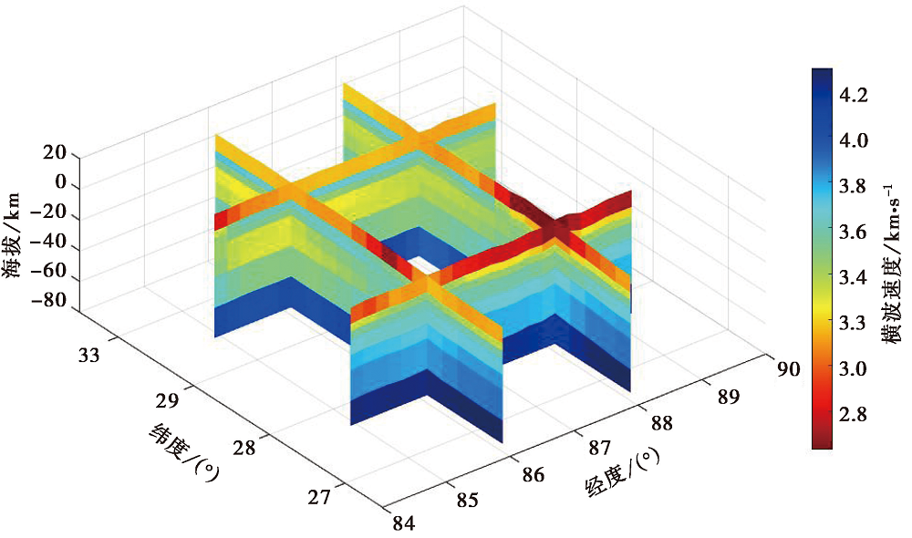
Fig. 2 Shear wave velocity structure of the study area.

Fig. 3 Fault slip distribution of the Dingri MS6.8 earthquake.

Fig. 4 Snapshots of the surface propagation wavefield of the Dingri MS6.8 earthquake simulated based on Source Model 1 in the EW, NS, and UD velocity components.

Fig. 5 Snapshots of the surface propagation wavefield of the Dingri MS6.8 earthquake simulated based on Source Model 2 in the EW, NS, and UD velocity components.
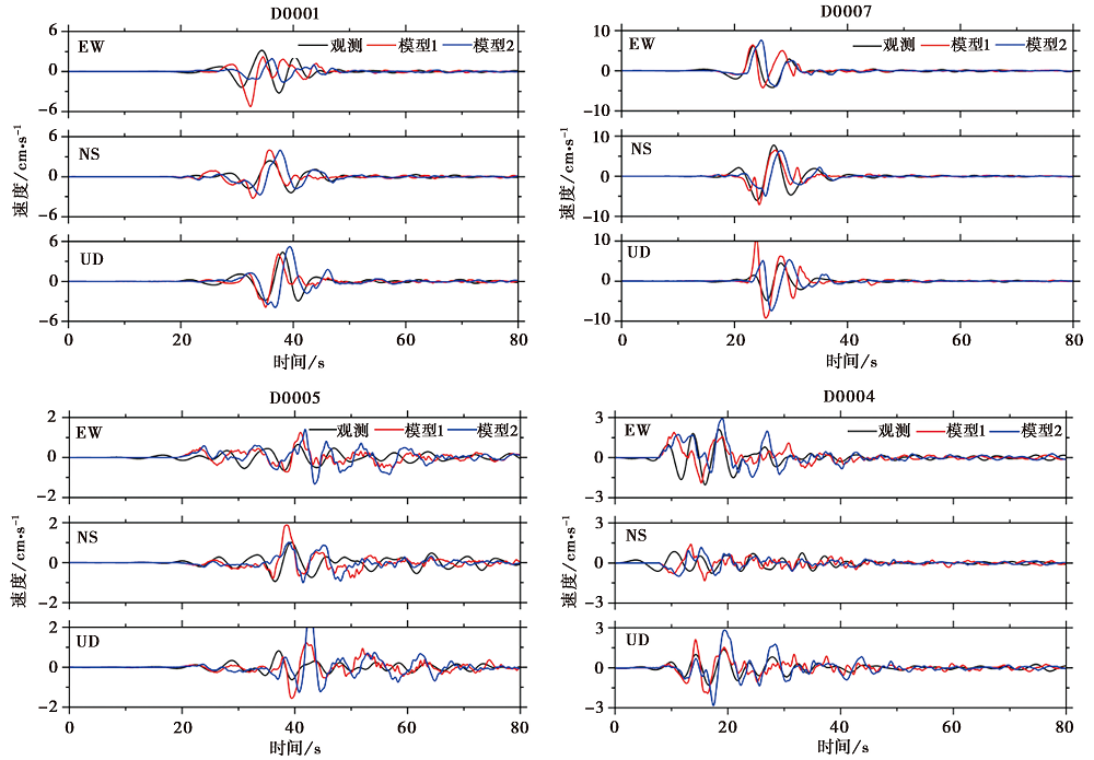
Fig. 6 Comparison of the three-component velocity time histories between the simulations from two source models and the observed data.
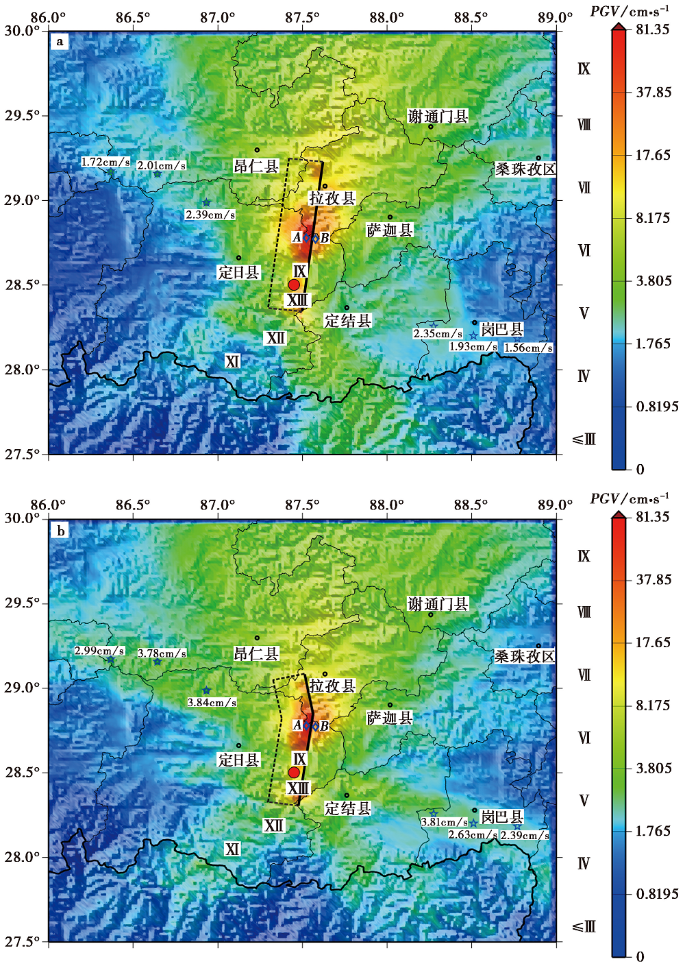
Fig. 7 Intensity distribution map of the Dingri MS6.8 earthquake simulated based on Source Model 1(a)and Source Model 2(b).
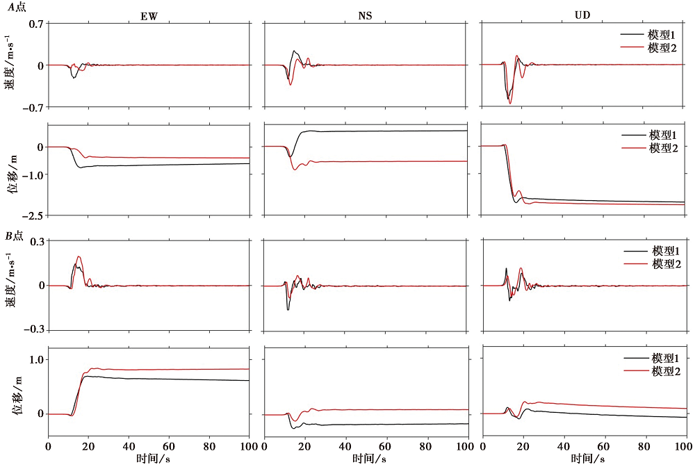
Fig. 8 Velocity and displacement time histories at point A on the upper plate and point B on the lower plate of the fault rupture surface.
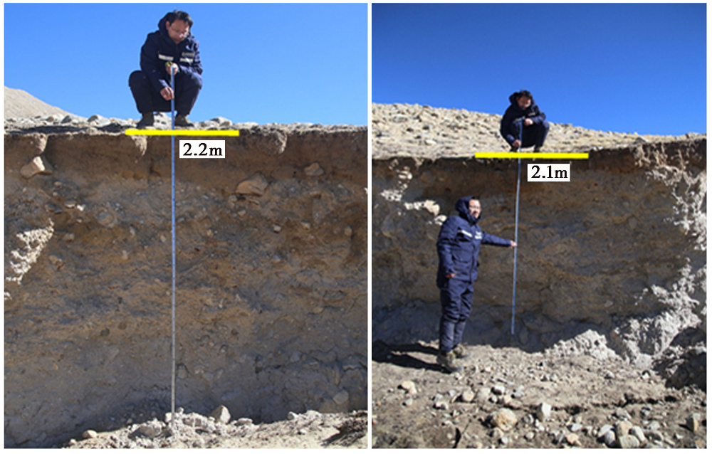
Fig. 9 Field investigation data of the surface rupture from the Dingri earthquake(provided by WU Yan-qiang).
| [1] |
巴振宁, 赵靖轩, 张郁山, 等. 2023. 基于GP14.3运动学混合震源模型和SPECFEM 3D谱元法的宽频地震动模拟[J]. 地球物理学报, 66(3): 1125-1138.
|
|
|
|
| [2] |
陈威, 乔学军, 刘刚, 等. 2018. 基于GNSS与InSAR约束的九寨沟 MS7.0 地震滑动模型及其库仑应力研究[J]. 地球物理学报, 61(5): 2122-2132.
DOI |
|
|
|
| [3] |
邓起东, 程绍平, 马冀, 等. 2014. 青藏高原地震活动特征及当前地震活动形势[J]. 地球物理学报, 57(7): 2025-2042.
DOI |
|
|
|
| [4] |
冯蔚, 刘杰, 罗佳宏, 等. 2018. 运用理论格林函数模拟新疆阿克陶6.7级地震强地面运动[J]. 地震地质, 40(4): 850-860. doi: 10.3969/j.issn.0253-4967.2018.04.009.
|
|
DOI |
|
| [5] |
国家市场监督管理局, 国家标准化管理委员会. 2021. 中国地震烈度表(GB/T17742-2020)[S]. 北京: 中国标准出版社: 1-11.
|
|
State Administration for Market Regulatory, Standardization Administration. 2021. China Seismic Intensity Scale(GB/T 17742-2020)[S]. China Standard Press, Beijing: 1-11 (in Chinese).
|
|
| [6] |
胡进军. 2010. 近断层地震动方向性效应及超剪切破裂研究[D]. 哈尔滨: 中国工程力学研究所: 1-257.
|
|
|
|
| [7] |
胡进军, 谢礼立. 2011. 地震破裂的方向性效应相关概念综述[J]. 地震工程与工程振动, 31(4): 1-8.
|
|
|
|
| [8] |
黄蓓, 张培震, 张冬丽, 等. 2015. 汶川8.0级特大地震的断裂特性与强地面运动的关系[J]. 地震地质, 37(4): 1055-1069. doi: 10.3969/j.issn.0253-4967.2015.04.010.
|
|
DOI |
|
| [9] |
黄婷, 吴中海, 韩帅, 等. 2024. 西藏日喀则地区的活断层基本特征及地震灾害潜在风险评估[J]. 地震科学进展, 54(10): 696-711.
|
|
|
|
| [10] |
纪志伟, 李宗超, 张琰, 等. 2024. 情景地震震源特征对速度脉冲分布的影响——以虎牙断层为例[J]. 地震地质, 46(5): 1207-1225. doi: 10.3969/j.issn.0253-4967.2024.05.012.
|
|
DOI |
|
| [11] |
李宗超, 孙吉泽, 纪志伟, 等. 2025. 2025年1月7日西藏定日 MS6.8 地震珠峰地震台加速度时程快速模拟[J]. 地球科学, 50(2): 798-804.
|
|
|
|
| [12] |
梁洪宝, 武艳强, 陈长云, 等. 2018. 2014年新疆于田 MS7.3 地震同震位移及位错反演研究[J]. 地球物理学报, 61(12): 4817-4826.
DOI |
|
|
|
| [13] |
罗永红, 王运生. 2013. 汶川地震诱发山地斜坡震动的地形放大效应[J]. 山地学报, 31(2): 200-210.
|
|
|
|
| [14] |
孟国杰, 苏小宁, 王振, 等. 2018. 利用近场高频GPS、 强地面运动和远场地震波形数据联合反演2008年汶川 MS8.0 地震的震源时空破裂过程[J]. 地震, 38(2): 11-27.
|
|
|
|
| [15] |
王栋. 2010. 近断层地震动的上/下盘效应研究[D]. 哈尔滨: 中国地震局工程力学研究所: 1-230.
|
|
|
|
| [16] |
王海云, 谢礼立. 2010. 自贡市西山公园地形对地震动的影响[J]. 地球物理学报, 53(7): 1631-1638.
|
|
|
|
| [17] |
王楠, 李永生, 申文豪, 等. 2025. 2025年1月7日定日 MS6.8 地震震源机制InSAR反演及强地面运动快速模拟[J]. 武汉大学学报(信息科学版), 50(2): 404-411.
|
|
|
|
| [18] |
徐剑侠, 张振国, 戴文杰, 等. 2015. 2015年4月25日尼泊尔地震波场传播及烈度初步模拟分析[J]. 地球物理学报, 58(5): 1812-1817.
DOI |
|
|
|
| [19] |
尹晓菲, 王芃, 张伟, 等. 2022. 2022年1月8日青海门源 MS6.9 地震强地面运动模拟及烈度分布估计[J]. 地震学报, 44(2): 237-244.
|
|
|
|
| [20] |
张进江. 2007. 北喜马拉雅及藏南伸展构造综述[J]. 地质通报, 26(6): 639-649.
|
|
|
|
| [21] |
张培震, 邓起东, 张国民, 等. 2003. 中国大陆的强震活动与活动地块[J]. 中国科学(D辑), 33(B04): 12-20.
|
|
|
|
| [22] |
张培震, 邓起东, 张竹琪, 等. 2013. 中国大陆的活动断裂、 地震灾害及其动力过程[J]. 中国科学(D辑), 43(10): 1607-1620.
|
|
|
|
| [23] |
张培震, 王伟涛, 甘卫军, 等. 2022. 青藏高原的现今构造变形与地球动力过程[J]. 地质学报, 96(10): 3297-3313.
|
|
|
|
| [24] |
张振国, 孙耀充, 徐建宽, 等. 2014a. 2014年8月3日云南鲁甸地震强地面运动初步模拟及烈度预测[J]. 地球物理学报, 57(9): 3038-3041.
|
|
|
|
| [25] |
张振国, 张伟, 孙耀充, 等. 2014b. 2014年2月12日新疆于田地震强地面运动初步模拟及烈度预测[J]. 地球物理学报, 57(2): 685-689.
|
|
|
|
| [26] |
赵宏阳, 陈晓非. 2017. 1975年海城 MS7.3 地震强地面运动模拟[J]. 地球物理学报, 60(7): 2707-2715.
DOI |
|
|
|
| [27] |
朱耿尚. 2013. 有限差分方法在强地面运动模拟中的应用[D]. 合肥: 中国科学技术大学: 1-133.
|
|
|
|
| [28] |
朱耿尚, 张振国, 张伟, 等. 2016. 2013年6月2日台湾南投地震强地面运动模拟[J]. 地球物理学报, 59(8): 2871-2877.
DOI |
|
|
|
| [29] |
|
| [30] |
|
| [31] |
|
| [32] |
|
| [33] |
|
| [34] |
|
| [35] |
|
| [36] |
|
| [37] |
|
| [38] |
|
| [39] |
|
| [40] |
|
| [41] |
|
| [42] |
|
| [43] |
|
| [44] |
|
| [45] |
|
| [46] |
|
| [47] |
|
| [48] |
|
| [49] |
|
| [50] |
|
| [51] |
|
| [52] |
|
| [53] |
|
| [54] |
|
| [55] |
|
| [56] |
|
| [1] | DU Hao-guo, ZUO Xiao-qing, LIN Xu-chuan, XIAO Ben-fu, LU Yong-kun, HE Shi-fang, ZHANG Fang-hao, YUAN Xiao-xiang, TAO Tian-yan, YE Yang, DENG Shu-rong, ZHAO Zheng-xian, XU Jun-zu, BAI Xian-fu, ZHANG Yuan-shuo, ZHANG Lu-lu. TEXTURE FEATURE DAMAGE DETECTION OF SINGLE BUILD-ING BASED ON DRONE IMAGES AFTER EARTHQUAKE: A CASE STUDY OF 2025 DINGRI MS6.8 EARTHQUAKE IN XIZANG, CHINA [J]. SEISMOLOGY AND GEOLOGY, 2025, 47(3): 949-968. |
| [2] | JI Zhi-wei, YU Hou-yun, LI Zong-chao, JU Chang-hui, SUN Yao-chong, ZHANG Yong-xian, CHEN Xiao-fei. PRELIMINARY SIMULATION OF LONG-PERIOD GROUND MOTION OF THE DINGRI MS6.8 EARTHQUAKE ON JANUARY 7, 2025 [J]. SEISMOLOGY AND GEOLOGY, 2025, 47(3): 917-931. |
| [3] | WU Xiao-fei, MENG Ling-yuan. COMPARISON OF THE CHARACTERISTICS OF EARTHQUAKE SEQUENCE AND INTENSITY OF THE JANUARY 7, 2025 MS6.8 DINGRI EARTHQUAKE IN XIZANG [J]. SEISMOLOGY AND GEOLOGY, 2025, 47(3): 869-880. |
| [4] | QIAO Jun-xiang, SHI Feng, LI An, LI Tao, ZHANG Da, WANG Xin, Gesangdanzhen, SUN Hao-yue. COSEISMIC SURFACE RUPTURE OF THE MS6.8 DINGRI EARTHQUAKE IN XIZANG, CHINA, BASED ON GF IMAGERY INTERPRETATION [J]. SEISMOLOGY AND GEOLOGY, 2025, 47(3): 789-805. |
| [5] | XU Yue-yi, XU Bei-bei, XU Chen-yu, SHAO Zhi-gang, HU Chao-zhong. JOINT INVERSION OF THE 2025 DINGRI MS6.8 EARTHQUAKE RUPTURE PROCESS BASED ON TELESEISMIC P WAVES, STRONG-MOTION AND INSAR DATA [J]. SEISMOLOGY AND GEOLOGY, 2025, 47(3): 734-746. |
| [6] | WANG Duo, CHEN Li-chun, LI Yan-bao, WANG Hu, JIA Yong-shun, GAO Yin-yi, XUE Ke-yi. LATE QUATERNARY ACTIVITY OF THE XIETONGMEN TO DENGMECUO SEGMENT ALONG THE XAINZA-DINGGYE RIFT IN SOUTHERN QINGHAI-XIZANG PLATEAU [J]. SEISMOLOGY AND GEOLOGY, 2025, 47(3): 718-733. |
| [7] | GAO Yang, WU Zhong-hai, HAN Shuai, TIAN Ting-ting. LATE QUATERNARY THROW RATE OF THE SEISMOGENIC FAULT(DENGMECUO FAULT)OF THE 2025 MS6.8 DINGRI EARTHQUAKE IN SHIGATSE [J]. SEISMOLOGY AND GEOLOGY, 2025, 47(3): 689-706. |
| [8] | GUO Zhao-wu, LU Ren-qi, ZHANG Jin-yu, FANG Li-hua, LIU Guan-shen, WU Xi-yan, SUN Xiao, QI Shi-miao. THREE-DIMENSIONAL MODEL OF SEISMOGENIC FAULT AND SEISMIC ENVIRONMENT OF XIZANG DINGRI MS6.8 EARTHQUAKE OF JANUARY 7, 2025 [J]. SEISMOLOGY AND GEOLOGY, 2025, 47(3): 671-688. |
| [9] | ZHANG Li-feng, ZHONG Mei-jiao, PAN Yu-hang, GUO Ying-xia, SUN Xi-hao, ZHANG Yuan-sheng. STUDY ON THERMAL INFRARED ANOMALIES OF THE 2025 DINGRI MS6.8 EARTHQUAKE AND SEVERAL EARTHQUAKE CASES IN SOUTHERN XIZANG [J]. SEISMOLOGY AND GEOLOGY, 2025, 47(3): 984-998. |
| [10] | LIANG Ming-jian, DONG Yun-xi, ZUO Hong, DAI You-lin, XIAO Ben-fu, LIAO Cheng, TAN Ling, WANG Yu-wei, LI Xiang, TANG Cai-cheng, ZHANG Wei, ZHANG Hui-ping, MENG Ling-yuan, SU Jin-rong, WU Wei-wei, LI Chuan-you, YAN Mei. SURFACE DEFORMATION CHARACTERISTICS AND CAUSES OF THE DENGMECUO SEGMENT IN THE XIZANG DINGRI MS6.8 EARTHQUAKE [J]. SEISMOLOGY AND GEOLOGY, 2025, 47(1): 80-89. |
| [11] | WEI Ben-yong, ZHANG Yu-man, SHI Feng, QIAO Jun-xiang, WANG Xin, ZHANG Da. ANALYSIS OF BUILDING DAMAGE AND CASUALTIES OF THE 2025 DINGRI MS6.8 EARTHQUAKE IN XIZANG BASED ON FIELD INVESTIGATION [J]. SEISMOLOGY AND GEOLOGY, 2025, 47(1): 64-79. |
| [12] | YANG Jian-wen, JIN Ming-pei, YE Beng, LI Zhen-ling, LI Qing. SOURCE RUPTURE MECHANISM AND STRESS CHANGES TO THE ADJACENT AREA OF JANUARY 7, 2025, MS6.8 DINGRI EARTHQUAKE, XIZANG, CHINA [J]. SEISMOLOGY AND GEOLOGY, 2025, 47(1): 36-48. |
| [13] | ZOU Jun-jie, SHAO Zhi-gang, HE Hong-lin, GAO Lu, XU Yue-yi, DOU Ai-xia, LIANG Ze-yu. SURFACE RUPTURE INTERPRETATION AND BUILDING DAMAGE ASSESSMENT OF XIZANG DINGRI MS6.8 EARTHQUAKE ON JANUARY 7, 2025 [J]. SEISMOLOGY AND GEOLOGY, 2025, 47(1): 16-35. |
| [14] | SHI Feng, LIANG Ming-jian, LUO Quan-xing, QIAO Jun-xiang, ZHANG Da, WANG Xin, YI Wen-xing, ZHANG Jia-wei, ZHANG Ying-feng, ZHANG Hui-ping, LI Tao, LI An. SEISMOGENIC FAULT AND COSEISMIC SURFACE DEFORMATION OF THE DINGRI MS6.8 EARTHQUAKE IN XIZANG, CHINA [J]. SEISMOLOGY AND GEOLOGY, 2025, 47(1): 1-15. |
| [15] | XIA Chen, ZHAO Bo-ming. IMPROVEMENT OF EMPIRICAL GREEN'S FUNCTION METHOD USING A DYNAMIC CORNER FREQUENCY [J]. SEISMOLOGY AND GEOLOGY, 2015, 37(2): 529-540. |
| Viewed | ||||||
|
Full text |
|
|||||
|
Abstract |
|
|||||
Copyright © SEISMOLOGY AND GEOLOGY, All Rights Reserved.
Tel: 010-62009049/9063 E-mail: dzdz@ies.ac.cn
Powered by Beijing Magtech Co., Ltd.