
SEISMOLOGY AND GEOLOGY ›› 2025, Vol. 47 ›› Issue (3): 734-746.DOI: 10.3969/j.issn.0253-4967.2025.03.20250033
Previous Articles Next Articles
JOINT INVERSION OF THE 2025 DINGRI MS6.8 EARTHQUAKE RUPTURE PROCESS BASED ON TELESEISMIC P WAVES, STRONG-MOTION AND INSAR DATA
XU Yue-yi1,2)( ), XU Bei-bei3), XU Chen-yu3), SHAO Zhi-gang1,2), HU Chao-zhong1,2)
- 1)Institute of Earthquake Forecasting, China Earthquake Administration, Beijing 100036, China
2)Key Laboratory of Earthquake Forecasting and Risk Assessment, Ministry of Emergency Management, Beijing 100036, China
3)School of Earth and Space Sciences, Peking University, Beijing 100871, China
-
Received:2025-01-25Revised:2025-03-21Online:2025-06-20Published:2025-08-13
基于远震P波、 强震波形和InSAR联合反演2025年西藏定日MS6.8地震破裂过程
许月怡1,2)(), 徐贝贝3), 徐晨雨3), 邵志刚1,2), 胡朝忠1,2)
- 1)中国地震局地震预测研究所, 北京 100036
2)地震预测与风险评估应急管理部重点实验室, 北京 100036
3)北京大学, 地球与空间科学学院, 北京 100871
-
作者简介:许月怡, 女, 1993年生, 2022年于北京大学获固体地球物理学专业博士学位, 助理研究员, 主要研究方向为破裂过程反演, E-mail: xuyueyi@ief.ac.cn。
-
基金资助:中国地震局地震预测研究所基本科研业务专项(CEAIEF20230207); 中国地震局地震预测研究所基本科研业务专项(CEAIEF20240403)
Cite this article
XU Yue-yi, XU Bei-bei, XU Chen-yu, SHAO Zhi-gang, HU Chao-zhong. JOINT INVERSION OF THE 2025 DINGRI MS6.8 EARTHQUAKE RUPTURE PROCESS BASED ON TELESEISMIC P WAVES, STRONG-MOTION AND INSAR DATA[J]. SEISMOLOGY AND GEOLOGY, 2025, 47(3): 734-746.
许月怡, 徐贝贝, 徐晨雨, 邵志刚, 胡朝忠. 基于远震P波、 强震波形和InSAR联合反演2025年西藏定日MS6.8地震破裂过程[J]. 地震地质, 2025, 47(3): 734-746.
share this article
Add to citation manager EndNote|Ris|BibTeX
URL: https://www.dzdz.ac.cn/EN/10.3969/j.issn.0253-4967.2025.03.20250033
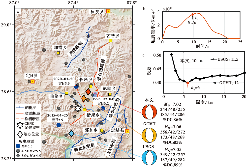
Fig. 1 The regional background of the Dingri earthquake.
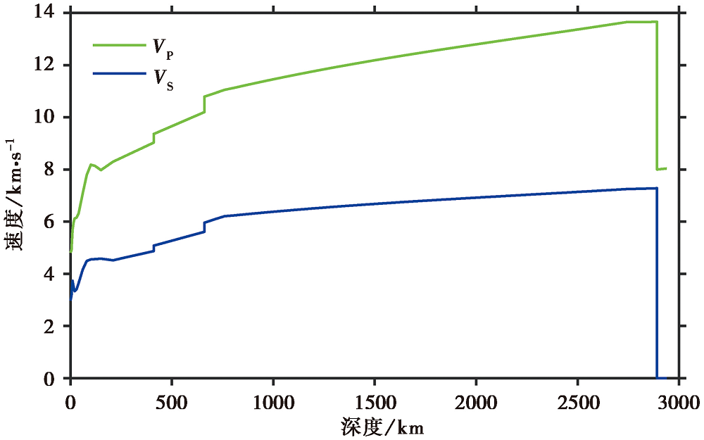
Fig. 2 Velocity model used for inversion.

Fig. 3 Distribution of deformation points and stations used in the joint inversion.
| 卫星传感器 | 轨道方向 | 主影像日期 | 辅影像日期 | 空间基线/m | 入射角/(°) | 飞行方位角/(°) |
|---|---|---|---|---|---|---|
| LT-1 | 升轨 | 2024-12-06 | 2025-01-07 | 667.7 | 32 | -13 |
Table 1 Information of SAR data
| 卫星传感器 | 轨道方向 | 主影像日期 | 辅影像日期 | 空间基线/m | 入射角/(°) | 飞行方位角/(°) |
|---|---|---|---|---|---|---|
| LT-1 | 升轨 | 2024-12-06 | 2025-01-07 | 667.7 | 32 | -13 |
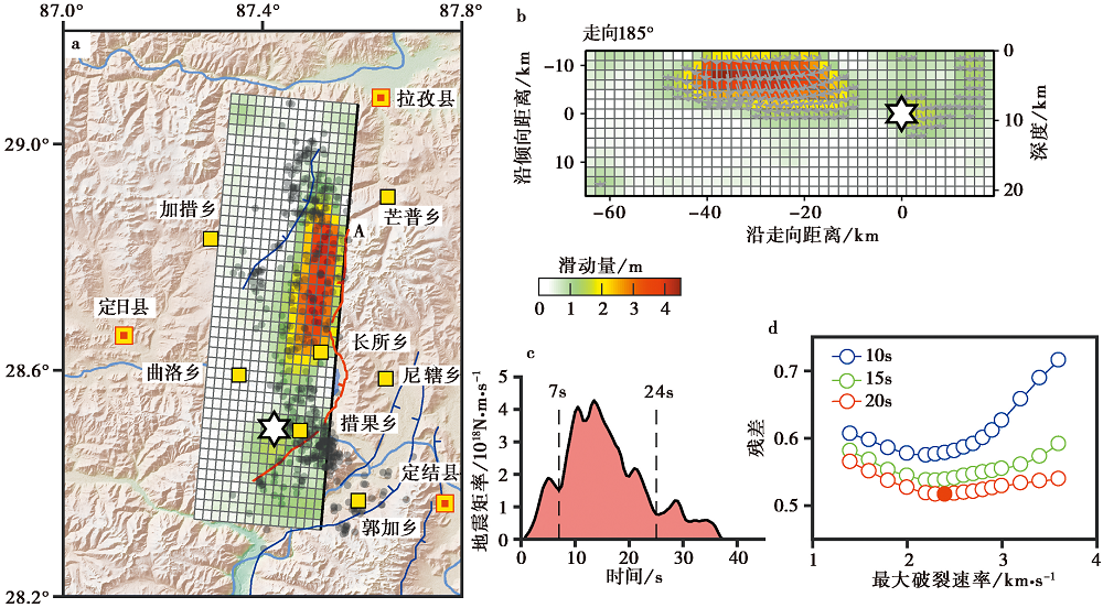
Fig. 4 The rupture results from single-fault joint inversion of the Dingri earthquake.
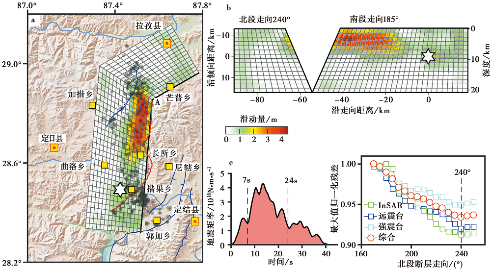
Fig. 5 The rupture results from double-fault joint inversion of the Dingri earthquake.
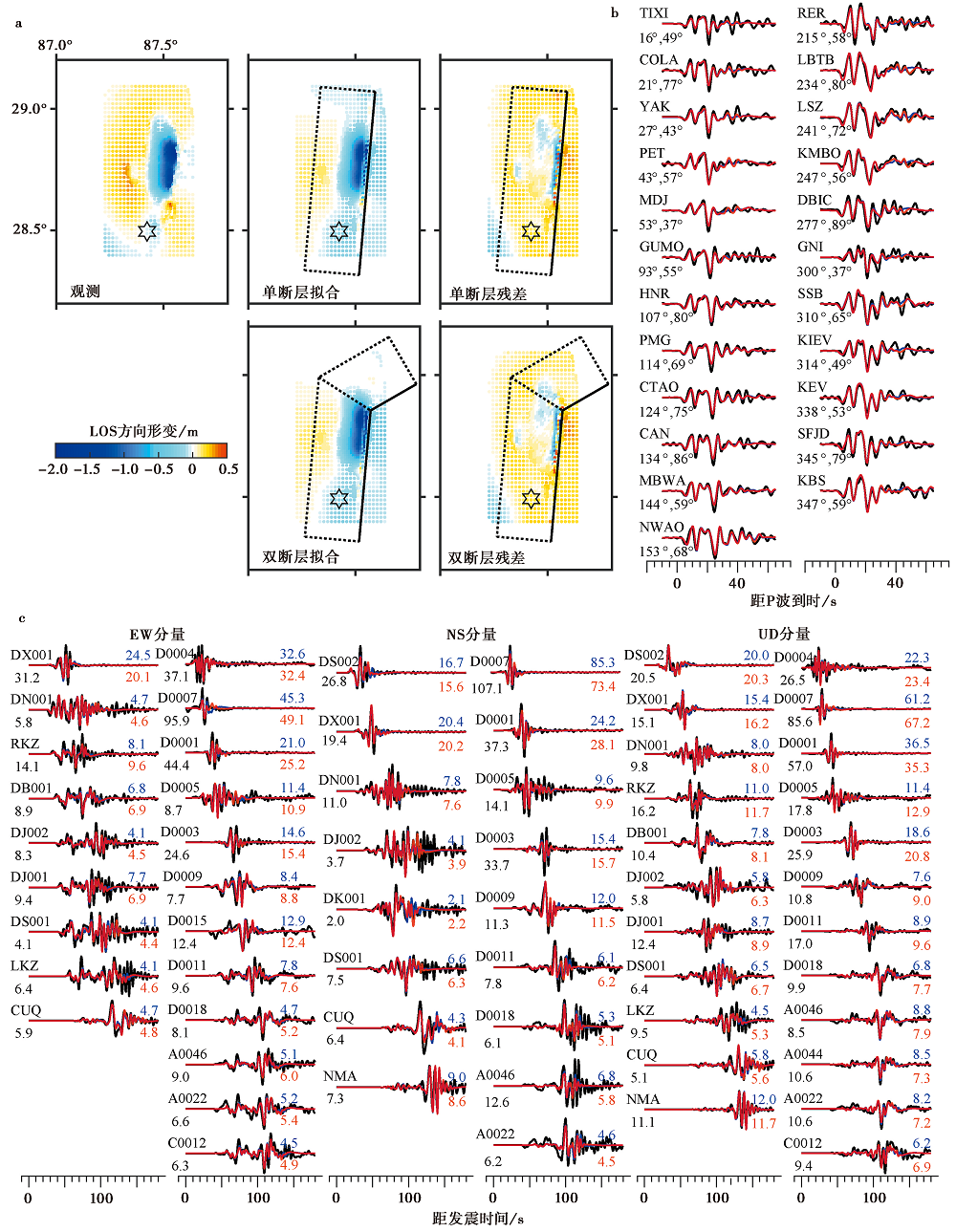
Fig. 6 Data fitting in the joint inversion.
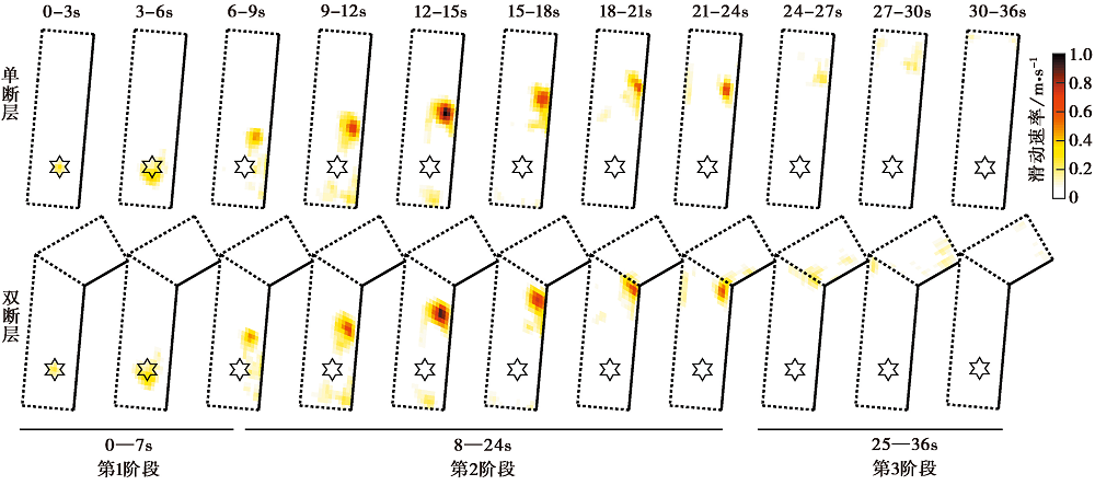
Fig. 7 Temporal snapshots of slip rate on the Dingri earthquake fault plane.
| [1] |
陈鲲, 杨婷, 王永哲, 等. 2025. 2025年1月7日西藏定日6.8级地震的快速产出参数[J]. 地震科学进展, 55(3): 164-171.
|
|
|
|
| [2] |
石峰, 梁明剑, 罗全星, 等. 2025. 2025年1月7日西藏定日6.8级地震发震构造与同震地表破裂特征[J]. 地震地质, 47(1): 1-15. doi: 10.3969/j.issn.0253-4967.2025.01.001.
|
|
DOI |
|
| [3] |
田婷婷. 2021. 申扎-定结裂谷南段丁木错断裂晚第四纪古地震事件研究[D]. 北京: 中国地质大学(北京).
|
|
|
|
| [4] |
田婷婷, 吴中海. 2023. 西藏申扎-定结裂谷南段丁木错正断层的最新史前大地震事件及其地震地质意义[J]. 地质论评, 69(S1): 53-55.
|
|
|
|
| [5] |
王楠, 李永生, 申文豪, 等. 2025. 2025年1月7日定日 MS6.8 地震震源机制InSAR反演及强地面运动快速模拟[J]. 武汉大学学报(信息科学版), 50(2): 404-411.
|
|
|
|
| [6] |
王永哲, 陈石, 陈鲲. 2021. InSAR 数据约束的 2020 年西藏定日 MW5.7 地震源模型及构造意义[J]. 地震, 41(1): 116-128.
|
|
|
|
| [7] |
徐心悦. 2019. 藏南申扎-定结断裂系卡达正断裂晚第四纪活动性及其环境效应[D]. 北京: 中国地震局地质研究所.
|
|
|
|
| [8] |
杨婷, 王世广, 房立华. 等. 2025. 2025年1月7日西藏定日 MS6.8 地震余震序列特征与发震构造[J]. 地球科学, 50(5): 1721-1732.
|
|
|
|
| [9] |
张进江, 丁林. 2003. 青藏高原EW向伸展及其地质意义[J]. 地质科学, 38(2): 179-189.
|
|
|
|
| [10] |
郑绪君, 张勇, 马强, 等. 2018. 基于强震动资料的破裂过程快速反演及其自动化的可行性[J]. 地球物理学报, 61(10): 4021-4036.
DOI |
|
|
|
| [11] |
|
| [12] |
|
| [13] |
|
| [14] |
|
| [15] |
|
| [16] |
|
| [17] |
|
| [1] | LI Yan, CHEN Jun-lei, LÜ Si-yu, WANG Yu-dong, FU Lei. THE STRESS FIELD INVERSION AND TRIGGER RELATIONSHIPS OF THE JINGGU EARTHQUAKE SEQUENCE [J]. SEISMOLOGY AND GEOLOGY, 2026, 48(2): 561-581. |
| [2] | WANG Xia, SONG Mei-qing, WU Hao-yu, LIANG Xiang-jun, LÜ Rui, GUO Wen-feng, ZHANG Na, LI Jin. STRESS FIELD IN SHANXI RIFT AND ITS DYNAMIC SIGNIFICANCE [J]. SEISMOLOGY AND GEOLOGY, 2026, 48(1): 257-277. |
| [3] | GUO Zhao-wu, LU Ren-qi, ZHANG Jin-yu, FANG Li-hua, LIU Guan-shen, WU Xi-yan, SUN Xiao, QI Shi-miao. THREE-DIMENSIONAL MODEL OF SEISMOGENIC FAULT AND SEISMIC ENVIRONMENT OF XIZANG DINGRI MS6.8 EARTHQUAKE OF JANUARY 7, 2025 [J]. SEISMOLOGY AND GEOLOGY, 2025, 47(3): 671-688. |
| [4] | GAO Yang, WU Zhong-hai, HAN Shuai, TIAN Ting-ting. LATE QUATERNARY THROW RATE OF THE SEISMOGENIC FAULT(DENGMECUO FAULT)OF THE 2025 MS6.8 DINGRI EARTHQUAKE IN SHIGATSE [J]. SEISMOLOGY AND GEOLOGY, 2025, 47(3): 689-706. |
| [5] | WANG Duo, CHEN Li-chun, LI Yan-bao, WANG Hu, JIA Yong-shun, GAO Yin-yi, XUE Ke-yi. LATE QUATERNARY ACTIVITY OF THE XIETONGMEN TO DENGMECUO SEGMENT ALONG THE XAINZA-DINGGYE RIFT IN SOUTHERN QINGHAI-XIZANG PLATEAU [J]. SEISMOLOGY AND GEOLOGY, 2025, 47(3): 718-733. |
| [6] | QIAO Jun-xiang, SHI Feng, LI An, LI Tao, ZHANG Da, WANG Xin, Gesangdanzhen, SUN Hao-yue. COSEISMIC SURFACE RUPTURE OF THE MS6.8 DINGRI EARTHQUAKE IN XIZANG, CHINA, BASED ON GF IMAGERY INTERPRETATION [J]. SEISMOLOGY AND GEOLOGY, 2025, 47(3): 789-805. |
| [7] | WU Xiao-fei, MENG Ling-yuan. COMPARISON OF THE CHARACTERISTICS OF EARTHQUAKE SEQUENCE AND INTENSITY OF THE JANUARY 7, 2025 MS6.8 DINGRI EARTHQUAKE IN XIZANG [J]. SEISMOLOGY AND GEOLOGY, 2025, 47(3): 869-880. |
| [8] | YIN Xiao-fei, QIANG Sheng-yin, ZHANG Wei, SHAO Zhi-gang, WANG Wu-xing, YUAN Xiao-xiang, LI Yong-sheng, LIU Hao. RESEARCH ON GROUND MOTION SIMULATION OF THE DINGRI MS6.8 EARTHQUAKE IN XIZANG BASED ON DIFFERENT SOURCE MODELS [J]. SEISMOLOGY AND GEOLOGY, 2025, 47(3): 897-916. |
| [9] | JI Zhi-wei, YU Hou-yun, LI Zong-chao, JU Chang-hui, SUN Yao-chong, ZHANG Yong-xian, CHEN Xiao-fei. PRELIMINARY SIMULATION OF LONG-PERIOD GROUND MOTION OF THE DINGRI MS6.8 EARTHQUAKE ON JANUARY 7, 2025 [J]. SEISMOLOGY AND GEOLOGY, 2025, 47(3): 917-931. |
| [10] | DU Hao-guo, ZUO Xiao-qing, LIN Xu-chuan, XIAO Ben-fu, LU Yong-kun, HE Shi-fang, ZHANG Fang-hao, YUAN Xiao-xiang, TAO Tian-yan, YE Yang, DENG Shu-rong, ZHAO Zheng-xian, XU Jun-zu, BAI Xian-fu, ZHANG Yuan-shuo, ZHANG Lu-lu. TEXTURE FEATURE DAMAGE DETECTION OF SINGLE BUILD-ING BASED ON DRONE IMAGES AFTER EARTHQUAKE: A CASE STUDY OF 2025 DINGRI MS6.8 EARTHQUAKE IN XIZANG, CHINA [J]. SEISMOLOGY AND GEOLOGY, 2025, 47(3): 949-968. |
| [11] | ZHANG Li-feng, ZHONG Mei-jiao, PAN Yu-hang, GUO Ying-xia, SUN Xi-hao, ZHANG Yuan-sheng. STUDY ON THERMAL INFRARED ANOMALIES OF THE 2025 DINGRI MS6.8 EARTHQUAKE AND SEVERAL EARTHQUAKE CASES IN SOUTHERN XIZANG [J]. SEISMOLOGY AND GEOLOGY, 2025, 47(3): 984-998. |
| [12] | LI Jin, DENG Ming-wen, ZHANG Zhi-guang, SUN Ye-jun, YAO Yuan, XU Kai-chi. PRELIMINARY STUDY ON THE SEISMOGENIC STRUCTURE OF THE 2024 M5 EARTHQUAKE SWARM IN YULI, TARIM BASIN [J]. SEISMOLOGY AND GEOLOGY, 2025, 47(2): 463-487. |
| [13] | SHI Feng, LIANG Ming-jian, LUO Quan-xing, QIAO Jun-xiang, ZHANG Da, WANG Xin, YI Wen-xing, ZHANG Jia-wei, ZHANG Ying-feng, ZHANG Hui-ping, LI Tao, LI An. SEISMOGENIC FAULT AND COSEISMIC SURFACE DEFORMATION OF THE DINGRI MS6.8 EARTHQUAKE IN XIZANG, CHINA [J]. SEISMOLOGY AND GEOLOGY, 2025, 47(1): 1-15. |
| [14] | ZOU Jun-jie, SHAO Zhi-gang, HE Hong-lin, GAO Lu, XU Yue-yi, DOU Ai-xia, LIANG Ze-yu. SURFACE RUPTURE INTERPRETATION AND BUILDING DAMAGE ASSESSMENT OF XIZANG DINGRI MS6.8 EARTHQUAKE ON JANUARY 7, 2025 [J]. SEISMOLOGY AND GEOLOGY, 2025, 47(1): 16-35. |
| [15] | YANG Jian-wen, JIN Ming-pei, YE Beng, LI Zhen-ling, LI Qing. SOURCE RUPTURE MECHANISM AND STRESS CHANGES TO THE ADJACENT AREA OF JANUARY 7, 2025, MS6.8 DINGRI EARTHQUAKE, XIZANG, CHINA [J]. SEISMOLOGY AND GEOLOGY, 2025, 47(1): 36-48. |
| Viewed | ||||||
|
Full text |
|
|||||
|
Abstract |
|
|||||
Copyright © SEISMOLOGY AND GEOLOGY, All Rights Reserved.
Tel: 010-62009049/9063 E-mail: dzdz@ies.ac.cn
Powered by Beijing Magtech Co., Ltd.