
SEISMOLOGY AND GEOLOGY ›› 2025, Vol. 47 ›› Issue (5): 1364-1381.DOI: 10.3969/j.issn.0253-4967.2025.05.20240111
• Research paper • Previous Articles Next Articles
THE S-WAVE VELOCITY STRUCTURE OF THE TENGCHONG-BAOSHAN REGION FROM JOINT INVERSION OF RECEIVER FUNCTION AND RAYLEIGH WAVE PHASE VELOCITY
ZHANG Tian-ji( ), QIN Min, DANG Wen-jie, JIN Ming-pei, LI Feng-ying, YANG Li-wei
- Yunnan Earthquake Agency, Kunming 650224, Yunnan, China
-
Received:2024-09-09Revised:2024-12-24Online:2025-10-20Published:2025-11-11
接收函数与瑞利波相速度联合反演腾冲-保山地区的S波速度结构
张天继(), 秦敏, 党文杰, 金明培, 李凤英, 杨黎薇
- 云南省地震局, 昆明 650224
-
作者简介:张天继, 女, 1991年生, 2017年于云南大学获固体地球物理学硕士学位, 工程师, 主要从事地震学和地球深部结构研究, E-mail: 1656602356@qq.com。
-
基金资助:云南省地震局科技人员传帮带培养项目(CX3-2024-01); 云南省地震局科技专项(2025ZX01); 云南省地震科技创新团队(CXTD202501)
Cite this article
ZHANG Tian-ji, QIN Min, DANG Wen-jie, JIN Ming-pei, LI Feng-ying, YANG Li-wei. THE S-WAVE VELOCITY STRUCTURE OF THE TENGCHONG-BAOSHAN REGION FROM JOINT INVERSION OF RECEIVER FUNCTION AND RAYLEIGH WAVE PHASE VELOCITY[J]. SEISMOLOGY AND GEOLOGY, 2025, 47(5): 1364-1381.
张天继, 秦敏, 党文杰, 金明培, 李凤英, 杨黎薇. 接收函数与瑞利波相速度联合反演腾冲-保山地区的S波速度结构[J]. 地震地质, 2025, 47(5): 1364-1381.
share this article
Add to citation manager EndNote|Ris|BibTeX
URL: https://www.dzdz.ac.cn/EN/10.3969/j.issn.0253-4967.2025.05.20240111
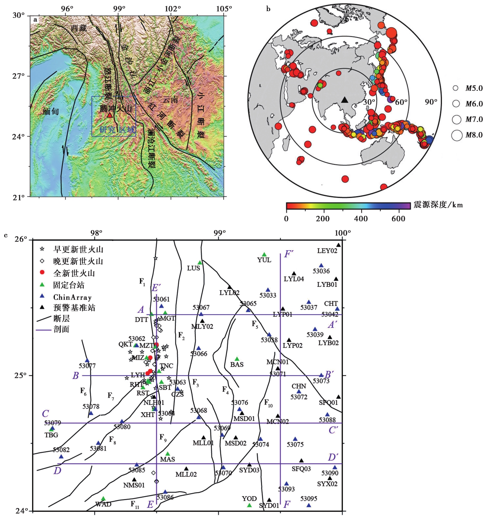
Fig. 1 Maps showing tectonic setting, teleseismic events and station locations.
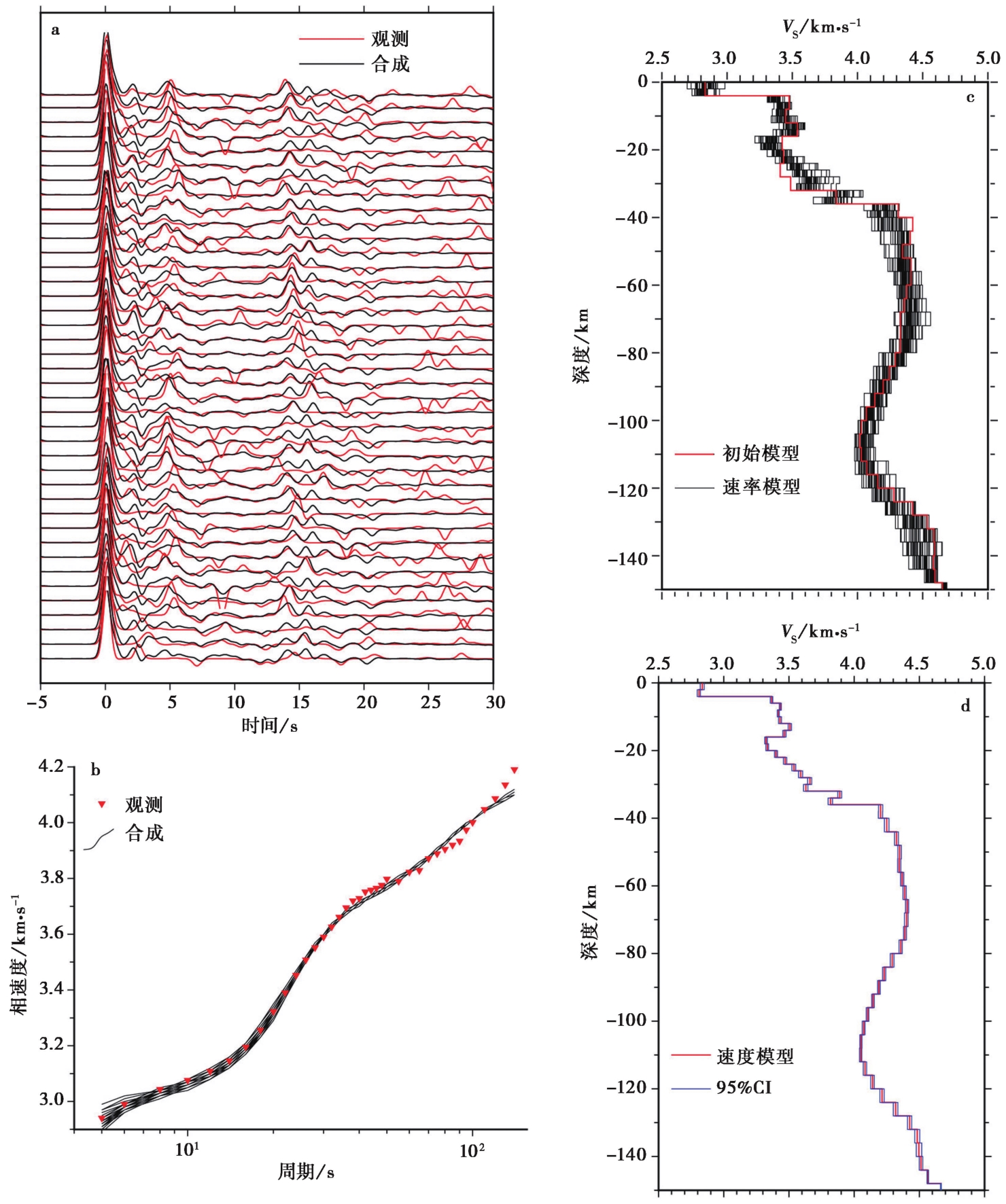
Fig. 3 The second-step joint inversion for station MLL01.
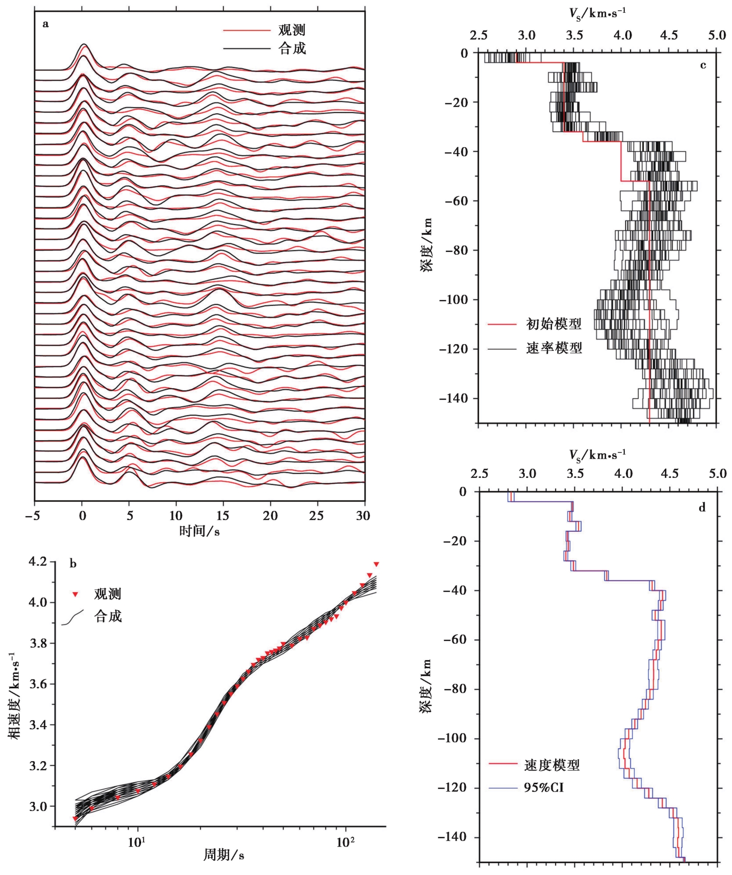
Fig. 2 The first-step joint inversion for station MLL01.
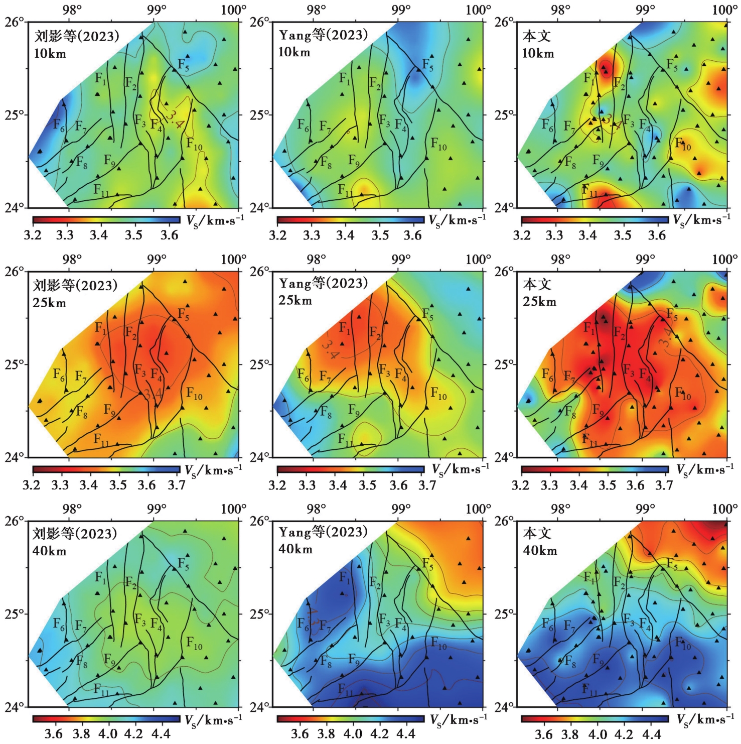
Fig. 6 Comparisons of the model in this study with that of Liu et al.(2023)and Yang et al.(2023).
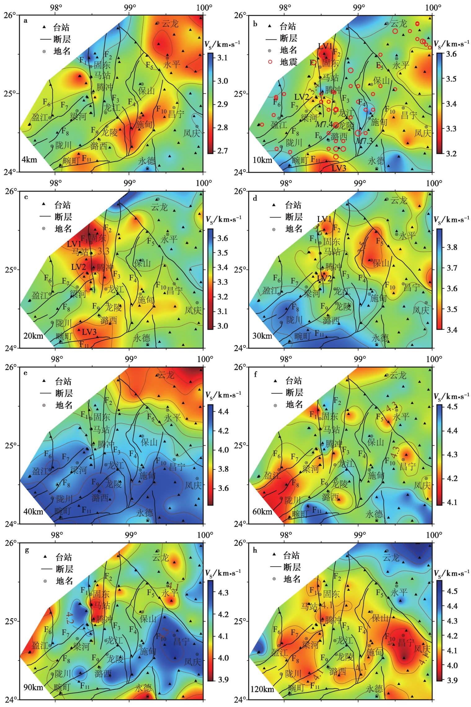
Fig. 4 Distribution of S-wave velocity at different depths.
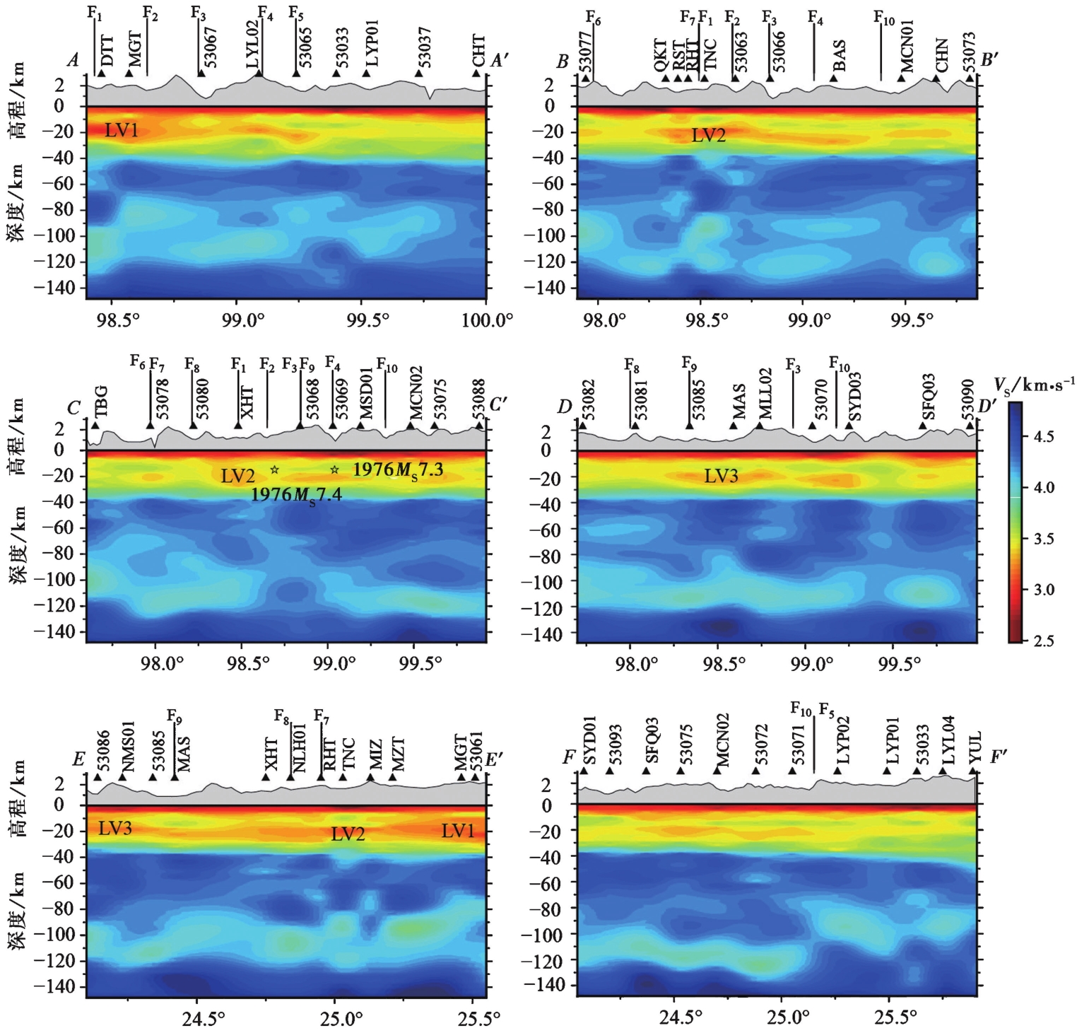
Fig. 5 Distribution of S-wave velocity at vertical profiles.
| [1] |
曹令敏, 胥颐, 吴时国. 2013. 腾冲地区地壳速度结构的有限差分成像[J]. 地球物理学报, 56(4): 1159-1167.
|
|
|
|
| [2] |
段毅, 危自根, 杨小林, 等. 2019. 腾冲火山结构研究进展和展望[J]. 地球物理学进展, 34(4): 1288-1297.
|
|
|
|
| [3] |
韩新民, 周瑞琦, 周真恒. 1996. 腾冲火山地质研究述评[J]. 地震地磁观测与研究, 17(6): 20-30.
|
|
|
|
| [4] |
胡家富, 丛连理, 苏有锦, 等. 2003. 云南及周边地区Lg尾波Q值的分布特征[J]. 地球物理学报, 46(6): 809-813.
|
|
|
|
| [5] |
姜朝松. 1998. 腾冲地区新生代火山活动分期[J]. 地震研究, 21(4): 320-329.
|
|
|
|
| [6] |
姜枚, 谭捍东, 张聿文, 等. 2012. 云南腾冲火山构造区马站-固东岩浆囊的地球物理模式[J]. 地球学报, 33(5): 731-739.
|
|
|
|
| [7] |
李大明, 李齐, 陈文寄. 2000. 腾冲火山区上新世以来的火山活动[J]. 岩石学报, 16(3): 362-370.
|
|
|
|
| [8] |
李辉, 彭松柏, 乔卫涛, 等. 2011. 根据多时相夜间MODIS LST推断的腾冲地区新生代火山岩岩浆囊分布与活动特征[J]. 岩石学报, 27(10): 2873-2882.
|
|
|
|
| [9] |
李琳琳, 王书兵, 刘建辉, 等. 2015. 滇西腾冲曲石地区中更新世火山岩年龄及成因: SHRIMP锆石U-Pb定年和Hf同位素约束[J]. 岩石学报, 31(9): 2609-2619.
|
|
|
|
| [10] |
刘影, 于子叶, 张智奇, 等. 2023. 基于密集流动台阵构建的川滇地区高分辨率公共速度模型2.0版本[J]. 中国科学(D辑), 53(10): 2407-2424.
|
|
|
|
| [11] |
穆治国, 佟伟, Curtis G H. 1987. 腾冲火山活动的时代和岩浆来源问题[J]. 地球物理学报, 30(3): 261-270.
|
|
|
|
| [12] |
上官志冠, 白春华, 孙明良. 2000. 腾冲热海地区现代幔源岩浆气体释放特征[J]. 中国科学(D辑), 30(4): 407-414.
|
|
|
|
| [13] |
杨晓涛, 胥颐, 刘建华, 等. 2011. 腾冲火山区的地震层析成像及其构造意义[J]. 地球物理学报, 54(8): 2050-2059.
|
|
|
|
| [14] |
张龙, 胡毅力, 秦敏, 等. 2015. 云南腾冲火山区地壳及岩石圈厚度研究[J]. 地球物理学报, 58(5): 1622-1633.
|
|
|
|
| [15] |
张天继, 李秋凤, 李凤英, 等. 2024. 利用H-κ-c方法研究腾冲火山区的地壳厚度与泊松比[J]. 地震地质, 46(5): 1048-1065. doi: 10.3969/j.issn.0253-4967.2024.05.004.
|
|
|
|
| [16] |
赵慈平, 冉华, 陈坤华. 2006. 由相对地热梯度推断的腾冲火山区现存岩浆囊[J]. 岩石学报, 22(6): 1517-1528.
|
|
|
|
| [17] |
赵慈平, 冉华, 王云. 2012. 腾冲火山区的现代幔源氦释放: 构造和岩浆活动意义[J]. 岩石学报, 28(4): 1189-1204.
|
|
|
|
| [18] |
赵勇伟, 樊祺诚. 2010. 腾冲马鞍山、 打鹰山、 黑空山火山岩浆来源与演化[J]. 岩石学报, 26(4): 1133-1140.
|
|
|
|
| [19] |
|
| [20] |
|
| [21] |
|
| [22] |
DOI URL |
| [23] |
|
| [24] |
|
| [25] |
|
| [26] |
|
| [27] |
|
| [28] |
|
| [29] |
|
| [30] |
DOI |
| [31] |
|
| [32] |
|
| [33] |
DOI URL |
| [34] |
DOI URL |
| [35] |
|
| [36] |
DOI URL |
| [37] |
|
| [38] |
|
| [39] |
|
| [40] |
|
| [41] |
|
| [42] |
|
| [1] | LI Ruo-hao, LEI Jian-she, SONG Xiao-yan. 3-D CRUSTAL S-WAVE VELOCITY STRUCTURE IN AND AROUND THE DATONG VOLCANIC GROUP: CONSTRAINTS FROM DIRECT TOMOGRAPHIC IMAGING OF AMBIENT-NOISE SURFACE WAVES [J]. SEISMOLOGY AND GEOLOGY, 2025, 47(4): 1090-1112. |
| [2] | YANG Jian-wen, JIN Ming-pei, YE Beng, CHA Wen-jian, HEI He-tang. THREE-DIMENSIONAL VELOCITY STRUCTURE AND SEI-SMOGENIC ENVIRONMENT IN THE MIDDLE AND UPPER CRUST OF NORTHWEST YUNNAN FROM AMBIENT NOISE TOMOGRAPHY [J]. SEISMOLOGY AND GEOLOGY, 2025, 47(4): 1113-1131. |
| [3] | JI Yu, ZHANG Guang-wei, REN Jun-jie, HE Jing, WANG Xiao-wei. HIGH-RESOLUTION S-WAVE VELOCITY STRUCTURE OF BEIJING AREA USING AMBIENT NOISE TOMOGRAPHY [J]. SEISMOLOGY AND GEOLOGY, 2025, 47(1): 306-324. |
| [4] | FENG Ce, SONG Xiu-qing, WANG Ren-tao, LIU Hao-lan. S-WAVE VELOCITY STRUCTURE IN SHANGHAI AND ADJACENT AREAS BASED ON AMBIENT NOISE TOMOGRAPHY [J]. SEISMOLOGY AND GEOLOGY, 2024, 46(6): 1374-1390. |
| [5] | ZHANG Tian-ji, LI Qiu-feng, LI Feng-ying, ZHONG Yu-sheng, DUAN Hong-jie. THE STUDY OF CRUSTAL THICKNESS AND POISSON'S RATIO IN TENGCHONG VOLCANO AREA BY H-к-c METHOD [J]. SEISMOLOGY AND GEOLOGY, 2024, 46(5): 1048-1065. |
| [6] | XIONG Guo-hua, JI Ling-yun, LIU Chuan-jin. ANALYSING THE SURFACE DEFORMATION AND PRESENT-DAY MAGMA ACTIVITY OF CHANGBAISHAN-TIANCHI VOLCANO FROM 2015 TO 2022 WITH INSAR TECHNOLOGY [J]. SEISMOLOGY AND GEOLOGY, 2023, 45(6): 1309-1327. |
| [7] | YANG Jian-wen, JIN Ming-pei, CHA Wen-jian, ZHANG Tian-ji, YE Beng. CRUSTAL S-WAVE VELOCITY STRUCTURE BENEATH THE XIAO-JIANG FAULT ZONE AND ADJACENT REGIONS REVEALED BY TWO-STEP INVERSION METHOD OF RECEIVER FUNCTIONS [J]. SEISMOLOGY AND GEOLOGY, 2023, 45(1): 190-207. |
| [8] | SONG Ting, SHEN Xu-zhang, MEI Xiu-ping, JIAO Yu-yuan, LI Min-juan, SU Xiao-yun, JI Wan-jing. CONSTRAINING MOHO CHARACTERISTICS IN THE NORTH-EASTERN MARGIN OF TIBET PLATEAU WITH FREQUENCY-DEPENDENCE OF RECEIVER FUNCTION [J]. SEISMOLOGY AND GEOLOGY, 2022, 44(5): 1290-1312. |
| [9] | PAN Ji-shun, LI Peng-hui, DUAN Yong-hong, ZHAO Yan-na, PENG Yi-cong, SUN Kai-xuan. STUDY ON THE CRUSTAL STRUCTURE OF THE CENTRAL AND WESTERN PART OF THE NORTH CHINA CRATON [J]. SEISMOLOGY AND EGOLOGY, 2021, 43(5): 1269-1291. |
| [10] | KONG Xiang-yan, WU Jian-ping, FANG Li-hua, CAI Yan, FAN Li-ping, WANG Wei-lai. JOINT INVERSION OF SURFACE WAVE DISPERSION AND RECEIVER FUNCTIONS FOR CRUSTAL AND UPPERMOST MANTLE STRUCTURE BENEATH CHINESE TIENSHAN AND ITS ADJACENT AREAS [J]. SEISMOLOGY AND GEOLOGY, 2020, 42(4): 844-865. |
| [11] | GAO Jian, YANG Yi-hai, HUANG Shi-yuan, YANG Cong, ZHANG Yuan-sheng, LIU Cun-xi, LI Shao-rui, HUA Qian. CRUSTAL ANISOTROPY AND ITS TECTONIC IMPLICATIONS IN THE CHONGQING REGION [J]. SEISMOLOGY AND GEOLOGY, 2020, 42(1): 147-162. |
| [12] | TANG Ming-shuai, WANG Hai-tao, WEI Yun-yun, LI Yan-yong, GE Can, WANG Qiong, SU Jin-bo, WEI Bin. POISSON'S RATIO VARIATIONS OF CRUSTAL MEDIA BEFORE AND AFTER XINYUAN-HEJING MS6.6 EARTHQUAKE IN 2012 [J]. SEISMOLOGY AND GEOLOGY, 2019, 41(5): 1123-1135. |
| [13] | FENG Hong-wu, YAN Wen-hua, YAN Shan, GUO Ying-xia, HUI Shao-xing, CHANG Cheng. JOINT INVERSION OF AMBIENT NOISE AND SURFACE WAVE FOR S-WAVE VELOCITY OF THE CRUST AND UPPERMOST MANTLE BENEATH WEIHE BASIN AND ITS ADJACENT AREA [J]. SEISMOLOGY AND GEOLOGY, 2019, 41(5): 1185-1205. |
| [14] | XIE Hui, MA He-qing, JIAO Ming-ruo, MA Xiao-jun, ZHANG Nan, LI-Qing-mei. THE INVERSION OF S-WAVE VELOCITY STRUCTURE IN NINGXIA AND ITS ADJACENT AREA USING BACKGROUND NOISE IMAGING TECHNOLOGY [J]. SEISMOLOGY AND GEOLOGY, 2017, 39(3): 605-622. |
| [15] | LUO Jia-hong, MA Wen-tao. A PRELIMINARY STUDY ON UPPER CRUSTAL VELOCITY STRUCTURE IN THE THREE GORGES RESERVOIR AREA [J]. SEISMOLOGY AND GEOLOGY, 2016, 38(2): 329-341. |
| Viewed | ||||||
|
Full text |
|
|||||
|
Abstract |
|
|||||
Copyright © SEISMOLOGY AND GEOLOGY, All Rights Reserved.
Tel: 010-62009049/9063 E-mail: dzdz@ies.ac.cn
Powered by Beijing Magtech Co., Ltd.