
SEISMOLOGY AND GEOLOGY ›› 2025, Vol. 47 ›› Issue (5): 1382-1395.DOI: 10.3969/j.issn.0253-4967.2025.05.20240027
Previous Articles Next Articles
COSEISMIC DEFORMATION FIELD AND SLIP MODELS OF JANUARY 23, 2024 MS7.1 WUSHI EARTHQUAKE, XINJIANG, CHINA
YANG Jian-wen1,2)( ), JIN Ming-pei1,2),*(), LI Qing1,2), LI Zhen-ling1), YE Beng1,2), LI Jian1,2), ZHANG Ying-feng3)
- 1)Yunnan Earthquake Agency, Kunming 650224, China
2)Field Scientific Observation and Research Station on Crustal Tectonic Activities in Northwest Yunnan, Dali 671000, China
3)State Key Laboratory of Earthquake Dynamics and Forecasting, Institute of Geology, China Earthquake Administration, Beijing 100029, China
-
Received:2024-03-12Online:2025-10-20Published:2025-11-11
2024年1月23日新疆乌什 MS7.1 地震同震形变场和震源滑动模型反演
杨建文1,2)(), 金明培1,2),*(), 李庆1,2), 黎朕灵1), 叶泵1,2), 李见1,2), 张迎峰3)
- 1)云南省地震局, 昆明 650224
2)云南大理滇西北地壳构造活动野外科学观测研究站, 大理 671000
3)中国地震局地质研究所, 地震动力学国家重点实验室, 北京 100029
-
通讯作者:金明培, 男, 1969年生, 正研级高级工程师, 主要从事接收函数、 震源模型等研究, E-mail:jmp69@263.net 。 -
作者简介:杨建文, 男, 1989年生, 2014年于昆明理工大学获测绘工程专业硕士学位, 高级工程师, 主要从事InSAR数据处理和断层参数反演研究工作, E-mail: 928547602@qq.com。
-
基金资助:云南省地震科技创新团队(CXTD202506); 中国地震局地震科技星火计划项目(XH23034YA); 云南省地震局地震科技专项基金(2023ZX01)
Cite this article
YANG Jian-wen, JIN Ming-pei, LI Qing, LI Zhen-ling, YE Beng, LI Jian, ZHANG Ying-feng. COSEISMIC DEFORMATION FIELD AND SLIP MODELS OF JANUARY 23, 2024 MS7.1 WUSHI EARTHQUAKE, XINJIANG, CHINA[J]. SEISMOLOGY AND GEOLOGY, 2025, 47(5): 1382-1395.
杨建文, 金明培, 李庆, 黎朕灵, 叶泵, 李见, 张迎峰. 2024年1月23日新疆乌什 MS7.1 地震同震形变场和震源滑动模型反演[J]. 地震地质, 2025, 47(5): 1382-1395.
share this article
Add to citation manager EndNote|Ris|BibTeX
URL: https://www.dzdz.ac.cn/EN/10.3969/j.issn.0253-4967.2025.05.20240027
| 模式 | 轨道号 | 框架(Frame) | 成像日期 | 时间间隔/d | |
|---|---|---|---|---|---|
| 主影像(震前) | 辅影像(震后) | ||||
| 升轨 | 56 | 128 | 2024-01-14 | 2024-01-26 | 12 |
| 133 | 2024-01-14 | 2024-01-26 | 12 | ||
| 降轨 | 34 | 454 | 2024-01-13 | 2024-01-25 | 12 |
Table1 Basic parameters of Sentinel-1A satellite image of the Wushi earthquake
| 模式 | 轨道号 | 框架(Frame) | 成像日期 | 时间间隔/d | |
|---|---|---|---|---|---|
| 主影像(震前) | 辅影像(震后) | ||||
| 升轨 | 56 | 128 | 2024-01-14 | 2024-01-26 | 12 |
| 133 | 2024-01-14 | 2024-01-26 | 12 | ||
| 降轨 | 34 | 454 | 2024-01-13 | 2024-01-25 | 12 |
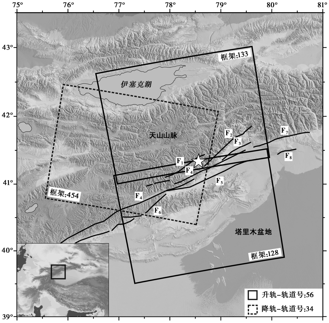
Fig. 1 Regional tectonic setting of the Wushi earthquake.
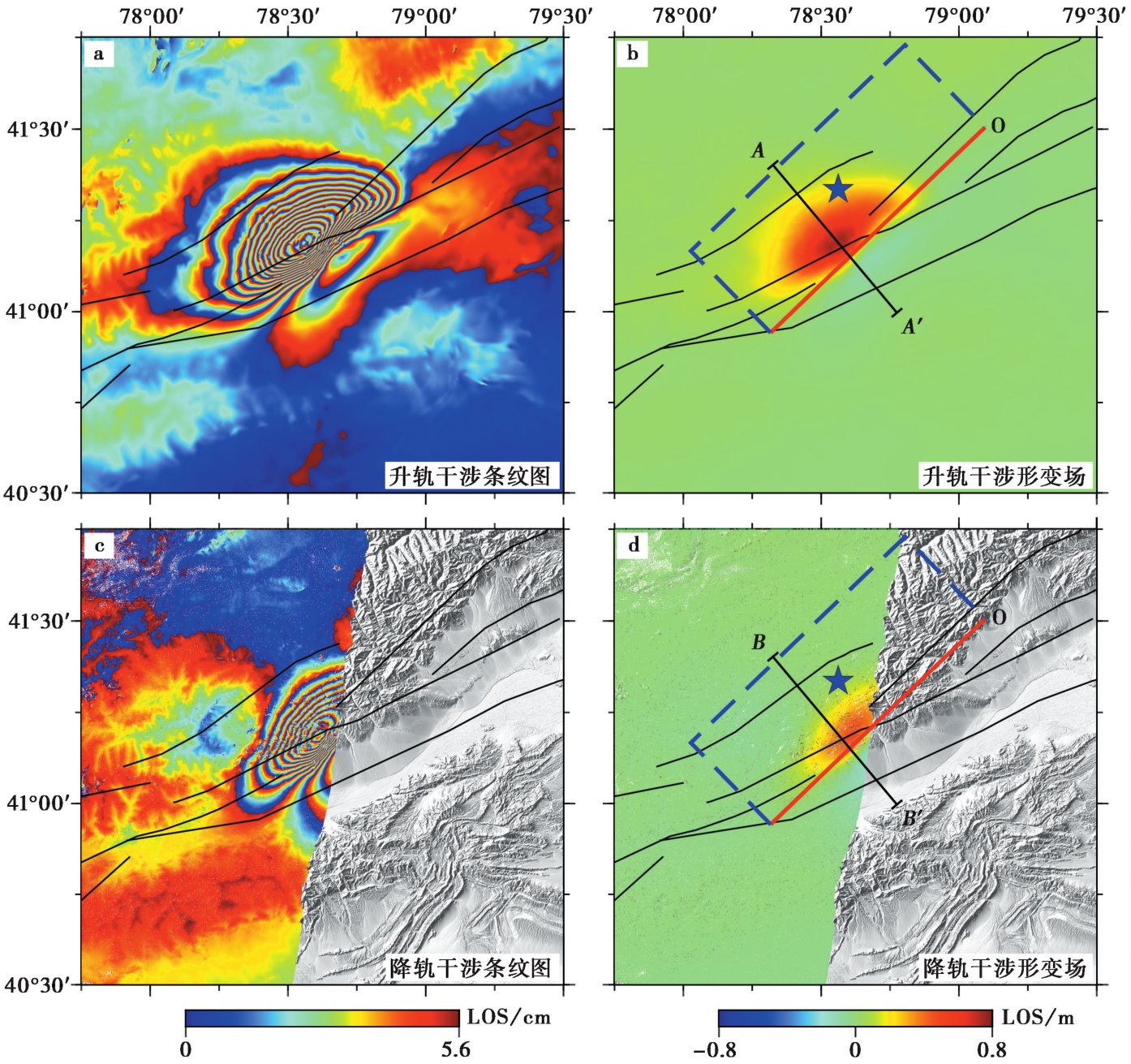
Fig. 2 InSAR ascending and descending coseismic deformation fields of the Wushi earthquake.
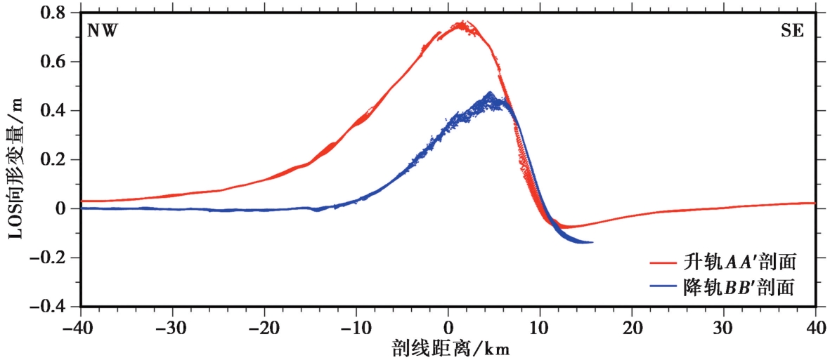
Fig. 3 InSAR ascending and descending coseismic deformation profile of the Wushi earthquake.
| 分层/km | VP/km·s-1 | VS/km·s-1 | 密度/kg·m-3 |
|---|---|---|---|
| 0~5 | 4.6480 | 2.7520 | 2600 |
| 5~10 | 5.5410 | 3.2730 | 2700 |
| 10~15 | 5.8320 | 3.4150 | 2700 |
| 15~20 | 6.1340 | 3.5520 | 2850 |
| 20~30 | 6.2270 | 3.6310 | 2850 |
| 30~40 | 6.3990 | 3.7660 | 3000 |
| 40~60 | 6.5300 | 3.8480 | 3000 |
| ≥60 | 7.5510 | 4.3230 | 3100 |
Table2 Crustal velocity model used for inversion
| 分层/km | VP/km·s-1 | VS/km·s-1 | 密度/kg·m-3 |
|---|---|---|---|
| 0~5 | 4.6480 | 2.7520 | 2600 |
| 5~10 | 5.5410 | 3.2730 | 2700 |
| 10~15 | 5.8320 | 3.4150 | 2700 |
| 15~20 | 6.1340 | 3.5520 | 2850 |
| 20~30 | 6.2270 | 3.6310 | 2850 |
| 30~40 | 6.3990 | 3.7660 | 3000 |
| 40~60 | 6.5300 | 3.8480 | 3000 |
| ≥60 | 7.5510 | 4.3230 | 3100 |
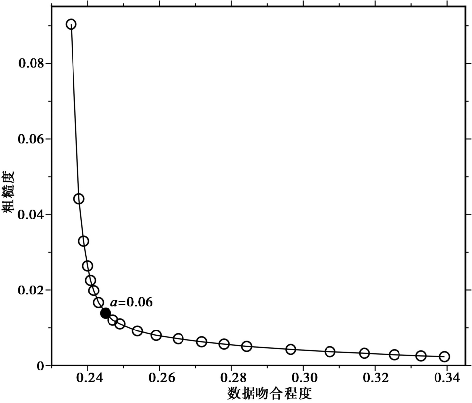
Fig. 4 Compromise curve between roughness of dislocation model and misfit of data.
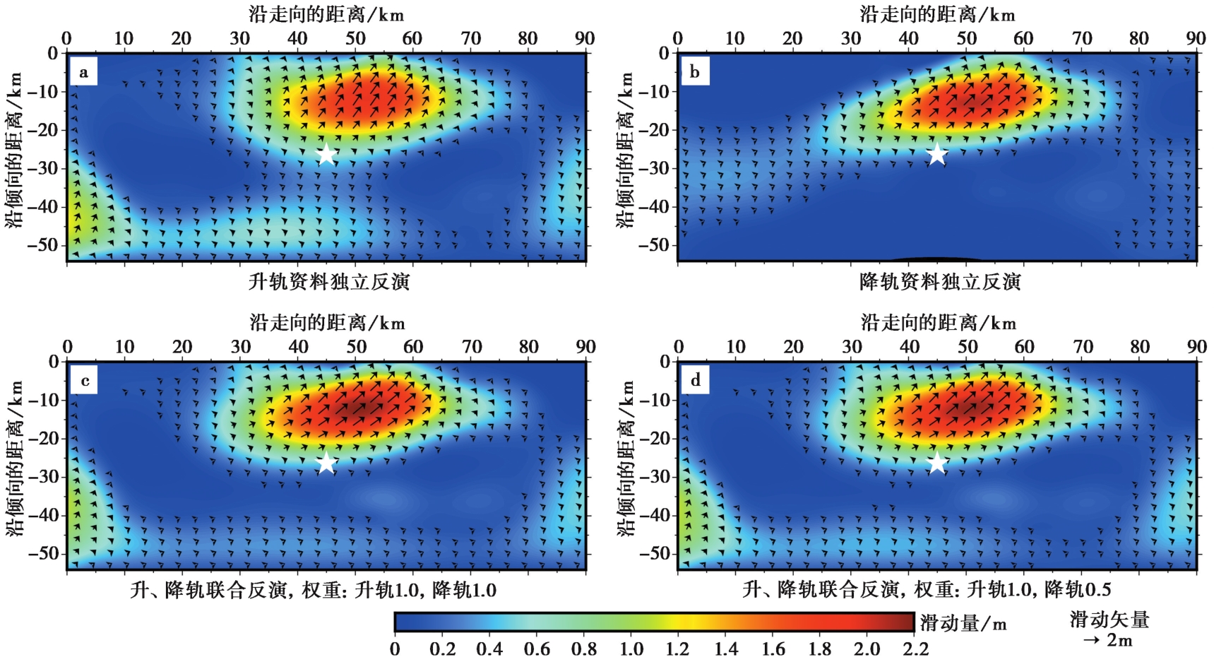
Fig. 5 Slip models based on InSAR ascending and descending deformation data independently and joint inversion respectively.
| 参数比较 | 升轨 | 降轨 | 升轨(权重1.0)+ 降轨(权重1.0) | 升轨(权重1.0)+ 降轨(权重0.5) |
|---|---|---|---|---|
| MW | 7.10 | 6.99 | 7.09 | 7.09 |
| 数-模相关系数 | 0.98 | 0.94 | 0.97 | 0.97 |
| 平均滑动/m | 0.39 | 0.26 | 0.37 | 0.37 |
| 最大滑动/m | 1.93 | 2.05 | 2.15 | 2.12 |
| 最大滑动所在深度/km | 8.04 | 10.34 | 10.34 | 10.34 |
| 最大滑动所在位置 | 41.22°N,78.58°E | 41.25°N,78.59°E | 41.25°N,78.59°E | 41.25°N,78.59°E |
| 平均滑动角/(°) | 45.62 | 35.68 | 37.65 | 38.39 |
| 平均应力降/MPa | 0.84 | 0.83 | 0.90 | 0.95 |
| 最大应力降/MPa | 5.39 | 5.42 | 5.87 | 5.28 |
Table3 Comparison of slip model parameters by different inversion methods based on the same fault plane parameters
| 参数比较 | 升轨 | 降轨 | 升轨(权重1.0)+ 降轨(权重1.0) | 升轨(权重1.0)+ 降轨(权重0.5) |
|---|---|---|---|---|
| MW | 7.10 | 6.99 | 7.09 | 7.09 |
| 数-模相关系数 | 0.98 | 0.94 | 0.97 | 0.97 |
| 平均滑动/m | 0.39 | 0.26 | 0.37 | 0.37 |
| 最大滑动/m | 1.93 | 2.05 | 2.15 | 2.12 |
| 最大滑动所在深度/km | 8.04 | 10.34 | 10.34 | 10.34 |
| 最大滑动所在位置 | 41.22°N,78.58°E | 41.25°N,78.59°E | 41.25°N,78.59°E | 41.25°N,78.59°E |
| 平均滑动角/(°) | 45.62 | 35.68 | 37.65 | 38.39 |
| 平均应力降/MPa | 0.84 | 0.83 | 0.90 | 0.95 |
| 最大应力降/MPa | 5.39 | 5.42 | 5.87 | 5.28 |
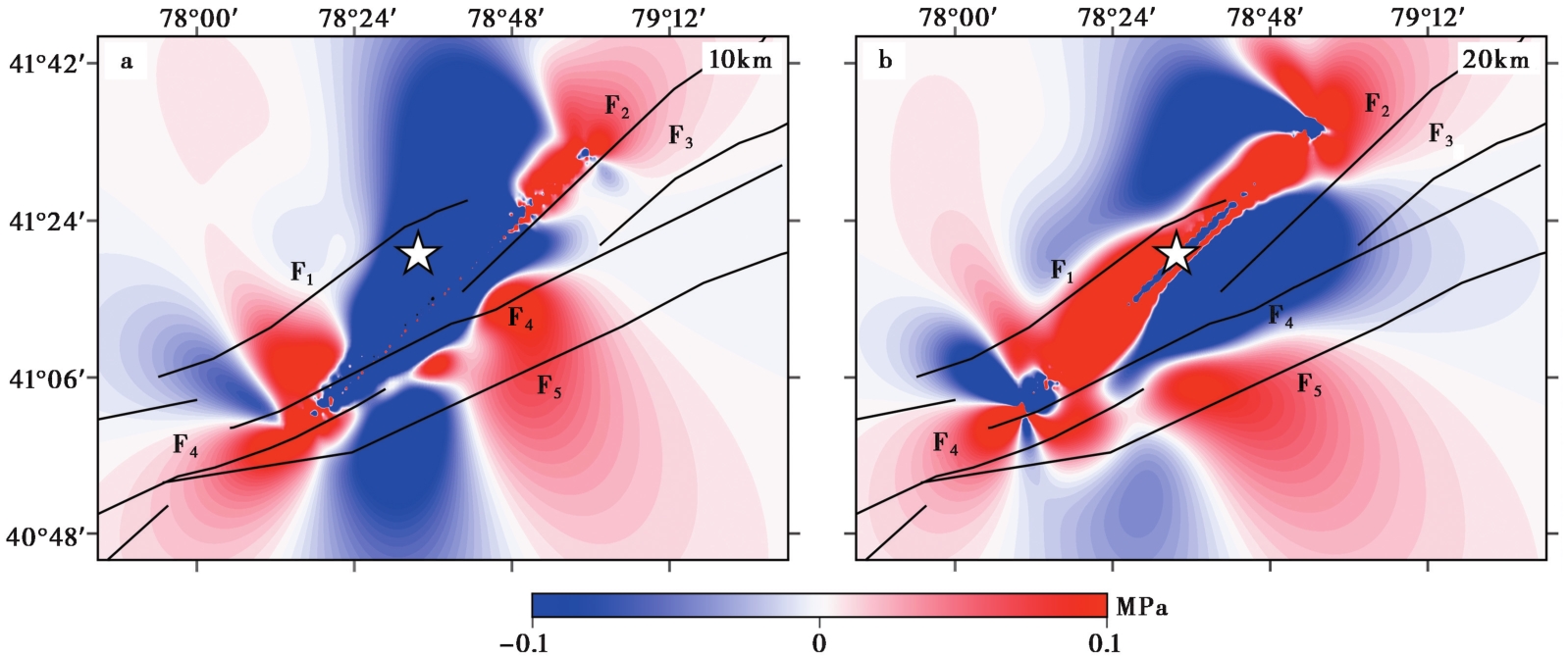
Fig. 6 Coulomb stress variations at depths of 10km and 20km caused by the Wushi earthquake.
| [1] |
薄万举, 章思亚, 刘广余, 等. 2006. 新疆乌什6.2 级地震的中期预测[J]. 大地测量与地球动力学, 26(1): 26-30.
|
|
|
|
| [2] |
金明培, 汪荣江. 2013. 用近场强震动记录快速估计同震位移并反演震源滑动分布[J]. 地球物理学报, 56(4): 1207-1215.
|
|
|
|
| [3] |
李雨森, 李为乐, 许强, 等. 2024. 2024年新疆乌什 MS7.1 地震InSAR同震形变探测与断层滑动分布反演[J]. 成都理工大学学报(自然科学版), 51(4): 641-653.
|
|
|
|
| [4] |
黎朕灵. 2019. 用近震源强震动观测数据快速解算同震位移场并反演震源模型[D]. 昆明: 云南大学:45.
|
|
|
|
| [5] |
单新建, 马瑾, 王长林, 等. 2002. 利用差分干涉雷达测量技术(D-InSAR)提取同震形变场[J]. 地震学报, 24(4): 413-420.
|
|
|
|
| [6] |
单新建, 屈春燕, 龚文瑜, 等. 2017. 2017年8月8日四川九寨沟7.0级地震InSAR同震形变场及断层滑动分布反演[J]. 地球物理学报, 60(12): 4527-4536.
|
|
|
|
| [7] |
石耀霖, 曹建玲. 2010. 库仑应力计算及应用过程中若干问题的讨论: 以汶川地震为例[J]. 地球物理学报, 53(1): 102-110.
|
|
|
|
| [8] |
屠泓为, 汪荣江, 刁法启, 等. 2016. 运用SDM方法研究2001年昆仑山口西 MS8.1 地震破裂分布: GPS和InSAR联合反演的结果[J]. 地球物理学报, 59(6): 2103-2112.
|
|
|
|
| [9] |
万永革. 2001. “地震静态应力触发”问题的研究[D]. 北京: 中国地震局地球物理研究所:7-10.
|
|
|
|
| [10] |
王绍俊, 刘云华, 单新建, 等. 2021. 2021年云南漾濞 MS6.4 地震同震地表形变与断层滑动分布[J]. 地震地质, 43(3): 692-705. doi: 10.3969/j.issn.0253-4967.2021.03.014.
|
|
|
|
| [11] |
徐晓雪, 季灵运, 朱良玉, 等. 2021. 漾濞 MS6.4 地震同震形变特征及发震构造探讨[J]. 地震地质, 43(4): 771-789. doi: 10.3969/j.issn.0253-4967.2021.04.003.
|
|
|
|
| [12] |
于书媛, 黄显良, 郑海刚, 等. 2023. 2022年门源 MW6.7 地震的同震破裂模型及应力研究[J]. 地震地质, 45(1): 286-303.
|
|
|
|
| [13] |
张博譞, 钱黎, 李涛, 等. 2024. 2024年1月23日新疆乌什 MS7.1 地震地质灾害和地表破裂[J]. 地震地质, 46(1): 220-234. doi: 10.3969/j.issn.0253-4967.2024.01.013.
|
|
|
|
| [14] |
|
| [15] |
|
| [16] |
|
| [17] |
|
| [18] |
|
| [19] |
|
| [20] |
|
| [21] |
|
| [1] | LIU Lian, QU Chun-yan, WU Dong-lin, RONG Yi-lin, CHEN Han. THE RUPTURE PROCESS INVERSION OF SEPTEMBER 2022 ML6.6 AND ML6.83 EARTHQUAKES IN TAIWAN ISLAND, CHINA [J]. SEISMOLOGY AND GEOLOGY, 2026, 48(1): 217-232. |
| [2] | LI Xin-yan, ZENG Xian-wei, LI Meng-ya, WEI Ding-jun, CUI Jin. APPARENT RESITIVITY VARIATION AT KEPING SEISMIC STATION BEFORE THE MODERATE EARTHQUAKES IN SOUTH TIANSHAN AREA, XINJIANG [J]. SEISMOLOGY AND GEOLOGY, 2025, 47(5): 1438-1455. |
| [3] | YANG Ying-hui, XIE Li-yuan, XU Qiang, WANG Yun-sheng, ZHAO Jing-jing, WANG Dao-ming, CHEN Qiang. RESEARCH OF THE INSAR COSEISMIC DEFORMATION AND INTERSEISMIC FAULTING MECHANISM OF THE 2023 JISHISHAN MW6.1 EARTHQUAKE [J]. SEISMOLOGY AND GEOLOGY, 2025, 47(5): 1416-1437. |
| [4] | CHEN Zi-long, LIU Gang, LI Qi, CHEN Wei, ZHAO Xin-yu, LIN Mu, TAO Long-wen, QIAO Xue-jun, NIE Zhao-sheng. INSAR COSEISMIC DEFORMATION AND SEISMOGENIC STRUCTURE OF THE 2024 MW7.0 WUSHI EARTHQUAKE [J]. SEISMOLOGY AND GEOLOGY, 2025, 47(2): 429-447. |
| [5] | YANG Jian-wen, JIN Ming-pei, YE Beng, LI Zhen-ling, LI Qing. SOURCE RUPTURE MECHANISM AND STRESS CHANGES TO THE ADJACENT AREA OF JANUARY 7, 2025, MS6.8 DINGRI EARTHQUAKE, XIZANG, CHINA [J]. SEISMOLOGY AND GEOLOGY, 2025, 47(1): 36-48. |
| [6] | XU Fang, LU Ren-qi, WANG Shuai, JIANG Guo-yan, LONG Feng, WANG Xiao-shan, SU Peng, LIU Guan-shen. STUDY ON THE SEISMOTECTONICS OF THE QINGBAIJIANG MS5.1 EARTHQUAKE IN SICHUAN PROVINCE IN 2020 BY MULTIPLE CONSTRAINT METHOD [J]. SEISMOLOGY AND EGOLOGY, 2022, 44(1): 220-237. |
| [7] | HUA Jun, ZHAO De-zheng, SHAN Xin-jian, QU Chun-yan, ZHANG Ying-feng, GONG Wen-yu, WANG Zhen-jie, LI Cheng-long, LI Yan-chuan, ZHAO Lei, CHEN Han, FAN Xiao-ran, WANG Shao-jun. COSEISMIC DEFORMATION FIELD, SLIP DISTRIBUTION AND COULOMB STRESS DISTURBANCE OF THE 2021 MW7.3 MADUO EARTHQUAKE USING SENTINEL-1 INSAR OBSERVATIONS [J]. SEISMOLOGY AND GEOLOGY, 2021, 43(3): 677-691. |
| [8] | WANG Shao-jun, LIU Yun-hua, SHAN Xin-jian, QU Chun-yan, ZHANG Guo-hong, XIE Zhao-di, ZHAO De-zheng, FAN Xiao-ran, HUA Jun, LIANG Shi-ming, ZHANG Ke-liang, DAI Cheng-long. COSEISMIC SURFACE DEFORMATION AND SLIP MODELS OF THE 2021 MS6.4 YANGBI(YUNNAN, CHINA)EARTHQUAKE [J]. SEISMOLOGY AND GEOLOGY, 2021, 43(3): 692-705. |
| [9] | CHANG Liu, YANG Bo, ZHANG Feng-shuang, XU Ming-yuan, YANG Guo-hua. GPS AND LEVELING CONSTRAINED CO-SEISMIC SOURCE AND SLIP DISTRIBUTION OF THE LUSHAN MS7.0 EARTHQUAKE ON 20 APRIL 2013 [J]. SEISMOLOGY AND GEOLOGY, 2017, 39(3): 561-571. |
| Viewed | ||||||
|
Full text |
|
|||||
|
Abstract |
|
|||||
Copyright © SEISMOLOGY AND GEOLOGY, All Rights Reserved.
Tel: 010-62009049/9063 E-mail: dzdz@ies.ac.cn
Powered by Beijing Magtech Co., Ltd.