
SEISMOLOGY AND GEOLOGY ›› 2026, Vol. 48 ›› Issue (3): 741-756.DOI: 10.3969/j.issn.0253-4967.20240159
• Research paper • Previous Articles Next Articles
GRAVITY ISOSTASY AND DEEP SEISMOGENIC ENVIRONMENT IN THE MIDDLE SEGMENT OF THE TANLU FAULT ZONE
WANG Xin1)( ), GAO Min2), QIAO Ji-hua1),*(), XIANG Jian-bin1), XU Yu-chen1), FAN Ji-di1)
- 1)
National Institute of Natural Hazards ,MEMC
2)Petroleum Exploration and Production Research Institute ,SINOPEC
-
Received:2025-03-16Revised:2025-05-22Online:2026-06-20Published:2026-07-09
郯庐断裂带中段重力均衡及深部孕震环境
王鑫1)(), 高敏2), 乔计花1),*(), 向健斌1), 徐雨晨1), 樊继迪1)
- 1)
应急管理部国家自然灾害防治研究院
2)中国石化石油勘探开发研究院
-
通讯作者:*乔计花, 女, 1977年生, 研究员, 主要研究方向为重磁技术与地球信息探测, E-mail: jihuaqiao@ninhm.ac.cn。 -
作者简介:王鑫, 男, 1986年生, 副研究员, 主要研究方向为重力学、地磁学及地球深部结构研究, E-mail: wangxindzdz@163.com。
-
基金资助:地球深部探测与矿产资源勘查国家科技重大专项课题(2024ZD1000707); 国家消防救援局科技计划重点研发项目(2024XFZD01)

Cite this article
WANG Xin, GAO Min, QIAO Ji-hua, XIANG Jian-bin, XU Yu-chen, FAN Ji-di. GRAVITY ISOSTASY AND DEEP SEISMOGENIC ENVIRONMENT IN THE MIDDLE SEGMENT OF THE TANLU FAULT ZONE[J]. SEISMOLOGY AND GEOLOGY, 2026, 48(3): 741-756.
王鑫, 高敏, 乔计花, 向健斌, 徐雨晨, 樊继迪. 郯庐断裂带中段重力均衡及深部孕震环境[J]. 地震地质, 2026, 48(3): 741-756.
share this article
Add to citation manager EndNote|Ris|BibTeX
URL: https://www.dzdz.ac.cn/EN/10.3969/j.issn.0253-4967.20240159

Fig. 1 Seismotectonic map of the middle segment of the Tanlu fault zone and adjacent areas.

Fig. 2 Bouguer gravity anomaly and directional derivative gravity field.
| 地层 | 厚度/km | P波速度/km·s-1 | 密度/g·cm-3 |
|---|---|---|---|
| 沉积层 | 0~5 | ≤5.5 | ≤2.53 |
| 上地壳 | 10~15 | 5.8~6.2 | 2.62~2.75 |
| 中地壳 | 8~10 | 6.3~6.5 | 2.79~2.85 |
| 下地壳 | 5~10 | 6.8~7.0 | 2.94~3.07 |
| 上地幔 | 7.8 | 3.27 |
Table1 List of average crustal depth, P wave velocity and crustal density
| 地层 | 厚度/km | P波速度/km·s-1 | 密度/g·cm-3 |
|---|---|---|---|
| 沉积层 | 0~5 | ≤5.5 | ≤2.53 |
| 上地壳 | 10~15 | 5.8~6.2 | 2.62~2.75 |
| 中地壳 | 8~10 | 6.3~6.5 | 2.79~2.85 |
| 下地壳 | 5~10 | 6.8~7.0 | 2.94~3.07 |
| 上地幔 | 7.8 | 3.27 |
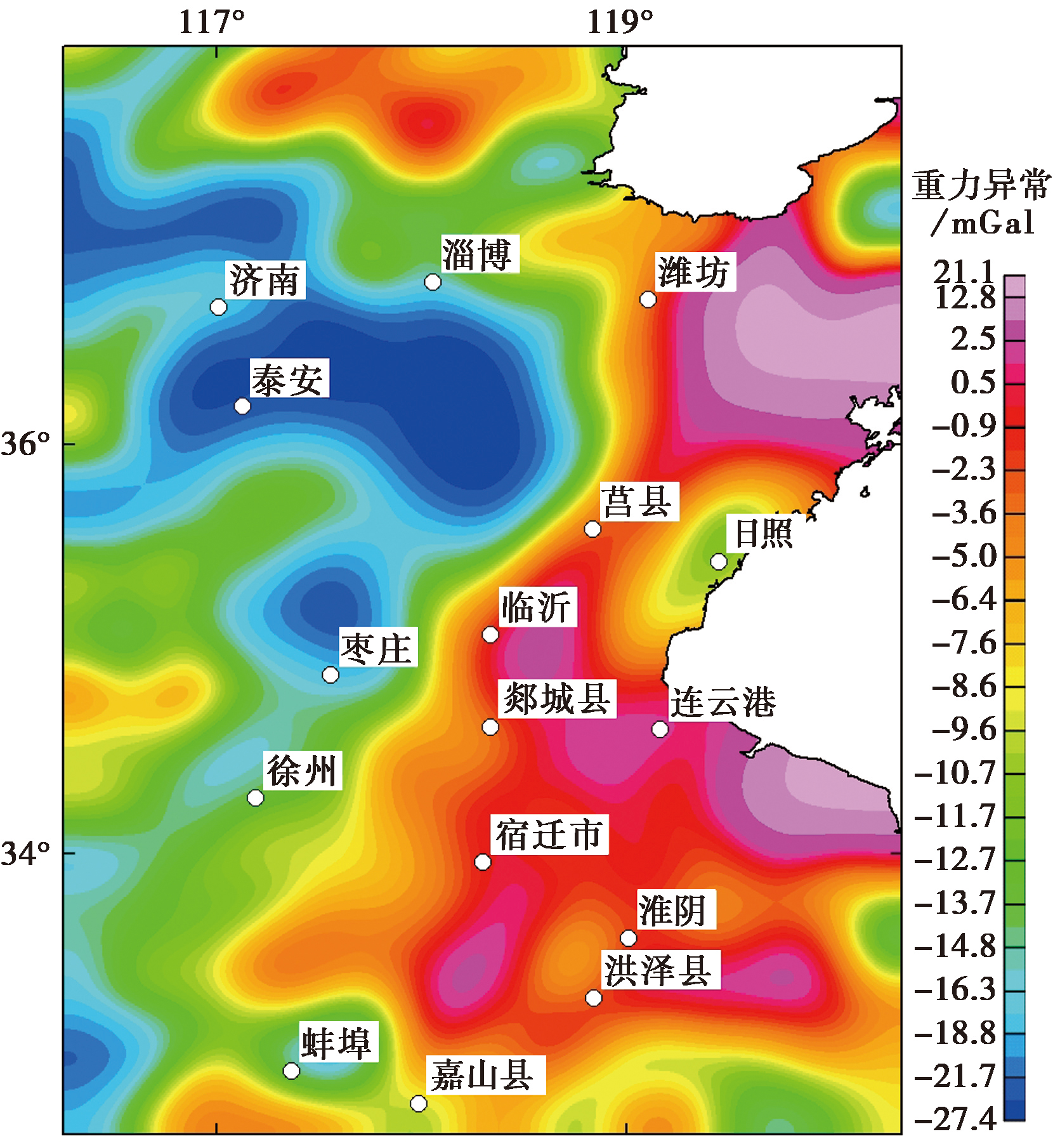
Fig. 3 The 4th order approximate gravity field.
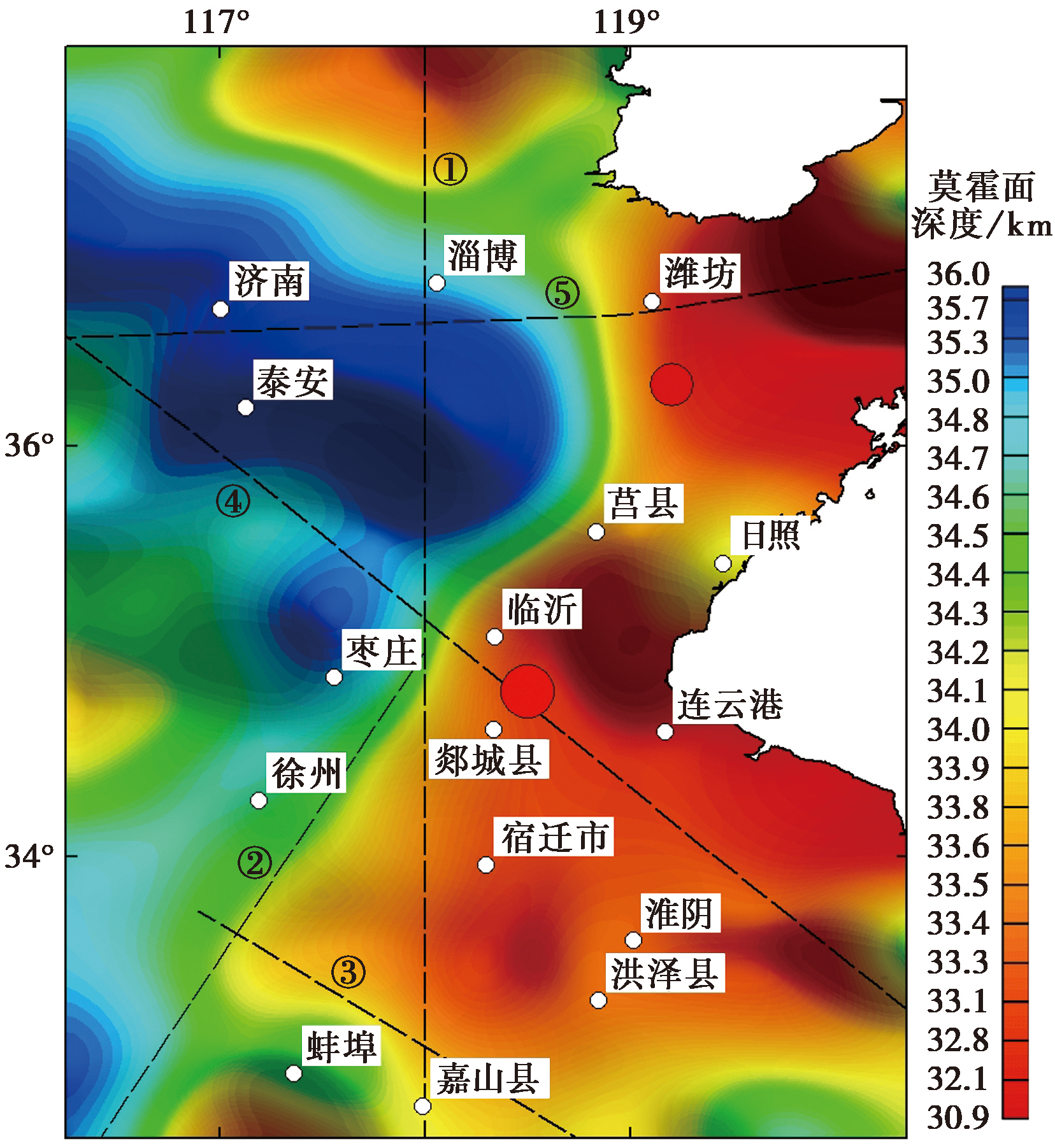
Fig. 4 Moho depth.
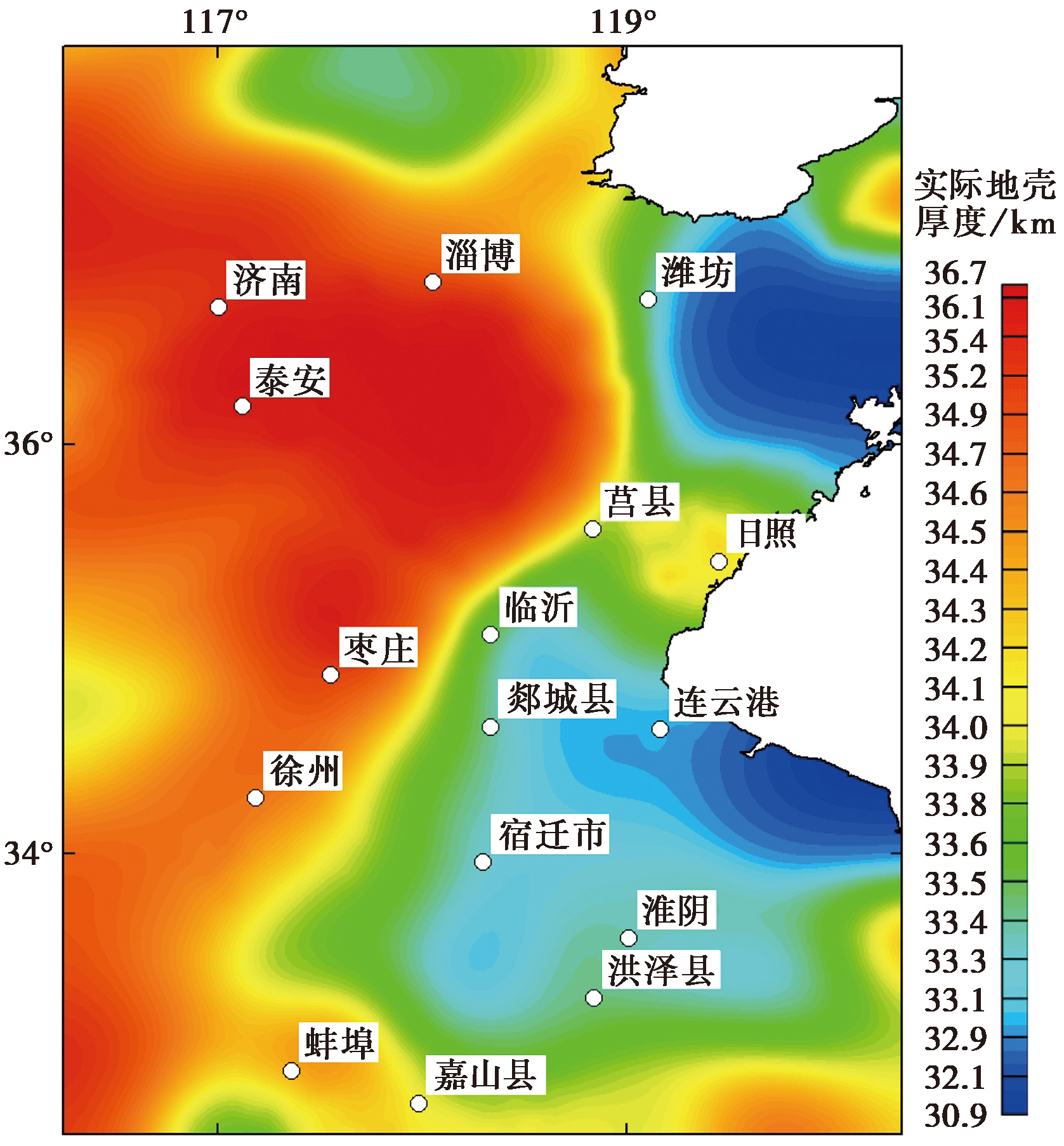
Fig. 5 Crustal thickness.
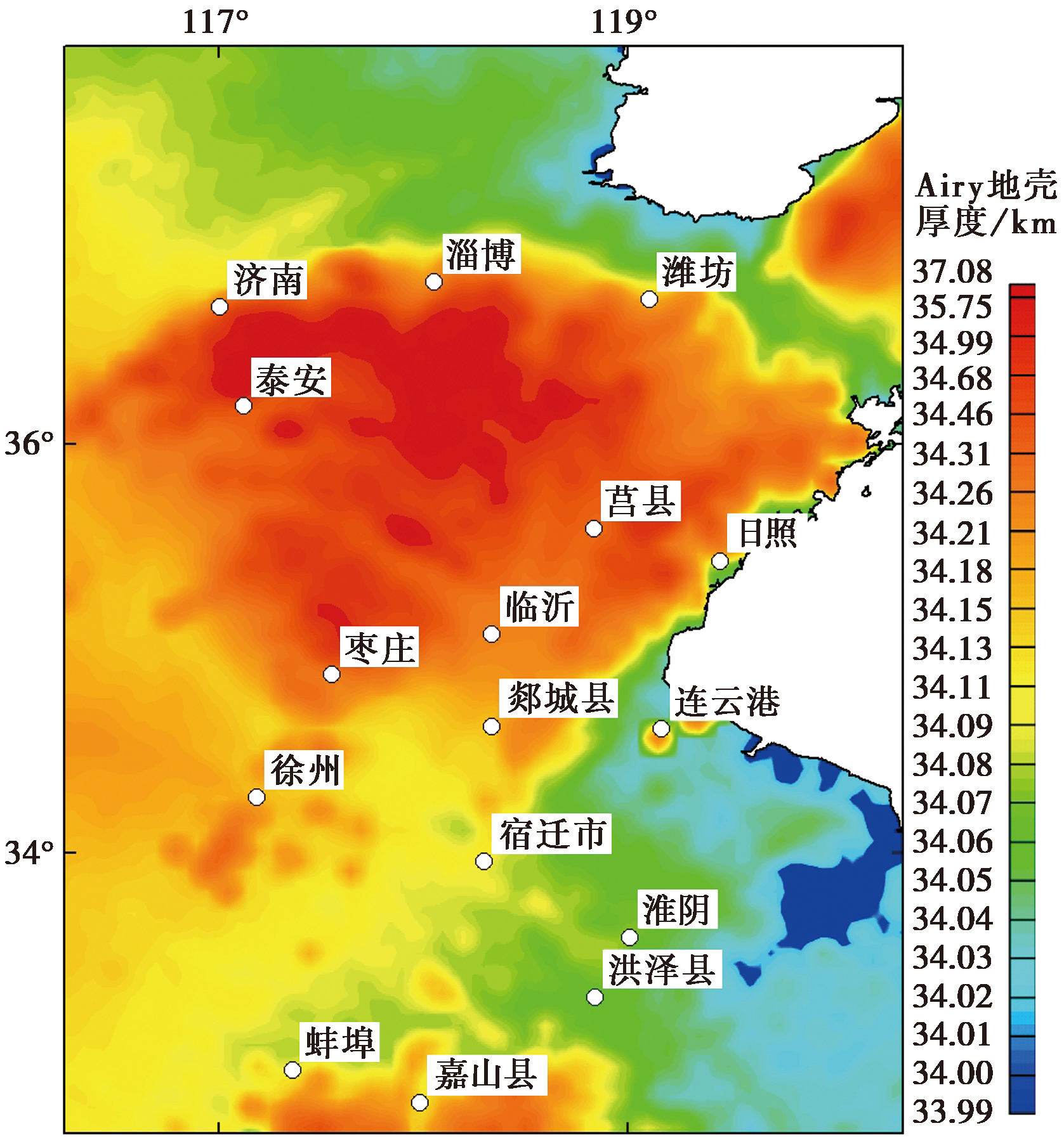
Fig. 6 Crustal thickness of Airy isostasy.
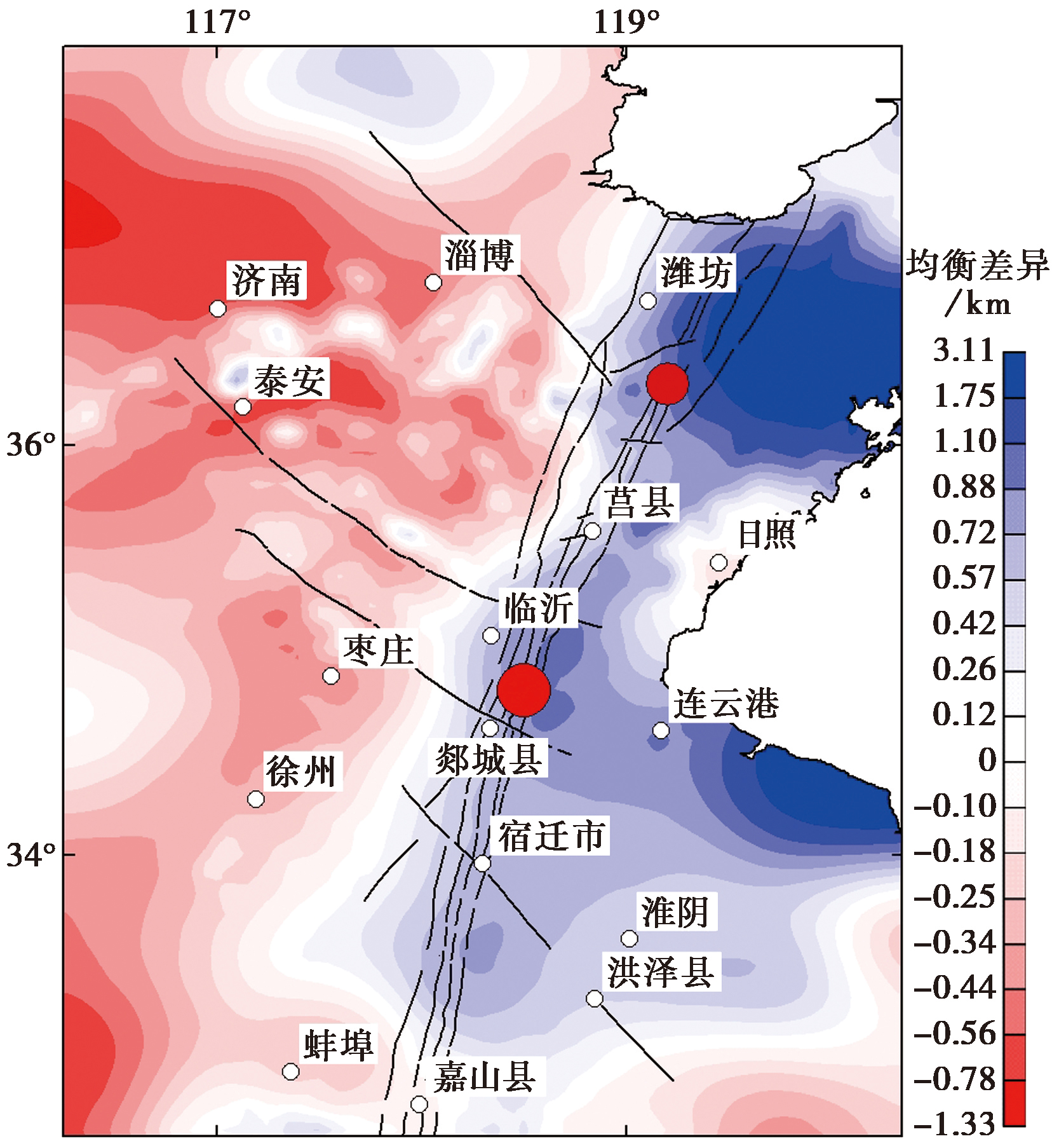
Fig. 7 The isostatic difference of crustal thickness.
| [1] |
白志明, 王椿镛. 2006. 下扬子地壳P波速度结构: 符离集-奉贤地震测深剖面再解释[J]. 科学通报, 51(21): 2534-2541.
|
|
DOI URL |
|
| [2] |
晁洪太, 崔昭文, 李家灵. 1992. 鲁中地区NW向断裂及其第四纪晚期的活动特征[J]. 地震学刊, 2: 1-10.
|
|
DOI |
|
| [3] |
晁洪太, 李家灵, 崔昭文, 等. 1997. 郯庐断裂带潍坊-嘉山段全新世活断层的活动方式与发震模式[J]. 地震研究, 20(2): 218-226.
|
|
|
|
| [4] |
陈艳, 张景发, 姜文亮, 等. 2017. 苏北盆地重力场及地壳结构特征[J]. 地球物理学进展, 32(6): 2295-2303.
|
|
|
|
| [5] |
邓起东. 2007. 中国活动构造图[M]. 北京: 地震出版社.
|
|
|
|
| [6] |
杜晓娟, 孟令顺, 张凤旭, 等. 2005. 利用重磁场研究郯庐断裂及周边构造[J]. 吉林大学学报(地球科学版), 35(S1): 51-56.
|
|
|
|
| [7] |
柯小平, 王勇, 许厚泽. 2006. 基于变密度模型的位场界面反演[J]. 地球物理学进展, 21(3): 825-829.
|
|
|
|
| [8] |
李家灵, 晁洪太, 崔昭文, 等. 1994. 郯庐活断层的分段及其大震危险性分析[J]. 地震地质, 16(2): 121-126.
|
|
|
|
| [9] |
满洪敏. 2005. 沂沭断裂带内部的差异活动及其成因分析[J]. 华北地震科学, 23(3): 13-21.
|
|
|
|
| [10] |
施炜, 张岳桥, 董树文. 2003. 郯庐断裂带中段第四纪活动及其分段特征[J]. 地球学报, 24(1): 11-18.
|
|
|
|
| [11] |
宋明春. 2008. 山东省大地构造单元组成、背景和演化[J]. 地质调查与研究, 31(3): 165-175.
|
|
|
|
| [12] |
唐新功, 陈永顺, 唐哲. 2006. 应用布格重力异常研究郯庐断裂构造[J]. 地震学报, 28(6): 603-610.
|
|
|
|
| [13] |
王谦身, 滕吉文, 张永谦, 等. 2008. 龙门山断裂系及邻区地壳重力均衡效应与汶川地震[J]. 地球物理学进展, 23(6): 1664-1670.
|
|
|
|
| [14] |
王谦身, 张赤军, 安玉林, 等. 2003. 重力学[M]. 地震出版社.
|
|
|
|
| [15] |
徐纪人, 赵志新. 2004. 苏鲁造山代区域地壳山根结构特征[J]. 岩石学报, 20(1): 149-156.
|
|
|
|
| [16] |
翟明国, 朱日祥, 刘建明, 等. 2003. 华北东部中生代构造体制转折的关键时限[J]. 中国科学(D辑), 33(10): 9l3-920.
|
|
|
|
| [17] |
张岳桥, 董树文. 2008. 郯庐断裂带中生代构造演化史: 进展与新认识[J]. 地质通报, 27(9): 1371-1390.
|
|
|
|
| [18] |
张忠义, 吴淦国, 宋明春, 等. 2004. 苏鲁高压-超高压带的结构、变形特征及形成背景探讨[J]. 地球学报, 25(6): 607-614.
|
|
|
|
| [19] |
朱光, 刘国生,
|
|
|
|
| [20] |
朱光, 王道轩, 刘国生, 等. 2004b. 郯庐断裂带的演化及其对西太平洋板块运动的响应[J]. 地质科学, 39(1): 36-49.
|
|
|
|
| [21] |
朱光, 谢成龙, 王勇生, 等. 2005. 郯庐高压走滑韧性剪切带特征及其 40Ar/39Ar定年[J]. 岩石学报, 21(6): 1687-1702.
|
|
|
|
| [22] |
DOI URL |
| [23] |
|
| [24] |
|
| [25] |
DOI URL |
| [26] |
DOI |
| [27] |
|
| [28] |
DOI URL |
| [29] |
DOI URL |
| [30] |
|
| [31] |
DOI URL |
| [32] |
|
| [33] |
|
| [34] |
DOI URL |
| [35] |
|
| [36] |
|
| [1] | LUO Xiang-fei, LI Zhong-liang, WANG Ze-yuan, YU Bo, JI Ji-fa, HAO Peng-fei, LIU Dong-yang, HE Wei-min. DEEP STRUCTURAL CHARACTERISTIC OF MAJOR FAULTS IN THE JIN-JI-MENG BOUNDARY AREA BASED ON BOUGUER GRAVITY DATA [J]. SEISMOLOGY AND GEOLOGY, 2026, 48(3): 774-796. |
| [2] | LIU Wen-yu, CHENG Zheng-pu, NIAN Xiu-qing, CHEN Yan, HU Yu-ling, QIN Zu-jian, SHAO Ming-zheng. GENESIS OF SONGYUAN EARTHQUAKES BASED ON 3D RESIDUAL DENSITY STRUCTURE [J]. SEISMOLOGY AND GEOLOGY, 2024, 46(2): 462-476. |
| [3] | LUO Xiang-fei, LI Zhong-liang, LI Yong-jiang, WANG Ze-yuan, JI Ji-fa, HE Xin, YU Bo. DENSITY STRUCTURE, TECTONIC FEATURES AND SEISMIC ACTIVITY OF THE YICHUAN-TAI’AN PROFILE [J]. SEISMOLOGY AND GEOLOGY, 2023, 45(6): 1385-1399. |
| [4] | XU Zhi-ping, ZHANG Yang, YANG Li-pu, XU Shun-qiang, JIANG Lei, TANG Lin, LIN Ji-yan. STUDY ON THE DEEP STRUCTURAL CHARACTERISTIC OF MAIN ACTIVE FAULTS IN HENAN PROVINCE AND ITS ADJACENT AREAS [J]. SEISMOLOGY AND GEOLOGY, 2022, 44(6): 1521-1538. |
| [5] | WU Gui-ju, YU Bing-fei, HAO Hong-tao, HU Min-zhang, TAN Hong-bo. THE DEEP STRUCTURAL CHARACTERISTICS AND THE SEIS-MOGENIC STRUCTURE OF THE YANGBI EARTHQUAKE REGION AND ITS SURROUNDING AREAS [J]. SEISMOLOGY AND EGOLOGY, 2021, 43(4): 739-756. |
| [6] | LI Zhe-jun, YI Chong-zheng, ZHOU Dong-rui, ZHENG Hai-gang, WANG Jun, LI Jun-hui, NI Hong-yu. MULTI-SCALE DECOMPOSITION OF GRAVITY ANOMALY OF THE EASTERN DABIE OROGEN AND ITS TECTONIC IMPLICATIONS [J]. SEISMOLOGY AND GEOLOGY, 2021, 43(1): 158-176. |
| [7] | XU Zhi-ping, WANG Fu-yun, JIANG Lei, XU Shun-qiang, TANG Lin. THE DEPTH OF MOHO INTERFACE AND CRUSTAL THICKNESS IN SICHUAN-YUNNAN REGION, CHINA [J]. SEISMOLOGY AND GEOLOGY, 2018, 40(6): 1318-1331. |
| [8] | JIANG Lei, XU Zhi-ping, FANG Sheng-ming, YANG Li-pu, LI Yi-qing, XU Shun-qiang. DEEP STRUCTURE OF NORTHERN HENAN PROVINCE AND ADJACENT AREAS DERIVED FROM GRAVITY AND SEISMIC SOUNDING DATA IN RELATION TO DISTRIBUTION OF EARTHQUAKES [J]. SEISMOLOGY AND GEOLOGY, 2018, 40(2): 323-336. |
| [9] | TAN Hong-bo, SHEN Chong-yang, XUAN Song-bai, WU Gui-ju, YANG Guang-liang, WANG Jian. THE SEISMOGENIC ENVIRONMENT ANALYSIS OF LUDIAN MS6.5 EARTHQUAKE USING GRAVITY DATA [J]. SEISMOLOGY AND GEOLOGY, 2017, 39(2): 356-373. |
| [10] | WANG Xin, ZHANG Jing-fa, JIANG Wen-liang, JIANG Hong-bo, TIAN Tian, GAO Min, FU Ping-jie. TRANSVERSE STRUCTURES FEATURES OF DIFFERENT DEPTHS DERIVED FROM BOUGUER GRAVITY ANOMALIES IN THE SOUTHERN SEGMENT OF TAN-LU FAULT ZONE [J]. SEISMOLOGY AND GEOLOGY, 2016, 38(2): 370-385. |
| [11] | WANG Xin, ZHANG Jing-fa, FU Ping-jie, GAO Min. DEEP STRUCTURES OF YISHU FAULT ZONE DERIVED FROM GRAVITY DATA [J]. SEISMOLOGY AND GEOLOGY, 2015, 37(3): 731-747. |
| [12] | LIU Guo-cheng, QIN Zun-li, HE Ri-zheng, WU Yan-gang. ISOSTATIC GRAVITY ANOMALY AND DENSITY STRUCTURE BENEATH POTASSIC VOLCANIC REGION IN NORTHERN TIBET [J]. SEISMOLOGY AND GEOLOGY, 2013, 35(4): 817-832. |
| [13] | Yin Xiuhua, Li Yishi, Liu Zhanpo. GRAVITY FIELD AND CRUST UPPER MANTLE STRUCTURE OVER THE TARIM BAISIN [J]. SEISMOLOGY AND GEOLOGY, 1998, 20(4): 370-378. |
| [14] | Yin Xiu-hua, Liu Zhan-po, Wu Ji-xin, Wang Ghun-hua, Liu Tie-sheng. THE FEATURES OF BOUGUER GRAVITY FIELD AND STRUCTURES OF CRUST-UPPER MANTLE IN THE TRANSITION ZONE ON THE EASTERN BORDER OF QINGHAI-XIZHANG-MONGOLIAN PLATEAU [J]. SEISMOLOGY AND GEOLOGY, 1988, 10(4): 143-150. |
| Viewed | ||||||
|
Full text |
|
|||||
|
Abstract |
|
|||||
Copyright © SEISMOLOGY AND GEOLOGY, All Rights Reserved.
Tel: 010-62009049/9063 E-mail: dzdz@ies.ac.cn
Powered by Beijing Magtech Co., Ltd.