
SEISMOLOGY AND GEOLOGY ›› 2026, Vol. 48 ›› Issue (3): 724-740.DOI: 10.3969/j.issn.0253-4967.20250003
• Research paper • Previous Articles Next Articles
EVIDENCE OF THE HOLOCENE ACTIVITY IN THE NORTHERN SEGMENT OF YANTONGSHAN FAULT
LIU Chao1,2)( ), REN Zhi-kun1),*(), LIU Jin-rui1), JI Hao-min1), WU Zhi-qun2), YU Si-han2), LEI Qi-yun2), DU Peng2)
- 1)
State Key Laboratory of Earthquake Dynamicsand Forecasting ,Instituteof Geology, China Earthquake Administration
2)Earthquake Administration of Ning xia Hui Autonomous Region
-
Received:2025-01-08Revised:2025-02-11Online:2026-06-20Published:2026-07-09
烟筒山断裂北段全新世活动证据
刘超1,2)(), 任治坤1),*(), 刘金瑞1), 计昊旻1), 武治群2), 余思汗2), 雷启云2), 杜鹏2)
- 1)
地震动力学与强震预测全国重点实验室(中国地震局地质研究所)
2)宁夏回族自治区地震局
-
通讯作者:*任治坤, 男, 1980年生, 研究员, 博士生导师, 主要从事活动构造与构造地貌研究, E-mail: rzk@ies.ac.cn。 -
作者简介:刘超, 男, 1991年生, 高级工程师, 现为中国地震局地质研究所构造地质学专业在读博士研究生, 主要从事活动构造、构造地貌及城市活动断层探测方面的研究工作, E-mail: liuchao0426@126.com。
-
基金资助:宁夏回族自治区重点研发计划重点项目(2024BEG02033); 国家自然科学基金(U2239202); 科技部项目(2021FY100103); 中国地震局地震科技星火计划项目(XH26030A); 宁夏回族自治区自然科学基金(2020AAC03443); 宁夏回族自治区自然科学基金(2023AAC03815); 2023年度自治区青年科技托举人才培养项目

Cite this article
LIU Chao, REN Zhi-kun, LIU Jin-rui, JI Hao-min, WU Zhi-qun, YU Si-han, LEI Qi-yun, DU Peng. EVIDENCE OF THE HOLOCENE ACTIVITY IN THE NORTHERN SEGMENT OF YANTONGSHAN FAULT[J]. SEISMOLOGY AND GEOLOGY, 2026, 48(3): 724-740.
刘超, 任治坤, 刘金瑞, 计昊旻, 武治群, 余思汗, 雷启云, 杜鹏. 烟筒山断裂北段全新世活动证据[J]. 地震地质, 2026, 48(3): 724-740.
share this article
Add to citation manager EndNote|Ris|BibTeX
URL: https://www.dzdz.ac.cn/EN/10.3969/j.issn.0253-4967.20250003

Fig. 1 Regional tectonic map.

Fig. 2 Geometric map of the northern Yantongshan Fault segment and natural fault sections.

Fig. 3 Geomorphology near Xingjiayao and fault trace.
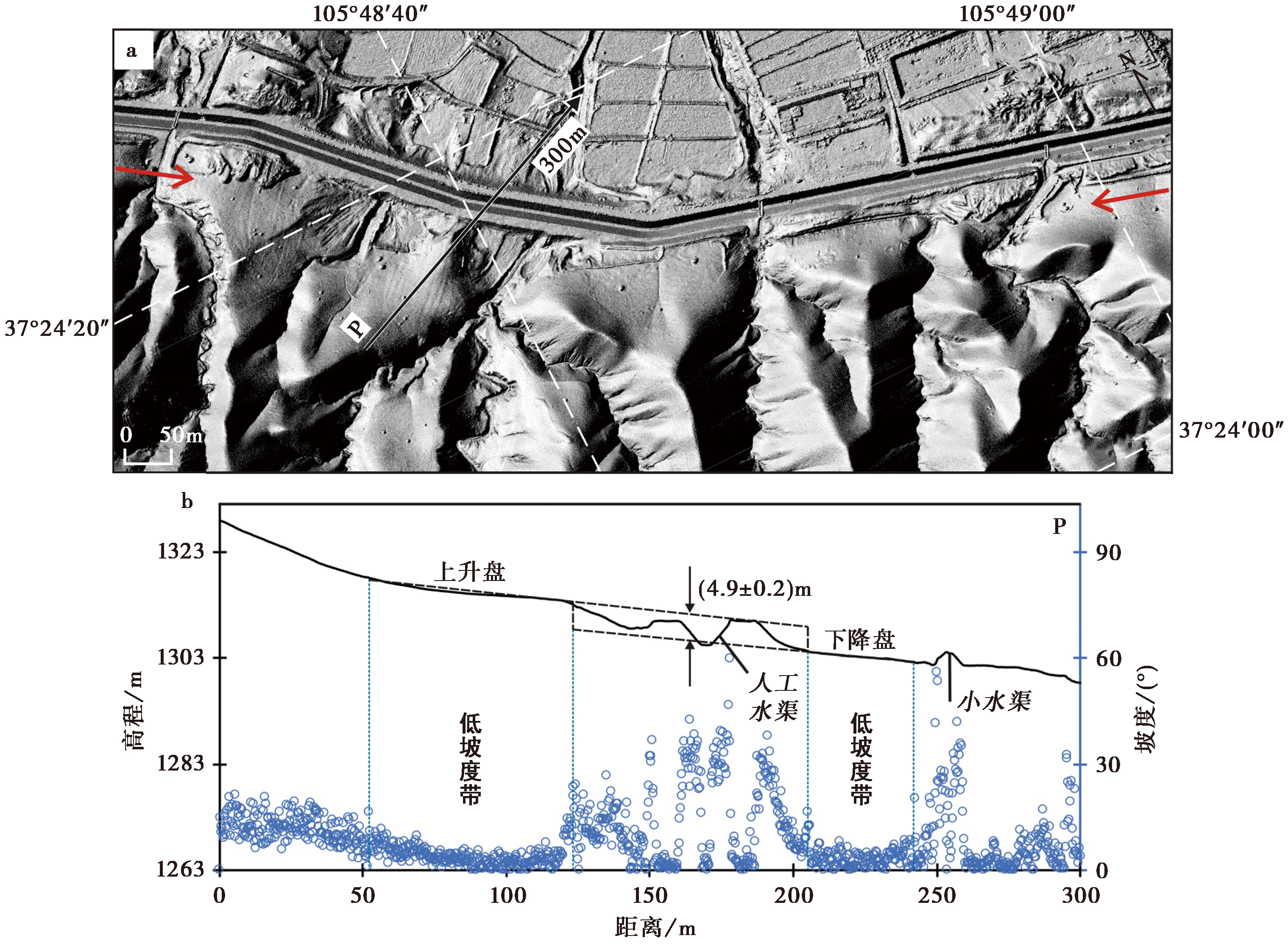
Fig. 4 Fault geomorphology and vertical dislocation derived from topographic profile.
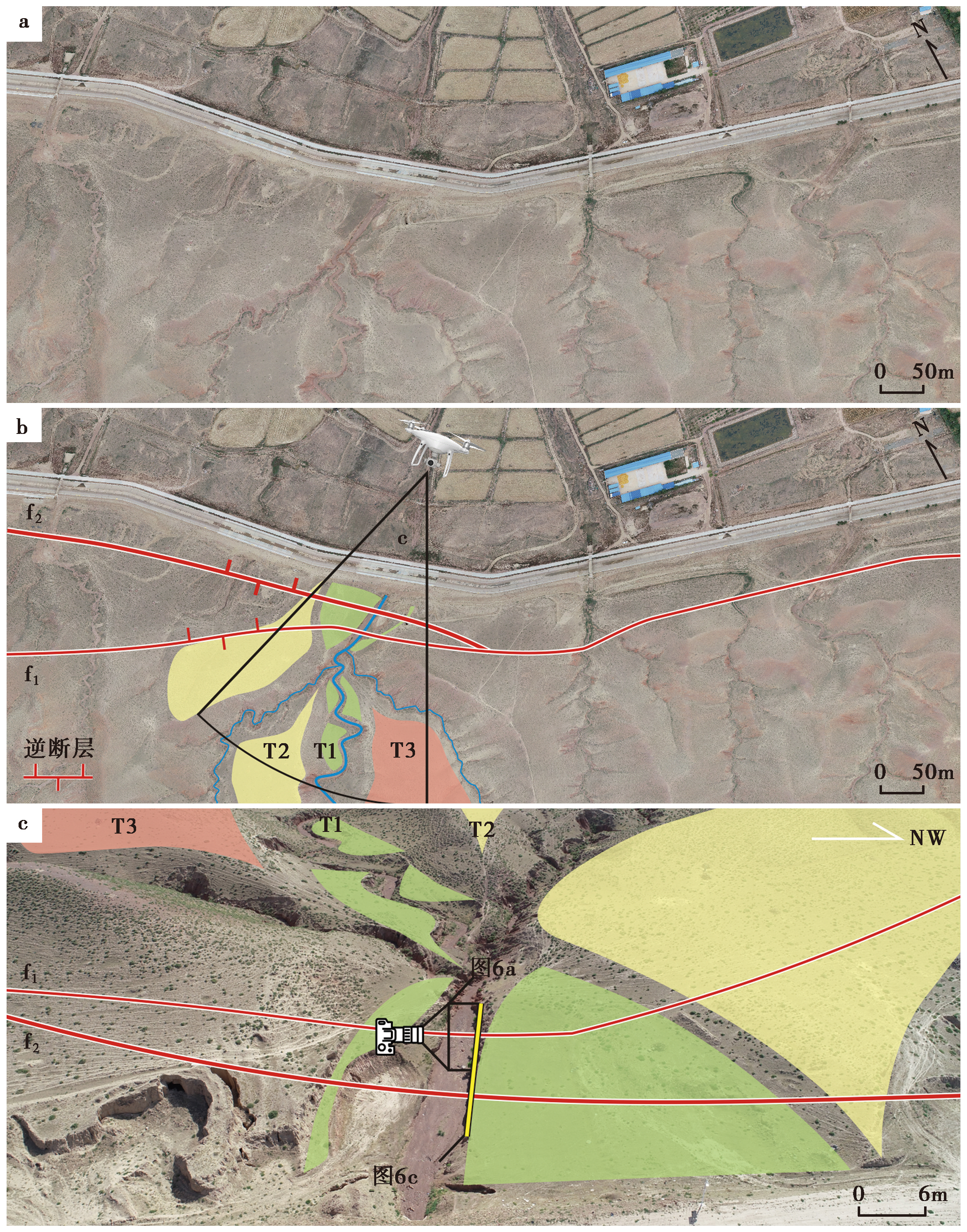
Fig. 5 Schematic diagram of trench excavation sites.
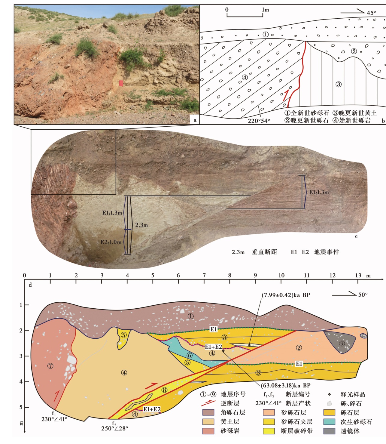
Fig. 6 Trench exposure and corresponding interpretation.
| 层位 | 深度 /m | U /ppm | Th /ppm | K /% | 含水率 /% | 剂量率 /Gy·ka-1 | 等效剂量 /Gy | 年龄 /ka |
|---|---|---|---|---|---|---|---|---|
| ③ | 1.8 | 2.70±0.37 | 10.10±1.0 | 1.62±0.10 | 10±5 | 3.52±0.17 | 28.13±0.59 | 7.99±0.42 |
| ④ | 2.0 | 2.30±0.23 | 10.20±1.0 | 1.72±0.13 | 5±1 | 3.68±0.14 | 232.45±7.74 | 63.08±3.18 |
Table2 Results of Optically Stimulated Luminescence(OSL)dating for samples
| 层位 | 深度 /m | U /ppm | Th /ppm | K /% | 含水率 /% | 剂量率 /Gy·ka-1 | 等效剂量 /Gy | 年龄 /ka |
|---|---|---|---|---|---|---|---|---|
| ③ | 1.8 | 2.70±0.37 | 10.10±1.0 | 1.62±0.10 | 10±5 | 3.52±0.17 | 28.13±0.59 | 7.99±0.42 |
| ④ | 2.0 | 2.30±0.23 | 10.20±1.0 | 1.72±0.13 | 5±1 | 3.68±0.14 | 232.45±7.74 | 63.08±3.18 |
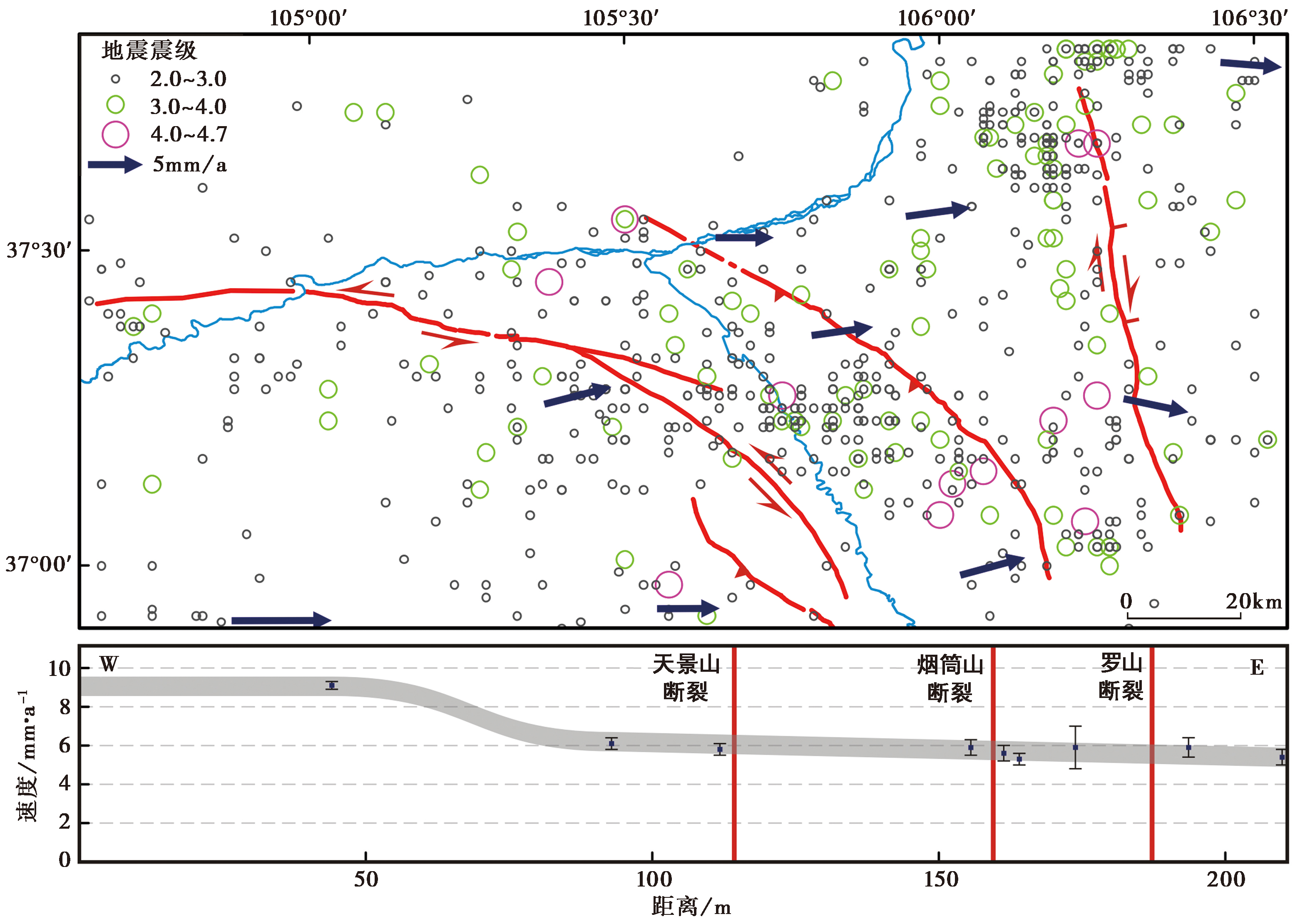
Fig. 7 Microseismic epicenters from 1970 to 2021 and velocity field in the Eurasian Reference Frame(Data from Wang et al., 2020).
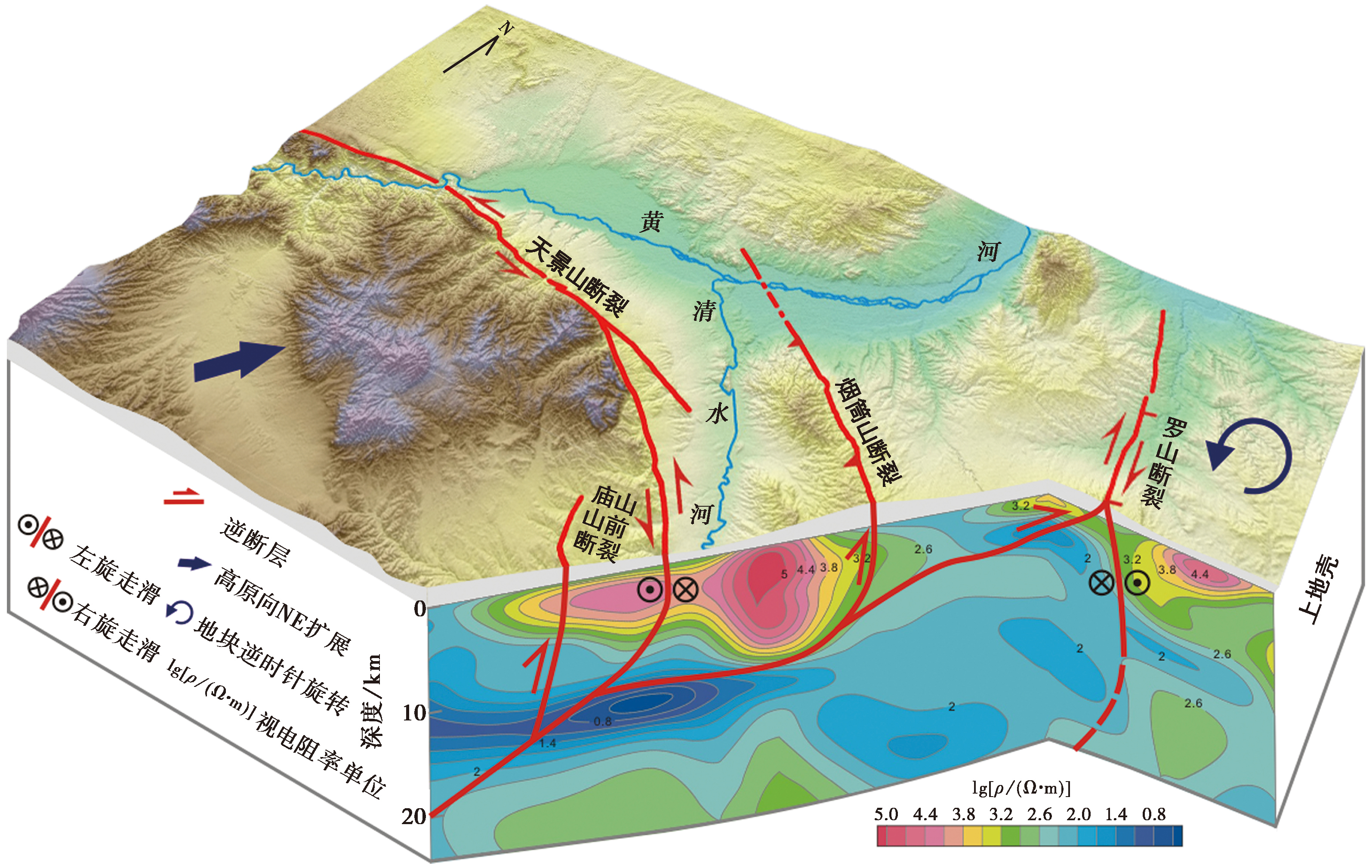
Fig. 8 The diagram of regional 3D tectonics model(Magnetotelluric data from YIN Bing-xi et al., 2013).
| [1] |
柴炽章, 张维歧, 焦德成. 1997. 天景山断裂带晚第四纪水平活动强度的分时、分段研究[J]. 中国地震, 13(1): 35-42.
|
|
|
|
| [2] |
陈国星, 田勤俭, 周本刚, 等. 2006. 黄河黑山峡大柳树坝址若干地震地质问题的研究[J]. 震灾防御技术, 1(3): 186-198.
|
|
|
|
| [3] |
董金元, 罗全星, 李新男, 等. 2021. 天景山断裂带晚第四纪左旋走滑运动速率确定及其空间分布特征[J]. 地球学报, 42(4): 527-536.
|
|
|
|
| [4] |
董晓朋, 李振宏, 黄婷, 等. 2020. 宁夏红寺堡盆地隐伏古隆起成因机制及其对区域沙漠化的影响[J]. 地球科学与环境学报, 42(5): 688-700.
|
|
|
|
| [5] |
国家地震局地质研究所, 宁夏回族自治区地震局. 1990. 海原断裂带[M]. 北京: 地震出版社.
|
|
Institute of Geology, State Seismological Bureau, Earthquake Agency of Ningxia Hui Autonomous Region. 1990. The active Haiyuan fault zone[M]. Seismological Press, Beijing (in Chinese).
|
|
| [6] |
黄婷. 2020. 青藏高原东北缘红寺堡盆地晚更新世沉积演化及其地质意义[D]. 北京: 中国地质大学.
|
|
|
|
| [7] |
雷启云, 张培震, 郑文俊, 等. 2016. 青藏高原东北缘三关口-牛首山断裂的右旋走滑与弧形构造带扩展[J]. 中国科学(D辑), 46(5): 691-705.
|
|
|
|
| [8] |
李传友. 2005. 青藏高原东北部几条主要断裂带的定量研究[D]. 北京: 中国地震局地质研究所.
|
|
|
|
| [9] |
李新男. 2014. 香山-天景山断裂带西段晚第四纪运动学特征与古地震研究[D]. 北京: 中国地震局地质研究所.
|
|
|
|
| [10] |
凌媛, 陈凌, 危自根, 等. 2017. 利用噪声层析成像研究华北克拉通中-西部南段及邻区祁连造山带地壳S波各向异性速度结构[J]. 中国科学(地球科学), 47(10): 1202-1219.
|
|
|
|
| [11] |
刘超, 雷启云, 余思汗, 等. 2021. 基于无人机摄影测量技术的地震地表破裂带定量参数提取: 以1709年中卫南M7½地震为例[J]. 地震学报, 43(1): 113-123.
|
|
|
|
| [12] |
闵伟. 1998. 区域古地震研究: 以青藏高原东北缘和华北西缘为例[D]. 北京: 中国地震局地质研究所.
|
|
|
|
| [13] |
闵伟, 张培震, 邓起东. 2001. 中卫-同心断裂带全新世古地震研究[J]. 地震地质, 23(3): 357-366.
|
|
|
|
| [14] |
田勤俭, 申旭辉, 韦开波. 2001. 中卫-同心断裂带构造演化阶段初步研究[M]//卢演俦. 新构造与环境. 北京: 地震出版社: 399-406.
|
|
|
|
| [15] |
王帅军, 刘保金, 田晓峰, 等. 2019. 青藏高原东北缘地壳P波速度结构及其对地壳变形研究的启示[J]. 中国科学(地球科学), 49(2): 368-382.
|
|
|
|
| [16] |
王伟涛. 2011. 宁夏南部新生代盆地沉积演化及其对青藏高原东北角构造变形的响应[D]. 北京: 中国地震局地质研究所.
|
|
|
|
| [17] |
王伟涛, 张培震, 雷启云. 2013. 牛首山-罗山断裂带的变形特征及其构造意义[J]. 地震地质, 35(2): 195-207. doi: 10.3969/j.issn.0253-4967.2013.02.001.
|
|
DOI |
|
| [18] |
尹秉喜, 程建华, 闵刚, 等. 2013. 宁南弧形构造带甘肃靖远-宁夏盐池剖面中上地壳电性结构特征[J]. 地学前缘, 20(4): 332-339.
|
|
|
|
| [19] |
张培震, 王伟涛, 甘卫军, 等. 2022. 青藏高原的现今构造变形与地球动力过程[J]. 地质学报, 96(10): 3297-3313.
|
|
|
|
| [20] |
张维歧, 焦德成, 柴炽章, 等. 2015. 天景山活动断裂带[M]. 北京: 地震出版社.
|
|
|
|
| [21] |
郑文俊, 王庆良, 袁道阳, 等. 2020. 活动地块假说理论框架的提出、发展及未来需关注的科学问题[J]. 地震地质, 42(2): 245-270. doi: 10.3969/j.issn.0253-4967.2020.02.001.
|
|
DOI |
|
| [22] |
郑文俊, 张竹琪, 郝明, 等. 2022. 强震孕育发生的大陆活动地块理论未来发展与强震预测探索[J]. 科学通报, 67(13): 1352-1361.
|
|
|
|
| [23] |
|
| [24] |
DOI URL |
| [25] |
|
| [26] |
DOI URL |
| [27] |
DOI URL |
| [28] |
DOI URL |
| [29] |
|
| [30] |
|
| [31] |
|
| [32] |
DOI URL |
| [1] | LUO Jia-xin, LI Bin, LI Zi-hong, FAN Kun. CHARACTERISTICS OF VERTICAL SLIP RATE EVOLUTION ALONG THE JIAOCHENG FAULT ZONE, SHANXI, SINCE LATE PLEISTOCENE [J]. SEISMOLOGY AND GEOLOGY, 2026, 48(1): 43-63. |
| [2] | YANG Jiu-yuan, WEN Yang-mao, XU Cai-jun, YANG Jian-bing. SEISMOGENIC STRUCTURE OF THE DINGRI MW5.7 EARTH-QUAKE OF MARCH 20, 2020 (SOUTHERN QINGHAI-XIZANG PLATEAU) CONSTRAINED BY THE COSEISMIC AND POSTSEISMIC DEFORMATION [J]. SEISMOLOGY AND GEOLOGY, 2025, 47(4): 1292-1305. |
| [3] | WANG Duo, CHEN Li-chun, LI Yan-bao, WANG Hu, JIA Yong-shun, GAO Yin-yi, XUE Ke-yi. LATE QUATERNARY ACTIVITY OF THE XIETONGMEN TO DENGMECUO SEGMENT ALONG THE XAINZA-DINGGYE RIFT IN SOUTHERN QINGHAI-XIZANG PLATEAU [J]. SEISMOLOGY AND GEOLOGY, 2025, 47(3): 718-733. |
| [4] | WANG Lei, REN Zhi-kun, HE Zhong-tai, JI Hao-min, LIU Jin-rui, GUO Long, LI Xing-ao. EVIDENCE OF HOLOCENE ACTIVITY OF NALATI FAULT ZONE WITHIN THE TIANSHAN [J]. SEISMOLOGY AND GEOLOGY, 2024, 46(4): 821-836. |
| [5] | JI Hao, LIU Chun-ru, WEI Chuan-yi, YANG Hui-li, YIN Gong-ming, CHANG Zu-feng. ESR DATING OF CALCITE VEINS AND IMPLICATIONS FOR THE ACTIVITY OF THE JIANCHUAN SECTION OF THE LONGPAN-QIAOHOU FAULT ZONE [J]. SEISMOLOGY AND GEOLOGY, 2024, 46(1): 81-100. |
| [6] | XU Bo, WANG Ping, WANG Hui-ying, GUO Qiao-qiao, SHI Ling-fan, SHI Yu-xiang. GRAIN SIZE AND MICROSTRUCTURE CHARACTERISTICS OF HOLOCENE MEGAFLOOD SLACK WATER DEPOSITS IN THE MIDDLE REACHES OF THE YARLUNG TSANGPO RIVER [J]. SEISMOLOGY AND GEOLOGY, 2023, 45(2): 305-320. |
| [7] | ZHAO Peng, LI Jun-hui, TAO Yue-chao, SHU Peng, FANG Zhen. NEW ACTIVITY PHENOMENA REVEALED BY TRENCH ON THE NORTH SIDE OF NÜSHAN LAKE IN THE TANLU FAULT ZONE AND DISCUSSION [J]. SEISMOLOGY AND GEOLOGY, 2023, 45(2): 338-354. |
| [8] | YANG Chen-yi, LI Xiao-ni, FENG Xi-jie, HUANG Yin-di, PEI Gen-di. SHALLOW STRUCTURE AND QUATERNARY ACTIVITY OF THE TAOCHUAN-HUXIAN FAULT, THE SUB-STRAND OF THE NORTHERN QINLING FAULT ZONE [J]. SEISMOLOGY AND GEOLOGY, 2023, 45(2): 464-483. |
| [9] | ZHENG Hai-gang, YAO Da-quan, ZHAO Peng, YANG Yuan-yuan, HUANG Jin-shui. NEW ACTIVITY CHARACTERISTICS IN THE CHISHAN SECTION OF TAN-LU FAULT ZONE IN HOLOCENE [J]. SEISMOLOGY AND GEOLOGY, 2023, 45(1): 127-138. |
| [10] | BAI Qilegeer, SHEN Jun, XIAO Chun, DAI Xun-ye. TYPICAL REMOTE SENSING IMAGES OF HOLOCENE FAULTS IN GAIZE PAN(I45)IN TIBET [J]. SEISMOLOGY AND GEOLOGY, 2023, 45(1): 92-110. |
| [11] | YANG Yuan-yuan, LI Peng-fei, LU Shuo, SHU Peng, PAN Hao-bo, FANG Liang-hao, ZHENG Hai-gang, ZHAO Peng, ZHENG Ying-ping, YAO Da-quan. PALEOEARTHQUAKES AND VERTICAL SLIP RATES ON THE HUAI RIVER-NÜSHAN LAKE SEGMENT OF FAULT F5 IN THE MIDDLE SECTION OF THE TANLU FAULT ZONE [J]. SEISMOLOGY AND GEOLOGY, 2022, 44(6): 1365-1383. |
| [12] | JIANG Cong, JIANG Chang-sheng, YIN Xin-xin, WANG Rui-jia, ZHAI Hong-yu, ZHANG Yan-bao, LAI Gui-juan, YIN Feng-ling. SPATIOTEMPORAL HETEROGENEITY AND APPLICATION OF b VALUES IN HYDRAULIC FRACTURING INDUCED SEISMICITY [J]. SEISMOLOGY AND GEOLOGY, 2022, 44(5): 1333-1349. |
| [13] | LI Zheng-fang, ZHOU Ben-gang, XIAO Hai-bo. EVALUATION OF RYUKYU-MANILA TRENCH TECTONIC BACKGROUND AND SEISMOGENIC ABILITY [J]. SEISMOLOGY AND EGOLOGY, 2021, 43(6): 1381-1397. |
| [14] | LI Zheng-fang, LI Yan-bao, ZHOU Ben-gang, ZHU Guo-jun, LIU Bao-jin, WU Jian. NEW INSIGHT ON THE HOLOCENE ACTIVITY OF THE EASTERN MARGINAL FAULT OF DAXING UPLIFT, BEIJING PLAIN [J]. SEISMOLOGY AND EGOLOGY, 2021, 43(6): 1671-1681. |
| [15] | CHANG Zu-feng, CHANG Hao, LI Jian-lin, MAO Ze-bin, ZANG Yang. HOLOCENE ACTIVITY AND PALEOEARTHQUAKES OF THE WEIXI-QIAOHOU FAULT [J]. SEISMOLOGY AND EGOLOGY, 2021, 43(4): 881-898. |
| Viewed | ||||||
|
Full text |
|
|||||
|
Abstract |
|
|||||
Copyright © SEISMOLOGY AND GEOLOGY, All Rights Reserved.
Tel: 010-62009049/9063 E-mail: dzdz@ies.ac.cn
Powered by Beijing Magtech Co., Ltd.