
SEISMOLOGY AND GEOLOGY ›› 2023, Vol. 45 ›› Issue (1): 49-66.DOI: 10.3969/j.issn.0253-4967.2023.01.003
Previous Articles Next Articles
GEOLOGICAL DEFORMATION OF THE TUOLI FAULT IN THE WEST JUNGGAR SINCE THE LATE QUATERNARY
YUAN Hao-dong1),2)( ), LI An1),3),*(), HUANG Wei-liang2), HU Zong-kai1),3), ZUO Yu-qi1),3), YANG Xiao-ping1),3)
- 1)State Key Laboratory of Earthquake Dynamics, Institute of Geology, China Earthquake Administration, Beijing 100029, China
2)College of Geological Engineering and Surveying of Chang'an University, Key Laboratory of Western China Mineral Resources and Geological Engineering, Xi'an 710054, China
3)Xinjiang Pamir Intracontinental Subduction National Observation and Research Station, Beijing 100029, China
-
Received:2022-04-24Revised:2022-06-16Online:2023-02-20Published:2023-03-24
西准噶尔地区托里断裂晚第四纪构造变形
原浩东1),2)(), 李安1),3),*(), 黄伟亮2), 胡宗凯1),3), 左玉琦1),3), 杨晓平1),3)
- 1)中国地震局地质研究所, 地震动力学国家重点实验室, 北京 100029
2)长安大学, 地质工程与测绘学院, 西部矿产资源与地质工程教育部重点实验室, 西安 710054
3)新疆帕米尔陆内俯冲国家野外科学观测研究站, 北京 100029
-
通讯作者:* 李安, 男, 1983年生, 副研究员, 研究方向为活动构造和古地震, E-mail: lian@ies.ac.cn。 -
作者简介:原浩东, 男, 1997年生, 现为长安大学和中国地震局地质研究所联合培养地质工程专业在读硕士研究生, 研究方向为活动构造与地震地质, E-mail: 18335528494@163.com。 -
基金资助:中国地震局地质研究所基本科研业务专项(IGCEA2115)
CLC Number:
Cite this article
YUAN Hao-dong, LI An, HUANG Wei-liang, HU Zong-kai, ZUO Yu-qi, YANG Xiao-ping. GEOLOGICAL DEFORMATION OF THE TUOLI FAULT IN THE WEST JUNGGAR SINCE THE LATE QUATERNARY[J]. SEISMOLOGY AND GEOLOGY, 2023, 45(1): 49-66.
原浩东, 李安, 黄伟亮, 胡宗凯, 左玉琦, 杨晓平. 西准噶尔地区托里断裂晚第四纪构造变形[J]. 地震地质, 2023, 45(1): 49-66.
share this article
Add to citation manager EndNote|Ris|BibTeX
URL: https://www.dzdz.ac.cn/EN/10.3969/j.issn.0253-4967.2023.01.003
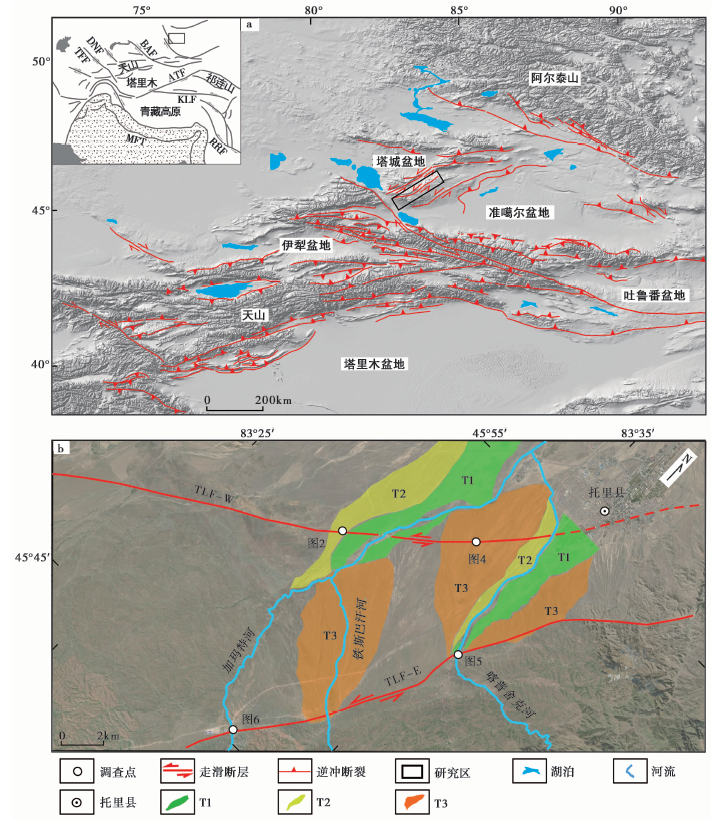
Fig. 1 Regional geological sketch map of the Tianshan-west Junggar and the study area.
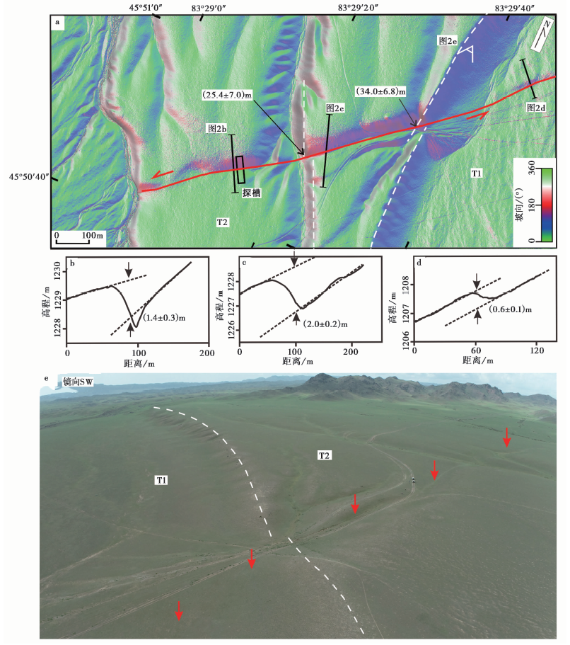
Fig. 2 Fault dislocation of terraces in the west side of the Tiesibahan reservoir.
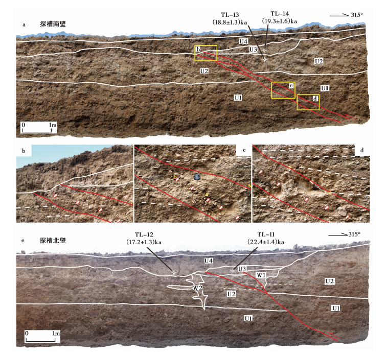
Fig. 3 Trench profile on the west side of the Tiesibahan reservoir.
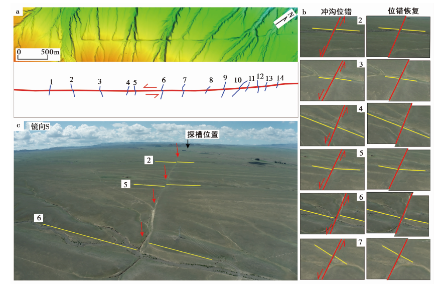
Fig. 4 Horizontal dislocations of gullies in the west branch.
| 编号 | 北纬/(°) | 东经/(°) | 左旋位移量/m | 误差/m |
|---|---|---|---|---|
| 1 | 45.8711 | 83.5360 | 10.0 | -1.2/+1.4 |
| 2 | 45.8725 | 83.5377 | 16.6 | -0.9/+1.0 |
| 3 | 45.8763 | 83.5431 | 24.9 | -2.1/+2.0 |
| 4 | 45.8790 | 83.5474 | 22.5 | -0.9/+0.9 |
| 5 | 45.8802 | 83.5490 | 12.1 | -1.8/+1.3 |
| 6 | 45.8831 | 83.5533 | 32.4 | -2.1/+1.5 |
| 7 | 45.8852 | 83.5563 | 23.3 | -0.7/+0.7 |
| 8 | 45.8881 | 83.5601 | 37.5 | -4.1/+4.1 |
| 9 | 45.8897 | 83.5624 | 31.5 | -4.0/+2.9 |
| 10 | 45.8917 | 83.5650 | 34.7 | -2.0/+2.0 |
| 11 | 45.8923 | 83.5661 | 18.6 | -0.5/+3.4 |
| 12 | 45.8934 | 83.5672 | 20.9 | -1.3/+1.1 |
| 13 | 45.8944 | 83.5684 | 36.7 | -3.9/+1.7 |
| 14 | 45.8954 | 83.5696 | 12.1 | -2.4/+2.5 |
Table1 Statistic result of the horizontal dislocations of the gullies on the T3 of the Kapusheke River
| 编号 | 北纬/(°) | 东经/(°) | 左旋位移量/m | 误差/m |
|---|---|---|---|---|
| 1 | 45.8711 | 83.5360 | 10.0 | -1.2/+1.4 |
| 2 | 45.8725 | 83.5377 | 16.6 | -0.9/+1.0 |
| 3 | 45.8763 | 83.5431 | 24.9 | -2.1/+2.0 |
| 4 | 45.8790 | 83.5474 | 22.5 | -0.9/+0.9 |
| 5 | 45.8802 | 83.5490 | 12.1 | -1.8/+1.3 |
| 6 | 45.8831 | 83.5533 | 32.4 | -2.1/+1.5 |
| 7 | 45.8852 | 83.5563 | 23.3 | -0.7/+0.7 |
| 8 | 45.8881 | 83.5601 | 37.5 | -4.1/+4.1 |
| 9 | 45.8897 | 83.5624 | 31.5 | -4.0/+2.9 |
| 10 | 45.8917 | 83.5650 | 34.7 | -2.0/+2.0 |
| 11 | 45.8923 | 83.5661 | 18.6 | -0.5/+3.4 |
| 12 | 45.8934 | 83.5672 | 20.9 | -1.3/+1.1 |
| 13 | 45.8944 | 83.5684 | 36.7 | -3.9/+1.7 |
| 14 | 45.8954 | 83.5696 | 12.1 | -2.4/+2.5 |
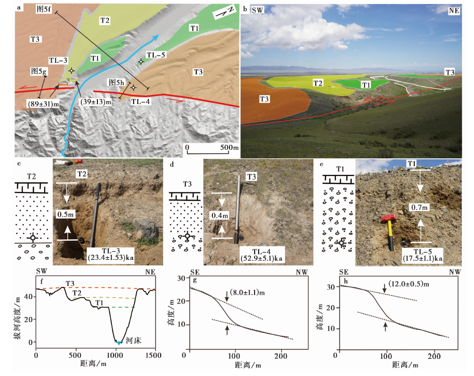
Fig. 5 Fault dislocation on the terrace of the Kapusheke River.
Fig. 6 Fault dislocation on the terrace of the Jiamate River.
| 野外 编号 | 位置 | 北纬 /(°) | 东经 /(°) | 高程 /m | 埋深 /m | U /μg·g-1 | Th /μg·g-1 | K /% | 含水量 /% | 粒径 /μm | 环境剂量率 /Gy·ka-1 | 等效剂量 /Gy | 年龄 /ka | |
|---|---|---|---|---|---|---|---|---|---|---|---|---|---|---|
| TL-3 | 喀普舍克河 | T2 | 45.842 | 83.591 | 1348 | 0.5 | 3.81±0.03 | 10.5±0.06 | 2.04±0.01 | 6.3 | 90~125 | 3.7±0.2 | 86.1±4.5 | 23.4±1.5 |
| TL-4 | T3 | 45.846 | 83.597 | 1349 | 0.4 | 7.06±0.16 | 7.06±0.05 | 1.72±0.01 | 2.6 | 90~125 | 4.0±0.2 | 213.0±18.5 | 52.9±5.1 | |
| TL-5 | T1 | 45.848 | 83.595 | 1327 | 0.7 | 2.34±0.05 | 7.54±0.15 | 2.85±0.03 | 2.6 | 90~125 | 4.1±0.2 | 71.3±3.1 | 17.5±1.1 | |
| TL-6 | 加玛特河 | T2砾石层 | 45.750 | 83.529 | 1459 | 6.5 | 2.41±0.06 | 7.88±0.15 | 3.4±0.01 | 1.2 | 90~125 | 4.6±0.2 | 261.4±5.4 | 57.0±2.9 |
| TL-7 | T2粗砂层 | 45.750 | 83.529 | 1459 | 1.8 | 6.69±0.05 | 11±0.23 | 2.03±0.02 | 5.8 | 90~125 | 4.3±0.2 | 99.3±3.4 | 23.1±1.2 | |
| TL-8 | 坎前堆积 | 45.750 | 83.529 | 1459 | 0.5 | 2.33±0.05 | 9.91±0.06 | 2.79±0.02 | 2.8 | 90~125 | 4.2±0.2 | 33.1±1.8 | 7.9±0.5 | |
| TL-11 | 铁斯巴汗探槽 | 崩积楔 | 45.748 | 83.491 | 1278 | 0.7 | 2.05±0.05 | 7.42±0.06 | 1.64±0.01 | 1.1 | 90~125 | 2.9±0.1 | 64.1±3.0 | 22.4±1.4 |
| TL-12 | 断塞塘 | 45.748 | 83.491 | 1278 | 0.7 | 1.63±0.03 | 5.53±0.12 | 1.64±0.01 | 3.2 | 90~125 | 2.6±0.1 | 44.2±2.7 | 17.2±1.3 | |
| TL-13 | T2 | 45.748 | 83.491 | 1278 | 1.0 | 2.29±0.03 | 7.64±0.05 | 1.77±0.01 | 1.5 | 90~125 | 3.0±0.1 | 57.0±3.1 | 18.8±1.3 | |
| TL-14 | 崩积楔 | 45.748 | 83.491 | 1278 | 0.7 | 1.89±0.02 | 7.07±0.06 | 1.81±0.01 | 3.0 | 90~125 | 2.9±0.1 | 56.0±4.2 | 19.3±1.6 |
Table2 Dating results of the Tuoli Fault
| 野外 编号 | 位置 | 北纬 /(°) | 东经 /(°) | 高程 /m | 埋深 /m | U /μg·g-1 | Th /μg·g-1 | K /% | 含水量 /% | 粒径 /μm | 环境剂量率 /Gy·ka-1 | 等效剂量 /Gy | 年龄 /ka | |
|---|---|---|---|---|---|---|---|---|---|---|---|---|---|---|
| TL-3 | 喀普舍克河 | T2 | 45.842 | 83.591 | 1348 | 0.5 | 3.81±0.03 | 10.5±0.06 | 2.04±0.01 | 6.3 | 90~125 | 3.7±0.2 | 86.1±4.5 | 23.4±1.5 |
| TL-4 | T3 | 45.846 | 83.597 | 1349 | 0.4 | 7.06±0.16 | 7.06±0.05 | 1.72±0.01 | 2.6 | 90~125 | 4.0±0.2 | 213.0±18.5 | 52.9±5.1 | |
| TL-5 | T1 | 45.848 | 83.595 | 1327 | 0.7 | 2.34±0.05 | 7.54±0.15 | 2.85±0.03 | 2.6 | 90~125 | 4.1±0.2 | 71.3±3.1 | 17.5±1.1 | |
| TL-6 | 加玛特河 | T2砾石层 | 45.750 | 83.529 | 1459 | 6.5 | 2.41±0.06 | 7.88±0.15 | 3.4±0.01 | 1.2 | 90~125 | 4.6±0.2 | 261.4±5.4 | 57.0±2.9 |
| TL-7 | T2粗砂层 | 45.750 | 83.529 | 1459 | 1.8 | 6.69±0.05 | 11±0.23 | 2.03±0.02 | 5.8 | 90~125 | 4.3±0.2 | 99.3±3.4 | 23.1±1.2 | |
| TL-8 | 坎前堆积 | 45.750 | 83.529 | 1459 | 0.5 | 2.33±0.05 | 9.91±0.06 | 2.79±0.02 | 2.8 | 90~125 | 4.2±0.2 | 33.1±1.8 | 7.9±0.5 | |
| TL-11 | 铁斯巴汗探槽 | 崩积楔 | 45.748 | 83.491 | 1278 | 0.7 | 2.05±0.05 | 7.42±0.06 | 1.64±0.01 | 1.1 | 90~125 | 2.9±0.1 | 64.1±3.0 | 22.4±1.4 |
| TL-12 | 断塞塘 | 45.748 | 83.491 | 1278 | 0.7 | 1.63±0.03 | 5.53±0.12 | 1.64±0.01 | 3.2 | 90~125 | 2.6±0.1 | 44.2±2.7 | 17.2±1.3 | |
| TL-13 | T2 | 45.748 | 83.491 | 1278 | 1.0 | 2.29±0.03 | 7.64±0.05 | 1.77±0.01 | 1.5 | 90~125 | 3.0±0.1 | 57.0±3.1 | 18.8±1.3 | |
| TL-14 | 崩积楔 | 45.748 | 83.491 | 1278 | 0.7 | 1.89±0.02 | 7.07±0.06 | 1.81±0.01 | 3.0 | 90~125 | 2.9±0.1 | 56.0±4.2 | 19.3±1.6 |
| 断裂 | 位错编号 | 位错来源 | 位错量/m | 样品编号 | 样品年龄/ka | 走滑速率/mm·a-1 |
|---|---|---|---|---|---|---|
| 西支 | T2t | 铁斯巴汗T2阶地坎位错 | 34.0±6.8 | TL-14 | 19.3±1.6 | 1.8±0.5 |
| T2tmin | 铁斯巴汗T2冲沟最大位错 | 25.4±7.0 | TL-12 | 17.2±1.3 | 1.5±0.4 | |
| T3kmin | 喀普舍克T3冲沟最大位错 | 37.5±4.1 | TL-4 | 52.9±5.1 | 0.7±0.2 | |
| 东支 | T3k | 喀普舍克T3阶地坎位错 | 89±31 | TL-4 | 52.9±5.1 | 1.7±0.8 |
| T2k | 喀普舍克T2阶地坎位错 | 39±13 | TL-3 | 23.4±1.5 | 1.7±0.8 | |
| T2jmin | 加玛特T2残留脊位错 | 36±5 | TL-7 | 23.1±1.2 | 1.6±0.4 |
Table3 Calculation of sinistral slip rate of the Tuoli Fault
| 断裂 | 位错编号 | 位错来源 | 位错量/m | 样品编号 | 样品年龄/ka | 走滑速率/mm·a-1 |
|---|---|---|---|---|---|---|
| 西支 | T2t | 铁斯巴汗T2阶地坎位错 | 34.0±6.8 | TL-14 | 19.3±1.6 | 1.8±0.5 |
| T2tmin | 铁斯巴汗T2冲沟最大位错 | 25.4±7.0 | TL-12 | 17.2±1.3 | 1.5±0.4 | |
| T3kmin | 喀普舍克T3冲沟最大位错 | 37.5±4.1 | TL-4 | 52.9±5.1 | 0.7±0.2 | |
| 东支 | T3k | 喀普舍克T3阶地坎位错 | 89±31 | TL-4 | 52.9±5.1 | 1.7±0.8 |
| T2k | 喀普舍克T2阶地坎位错 | 39±13 | TL-3 | 23.4±1.5 | 1.7±0.8 | |
| T2jmin | 加玛特T2残留脊位错 | 36±5 | TL-7 | 23.1±1.2 | 1.6±0.4 |
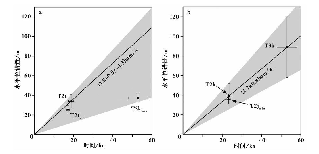
Fig. 7 Sinistral slip rate of the Tuoli Fault.
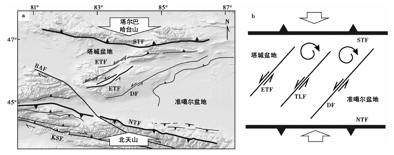
Fig. 8 Regional deformation of the west Junggar area.
| [1] | 陈熠, 方小敏, 宋春晖, 等. 2012. 准噶尔盆地南缘新生代沉积物碎屑锆石记录的天山隆升剥蚀过程[J]. 地学前缘, 19(5): 225233. |
| CHEN Yi, FANG Xiao-min, SONG Chun-hui, et al. 2012. The uplift and erosion of the Tianshan Mountains recorded by detrital zircon geochronology from the Cenozoic sediments in the southern Junggar Basin[J]. Earth Science Frontiers, 19(5): 225233. (in Chinese) | |
| [2] | 高睿, 肖龙, 王国灿, 等. 2013. 西准噶尔晚古生代岩浆活动和构造背景[J]. 岩石学报, 29(10): 34133434. |
| GAO Rui, XIAO Long, WANG Guo-can, et al. 2013. Paleozoic magmatism and tectonic setting in West Junggar[J]. Acta Petrologica Sinica, 29(10): 34133434. (in Chinese) | |
| [3] | 焦光磊, 李永军, 易善鑫, 等. 2013. 西准噶尔由后碰撞向板内体制转变的地质记录: 来自克西克A型花岗岩的证据[J]. 西北地质, 46(3): 3949. |
| JIAO Guang-lei, LI Yong-jun, YI Shan-xin, et al. 2013. The geologic record of the post-collision shift to intraplate system in West Junggar: Evidence from Kexike A-type granite[J]. Northwestern Geology, 46(3): 3949. (in Chinese) | |
| [4] |
李安, 冉勇康, 刘华国, 等. 2016. 西南天山柯坪推覆系西段全新世构造活动特征和古地震[J]. 地球科学进展, 31(4): 377390.
DOI |
|
LI An, RAN Yong-kang, LIU Hua-guo, et al. 2016. Active characteristics and paleoearthquakes in the west Kalpin nappe since the Holocene, SW Tianshan[J]. Advances in Earth Science, 31(4): 377390. (in Chinese)
DOI |
|
| [5] |
李安, 杨晓平, 黄伟亮, 等. 2012. 焉耆盆地北缘和静逆断裂-褶皱带第四纪变形[J]. 地震地质, 34(2): 240253. doi: 10.3969/j.issn.0253-4967.2012.02.004.
DOI |
| LI An, YANG Xiao-ping, HUANG Wei-liang, et al. 2012. Quaternary deformation of the Hejing thrust-fold belt on northern margin of the Yanqi Basin, southern Tianshan[J]. Seismology and Geology, 34(2): 240253. (in Chinese) | |
| [6] | 李传友. 2005. 青藏高原东北部几条主要断裂带的定量研究[D]. 北京: 中国地震局地质研究所. |
| LI Chuan-you. 2005. Quantitative studies on major active fault zones in northeastern Qinghai-Tibet Plateau[D]. Institute of Geology, China Earthquake Administration, Beijing. (in Chinese) | |
| [7] | 李理, 赵利, 钟大赉. 2013. 新生代大陆板内伸展盆-山耦合与大陆碰撞效应: 以渤海湾盆地济阳坳陷、 周缘隆起及边界断裂构造演化为例[J]. 地质科学, 48(2): 406418. |
| LI Li, ZHAO Li, ZHONG Da-lai. 2013. Cenozeic continental intraplate extension basin-mountain coupling and continental collision: Evidences from Bohai Bay Basin, its peripheral mountain and Tancheng-Lujiang Fault[J]. Chinese Journal of Geology, 48(2): 406418. (in Chinese) | |
| [8] | 马晓峰, 王琪, 史基安, 等. 2012. 准噶尔盆地陆西地区石炭二叠系火山岩岩性岩相特征及其对储层的控制[J]. 特种油气藏, 19(1): 5457. |
| MA Xiao-feng, WANG Qi, SHI Ji-an, et al. 2012. Lithologic and lithofacies characteristics of the Carboniferous-Permian volcanic rocks and their control actions on the reservoirs in Luxi area, Junggar Basin[J]. Special Oil & Gas Reservoirs, 19(1): 5457. (in Chinese) | |
| [9] | 马宗晋, 曲国胜, 李涛, 等. 2008. 准噶尔盆地盆山构造耦合与分段性[J]. 新疆石油地质, 29(3): 271277. |
| MA Zong-jin, QU Guo-sheng, LI Tao, et al. 2008. Tectonic coupling and segmentation of marginal structural belt in Junggar Basin[J]. Xinjiang Petroleum Geology, 29(3): 271277. (in Chinese) | |
| [10] | 牛改红, 李孝泽, 王兆云, 等. 2021. 8Ma以来准噶尔盆地西缘白杨河冲-洪积扇ZK1钻孔剖面沉积环境演变[J]. 第四纪研究, 41(6): 15841595. |
| NIU Gai-hong, LI Xiao-ze, WANG Zhao-yun, et al. 2021. Depositional environment evolution of ZK1 drilling section since 8Ma in the Baiyanghe alluvial fan on the west margin of Junggar Basin, NW China[J]. Quaternary Sciences, 41(6): 15841595. (in Chinese) | |
| [11] | 潘家伟, 李海兵, van der Woerd J, 等. 2009. 青藏高原西北部帕米尔东北缘构造地貌与活动构造研究[J]. 第四纪研究, 29(3): 586598. |
| PAN Jia-wei, LI Hai-bing, van der Woerd J, et al. 2009. Tectonic geomorphology and active tectonics in northeastern Pamir, northwest margin of Qinhai-Tibet plateau[J]. Quaternary Sciences, 29(3): 586598. (in Chinese) | |
| [12] | 齐进英. 1993. 新疆准噶尔脉岩群地质及成因[J]. 岩石学报, 9(3): 287299. |
| QI Jin-ying. 1993. Geology and genesis of vein rock group in western Zhunggar, Xinjiang[J]. Acta Petrologica Sinica, 9(3): 287299. (in Chinese) | |
| [13] | 冉勇康, 杨晓平, 程建武, 等. 2006. 西南天山柯坪推覆构造柯坪塔格山前逆断裂东段晚第四纪的古地震[J]. 地震地质, 28(2): 245257. |
| RAN Yong-kang, YANG Xiao-ping, CHENG Jian-wu, et al. 2006. Paleo-earthquakes along the east section of the range front of KalpinTag during late Quaternary in Kalpin structure system, the southwest Tianshan Mountains[J]. Seismology and Geology, 28(2): 245257. (in Chinese) | |
| [14] | 施炜, 刘源, 刘洋, 等. 2013. 青藏高原东北缘海原断裂带新生代构造演化[J]. 地学前缘, 20(4): 117. |
| SHI Wei, LIU Yuan, LIU Yang, et al. 2013. Cenozoic evolution of the Haiyuan fault zone in the northeast margin of the Tibetan plateau[J]. Earth Science Frontiers, 20(4): 117. (in Chinese) | |
| [15] | 宋彪, 李锦轶, 张进, 等. 2011. 西准噶尔托里地区塔尔根二长花岗岩锆石U-Pb年龄托里断裂左行走滑运动开始的时间约束[J]. 地质通报, 30(1): 1925. |
| SONG Biao, LI Jin-yi, ZHANG Jin, et al. 2011. Zircon SHRIMP U-Pb age of Targen monzogranite in western Junggar, Xinjiang, China: Initial time of left-lateral slip of the Tuoli fault[J]. Geological Bulletin of China, 30(1): 1925. (in Chinese) | |
| [16] |
王虎, 冉勇康, 陈立春, 等. 2018. 安宁河断裂带南段滑动速率估计[J]. 地震地质, 40(5): 967979. doi: 10.3969/j.issn.0253-4967.2018.05.002.
DOI |
| WANG Hu, RAN Yong-kang, CHEN Li-chun, et al. 2018. Determination of slip rate on the southern segment of the Anninghe Fault[J]. Seismology and Geology, 40(5): 967979. (in Chinese) | |
| [17] | 汪一鹏, 沈军. 2000. 天山北麓活动构造基本特征[J]. 新疆地质, 18(3): 203210. |
| WANG Yi-peng, SHEN Jun. 2000. Basic features of active structures at the northern foothill of Tianshan Mountains, China[J]. Xinjiang Geology, 18(3): 203210. (in Chinese) | |
| [18] |
吴传勇, 阿里木江, 戴训也, 等. 2014. 西南天山迈丹断裂东段晚第四纪活动的发现及构造意义[J]. 地震地质, 36(4): 976990. doi: 10.3969/j.issn.0253-4967.2014.04.004.
DOI |
| WU Chuan-yong, Alimujiang, DAI Xun-ye, et al. 2014. Discovery of the late-Quaternary activity along the eastern segment of Maidan Fault in southwest Tianshan and its tectonic implication[J]. Seismology and Geology, 36(4): 976990. (in Chinese) | |
| [19] | 许志琴, 王勤, 李忠海, 等. 2016. 印度-亚洲碰撞: 从挤压到走滑的构造转换[J]. 地质学报, 90(1): 123. |
| XU Zhi-qin, WANG Qin, LI Zhong-hai, et al. 2016. Indo-Asian collision: Tectonic transition from compression to strike slip[J]. Acta Geologica Sinica, 90(1): 123. (in Chinese) | |
| [20] | 杨晓平, 邓起东, 张培震, 等. 2008. 天山山前主要推覆构造区的地壳缩短[J]. 地震地质, 30(1): 111131. |
| YANG Xiao-ping, DENG Qi-dong, ZHANG Pei-zhen, et al. 2008. Crustal shortening of major nappe structures on the front margnis of the Tianshan[J]. Seismology and Geology, 30(1): 111131. (in Chinese) | |
| [21] |
姚远, 李帅, 黄帅堂, 等. 2019. 西准噶尔冬别列克断裂晚第四纪以来的阶地位错与滑动速率[J]. 地震地质, 41(4): 803820. doi: 10.3969/j.issn.0253-4967.2019.04.001.
DOI |
| YAO Yuan, LI Shuai, HUANG Shuai-tang, et al. 2019. Terrace deformation and slip rates of the Dongbielieke Fault in western Junggar Basin since the late Quaternary[J]. Seismology and Geology, 41(4): 803820. (in Chinese) | |
| [22] |
姚远, 宋和平, 陈建波, 等. 2018. 新疆天山南部北轮台断裂带晚第四纪活动速率[J]. 地震地质, 40(1): 7186. doi: 10.3969/j.issn.0253-4967.2018.01.006.
DOI |
| YAO Yuan, SONG He-ping, CHEN Jian-bo, et al. 2018. Late Quaternary crustal shortening rate of the Beiluntai Fault in southern Tianshan, Xinjaing[J]. Seismology and Geology, 40(1): 7186. (in Chinese) | |
| [23] | 张会平, 张培震, 郑德文, 等. 2012. 祁连山构造地貌特征: 青藏高原东北缘晚新生代构造变形和地貌演化过程的启示[J]. 第四纪研究, 32(5): 907920. |
| ZHANG Hui-ping, ZHANG Pei-zhen, ZHENG De-wen, et al. 2012. Tectonic geomorphology of the Qilian Shan: Insights into the Late Cenozoic landscape evolution and deformation in the northeastern Tibetan plateau[J]. Quaternary Sciences, 32(5): 907920. (in Chinese) | |
| [24] | 张培震, 邓起东, 杨晓平, 等. 1996. 天山的晚新生代构造变形及其地球动力学问题[J]. 中国地震, 12(2): 127140. |
| ZHANG Pei-zhen, DENG Qi-dong, YANG Xiao-ping, et al. 1996. Late Cenozoic tectonic deformation and mechanism along the Tianshan Mountains, northwestern China[J]. Earthquake Research in China, 12(2): 127140. (in Chinese) | |
| [25] | 张培震, 李传友, 毛凤英. 2008. 河流阶地演化与走滑断裂滑动速率[J]. 地震地质, 30(1): 4457. |
| ZHANG Pei-zhen, LI Chuan-you, MAO Feng-ying. 2008. Strath terrace formation and strike slip faulting[J]. Seismology and geology, 30(1): 4457. (in Chinese) | |
| [26] | 张越迁, 汪新, 刘继山, 等. 2011. 准噶尔盆地西北缘乌夏走滑构造及油气勘探意义[J]. 新疆石油地质, 32(5): 447450. |
| ZHANG Yue-qian, WANG Xin, LIU Ji-shan, et al. 2011. Wuerhe-Xiazijie strike-slip structure and petroleum exploration significance in northwestern margin of Junggar Basin[J]. Xinjiang Petroleum Geology, 32(5): 447450. (in Chinese) | |
| [27] |
Axen G J. 1988. The geometry of planar domino-style normal faults above a dipping basal detachment[J]. Journal of Structural Geology, 10(4): 405411.
DOI URL |
| [28] |
Cowgill E. 2007. Impact of riser reconstructions on estimation of secular variation in rates of strike-slip faulting: Revisiting the Cherchen River site along the Altyn Tagh Fault, NW China[J]. Earth and Planetary Science Letters, 254(3): 239255.
DOI URL |
| [29] |
Ding W C, Li T D, Chen X H, et al. 2019. Intra-continental deformation and tectonic evolution of the west Junggar orogenic belt, Central Asia: Evidence from remote sensing and structural geological analyses[J]. Geoscience Frontiers, 11(2): 651663.
DOI URL |
| [30] | Molnar P H, Tapponnier P. 1975. Cenozoic tectonics of Asia: Effects of a continental collision[J]. Nature, 189(4201): 419426. |
| [31] |
Nixon C W, Sanderson D J, Bull J M. 2011. Deformation with a strike-slip fault network at Westward Ho!, Devon U K: Domino vs conjugate faulting[J]. Journal of Structural Geology, 33(5): 833843.
DOI URL |
| [32] |
Nur A, Ron H, Scotti O. 1986. Fault mechanics and the kinematics of block rotations[J]. Geology, 14(9): 746749.
DOI URL |
| [33] |
Tapponnier P, Peltzer G, Dain A Y L, et al. 1982. Propagating extrusion tectonics in Asia: New insights from simple experiments with plasticine[J]. Geology, 10(12): 611616.
DOI URL |
| [34] | Yang G, Wang X, Li B, et al. 2011. Transpression and wrench faults of northwestern margin of Junggar Basin[J]. Chinese Journal of Geology, 46(3): 696708. |
| [35] |
Yao Y, Li S, Huang S T, et al. 2020. Late Quaternary activity characteristics of the strike-slip Dongbielieke Fault in West Junggar, China[J]. Arabian Journal of Geosciences, 13(11): 115.
DOI |
| [36] | Yu J X, Walker R T, Rhodes E J, et al. 2021. East Tacheng(Qoqek)fault zone: Late Quaternary tectonics and slip rate of a left-lateral strike-slip fault zone north of the Tian Shan[J]. Tectonics, 40(2): e2020TC006377. |
| [37] |
Zhang P, Wang G, Shen T, et al. 2021. Paleozoic convergence processes in the southwestern central Asian orogenic belt: Insights from U-Pb dating of detrital zircons from West Junggar, northwestern China[J]. Geoscience Frontiers, 12(2): 531548.
DOI URL |
| [38] | Zhao R, Li J, Shi S, et al. 1997. Structural activity of middle Daerbute Fault[J]. Inland Earthquake, 11(4): 295301. |
| [1] | CHANG Yu-qiao, ZHANG Hui-ping, ZHAO Xu-dong. RESEARCH ADVANCES OF THE LATE QUATERNARY ACTIVITY OF XIAOJIANG FAULT ZONE IN THE SOUTHEASTERN MARGIN OF QINGHAI-XIZANG PLATEAU [J]. SEISMOLOGY AND GEOLOGY, 2026, 48(2): 279-313. |
| [2] | XU Wei, LI Guang-tao, CHENG Li, ZOU Zi-nan. LATE QUATERNARY ACTIVITY CHARACTERISTICS IN THE SHIBAN RIVER TO NANNIWAN SEGMENT OF THE SOUTHERN MAOMAOSHAN MARGINAL FAULT [J]. SEISMOLOGY AND GEOLOGY, 2026, 48(2): 386-402. |
| [3] | LUO Jia-xin, LI Bin, LI Zi-hong, FAN Kun. CHARACTERISTICS OF VERTICAL SLIP RATE EVOLUTION ALONG THE JIAOCHENG FAULT ZONE, SHANXI, SINCE LATE PLEISTOCENE [J]. SEISMOLOGY AND GEOLOGY, 2026, 48(1): 43-63. |
| [4] | CHEN Yan-wen, YUAN Dao-yang, YAO Yun-sheng, YU Jin-chao, WEN Ya-meng, SU Rui-huan, SUN Hao. CHARACTERISTICS OF LATE QUATERNARY ACTIVITY AND TECTONIC IMPLICATIONS OF THE MAYAXUESHAN FAULT IN THE EASTERN QILIAN SHAN [J]. SEISMOLOGY AND GEOLOGY, 2025, 47(6): 1566-1585. |
| [5] | GAO Yang, WU Zhong-hai, HAN Shuai, TIAN Ting-ting. LATE QUATERNARY THROW RATE OF THE SEISMOGENIC FAULT(DENGMECUO FAULT)OF THE 2025 MS6.8 DINGRI EARTHQUAKE IN SHIGATSE [J]. SEISMOLOGY AND GEOLOGY, 2025, 47(3): 689-706. |
| [6] | WANG Duo, CHEN Li-chun, LI Yan-bao, WANG Hu, JIA Yong-shun, GAO Yin-yi, XUE Ke-yi. LATE QUATERNARY ACTIVITY OF THE XIETONGMEN TO DENGMECUO SEGMENT ALONG THE XAINZA-DINGGYE RIFT IN SOUTHERN QINGHAI-XIZANG PLATEAU [J]. SEISMOLOGY AND GEOLOGY, 2025, 47(3): 718-733. |
| [7] | CHEN Chang-yun, YIN Hai-quan. CRUSTAL DEFORMATION CHARACTERISTICS AND PROBABILITY PREDICTION OF STRONG EARTHQUAKE RISK IN XINJIANG AND ITS ADJACENT REGION [J]. SEISMOLOGY AND GEOLOGY, 2025, 47(2): 384-404. |
| [8] | ZHU Shuang, GUO Nan-nan, PANG Ya-jin. STUDY ON FAULT DEFORMATION CHARACTERISTICS AND SEISMIC HAZARD IN THE KEPING THRUST BELT [J]. SEISMOLOGY AND GEOLOGY, 2025, 47(2): 448-462. |
| [9] | XU Bin-bin, ZHANG Yi-peng, LU Le-jun, TIAN Qing-ying, YANG Xue, WANG Yang, ZHANG Pei-zhen. STUDY ON SEISMOGENIC TECTONICS OF THE 2025 MYANMAR MS7.9 EARTHQUAKE [J]. SEISMOLOGY AND GEOLOGY, 2025, 47(2): 649-670. |
| [10] | ZANG Ke-zhi, WU Chuan-yong, ZHANG Jin-shuo, GAO Zhan, YUAN Si-hua, YUAN Hai-yang, YU Xiao-hui, WANG Xue-zhu. LATE QUATERNARY DEFORMATION RATE OF THE WENSU FORELAND THRUST BELT IN THE SOUTHERN TIANSHAN MOUNTAINS [J]. SEISMOLOGY AND GEOLOGY, 2024, 46(6): 1280-1294. |
| [11] | HUA Chun-yu, SHI Feng, WEI Zhan-yu. STUDY ON THE SLIP RATE OF THE BAISHA RIVER SEGMENT IN THE YINGXIU-BEICHUAN FAULT IN THE LONGMENSHAN FAULT ZONE [J]. SEISMOLOGY AND GEOLOGY, 2024, 46(6): 1295-1313. |
| [12] | CHEN Bai-xu, YU Zhong-yuan, XIAO Peng, DAI Xun-ye, ZHANG Shi-long, ZHENG Rong-ying. THE NEW FINDINGS OF SURFACE RUPTURE ZONES AND ITS SEISMOLOGICAL SIGNIFICANCE OF THE EASTERN MARGIN OF YUMUSHAN FAULT, NORTHEASTERN MARGIN OF QINGZANG PLATEAU [J]. SEISMOLOGY AND GEOLOGY, 2024, 46(3): 589-607. |
| [13] | HUANG Wei-liang, ZHANG Jia-le, XIANG Wen, YANG Qian-hao. THE LATE QUATERNARY ACTIVITY CHARACTERISTICS AND SLIP RATE OF BATANG FAULT IN SE TIBETAN PLATEAU [J]. SEISMOLOGY AND GEOLOGY, 2023, 45(6): 1265-1285. |
| [14] | CHEN Yi, ZHAO Bin, XIONG Wei, WANG Wei, YU Peng-fei, YU Jian-sheng, WANG Dong-zhen, CHEN Wei, QIAO Xue-jun. INTERSEISMIC SLIP RATES AND SHALLOW CREEP ALONG THE NORTHWESTERN SEGMENT OF THE XIANSHUIHE FAULT FROM INSAR DATA [J]. SEISMOLOGY AND GEOLOGY, 2023, 45(5): 1074-1091. |
| [15] | LIU Qing, LIU Shao, ZHANG Shi-min. PALEOSEISMOLOGIC STUDY ON THE YUEXI FAULT IN THE MIDSECTION OF THE DALIANGSHAN FAULT ZONE SINCE THE LATE QUATERNARY [J]. SEISMOLOGY AND GEOLOGY, 2023, 45(2): 321-337. |
| Viewed | ||||||
|
Full text |
|
|||||
|
Abstract |
|
|||||
Copyright © SEISMOLOGY AND GEOLOGY, All Rights Reserved.
Tel: 010-62009049/9063 E-mail: dzdz@ies.ac.cn
Powered by Beijing Magtech Co., Ltd.