
SEISMOLOGY AND GEOLOGY ›› 2025, Vol. 47 ›› Issue (6): 1566-1585.DOI: 10.3969/j.issn.0253-4967.2025.06.20240052
Previous Articles Next Articles
CHARACTERISTICS OF LATE QUATERNARY ACTIVITY AND TECTONIC IMPLICATIONS OF THE MAYAXUESHAN FAULT IN THE EASTERN QILIAN SHAN
CHEN Yan-wen1)( ), YUAN Dao-yang1),*(), YAO Yun-sheng2), YU Jin-chao1), WEN Ya-meng1), SU Rui-huan1), SUN Hao1)
- 1) School of Earth Sciences, Lanzhou University, Lanzhou 730000, China
2) Lanzhou Institute of Geotechnique and Earthquake, China Earthquake Administration, Lanzhou 730000, China
-
Received:2024-04-16Revised:2024-08-06Online:2025-12-20Published:2025-12-31
祁连山东段玛雅雪山断裂晚第四纪活动特征及其构造意义
陈艳文1)(), 袁道阳1),*(), 姚赟胜2), 于锦超1), 文亚猛1), 苏瑞欢1), 孙浩1)
- 1) 兰州大学, 地质科学与矿产资源学院, 兰州 730000
2) 中国地震局兰州岩土地震研究所, 兰州 730000
-
通讯作者:*袁道阳, 男, 1965年生, 教授, 博士生导师, 主要从事新构造、 活动构造及历史地震研究, E-mail: yuandy@lzu.edu.cn。 -
作者简介:陈艳文, 男, 1992年生, 现为兰州大学地质学专业在读博士研究生, 主要从事新构造与活动构造研究, E-mail: chenyw2023@lzu.edu.cn。
-
基金资助:第二次青藏高原综合科学考察研究(2019QZKK0901); 国家自然科学基金(42172227)
Cite this article
CHEN Yan-wen, YUAN Dao-yang, YAO Yun-sheng, YU Jin-chao, WEN Ya-meng, SU Rui-huan, SUN Hao. CHARACTERISTICS OF LATE QUATERNARY ACTIVITY AND TECTONIC IMPLICATIONS OF THE MAYAXUESHAN FAULT IN THE EASTERN QILIAN SHAN[J]. SEISMOLOGY AND GEOLOGY, 2025, 47(6): 1566-1585.
陈艳文, 袁道阳, 姚赟胜, 于锦超, 文亚猛, 苏瑞欢, 孙浩. 祁连山东段玛雅雪山断裂晚第四纪活动特征及其构造意义[J]. 地震地质, 2025, 47(6): 1566-1585.
share this article
Add to citation manager EndNote|Ris|BibTeX
URL: https://www.dzdz.ac.cn/EN/10.3969/j.issn.0253-4967.2025.06.20240052
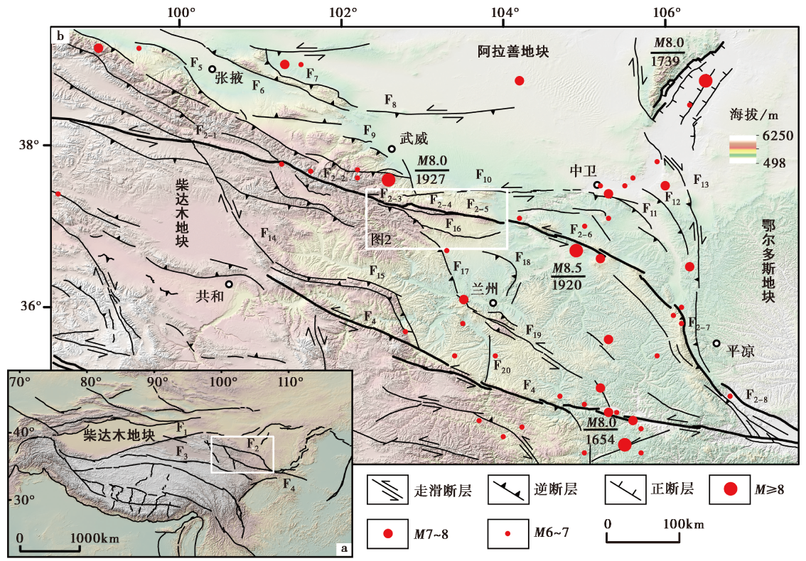
Fig. 1 Active tectonics in the northeastern Tibetan plateau.
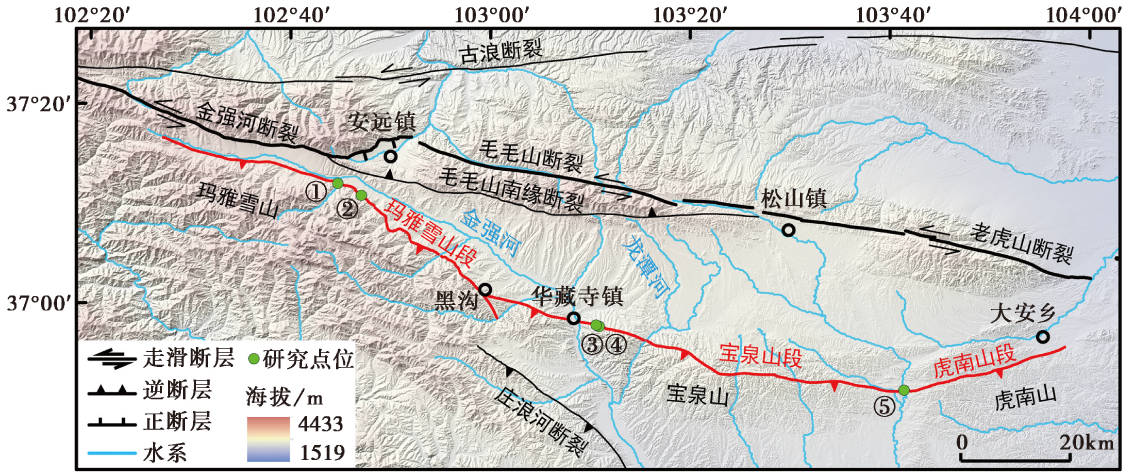
Fig. 2 The spatial distribution of Mayaxueshan Fault.
| 样品 编号 | 采样深度 /m | 含水量 /% | U /ppm | Th /ppm | K /% | 等效剂量 /Gy | 环境剂量率 /Gy·ka-1 | 年龄 /a |
|---|---|---|---|---|---|---|---|---|
| OSL-2 | 0.95 | 9.85 | 2.47±0.02 | 13.5±0.18 | 2.59±0.01 | 42.99±1.9 | 3.99±0.04 | 10765±485 |
| OSL-3 | 0.6 | 25.39 | 2.61±0.02 | 14.15±0.04 | 2.41±0.01 | 30.49±3.13 | 3.94±0.04 | 6275±795 |
| OSL-4 | 1.3 | 28.84 | 2.59±0.03 | 13.24±0.17 | 2.27±0.03 | 55.72±3.31 | 3.71±0.05 | 15020±915 |
| OSL-5 | 0.3 | 18.17 | 2.49±0.10 | 11.53±0.53 | 2.34±0.02 | 12.97±1.59 | 3.7±0.06 | 3500±430 |
| OSL-6 | 0.2 | 7.77 | 2.3±0.02 | 11.36±0.13 | 2.13±0.01 | 42.46±1.2 | 3.49±0.04 | 12160±370 |
| OSL-7 | 0.3 | 5.32 | 2.78±0.03 | 13.24±0.12 | 2.06±0.02 | 47.06±1.62 | 3.84±0.06 | 12255±450 |
| OSL-8 | 0.7 | 2.89 | 2.46±0.03 | 11.69±0.12 | 2.12±0.03 | 55.76±1.23 | 3.64±0.05 | 15305±390 |
Table1 The results of optically stimulated luminescence(OSL) dating along the Mayaxueshan Fault
| 样品 编号 | 采样深度 /m | 含水量 /% | U /ppm | Th /ppm | K /% | 等效剂量 /Gy | 环境剂量率 /Gy·ka-1 | 年龄 /a |
|---|---|---|---|---|---|---|---|---|
| OSL-2 | 0.95 | 9.85 | 2.47±0.02 | 13.5±0.18 | 2.59±0.01 | 42.99±1.9 | 3.99±0.04 | 10765±485 |
| OSL-3 | 0.6 | 25.39 | 2.61±0.02 | 14.15±0.04 | 2.41±0.01 | 30.49±3.13 | 3.94±0.04 | 6275±795 |
| OSL-4 | 1.3 | 28.84 | 2.59±0.03 | 13.24±0.17 | 2.27±0.03 | 55.72±3.31 | 3.71±0.05 | 15020±915 |
| OSL-5 | 0.3 | 18.17 | 2.49±0.10 | 11.53±0.53 | 2.34±0.02 | 12.97±1.59 | 3.7±0.06 | 3500±430 |
| OSL-6 | 0.2 | 7.77 | 2.3±0.02 | 11.36±0.13 | 2.13±0.01 | 42.46±1.2 | 3.49±0.04 | 12160±370 |
| OSL-7 | 0.3 | 5.32 | 2.78±0.03 | 13.24±0.12 | 2.06±0.02 | 47.06±1.62 | 3.84±0.06 | 12255±450 |
| OSL-8 | 0.7 | 2.89 | 2.46±0.03 | 11.69±0.12 | 2.12±0.03 | 55.76±1.23 | 3.64±0.05 | 15305±390 |
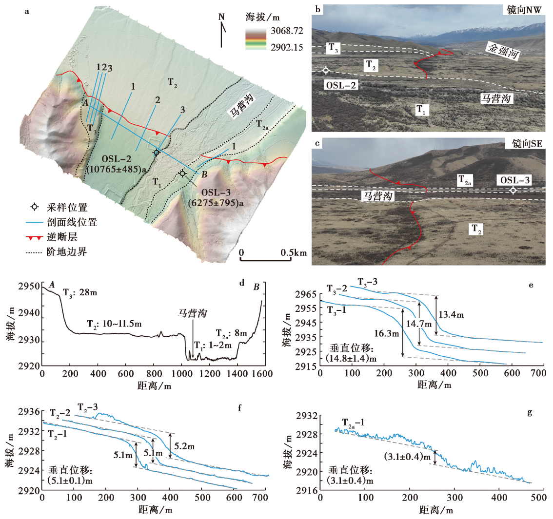
Fig. 3 Terrace classification and fault scarp features of Mayaxueshan segment the Mayaxueshan Fault at Mayinggou.
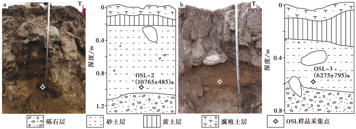
Fig. 4 Sections of the OSL dating sample collection on the terraces in Mayinggou.
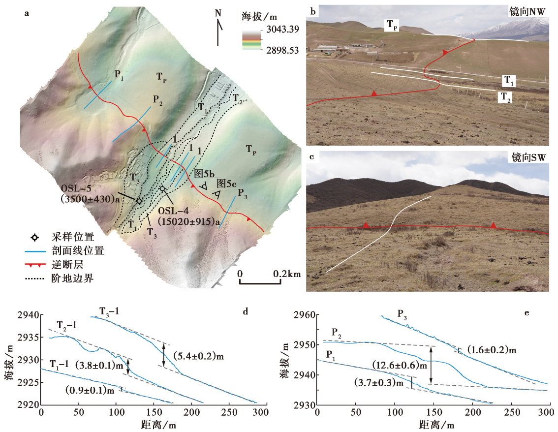
Fig. 5 Faulted geomorphology features of Mayaxueshan segment the Mayaxueshan Fault at Shangbacigou.
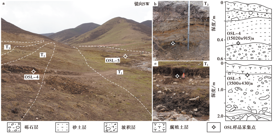
Fig. 6 Sections of the OSL dating sample collection in Shangbacigou.
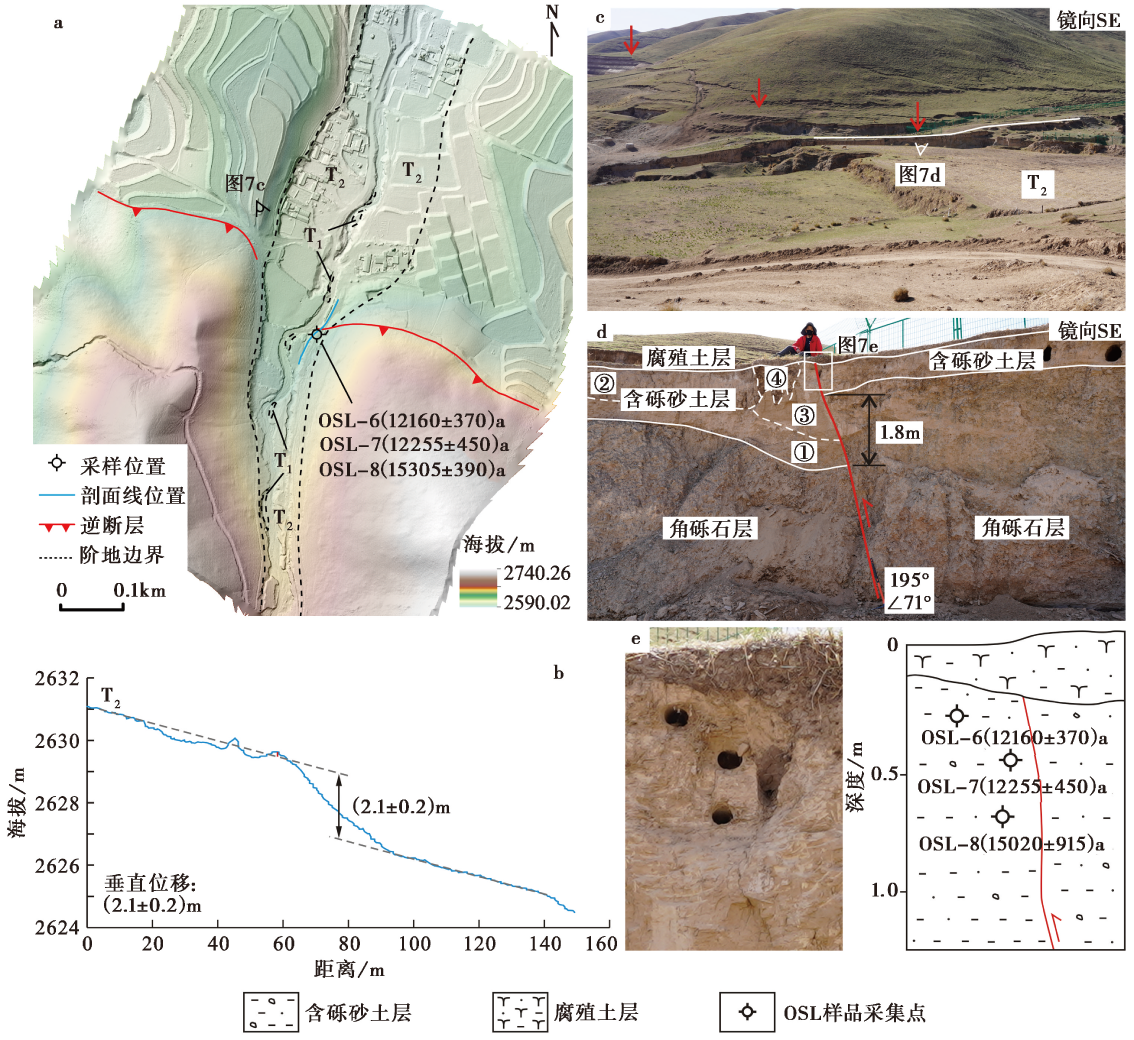
Fig. 7 Faulted geomorphology and fault features of Baoquanshan segment the Mayaxueshan Fault at Dajiayao.
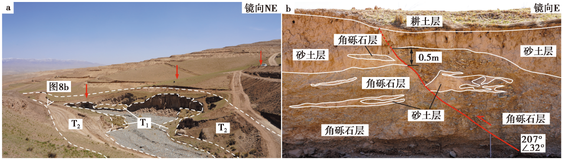
Fig. 8 Faulted geomorphology and fault features of Baoquanshan segment the Mayaxueshan Fault at Jiaqianggou.
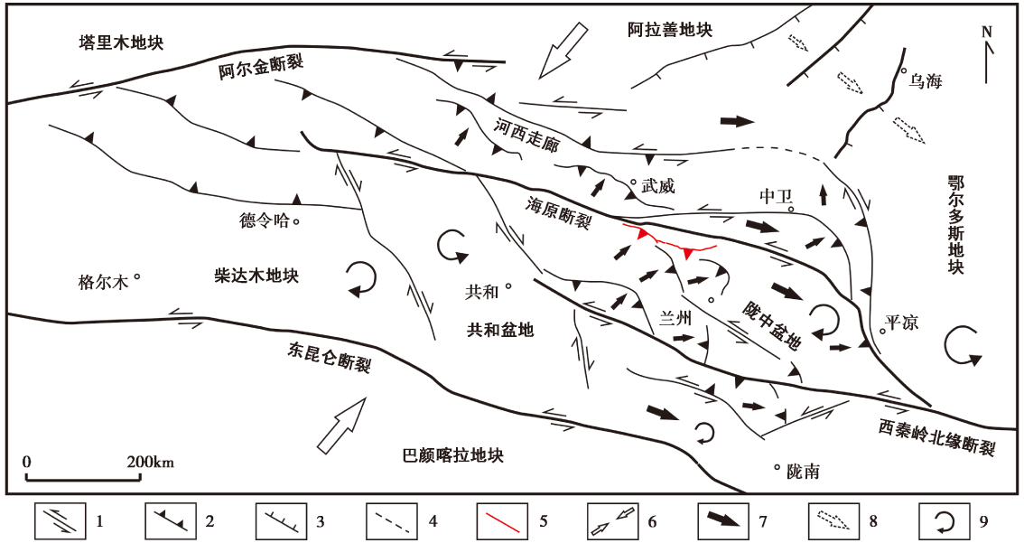
Fig. 9 Tectonic deformation model in northeastern margin of the Tibetan plateau.
| [1] |
陈文彬, 徐锡伟. 2006. 阿拉善地块南缘的左旋走滑断裂与阿尔金断裂带的东延[J]. 地震地质, 28(2): 319-324. doi: 10.3969/j.issn.0253-4967.2006.02.015.
|
|
|
|
| [2] |
崔浇. 2023. 陇中盆地内部活动断裂及其动力学分析[D]. 兰州: 中国地震局兰州地震研究所: 21-27.
|
|
|
|
| [3] |
邓起东, 于贵华, 叶文华. 1992. 地震地表破裂参数与震级关系的研究 G//国家地震局地质研究所编. 活动断裂研究, (2): 247-264.
|
|
|
|
| [4] |
冯兵, 郝明, 张志朋, 等. 2022. 青藏高原东北缘及其周边地区现今构造应力场及地震活动性[J]. 大地测量与地球动力学, 42(10): 1067-1073.
|
|
|
|
| [5] |
高伟. 2018. 天桥沟-黄羊川断裂晚第四纪活动特征及其构造意义[D]. 北京: 中国地震局地质研究所: 110-112.
|
|
|
|
| [6] |
国家地震局地质研究所, 宁夏回族自治区地震局. 1990. 海原活动断裂带[M]. 北京: 地震出版社.
|
|
Institute of Geology, State Seismological Bureau,
|
|
| [7] |
国家地震局兰州地震研究所, 甘肃省计划委员会. 1993. 甘肃省地震危险区划研究[M]. 兰州: 兰州大学出版社: 46-47.
|
|
Lanzhou Institute of Seismology, State Seismological Bureau,
|
|
| [8] |
雷启云, 张培震, 郑文俊, 等. 2017. 贺兰山西麓断裂右旋走滑的地质地貌证据及其构造意义[J]. 地震地质, 39(6): 1297-1315. doi: 10.3969/j.issn.0253-4967.2017.06.014.
|
|
DOI |
|
| [9] |
李新男, 李传友, 张培震, 等. 2016. 香山-天景山断裂带西段的运动性质变化及其成因机制[J]. 地震地质, 38(3): 732-746. doi: 10.3969/j.issn.0253-4967.2016.03.018.
|
|
DOI |
|
| [10] |
李智敏, 李延京, 田勤俭, 等. 2014. 拉脊山断裂古地震与喇家遗址灾变事件关系研究[J]. 地震研究, 37(S1): 109-115.
|
|
|
|
| [11] |
陆诗铭, 吴中海, 李智超. 2024. 2023年12月18日甘肃省积石山6.2级地震的控震构造及特征[J]. 地震科学进展, 54(1): 86-93.
|
|
|
|
| [12] |
闵伟. 1998. 区域古地震研究--以青藏高原东北缘和华北西缘为例[D]. 北京: 中国地震局地质研究所: 20-22.
|
|
|
|
| [13] |
苏琦, 袁道阳, 谢虹. 2017. 祁连山东段石羊河流域及邻区地貌特征及其构造意义[J]. 地质论评, 63(1): 7-20.
|
|
|
|
| [14] |
向宏发, 虢顺民, 张秉良, 等. 1998. 六盘山东麓活动逆断裂构造带晚第四纪以来的活动特征[J]. 地震地质, 20(4): 321-327.
|
|
|
|
| [15] |
徐锡伟, 李峰, 程佳, 等. 2023. 活动断层研究进展及其科学前沿问题讨论[J]. 煤田地质与勘探, 51(12): 1-16.
|
|
|
|
| [16] |
俞晶星. 2016. 阿拉善地块南部构造活动及其对周边地块相互作用的响应[D]. 北京: 中国地震局地质研究所: 98-99.
|
|
|
|
| [17] |
袁道阳, 刘百篪, 才树华, 等. 2002a. 兰州马衔山北缘断裂带的新活动特征[J]. 地震地质, 24(3): 315-323.
|
|
|
|
| [18] |
袁道阳, 刘百篪, 张培震, 等. 2002b. 兰州庄浪河断裂带的新构造变形与地震活动[J]. 地震学报, 24(4): 441-444, 448.
|
|
|
|
| [19] |
袁道阳, 张培震, 刘百篪, 等. 2004. 青藏高原东北缘晚第四纪活动构造的几何图像与构造转换[J]. 地质学报, 78(2): 270-278.
|
|
|
|
| [20] |
袁道阳, 张培震, 雷中生, 等. 2005. 青海拉脊山断裂带新活动特征的初步研究[J]. 中国地震, 21(1): 93-102.
|
|
|
|
| [21] |
张波. 2012. 西秦岭北缘断裂西段与拉脊山断裂新活动特征研究[D]. 兰州: 中国地震局兰州地震研究所: 94-96.
|
|
|
|
| [22] |
张培震, 邓起东, 张国民, 等. 2003. 中国大陆的强震活动与活动地块[J]. 中国科学(D辑), 33(S1): 12-20.
|
|
|
|
| [23] |
张瑞, 张竹琪, 郑德文, 等. 2021. 鄂尔多斯活动地块西缘强震间库仑应力作用[J]. 地球物理学报, 64(10): 3576-3599.
DOI |
|
|
|
| [24] |
张维岐, 焦德成, 柴炽章, 等. 1988. 宁夏香山-天景山弧形断裂带新活动特征及1709年中卫南 7½级地震形变带[J]. 地震地质, 10(3): 12-20.
|
|
|
|
| [25] |
赵凌强, 詹艳, 王庆良, 等. 2018. 1954年甘肃民勤7级地震区深部电性结构特征及地震构造环境研究[J]. 地震地质, 40(3): 552-565. doi: 10.3969/j.issn.0253-4967.2018.03.004.
|
|
DOI |
|
| [26] |
郑文俊, 张竹琪, 张培震, 等. 2013. 1954年山丹 7¼级地震的孕震构造和发震机制探讨[J]. 地球物理学报, 56(3): 916-928.
|
|
|
|
| [27] |
郑文俊, 袁道阳, 张培震, 等. 2016. 青藏高原东北缘活动构造几何图像、 运动转换与高原扩展[J]. 第四纪研究, 36(4): 775-788.
|
|
|
|
| [28] |
郑文俊, 王庆良, 袁道阳, 等. 2020. 活动地块假说理论框架的提出、 发展及未来需关注的科学问题[J]. 地震地质, 42(2): 245-270. doi: 10.3969/j.issn.0253-4967.2020.02.001.
|
|
DOI |
|
| [29] |
郑文俊, 张博譞, 袁道阳, 等. 2021. 阿拉善地块南缘构造活动特征与青藏高原东北缘向外扩展的最新边界[J]. 地球科学与环境学报, 43(2): 224-236.
|
|
|
|
| [30] |
周德敏, 甘卫军, 任金卫, 等. 2005. 基于GPS观测资料反演庄浪河断裂带、 马衔山北缘断裂带的滑动速率[J]. 地震地质, 27(4): 706-714.
|
|
|
|
| [31] |
DOI URL |
| [32] |
DOI URL |
| [33] |
DOI URL |
| [34] |
|
| [35] |
DOI URL |
| [36] |
|
| [37] |
DOI URL |
| [38] |
|
| [39] |
DOI URL |
| [40] |
|
| [41] |
|
| [42] |
|
| [43] |
|
| [44] |
|
| [45] |
DOI URL |
| [46] |
PMID |
| [47] |
DOI URL |
| [48] |
|
| [49] |
DOI URL |
| [50] |
|
| [51] |
DOI URL |
| [52] |
DOI URL |
| [53] |
|
| [54] |
DOI URL |
| [55] |
DOI URL |
| [56] |
DOI URL |
| [57] |
DOI URL |
| [1] | CHANG Yu-qiao, ZHANG Hui-ping, ZHAO Xu-dong. RESEARCH ADVANCES OF THE LATE QUATERNARY ACTIVITY OF XIAOJIANG FAULT ZONE IN THE SOUTHEASTERN MARGIN OF QINGHAI-XIZANG PLATEAU [J]. SEISMOLOGY AND GEOLOGY, 2026, 48(2): 279-313. |
| [2] | XU Wei, LI Guang-tao, CHENG Li, ZOU Zi-nan. LATE QUATERNARY ACTIVITY CHARACTERISTICS IN THE SHIBAN RIVER TO NANNIWAN SEGMENT OF THE SOUTHERN MAOMAOSHAN MARGINAL FAULT [J]. SEISMOLOGY AND GEOLOGY, 2026, 48(2): 386-402. |
| [3] | LUO Jia-xin, LI Bin, LI Zi-hong, FAN Kun. CHARACTERISTICS OF VERTICAL SLIP RATE EVOLUTION ALONG THE JIAOCHENG FAULT ZONE, SHANXI, SINCE LATE PLEISTOCENE [J]. SEISMOLOGY AND GEOLOGY, 2026, 48(1): 43-63. |
| [4] | GAO Yang, WU Zhong-hai, HAN Shuai, TIAN Ting-ting. LATE QUATERNARY THROW RATE OF THE SEISMOGENIC FAULT(DENGMECUO FAULT)OF THE 2025 MS6.8 DINGRI EARTHQUAKE IN SHIGATSE [J]. SEISMOLOGY AND GEOLOGY, 2025, 47(3): 689-706. |
| [5] | WANG Duo, CHEN Li-chun, LI Yan-bao, WANG Hu, JIA Yong-shun, GAO Yin-yi, XUE Ke-yi. LATE QUATERNARY ACTIVITY OF THE XIETONGMEN TO DENGMECUO SEGMENT ALONG THE XAINZA-DINGGYE RIFT IN SOUTHERN QINGHAI-XIZANG PLATEAU [J]. SEISMOLOGY AND GEOLOGY, 2025, 47(3): 718-733. |
| [6] | CHEN Chang-yun, YIN Hai-quan. CRUSTAL DEFORMATION CHARACTERISTICS AND PROBABILITY PREDICTION OF STRONG EARTHQUAKE RISK IN XINJIANG AND ITS ADJACENT REGION [J]. SEISMOLOGY AND GEOLOGY, 2025, 47(2): 384-404. |
| [7] | ZHU Shuang, GUO Nan-nan, PANG Ya-jin. STUDY ON FAULT DEFORMATION CHARACTERISTICS AND SEISMIC HAZARD IN THE KEPING THRUST BELT [J]. SEISMOLOGY AND GEOLOGY, 2025, 47(2): 448-462. |
| [8] | XU Bin-bin, ZHANG Yi-peng, LU Le-jun, TIAN Qing-ying, YANG Xue, WANG Yang, ZHANG Pei-zhen. STUDY ON SEISMOGENIC TECTONICS OF THE 2025 MYANMAR MS7.9 EARTHQUAKE [J]. SEISMOLOGY AND GEOLOGY, 2025, 47(2): 649-670. |
| [9] | HUA Chun-yu, SHI Feng, WEI Zhan-yu. STUDY ON THE SLIP RATE OF THE BAISHA RIVER SEGMENT IN THE YINGXIU-BEICHUAN FAULT IN THE LONGMENSHAN FAULT ZONE [J]. SEISMOLOGY AND GEOLOGY, 2024, 46(6): 1295-1313. |
| [10] | CHEN Bai-xu, YU Zhong-yuan, XIAO Peng, DAI Xun-ye, ZHANG Shi-long, ZHENG Rong-ying. THE NEW FINDINGS OF SURFACE RUPTURE ZONES AND ITS SEISMOLOGICAL SIGNIFICANCE OF THE EASTERN MARGIN OF YUMUSHAN FAULT, NORTHEASTERN MARGIN OF QINGZANG PLATEAU [J]. SEISMOLOGY AND GEOLOGY, 2024, 46(3): 589-607. |
| [11] | HUANG Wei-liang, ZHANG Jia-le, XIANG Wen, YANG Qian-hao. THE LATE QUATERNARY ACTIVITY CHARACTERISTICS AND SLIP RATE OF BATANG FAULT IN SE TIBETAN PLATEAU [J]. SEISMOLOGY AND GEOLOGY, 2023, 45(6): 1265-1285. |
| [12] | CHEN Yi, ZHAO Bin, XIONG Wei, WANG Wei, YU Peng-fei, YU Jian-sheng, WANG Dong-zhen, CHEN Wei, QIAO Xue-jun. INTERSEISMIC SLIP RATES AND SHALLOW CREEP ALONG THE NORTHWESTERN SEGMENT OF THE XIANSHUIHE FAULT FROM INSAR DATA [J]. SEISMOLOGY AND GEOLOGY, 2023, 45(5): 1074-1091. |
| [13] | YUAN Hao-dong, LI An, HUANG Wei-liang, HU Zong-kai, ZUO Yu-qi, YANG Xiao-ping. GEOLOGICAL DEFORMATION OF THE TUOLI FAULT IN THE WEST JUNGGAR SINCE THE LATE QUATERNARY [J]. SEISMOLOGY AND GEOLOGY, 2023, 45(1): 49-66. |
| [14] | YANG Yuan-yuan, LI Peng-fei, LU Shuo, SHU Peng, PAN Hao-bo, FANG Liang-hao, ZHENG Hai-gang, ZHAO Peng, ZHENG Ying-ping, YAO Da-quan. PALEOEARTHQUAKES AND VERTICAL SLIP RATES ON THE HUAI RIVER-NÜSHAN LAKE SEGMENT OF FAULT F5 IN THE MIDDLE SECTION OF THE TANLU FAULT ZONE [J]. SEISMOLOGY AND GEOLOGY, 2022, 44(6): 1365-1383. |
| [15] | ZHANG Xiu-li, XIONG Jian-guo, ZHANG Pei-zhen, LIU Qing-ri, YAO Yong, ZHONG Yue-zhi, ZHANG Hui-ping, LI You-li. STUDY ON THE SLIP RATE OF THE NORTH ZHONGTIAO SHAN FAULT SINCE THE LATE MIDDLE PLEISTOCENE [J]. SEISMOLOGY AND GEOLOGY, 2022, 44(6): 1403-1420. |
| Viewed | ||||||
|
Full text |
|
|||||
|
Abstract |
|
|||||
Copyright © SEISMOLOGY AND GEOLOGY, All Rights Reserved.
Tel: 010-62009049/9063 E-mail: dzdz@ies.ac.cn
Powered by Beijing Magtech Co., Ltd.