
SEISMOLOGY AND GEOLOGY ›› 2026, Vol. 48 ›› Issue (3): 774-796.DOI: 10.3969/j.issn.0253-4967.20240078
• Research paper • Previous Articles Next Articles
DEEP STRUCTURAL CHARACTERISTIC OF MAJOR FAULTS IN THE JIN-JI-MENG BOUNDARY AREA BASED ON BOUGUER GRAVITY DATA
LUO Xiang-fei( ), LI Zhong-liang, WANG Ze-yuan, YU Bo, JI Ji-fa*(), HAO Peng-fei, LIU Dong-yang, HE Wei-min
Geophysical Exploration Center ,China Earthquake Administration
-
Received:2025-06-12Revised:2025-11-26Online:2026-06-20Published:2026-07-09
基于布格重力资料研究晋冀蒙交界区主要断裂的深部构造特征
罗翔飞(), 李忠良, 王泽源, 于博, 姬计法*(), 郝鹏飞, 刘冬阳, 贺为民
中国地震局地球物理勘探中心
-
通讯作者:*姬计法, 男, 1970年生, 高级工程师, 主要从事重力测量、反射地震探测方法及应用、活动断层探测与研究, E-mail: JIJF@163.com。 -
作者简介:罗翔飞, 女, 1972年生, 高级工程师, 研究方向为重力监测与地震预报研究, E-mail: luoxf@gec.ac.cn。
-
基金资助:地球深部探测与矿产资源勘查国家科技重大专项(2024ZD1000100); 中国地震局地震行业科技专项(102152210360000000015)

Cite this article
LUO Xiang-fei, LI Zhong-liang, WANG Ze-yuan, YU Bo, JI Ji-fa, HAO Peng-fei, LIU Dong-yang, HE Wei-min. DEEP STRUCTURAL CHARACTERISTIC OF MAJOR FAULTS IN THE JIN-JI-MENG BOUNDARY AREA BASED ON BOUGUER GRAVITY DATA[J]. SEISMOLOGY AND GEOLOGY, 2026, 48(3): 774-796.
罗翔飞, 李忠良, 王泽源, 于博, 姬计法, 郝鹏飞, 刘冬阳, 贺为民. 基于布格重力资料研究晋冀蒙交界区主要断裂的深部构造特征[J]. 地震地质, 2026, 48(3): 774-796.
share this article
Add to citation manager EndNote|Ris|BibTeX
URL: https://www.dzdz.ac.cn/EN/10.3969/j.issn.0253-4967.20240078

Fig. 1 Geological structure map of the study area(Modification of geological structure according to MapSIS and DENG Qi-dong et al., 2007).
| 编号 | 断裂名称 | 性质 | 长度 /km | 产状 | 最新活 动时代 | 和断裂有关历史地震 | ||||
|---|---|---|---|---|---|---|---|---|---|---|
| 走向 | 倾向 | 倾角/(°) | ||||||||
| F1 | 岱海北缘 | 正断层 | 60 | NE | 55 | Qh | 发生过4~5级地震 | |||
| F2 | 岱海南缘 | 正断层 | 75 | NE | 40~55 | Qh | ||||
| F3 | 庙东营-大营滩 | 正断层 | 30 | NW | NW | Qp3 | 与NE向大满-前黑沙土断裂交会处发生1998年张北6.2级地震 | |||
| F4 | 张家口 | 正断层 | 40 | NW | W | 60 | Qp3 | |||
| F5 | 怀安盆地北缘 | 正断层 | 43 | NE、NEE | NNE | 50~75 | Qh | 1968年在怀安发生6¼级地震 | ||
| F6 | 天镇-阳高 | 右旋正走滑 | 80 | NE | SE | 65~75 | Qh | 1673年天镇发生6½级地震 | ||
| F7 | 口泉 | 右旋正断 | 108 | NNE | SE | 60~80 | Qh | 1022年和1305年在断裂南段发生2次6½级地震 | ||
| F8 | 水峪 | 正断层 | 22 | NNE | <30~80 | Qp3 | ||||
| F9 | 采凉山东麓 | 正断层 | 30 | NE | <50~75 | Qh | 沿断裂有小地震活动 | |||
| F10 | 怀安镇盆地南缘 | 正断层 | 41 | EW | 50~75 | Qp3 | ||||
| F11 | 阳原盆地北缘 | 正断层 | 62 | NE | 50~70 | Qp3 | ||||
| F12 | 怀涿盆地北缘 | 正断层 | 58 | NEE | SSE | 50~75 | Qh | 发生多次5级以上地震 | ||
| F13 | 桑干河 | 正断层 | 32 | NEE | NW | 60~65 | Qp3 | |||
| F14 | 新保安-沙城 | 正断层 | 32 | NW | SW | 50~76 | Qp3—Qh | 1972年发生6¾级地震 | ||
| F15 | 延矾盆地北缘 | 正断层 | 102 | NNE、NE | SE | 50~80 | Qh | 1337年狼山发生6½级地震 | ||
| F16 | 六棱山北麓 | 正断层 | 140 | NEE、NE | NNE | 60~80 | Qh | 1989年大同发生6.1级地震和该断层活动有关 | ||
| F17 | 蔚广盆地南缘 | 正断层 | 120 | NE、NEE | NW | 50~70 | Qh | |||
| F18 | 孙庄子-乌龙沟 | 正走滑 | 120 | NNE | NW | 60~70 | Qp3 | |||
| F19 | 沿河城-紫荆关 | 正断层 | 115 | NE | SE、NE | 50~70 | Qp2 | |||
| F20 | 恒山北麓 | 正断层 | 160 | NE | NW | 60~70 | Qh | |||
| F21 | 恒山南麓 | 正走滑断层 | 35-40 | NE | SE | 陡 | Qp3 | |||
| F22 | 五台山北麓 | 正断层 | 85 | NE、NEE | NW | 50~70 | Qh | 512年代县发生7½级地震 | ||
| F23 | 太白山山前 | 正断层 | 32 | NE、NEE | 陡 | Qh | 1626年灵丘发生7级地震 | |||
| F24 | 五台山西麓 | 右旋正走滑 | 40 | NE | NWW | 陡 | Qp3—Qh | 1683年原平发生7级地震 | ||
| F25 | 系舟山北麓 | 正断层 | 100 | NE | NW | 60 | Qh | 1038年在断裂西段定襄发生7¼级地震和2次5级地震 | ||
| F26 | 黄庄-高丽营 | 正断层 | 130 | NE | NNE、NE | 55~75 | Qp3 | |||
| F27 | 系舟山西麓 | 右旋正走滑 | 10 | NNE | NW | 70 | Qh | |||
| F28 | 大满-前黑沙土 | 130 | NE | Qp3 | 1998年张北发生6.2级地震 | |||||
| F29 | 无名断裂 | 300 | NE | NNE | 55~75 | Qp2—Qp3 | ||||
Table1 Main fault characteristics in the study area
| 编号 | 断裂名称 | 性质 | 长度 /km | 产状 | 最新活 动时代 | 和断裂有关历史地震 | ||||
|---|---|---|---|---|---|---|---|---|---|---|
| 走向 | 倾向 | 倾角/(°) | ||||||||
| F1 | 岱海北缘 | 正断层 | 60 | NE | 55 | Qh | 发生过4~5级地震 | |||
| F2 | 岱海南缘 | 正断层 | 75 | NE | 40~55 | Qh | ||||
| F3 | 庙东营-大营滩 | 正断层 | 30 | NW | NW | Qp3 | 与NE向大满-前黑沙土断裂交会处发生1998年张北6.2级地震 | |||
| F4 | 张家口 | 正断层 | 40 | NW | W | 60 | Qp3 | |||
| F5 | 怀安盆地北缘 | 正断层 | 43 | NE、NEE | NNE | 50~75 | Qh | 1968年在怀安发生6¼级地震 | ||
| F6 | 天镇-阳高 | 右旋正走滑 | 80 | NE | SE | 65~75 | Qh | 1673年天镇发生6½级地震 | ||
| F7 | 口泉 | 右旋正断 | 108 | NNE | SE | 60~80 | Qh | 1022年和1305年在断裂南段发生2次6½级地震 | ||
| F8 | 水峪 | 正断层 | 22 | NNE | <30~80 | Qp3 | ||||
| F9 | 采凉山东麓 | 正断层 | 30 | NE | <50~75 | Qh | 沿断裂有小地震活动 | |||
| F10 | 怀安镇盆地南缘 | 正断层 | 41 | EW | 50~75 | Qp3 | ||||
| F11 | 阳原盆地北缘 | 正断层 | 62 | NE | 50~70 | Qp3 | ||||
| F12 | 怀涿盆地北缘 | 正断层 | 58 | NEE | SSE | 50~75 | Qh | 发生多次5级以上地震 | ||
| F13 | 桑干河 | 正断层 | 32 | NEE | NW | 60~65 | Qp3 | |||
| F14 | 新保安-沙城 | 正断层 | 32 | NW | SW | 50~76 | Qp3—Qh | 1972年发生6¾级地震 | ||
| F15 | 延矾盆地北缘 | 正断层 | 102 | NNE、NE | SE | 50~80 | Qh | 1337年狼山发生6½级地震 | ||
| F16 | 六棱山北麓 | 正断层 | 140 | NEE、NE | NNE | 60~80 | Qh | 1989年大同发生6.1级地震和该断层活动有关 | ||
| F17 | 蔚广盆地南缘 | 正断层 | 120 | NE、NEE | NW | 50~70 | Qh | |||
| F18 | 孙庄子-乌龙沟 | 正走滑 | 120 | NNE | NW | 60~70 | Qp3 | |||
| F19 | 沿河城-紫荆关 | 正断层 | 115 | NE | SE、NE | 50~70 | Qp2 | |||
| F20 | 恒山北麓 | 正断层 | 160 | NE | NW | 60~70 | Qh | |||
| F21 | 恒山南麓 | 正走滑断层 | 35-40 | NE | SE | 陡 | Qp3 | |||
| F22 | 五台山北麓 | 正断层 | 85 | NE、NEE | NW | 50~70 | Qh | 512年代县发生7½级地震 | ||
| F23 | 太白山山前 | 正断层 | 32 | NE、NEE | 陡 | Qh | 1626年灵丘发生7级地震 | |||
| F24 | 五台山西麓 | 右旋正走滑 | 40 | NE | NWW | 陡 | Qp3—Qh | 1683年原平发生7级地震 | ||
| F25 | 系舟山北麓 | 正断层 | 100 | NE | NW | 60 | Qh | 1038年在断裂西段定襄发生7¼级地震和2次5级地震 | ||
| F26 | 黄庄-高丽营 | 正断层 | 130 | NE | NNE、NE | 55~75 | Qp3 | |||
| F27 | 系舟山西麓 | 右旋正走滑 | 10 | NNE | NW | 70 | Qh | |||
| F28 | 大满-前黑沙土 | 130 | NE | Qp3 | 1998年张北发生6.2级地震 | |||||
| F29 | 无名断裂 | 300 | NE | NNE | 55~75 | Qp2—Qp3 | ||||
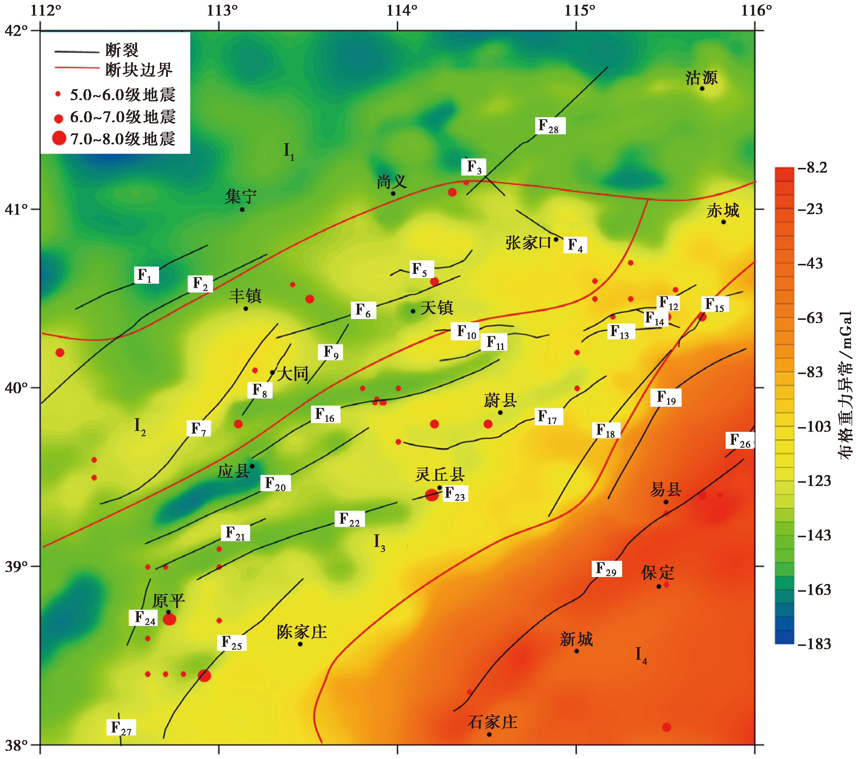
Fig. 2 Distribution of MS≥5 earthquakes, Bouguer gravity anomaly and main faults (Block boundaries are from DENG Qi-dong et al., 2009).
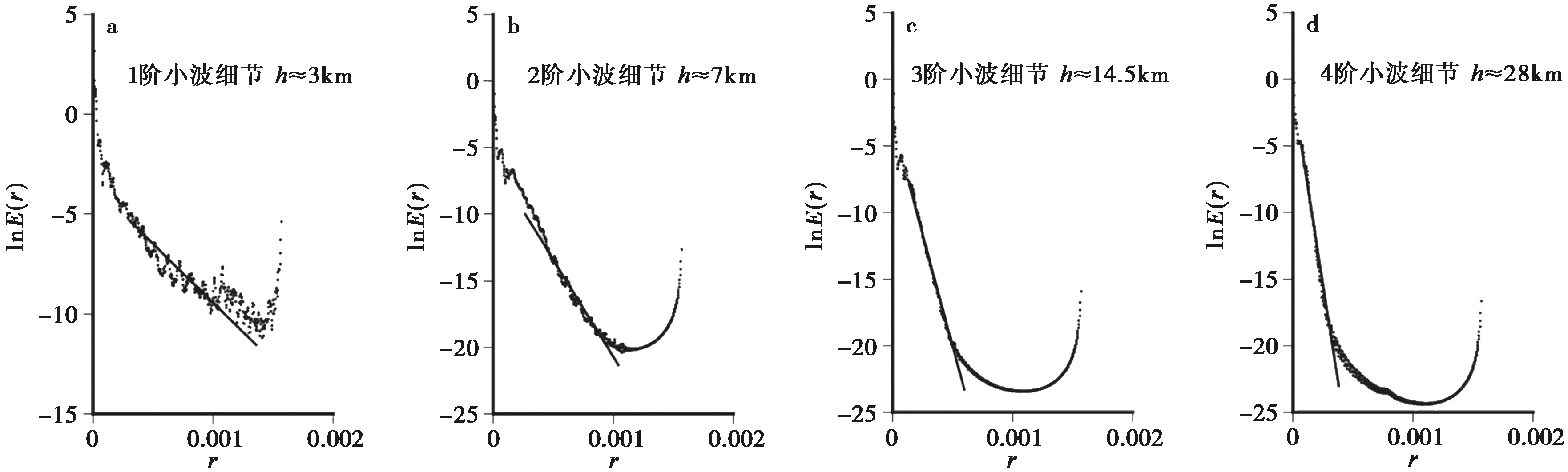
Fig. 3 The radial power spectrum corresponding to the wavelet details.
| 阶次 | 似场源深度/km |
|---|---|
| 1阶细节 | 2~4 |
| 2阶细节 | 7~9 |
| 3阶细节 | 13~16 |
| 4阶细节 | 25~29 |
Table2 Each level of detail represents to the depth of the field source
| 阶次 | 似场源深度/km |
|---|---|
| 1阶细节 | 2~4 |
| 2阶细节 | 7~9 |
| 3阶细节 | 13~16 |
| 4阶细节 | 25~29 |
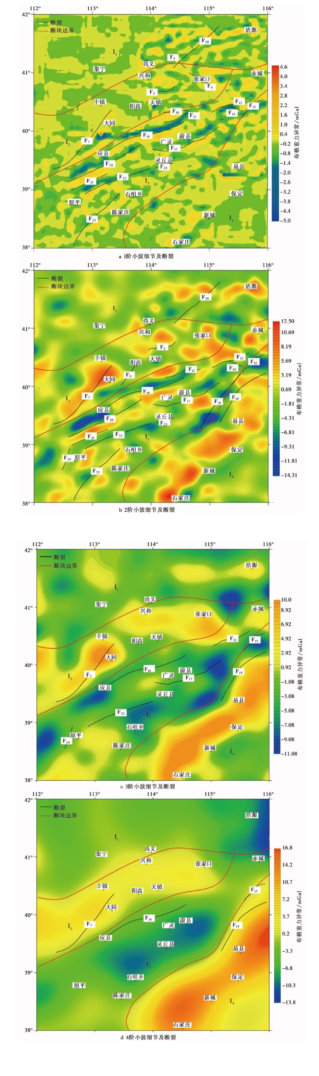
Fig. 4 Analytical results on wavelet multiscale decomposition of Bouguer gravity anomalies and faults.
| 编号 | 断裂名称 | 断裂判断依据 | 切割深度 | |
|---|---|---|---|---|
| 重力场 | 地震剖面(DSS) | |||
| F1 | 岱海北缘 | |||
| F2 | 岱海南缘 | |||
| F3 | 庙东营-大营滩 | 1阶异常轴的水平错动 | 上地壳 | |
| F4 | 张家口 | 1阶异常轴的水平错动 | 上地壳 | |
| F5 | 怀安盆地北缘 | 1、2阶异常线性梯度带 | 上地壳 | |
| F6 | 天镇-阳高 | 中地壳(刘宝峰等, | ||
| F7 | 口泉中南段 | 中南段1~4阶两侧异常特征明显不同的分界线 | 中南段 下地壳 | 下地壳(段永红等, |
| 口泉中北段 | 北段无明显特征 | |||
| F8 | 水峪 | |||
| F9 | 采凉山东麓 | 2阶狭长异常带 | 上地壳 | |
| F10 | 怀安镇盆地南缘 | 1阶线性梯度带 | 上地壳 | |
| F11 | 阳原盆地北缘 | 1、2阶异常轴的水平错动、异常的线性过渡带 | 上地壳 | |
| F12 | 怀涿盆地北缘 | 1~3阶线性过渡带 | 中地壳 | |
| F13 | 桑干河 | 中地壳(刘宝峰等, | ||
| F14 | 新保安-沙城 | 1、2阶等值线的扭曲 | 上地壳 | |
| F15 | 延矾盆地北缘 | 1~4阶线性梯度带、两侧异常明显不同的分界线 | 下地壳 | |
| F16 | 六棱山北麓 | 1~4阶异常线性过渡带 | 下地壳 | 下地壳(张成科等, |
| F17 | 蔚广盆地南缘 | 1~3阶异常轴的水平错动、异常的线性过渡带 | 中地壳 | 中地壳(刘宝峰等, |
| F18 | 孙庄子-乌龙沟 | 2阶线性过渡带或异常带 | 上地壳 | 上地壳(张成科等, |
| F19 | 沿河城-紫荆关 | 2~4阶两侧异常特征明显不同的分界线 | 下地壳 | 下地壳(张成科等, |
| F20 | 恒山北麓 | 1、2阶异常线性过渡带 | 上地壳 | 上地壳(段永红等, |
| F21 | 恒山南麓 | 1、2阶异常线性过渡带 | 上地壳 | 上地壳(段永红等, |
| F22 | 五台山北麓 | 1~3阶异常线性过渡带、异常轴的水平错动 | 中地壳 | 中地壳(段永红等, |
| F23 | 太白山山前 | 1、2阶异常线性过渡带 | 上地壳 | |
| F24 | 五台山西麓 | 2、3阶异常线性过渡带 | 中地壳 | |
| F25 | 系舟山北麓 | 1、2阶异常线性过渡带、异常轴的水平错动 | 上地壳 | 上地壳(段永红等, |
| F26 | 黄庄-高丽营 | |||
| F27 | 系舟山西麓 | |||
| F28 | 大满-前黑沙土 | 1、2阶异常线性过渡带、异常轴的水平错动 | 上地壳 | |
| F29 | 无名断裂 | |||
Table3 Fault analysis result
| 编号 | 断裂名称 | 断裂判断依据 | 切割深度 | |
|---|---|---|---|---|
| 重力场 | 地震剖面(DSS) | |||
| F1 | 岱海北缘 | |||
| F2 | 岱海南缘 | |||
| F3 | 庙东营-大营滩 | 1阶异常轴的水平错动 | 上地壳 | |
| F4 | 张家口 | 1阶异常轴的水平错动 | 上地壳 | |
| F5 | 怀安盆地北缘 | 1、2阶异常线性梯度带 | 上地壳 | |
| F6 | 天镇-阳高 | 中地壳(刘宝峰等, | ||
| F7 | 口泉中南段 | 中南段1~4阶两侧异常特征明显不同的分界线 | 中南段 下地壳 | 下地壳(段永红等, |
| 口泉中北段 | 北段无明显特征 | |||
| F8 | 水峪 | |||
| F9 | 采凉山东麓 | 2阶狭长异常带 | 上地壳 | |
| F10 | 怀安镇盆地南缘 | 1阶线性梯度带 | 上地壳 | |
| F11 | 阳原盆地北缘 | 1、2阶异常轴的水平错动、异常的线性过渡带 | 上地壳 | |
| F12 | 怀涿盆地北缘 | 1~3阶线性过渡带 | 中地壳 | |
| F13 | 桑干河 | 中地壳(刘宝峰等, | ||
| F14 | 新保安-沙城 | 1、2阶等值线的扭曲 | 上地壳 | |
| F15 | 延矾盆地北缘 | 1~4阶线性梯度带、两侧异常明显不同的分界线 | 下地壳 | |
| F16 | 六棱山北麓 | 1~4阶异常线性过渡带 | 下地壳 | 下地壳(张成科等, |
| F17 | 蔚广盆地南缘 | 1~3阶异常轴的水平错动、异常的线性过渡带 | 中地壳 | 中地壳(刘宝峰等, |
| F18 | 孙庄子-乌龙沟 | 2阶线性过渡带或异常带 | 上地壳 | 上地壳(张成科等, |
| F19 | 沿河城-紫荆关 | 2~4阶两侧异常特征明显不同的分界线 | 下地壳 | 下地壳(张成科等, |
| F20 | 恒山北麓 | 1、2阶异常线性过渡带 | 上地壳 | 上地壳(段永红等, |
| F21 | 恒山南麓 | 1、2阶异常线性过渡带 | 上地壳 | 上地壳(段永红等, |
| F22 | 五台山北麓 | 1~3阶异常线性过渡带、异常轴的水平错动 | 中地壳 | 中地壳(段永红等, |
| F23 | 太白山山前 | 1、2阶异常线性过渡带 | 上地壳 | |
| F24 | 五台山西麓 | 2、3阶异常线性过渡带 | 中地壳 | |
| F25 | 系舟山北麓 | 1、2阶异常线性过渡带、异常轴的水平错动 | 上地壳 | 上地壳(段永红等, |
| F26 | 黄庄-高丽营 | |||
| F27 | 系舟山西麓 | |||
| F28 | 大满-前黑沙土 | 1、2阶异常线性过渡带、异常轴的水平错动 | 上地壳 | |
| F29 | 无名断裂 | |||

Fig. 5 The 4th-order wavelet approximation.
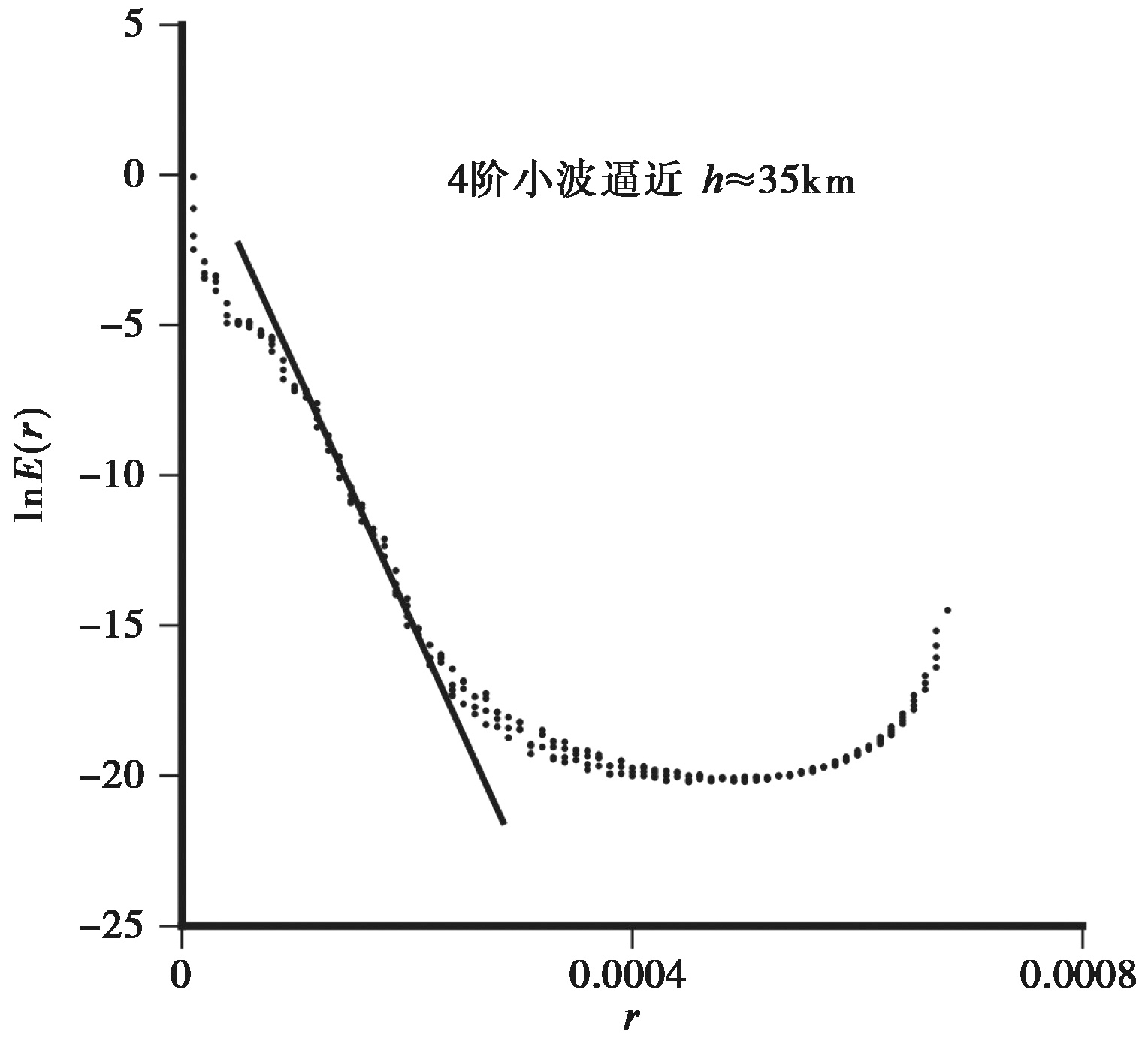
Fig. 6 The 4th-order wavelet approximation of radial power spectrum.
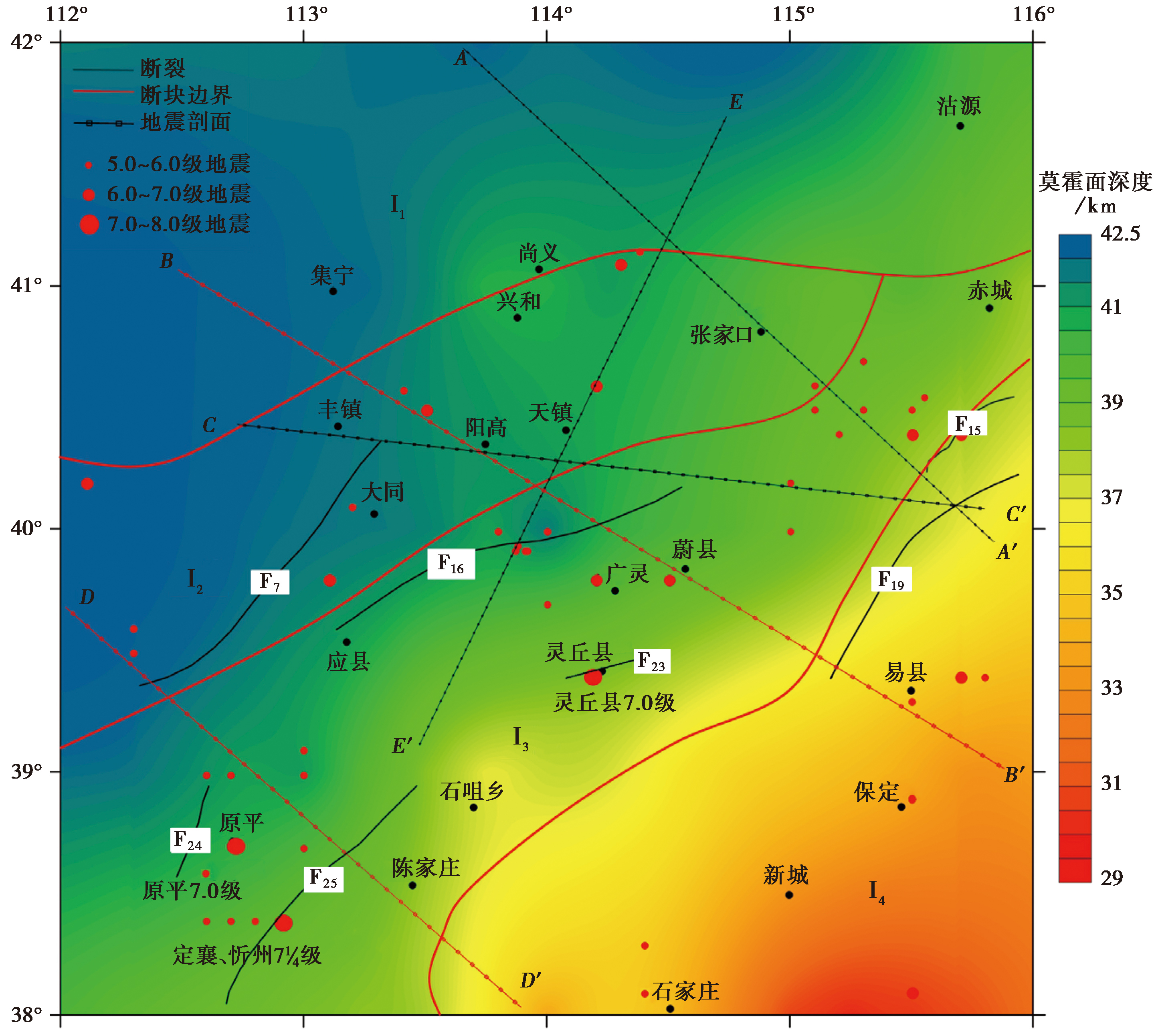
Fig. 7 Moho depth distribution in the study area.
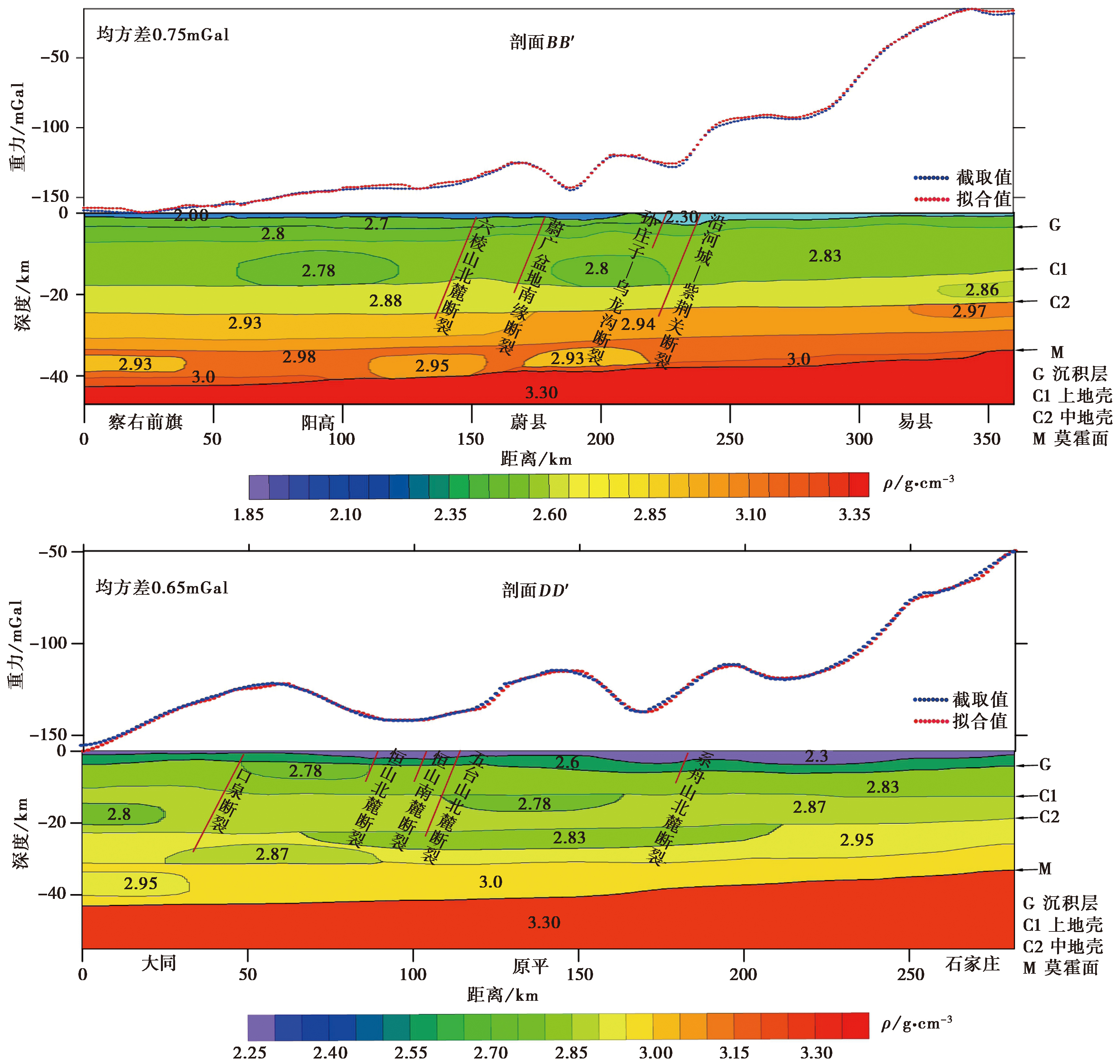
Fig. 8 Profile showing density structure of the study area.
| [1] |
陈大业, 王秀文. 1991. 应用模糊模式识别研究晋冀蒙交界区的中强地震[J]. 山西地震, (4): 6-8.
|
|
|
|
| [2] |
陈绍绪, 张跃刚, 乔子云, 等. 2003. 晋冀蒙交界地区主要断裂的现今活动[J]. 华北地震科学, 21(2): 16-22.
|
|
|
|
| [3] |
陈石, 王谦身, 徐伟民, 等. 2011. 华北地区热均衡、重力均衡与深部构造[J]. 地球物理学报, 54(11): 2864-2875.
|
|
|
|
| [4] |
邓起东, 程绍平, 马冀, 等. 2014. 青藏高原地震活动特征及当前地震活动形势[J]. 地球物理学报, 57(7): 2025-2042.
DOI |
|
|
|
| [5] |
邓起东, 高翔, 杨虎. 2009. 断块构造、活动断块构造与地震活动[J]. 地质科学, 44(4): 1083-1093.
|
|
|
|
| [6] |
邓起东, 冉勇康, 杨晓平, 等. 2007. 中国活动构造图[CM]. 北京: 地震出版社.
|
|
|
|
| [7] |
丁学文, 霍魁, 冯凯宇, 等. 2021. 口泉断裂郊城段断裂展布特征及其活动性研究[J]. 山西地震, (1): 15-19.
|
|
|
|
| [8] |
段瑞涛, 方仲景. 1995. 六棱山北麓断裂新活动特征[J]. 地震地质, 17(3): 207-213.
|
|
|
|
| [9] |
段永红, 刘保金, 赵金仁, 等. 2015. 华北构造区岩石圈二维P波速度结构特征: 来自盐城-包头深地震测深剖面的约束[J]. 中国科学(地球科学), 45(8): 1183-1197.
|
|
|
|
| [10] |
段永红, 王夫运, 张先康, 等. 2016. 华北克拉通中东部地壳三维速度结构模型(HBCrust1.0)[J]. 中国科学(地球科学), 46(6): 845-856.
|
|
|
|
| [11] |
冯锐, 严惠芬, 张若水. 1986. 三维位场的快速反演方法及程序设计[J]. 地质学报, (4): 390-403.
|
|
|
|
| [12] |
高立新, 戴勇. 2012. 晋冀蒙交界地区地震活动性特征分析[J]. 华北地震科学, 30(3): 34-39.
|
|
|
|
| [13] |
关小平. 1991. 利用Parker公式反演界面的一种有效方法[J]. 物探化探计算技术, 13(3): 236-242.
|
|
|
|
| [14] |
韩梅, 张春灌, 李想, 等. 2022. 利用重磁资料研究楚科奇边缘地构造特征[J]. 地球物理学进展, 37(3): 945-951.
|
|
|
|
| [15] |
韩月萍, 杨国华, 塔拉, 等. 2007. 首都圈及晋冀蒙交界地区地壳垂直形变及地震危险性分析[J]. 山西地震, (3): 7-10.
|
|
|
|
| [16] |
侯遵泽, 杨文采. 1997. 中国重力异常的小波变换与多尺度分析[J]. 地球物理学报, 40(1): 85-95.
|
|
|
|
| [17] |
黄福明, 李群芳, 高忠宁. 1991. 北京以西至晋冀蒙交界地区的应力场[J]. 地震学报, 13(3): 307-318.
|
|
|
|
| [18] |
贾晓辉, 李皓, 李姜, 等. 2016. 张家口西部山区农村民居抗震性能调查与分析[J]. 地震工程学报, 32(S1): 128-133.
|
|
|
|
| [19] |
雷晓东, 戚帮申, 关伟, 等. 2021. 北京平原区断裂构造重力异常识别研究[J]. 地球物理学报, 64(4): 1253-1265.
DOI |
|
|
|
| [20] |
李长波, 王良书, 孙斌. 2014. 松辽盆地布格重力异常小波多尺度分解与解释[J]. 高校地质学报, 20(2): 268-276.
|
|
|
|
| [21] |
李成立, 谢春临, 吕庆田. 1998. 利用位场功率谱计算地质体顶底深度效果[J]. 大庆石油地质与开发, 17(5): 45-48.
|
|
|
|
| [22] |
李世雄. 1992. 小波变换及其应用[J]. 地球物理学进展, 7(2): 45-53.
|
|
|
|
| [23] |
刘宝峰, 张先康, 张成科, 等. 2000. 华北文安-蔚县-察哈尔右翼中旗剖面S波资料的地质解释[J]. 地震地质, 22(1): 81-88.
|
|
|
|
| [24] |
路晓翠, 张景发, 朱鲁, 等. 2012. 利用小波多尺度分解研究郯庐断裂带苏鲁段构造[J]. 地球物理学进展, 27(1): 58-67.
|
|
|
|
| [25] |
罗翔飞, 李忠良, 李勇江, 等. 2023. 宜川-泰安剖面的密度结构、构造特征和地震活动[J]. 地震地质, 45(6): 1385-1399. doi: 10.3969/j.issn.0253-4967.2023.06.008.
|
|
DOI |
|
| [26] |
马秀红, 曹继平, 董晟飞. 2003. 小波分析及其应用[J]. 微机发展, 13(8): 93-100.
|
|
|
|
| [27] |
宁亚灵, 吕海杰, 王鹏伟. 2022. 晋冀蒙交界地区地电阻率变化与震兆特征研究[J]. 山西地震, (4): 1-5.
|
|
|
|
| [28] |
王谦身, 滕吉文, 张永谦, 等. 2016. 陕渝黔桂1 800km超长探测剖面重力异常场特征及深部地壳结构探榷[J]. 地球物理学报, 59(11): 4139-4152.
DOI |
|
|
|
| [29] |
王若柏, 毛银海. 1989. 晋冀蒙交界地区的垂直形变研究及其构造活动特征[J]. 地震学刊, 9(4): 130-134.
|
|
|
|
| [30] |
吴桂桔, 谈洪波, 孙凯, 等. 2020. 贺兰山-银川地堑及邻区重力异常特征及构造意义[J]. 地球物理学报, 63(3): 1002-1013.
DOI |
|
|
|
| [31] |
杨文采, 施志群, 侯遵泽, 等. 2001. 离散小波变换与重力异常多重分解[J]. 地球物理学报, 44(4): 534-541.
|
|
|
|
| [32] |
杨学立, 周树亮, 高宝龙, 等. 2016. 小波多尺度分析在重磁勘探位场解释中的应用[J]. 地球物理学进展, 31(6): 2707-2716.
|
|
|
|
| [33] |
殷志刚, 张亮娥, 韩胜, 等. 2009. 晋冀蒙交界地区地电阻率异常与该区中强地震关系的分析研究[J]. 山西地震, (4): 18-23.
|
|
|
|
| [34] |
于贵华, 徐锡伟, 马文涛, 等. 2004. 延矾盆地北缘断裂深浅构造关系研究[J]. 地震学报, 26(1): 68-76.
|
|
|
|
| [35] |
张成科, 张先康, 盖玉杰, 等. 1997. 文安-蔚县-察右中旗剖面地壳上地幔速度结构与构造研究[J]. 华北地震科学, 15(3): 18-28.
|
|
|
|
| [36] |
张国民, 马宏生, 王辉, 等. 2005. 中国大陆活动地块边界带与强震活动[J]. 地球物理学报, 48(3): 602-610.
|
|
DOI URL |
|
| [37] |
张晖, 韩晓明, 高立新. 2017. 晋冀蒙交界地区S波分裂研究[J]. 地震地磁观测与研究, 38(1): 15-20.
|
|
|
|
| [38] |
张培震, 邓起东, 张竹琪, 等. 2013. 中国大陆的活动断裂、地震灾害及其动力过程[J]. 中国科学(地球科学), 43(10): 1607-1620.
|
|
|
|
| [39] |
张学民, 郭学增, 郭建芳. 2005. 晋冀蒙交界地区强震前的电场异常[J]. 地震地质, 27(3): 420-428.
|
|
|
|
| [40] |
朱红彬, 李红, 武敏捷, 等. 2014. 晋冀蒙交界中强地震前的中等地震平静-活跃-平静演化[J]. 地球物理学进展, 29(3): 1114-1120.
|
|
|
|
| [41] |
祝意青, 闻学泽, 张晶, 等. 2013. 华北中部重力场的动态变化及其强震危险含义[J]. 地球物理学报, 56(2): 531-541.
|
|
|
|
| [42] |
|
| [43] |
DOI |
| [44] |
|
| [45] |
DOI URL |
| [46] |
DOI URL |
| [47] |
|
| [1] | XU Jian-hong, CHEN Jie, LI Tao, ZHANG Bo-xuan, DI Ning. DENSE BENDING MOMENT NORMAL FAULT SCARPS ALONG THE GUMAN ANTICLINE AT THE FOOTHILL OF THE WEST KUNLUN MOUNTAINS [J]. SEISMOLOGY AND GEOLOGY, 2025, 47(2): 405-428. |
| [2] | LI Jin, DENG Ming-wen, ZHANG Zhi-guang, SUN Ye-jun, YAO Yuan, XU Kai-chi. PRELIMINARY STUDY ON THE SEISMOGENIC STRUCTURE OF THE 2024 M5 EARTHQUAKE SWARM IN YULI, TARIM BASIN [J]. SEISMOLOGY AND GEOLOGY, 2025, 47(2): 463-487. |
| [3] | KONG Xiang-kui, LIU Dai-qin, AILIXIATI·Yushan, LI Jie, CHEN Li, LI Rui, CHEN Rong-liu. STUDY ON THE VARIATION CHARACTERISTICS OF GRAVITY FIELD AND APPARENT DENSITY IN URUMQI AND ITS SURROUNDING AREAS [J]. SEISMOLOGY AND GEOLOGY, 2024, 46(5): 1123-1150. |
| [4] | HU Nan, LONG Feng, WANG Ying, XU Liang-xin. THE SPATIAL AND TEMPORAL CHARACTERISTICS OF PRESENT-DAY SEISMICITY IN NORTHEASTERN LONGMENSHAN FAULT ZONE [J]. SEISMOLOGY AND GEOLOGY, 2024, 46(4): 856-875. |
| [5] | WAN Yong-ge, SONG Ze-yao, GUAN Zhao-xuan, HUANG Rui-qi, GU Pei-yuan, WANG Run-yan. DISCUSSION ON REASON WHY AFTERSHOCKS OF THE 2014 LUDIAN EARTHQUAKE OCCURRED ON THE CONJUGATED FAULTS BASED ON TECTONIC STRESS FIELD [J]. SEISMOLOGY AND GEOLOGY, 2024, 46(1): 184-200. |
| [6] | WANG Mao-mao, HU Shun-yang, MA Hao-ran, LIANG Bo-yu, ZHANG Jin-yu, LU Ren-qi. 3D STRUCTURAL MODELLING OF THE ANNINGHE-ZEMUHE-XIAOJIANG FAULT ZONE IN THE EASTERN BOUNDARY OF SICHUAN-YUNNAN BLOCK USING MULTI-DATA AND IMPLICIT MODELING METHODS [J]. SEISMOLOGY AND GEOLOGY, 2024, 46(1): 19-34. |
| [7] | LIU Kang, YANG Ting, LI Hong-guang, FANG Li-hua, SONG Jian. DEEP STRUCTURAL CHARACTERISTICS IN THE XINGTAI SEISMIC ZONE REVEALED BY PRECISE RELOCATION OF SMALL EARTHQUAKES AND TOMOGRAPHY [J]. SEISMOLOGY AND GEOLOGY, 2023, 45(6): 1328-1348. |
| [8] | LUO Xiang-fei, LI Zhong-liang, LI Yong-jiang, WANG Ze-yuan, JI Ji-fa, HE Xin, YU Bo. DENSITY STRUCTURE, TECTONIC FEATURES AND SEISMIC ACTIVITY OF THE YICHUAN-TAI’AN PROFILE [J]. SEISMOLOGY AND GEOLOGY, 2023, 45(6): 1385-1399. |
| [9] | XU Zhi-ping, ZHANG Yang, YANG Li-pu, XU Shun-qiang, JIANG Lei, TANG Lin, LIN Ji-yan. STUDY ON THE DEEP STRUCTURAL CHARACTERISTIC OF MAIN ACTIVE FAULTS IN HENAN PROVINCE AND ITS ADJACENT AREAS [J]. SEISMOLOGY AND GEOLOGY, 2022, 44(6): 1521-1538. |
| [10] | ZHANG Li-juan, WAN Yong-ge, WANG Fu-chang, JIN Zhi-tong, CUI Hua-wei. GEOMETRY OF SEISMOGENIC FAULTS OF THE 2021 YANGBI EARTHQUAKE SEQUENCE DETERMINED BY FUZZY CLUSTERING ALGORITHM [J]. SEISMOLOGY AND GEOLOGY, 2022, 44(6): 1634-1647. |
| [11] | WANG Yu-qing, FENG Wan-peng, ZHANG Pei-zhen. PRESENT DEFORMATION OF~90° INTERSECTING CONJUGATE FAULTS AND MECHANICAL IMPLICATION TO REGIONAL TECTONICS: A CASE STUDY OF 2019 MW≥6.4 PHILIPPINES EARTHQUAKE SEQUENCE [J]. SEISMOLOGY AND GEOLOGY, 2022, 44(2): 313-332. |
| [12] | WANG Yu-dan, ZHANG Jing-fa, TIAN Tian. THE CHARACTERISTIC AND DEEP STRUCTURE OF THE GEOMAGNETICS IN AND AROUND THE DUNHUA-MISHAN FAULT ZONE [J]. SEISMOLOGY AND GEOLOGY, 2022, 44(2): 448-460. |
| [13] | ZHANG En-hui, SHI Ya-qin, ZHANG Yi, LI Miao, LI Gao-yang, PEI Gen-di, WANG Wan-he. EXTENSION AND STRUCTURAL FEATURE OF THE BURIED SEGMENT OF TAOCHUAN-HUXIAN FAULT IN THE WEIHE BASIN [J]. SEISMOLOGY AND EGOLOGY, 2021, 43(6): 1485-1506. |
| [14] | WAN Yong-kui, SHEN Xiao-qi, LIU Rui-feng, LIU Xia, ZHENG Zhi-jiang, LI Yuan, ZHANG Yang, WANG Lei. PRESENT SLIP AND STRESS DISTRIBUTION OF BLOCK BOUNDARY FAULTS IN THE SICHUAN-YUNNAN REGION [J]. SEISMOLOGY AND EGOLOGY, 2021, 43(6): 1614-1637. |
| [15] | WU Gui-ju, YU Bing-fei, HAO Hong-tao, HU Min-zhang, TAN Hong-bo. THE DEEP STRUCTURAL CHARACTERISTICS AND THE SEIS-MOGENIC STRUCTURE OF THE YANGBI EARTHQUAKE REGION AND ITS SURROUNDING AREAS [J]. SEISMOLOGY AND EGOLOGY, 2021, 43(4): 739-756. |
| Viewed | ||||||
|
Full text |
|
|||||
|
Abstract |
|
|||||
Copyright © SEISMOLOGY AND GEOLOGY, All Rights Reserved.
Tel: 010-62009049/9063 E-mail: dzdz@ies.ac.cn
Powered by Beijing Magtech Co., Ltd.