地震地质 ›› 2022, Vol. 44 ›› Issue (2): 484-505.DOI: 10.3969/j.issn.0253-4967.2022.02.013
• 2021年玛多地震地表破裂机理研究专题文章 • 上一篇 下一篇
韩龙飞1)( ), 刘静1,2),*(), 姚文倩1), 王文鑫1), 刘小利3), 高云鹏1), 邵延秀1), 李金阳1)
收稿日期:2022-02-13
修回日期:2022-04-01
出版日期:2022-04-20
发布日期:2022-06-14
通讯作者:
刘静
作者简介:韩龙飞, 男, 1994年生, 2019于中国地震局地质研究所获构造地质学专业硕士学位, 现为天津大学地球系统科学学院环境科学在读博士研究生, 主要从事大地震地表破裂与古地震研究, E-mail: hanlongfei_2019@tju.edu.cn。
基金资助:
HAN Long-fei1)(), LIU-ZENG Jing1,2),*(), YAO Wen-qian1), WANG Wen-xin1), LIU Xiao-li3), GAO Yun-peng1), SHAO Yan-xiu1), LI Jin-yang1)
Received:2022-02-13
Revised:2022-04-01
Online:2022-04-20
Published:2022-06-14
Contact:
LIU-ZENG Jing
摘要:
同震地表破裂形态的精细刻画可为理解断裂带复杂几何结构、 动态破裂过程与破裂机理提供重要信息。2021年5月22日, 青藏高原内部青海省果洛藏族自治州玛多县发生了 MW7.4 地震, 这是自2008年汶川 MS8.0 地震后中国大陆地区发生的震级最大的一次地震。此次地震的同震地表破裂突破了沿线多个阶区、 弯折等几何不连续结构, 形成了长约158km的同震地表破裂带和多样化的断裂几何形态, 其中以震中区段落的地震地表破裂形态最为特殊和复杂。有助于全面认识震中区段落的地震地表破裂形态并深入理解其形成机理, 文中基于分辨率约为3cm的航空影像数据, 结合野外实地调查资料, 完成了本区域地表破裂的精细填图。对地表破裂的类型、 分布、 几何结构和走向等进行的综合分析表明, 震中区的地震地表破裂受阶区几何结构的影响而呈现分布式破裂的特点。并且, 震中附近的强震动效应和地震断裂初始发育阶段的影响, 进一步造成了该段落分布式地震地表破裂的形态。文中高清再现了震中区的阶区及其附近段落的地震地表破裂特点, 对走滑断裂带的分布式同震地表破裂有了更进一步的了解。
中图分类号:
韩龙飞, 刘静, 姚文倩, 王文鑫, 刘小利, 高云鹏, 邵延秀, 李金阳. 2021年玛多MW7.4地震震中区地表破裂的精细填图及阶区内的分布式破裂讨论[J]. 地震地质, 2022, 44(2): 484-505.
HAN Long-fei, LIU-ZENG Jing, YAO Wen-qian, WANG Wen-xin, LIU Xiao-li, GAO Yun-peng, SHAO Yan-xiu, LI Jin-yang. DETAILED MAPPING OF THE SURFACE RUPTURE NEAR THE EPICENTER SEGMENT OF THE 2021 MADOI MW7.4 EARTHQUAKE AND DISCUSSION ON DISTRIBUTED RUPTURE IN THE STEP-OVER[J]. SEISMOLOGY AND GEOLOGY, 2022, 44(2): 484-505.
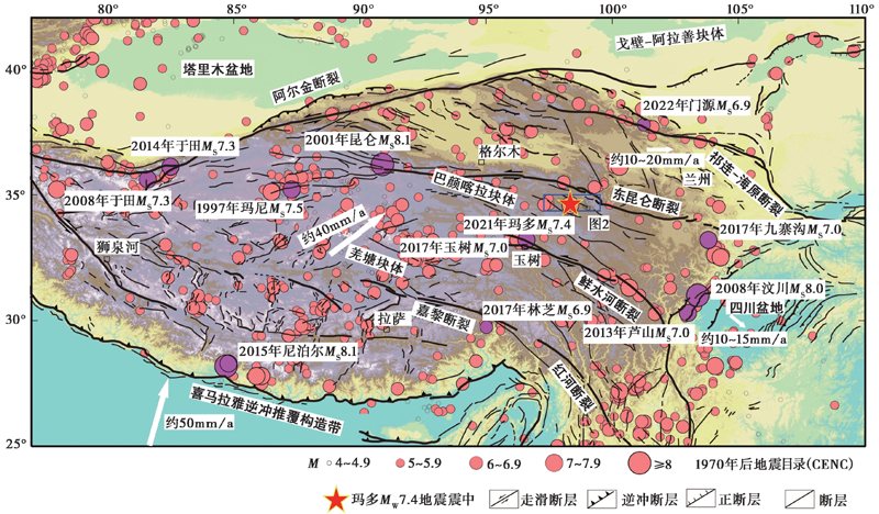
图 1 青藏高原及周边主要的活动断裂和历史地震分布图①(①http:WWW.cenc.ac.cn/。) 浅红色实心圆表示1970年后青藏高原及周边地震的震中, 其中紫色实心圆指示MS>6.9的地震, 红色五星指示2021年5月22日 MW7.4 玛多地震
Fig. 1 Map of major active faults and historical earthquakes in the Tibet Plateau and its surrounding areas.
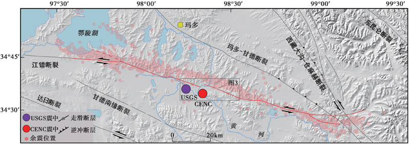
图 2 2021年5月22日玛多 MW7.4 地震破裂及主要区域活动断裂图 红色和紫色实心圆指示玛多地震的震中①②(①http:WWW.cenc.ac.cn/。② https://earthquake.usgs.gov/earthquakes/。), 浅红色实心圆指示地震序列重定位分布图(王未来等, 2021), 红色迹线为InSAR同震形变场的形变迹线, 也是本次航拍作业的中心线
Fig. 2 Map of the May 22, 2021 MW7.4 Madoi earthquake ruptures and major active faults of the region.
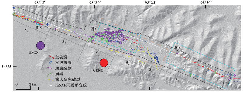
图 3 玛多 MW7.4 地震震中附近的阶区及其周边地表裂缝分布图 依据裂缝的形态特征可分为S1(阶区南支断层主破裂段)、 S2(阶区南支断层次级破裂段)、 S3(黄河漫滩破裂段)、 S4(黄河漫滩东岸破裂段)、 S5(阶区东南侧散乱破裂段)和S6(阶区北支断层主破裂段)6段。红色指示主破裂, 蓝色指示次级破裂, 绿色指示崩塌裂缝, 紫色指示地表裂缝, 黄色指示前人基于野外调查的填图破裂(潘家伟等, 2021), 白色指示InSAR同震形变场的形变迹线, 黑色线框指示DOM的数据区域, 橘红色虚线条指示阶区两侧断层的延长线与阶区的范围
Fig. 3 Surface rupture distribution of the step-overs and their surrounding areas near the epicenter of the MW7.4 Madoi earthquake.
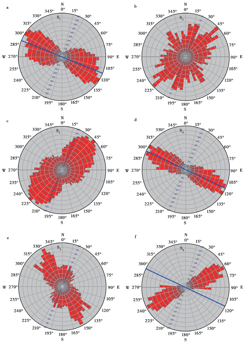
图 4 各段地表破裂走向的玫瑰花图 蓝色线指示主断层的走向
Fig. 4 Rose chart of each segment of surface ruptures.
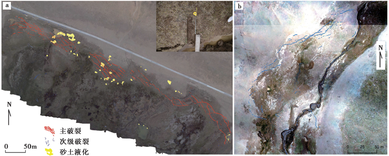
图 5 S1段典型的拉张型地震破裂和S2段的次级破裂
Fig. 5 Typical tensile earthquake rupture of segment S1 and secondary rupture of segment S2.
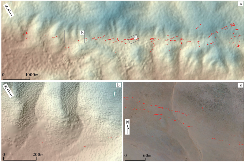
图 6 S6段的线性构造地形、 累积断错冲沟与地表破裂分布图
Fig. 6 Linear structural topography, cumulative displaced gullies and surface rupture of segment S6.
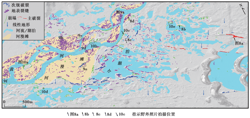
图 7 阶区内各类地震破裂与地裂缝分布图
Fig. 7 Map of earthquake surface rupture and surface fissures in the step-over.

图 8 野外实地拍摄的地表破裂、 地表裂缝照片 a 具有垂向分量的地表破裂; b 沿湖边发育的典型雁列式的地震地表破裂; c 黄河岸边的地表破裂; d 黄河漫滩上的地表裂缝。各照片拍摄于图7所指示的位置
Fig. 8 Photos of surface rupture or surface fissures in the field.
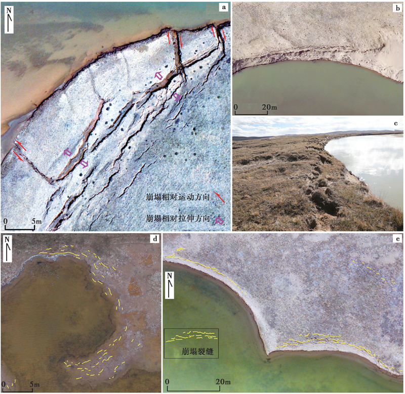
图 9 沿河岸、 湖岸发育的典型崩塌裂缝 a 红色箭头指示崩塌地块的相对运动方向, 紫色箭头指示崩塌地块的相对拉伸方向; b—e 典型的崩塌裂缝展布与河岸、 湖岸线较为一致
Fig. 9 Typical collapse fissures along riverbank or lakeshore.
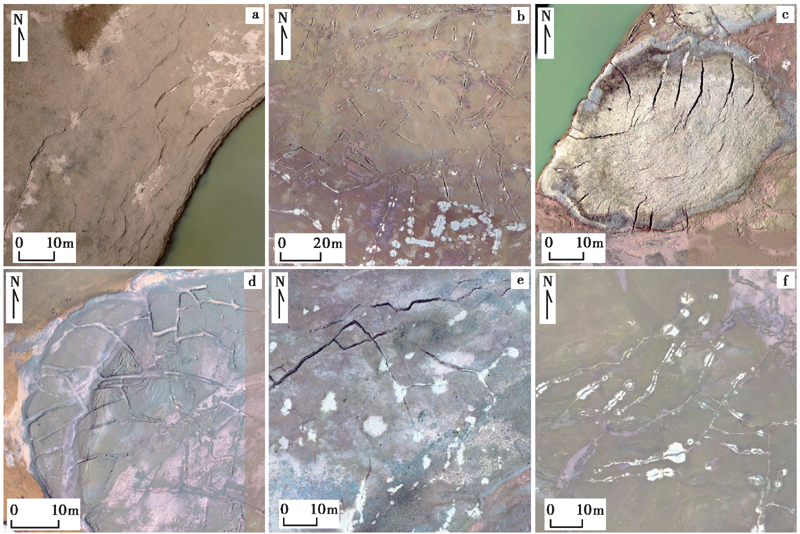
图 10 黄河漫滩上的裂缝 a 沿河岸的地表裂缝; b、 d 网格状地表裂缝; c 爆炸式地表裂缝; e、 f 伴随砂土液化的裂缝
Fig. 10 Surface fissures on the Yellow River floodplain.
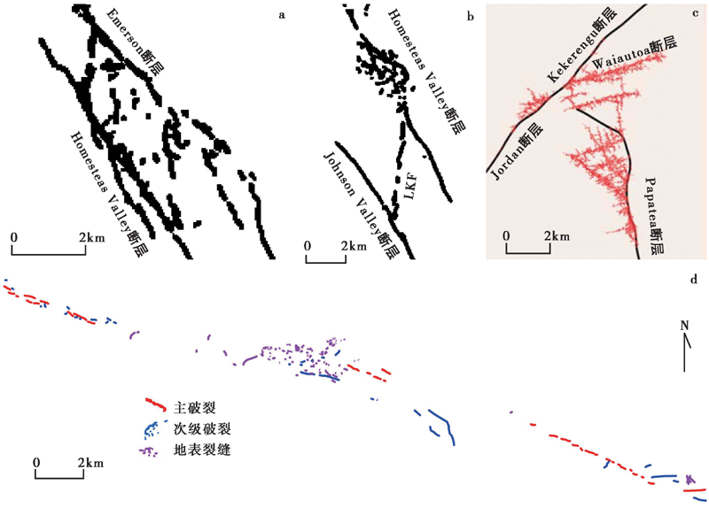
图 11 玛多地震与历史地震复杂几何结构位置的地表破裂图 a 1992年Landers地震Emerson断层与Homestead Valley断层构成的阶区; b Homestead Valley断层与Johnson Valley断层构成的阶区内的分布式地表破裂; c 2016年Kaikōura地震Jordan-Kekerengu-Papatea三联点位置数值模拟的分布式破裂与 损伤(Spotila et al., 1995; Zachariasen et al., 1995; Klinger et al., 2018); d 玛多地震震中区的地震破裂简图
Fig. 11 Map of surface ruptures on the complex geometry of Madoi earthquake and historical earthquake.
| [1] | 邓起东, 张培震, 冉勇康, 等. 2002. 中国活动构造基本特征[J]. 中国科学(D辑), 46(4): 1020-1030, 1057. |
| DENG Qi-dong, ZHANG Pei-zhen, RAN Yong-kang,et al. 2002. Basic characteristics of active tectonics in China[J]. Science in China(Ser D), 46(4): 1020-1030, 1057. (in Chinese) | |
| [2] | 盖海龙, 姚生海, 杨丽萍, 等. 2021. 青海玛多“5·22” MS7.4 地震的同震地表破裂特征、 成因及意义[J]. 地质力学学报, 27(6): 899-912. |
| GAI Hai-long, YAO Sheng-hai, YANG Li-ping,et al. 2021. Characteristics and causes of coseismic surface rupture triggered by the “5·22” MS7.4 Earthquake in Maduo, Qinghai, and their significance[J]. Journal of Geomechanics, 27(6): 899-912. (in Chinese) | |
| [3] | 国家地震局地质研究所, 宁夏回族自治区地震局, 1990. 海原活动断裂带[M]. 北京: 地震出版社. |
| Institute of Geology, China Earthquake Administration, Earthquake Agency of Ningxia Hui Autonomous Region, 1990. Active Haiyuan Fault Zone[M]. Seismological Press, Beijing. (in Chinese) | |
| [4] |
华俊, 赵德政, 单新建, 等. 2021. 2021年青海玛多 MW7.3 地震InSAR的同震形变场、 断层滑动分布及其对周边区域的应力扰动[J]. 地震地质, 43(3): 677-691. doi: 10.3969/j.issn.0253-4967.2021.03.013.
DOI |
| HUA Jun, ZHAO De-zheng, SHAN Xin-jian,et al. 2021. Coseismic deformation field, slip distribution and Coulomb stress disturbance of the 2021 MW7.3 Maduo earthquake using Sentinel-1 InSAR observations[J]. Seismology and Geology, 43(3): 677-691. (in Chinese) | |
| [5] | 李陈侠, 徐锡伟, 闻学泽, 等. 2011. 东昆仑断裂带中东部地震破裂分段性与走滑运动分解作用[J]. 中国科学(D辑), 41(9): 1295-1310. |
| LI Chen-xia, XU Xi-wei, WEN Xue-ze,et al. 2011. Rupture segmentation and slip partitioning of the mid-eastern part of the Kunlun Fault, north Tibetan plateau[J]. Science in China(Ser D), 41(9): 1295-1310. (in Chinese) | |
| [6] | 李春峰, 贺群禄, 赵国光. 2004. 东昆仑活动断裂带东段全新世滑动速率研究[J]. 地震地质, 26(4): 676-687. |
| LI Chun-feng, HE Qun-lu, ZHAO Guo-guang. 2004. Holocene slip rate along the eastern segment of the Kunlun Fault[J]. Seismology and Geology, 26(4): 676-687. (in Chinese) | |
| [7] | 刘静, 陈涛, 张培震, 等. 2013. 机载激光雷达扫描揭示海原断裂带微地貌的精细结构[J]. 科学通报, 58(1): 41-45. |
| LIU Jing, CHEN Tao, ZHANG Pei-zhen, et al. 2013. Illuminating the active Haiyuan Fault, China by airborne light detection and ranging[J]. Chinese Science Bulletin, 58(1): 41-45. (in Chinese) | |
| [8] | 潘家伟, 白明坤, 李超, 等. 2021. 2021年5月22日青海玛多 MW7.4 地震地表破裂带及发震构造[J]. 地质学报, 95(6): 1655-1670. |
| PAN Jia-wei, BAI Ming-kun, LI Chao,et al. 2021. Coseismic surface rupture and seismogenic structure of the 2021-05-22 Maduo(Qinghai) MW7.4 earthquake[J]. Acta Geologica Sinica, 95(6): 1655-1670. (in Chinese) | |
| [9] | 青海省地震局, 中国地震局地壳应力研究所. 1999. 东昆仑活动断裂带[M]. 北京: 地震出版社: 1-227. |
| Seismological Bureau of Qinghai Province, Institute of Crustal Dynamics, China Earthquake Administration. 1999. The Eastern Kunlun Active Fault Zone[M]. Seismological Press, Beijing: 1-227. (in Chinese) | |
| [10] | 王未来, 房立华, 吴建平, 等. 2021. 2021年青海玛多 MS7.4 地震序列精定位研究[J]. 中国科学(D辑), 51(7): 1193-1202. |
| WANG Wei-lai, FANG Li-hua, WU Jian-ping,et al. 2021. Aftershock sequence relocation of the 2021 MS7.4 Maduo earthquake, Qinghai, China[J]. Science in China(Ser D), 51(7): 1193-1202. (in Chinese) | |
| [11] | 魏占玉, Ramon A, 何宏林, 等. 2015. 基于SfM方法的高密度点云数据生成及精度分析[J]. 地震地质, 37(2): 636-648. |
| WEI Zhan-yu, Ramon A, HE Hong-lin,et al. 2015. Accuracy analysis of terrain point cloud acquired by “Structure from Motion” using aerial photos[J]. Seismology and Geology, 37(2): 636-648. (in Chinese) | |
| [12] | 姚文倩, 王子君, 刘静, 等. 2022. 2021年青海玛多 MW7.4 地震同震地表破裂长度的讨论[J]. 地震地质, 44(2): 541-559. |
| YAO Wen-qian, WANG Zi-jun, LIU-ZENG Jing,et al. 2022. Discussion on coseismic surface rupture length of the 2021 MW7.4 Madoi earthquake, Qinghai, China[J]. Seismology and Geology, 44(2): 541-559. (in Chinese) | |
| [13] | 张裕明, 李闵峰, 孟勇琦, 等. 1996. 巴颜喀拉山地区断层活动性研究及其地震地质意义 [G]//邓起东(主编). 活动断裂研究理论与应用. 北京: 地震出版社: 236-244. |
| ZHANG Yu-ming, LI Min-feng, MENG Yong-qi, et al. 1996. Research on fault activities and their seismogeological implication in Bayankala mountain area [G]//DENG Qi-dong(ed). Research on Active Fault. Seismological Press, Beijing: 154-171. (in Chinese) | |
| [14] |
Ajayi O G, Salubi A A, Angbas A F,et al. 2017. Generation of accurate digital elevation models from UAV acquired low percentage overlapping images[J]. International Journal of Remote Sensing, 38(8-10): 3113-3134.
DOI URL |
| [15] |
Angster S, Wesnousky S, Huang W L,et al. 2016. Application of UAV photography to refining the slip rate on the Pyramid Lake fault zone, Nevada[J]. Bulletin of the Seismological Society of America, 106(2): 785-798.
DOI URL |
| [16] |
Bi H, Zheng W, Ge W,et al. 2018. Constraining the distribution of vertical slip on the South Heli Shan Fault(Northeastern Tibet)from high-resolution topographic data[J]. Journal of Geophysical Research: Solid Earth, 123(3): 1925-1953.
DOI URL |
| [17] | Brown M, Lowe D G. 2005. Unsupervised 3D object recognition and reconstruction in unordered datasets[C]. Fifth International Conference on 3-D Digital Imaging Model, (5): 56-63. |
| [18] |
Campillo M, Archuleta R J. 1993. A rupture model for the 28 June 1992 Landers, California, earthquake[J]. Geophysical Research Letters, 20(8): 647-650.
DOI URL |
| [19] |
Choi J-H, Klinger Y, Ferry M,et al. 2018. Geologic inheritance and earthquake rupture processes: The 1905 M≥8 Tsetserleg-Bulnay strike-slip earthquake sequence, Mongolia[J]. Journal of Geophysical Research: Solid Earth, 123(2): 1925-1953.
DOI URL |
| [20] | Deng Q, Chen S, Song F, et al.al. 1986. Variations in the Geometry and Amount of Slip on the Haiyuan(Nanxihaushan)Fault Zone, China and the Surface Rupture of the 1920 Haiyuan Earthquake[M]. Earthquake Source Mechanics, Washington D C: 169-182. |
| [21] | Deng Q, Zhang P, Xu X,et al. 1996. Paleoseismology of the northern piedmont of Tianshan Mountains, northwestern China[J]. Journal of Geophysical Research: Solid Earth, 101(B3): 5895-5920. |
| [22] |
Di Toro G, Nielsen S, Pennacchioni G. 2005. Earthquake rupture dynamics frozen in exhumed ancient faults[J]. Nature, 436(7053): 1009-1102.
DOI URL |
| [23] |
Eberhart-Phillips D, Haeussler P J, Freymueller J T,et al. 2003. The 2002 Denali Fault earthquake, Alaska: A large magnitude, slip-partitioned event[J]. Science, 300(5622): 1113-1118.
PMID |
| [24] |
Elliott A J, Dolan J F, Oglesby D D. 2009. Evidence from coseismic slip gradients for dynamic control on rupture propagation and arrest through stepovers[J]. Journal of Geophysical Research: Solid Earth, 114(B2): 1-8. doi: 10.1029/2008JB005969.
DOI |
| [25] |
Elliott A J, Oskin M E, Liu-Zeng J,et al. 2015. Rupture termination at restraining bends: The last great earthquake on the Altyn Tagh Fault[J]. Geophysical Research Letters, 42(7): 2164-2170.
DOI URL |
| [26] | Fliss S, Bhat H S, Dmowska R,et al. 2005. Fault branching and rupture directivity[J]. Journal of Geophysical Research: Solid Earth, 110(B6): 1-8. |
| [27] | Frankel K L, Dolan J F, Finkel R C,et al. 2007. Spatial variations in slip rate along the Death Valley-Fish Lake Valley fault system determined from LiDAR topographic data and cosmogenic 10Be geochronology[J]. Geophysical Research Letters, 34(18): 1-6. |
| [28] | Hamling I J, Hreinsdottir S, Clark K,et al. 2017. Complex multifault rupture during the 2016 MW7.8 Kaikoura earthquake, New Zealand[J]. Science, 356(6334): 1-10. |
| [29] |
Hudnut K W, Brooks B A, Scharer K,et al. 2020. Airborne Lidar and electro-optical imagery along surface ruptures of the 2019 Ridgecrest earthquake sequence, southern California[J]. Seismological Research Letters, 91(4): 2096-2107.
DOI URL |
| [30] | Kame N, Rice J R, Dmowska R. 2003. Effects of prestress state and rupture velocity on dynamic fault branching[J]. Journal of Geophysical Research: Solid Earth, 108(B5): 1-21. |
| [31] |
Kearse J, Little T A, Van Dissen R J,et al. 2018. Onshore to offshore ground-surface and seabed rupture of the Jordan-Kekerengu-Needles Fault network during the 2016 MW7.8 Kaikōura earthquake, New Zealand[J]. Bulletin of the Seismological Society of America, 108(3B): 1573-1595.
DOI URL |
| [32] | Kirby E, Harkins N, Wang E,et al. 2007. Slip rate gradients along the eastern Kunlun Fault[J]. Tectonics, 26(2): 1-16. |
| [33] |
Klinger Y, Etchebes M, Tapponnier P,et al. 2011. Characteristic slip for five great earthquakes along the Fuyun Fault in China[J]. Nature Geoscience, 4(6): 389-392.
DOI URL |
| [34] |
Klinger Y, Xu X W, Tapponnier P,et al. 2005. High-resolution satellite imagery mapping of the surface rupture and slip distribution of the MW7.8, 14 November 2001 Kokoxili earthquake, Kunlun Fault, northern Tibet, China[J]. Bulletin of the Seismological Society of America, 95(5): 1970-1987.
DOI URL |
| [35] |
Klinger Y, Okubo K, Vallage A,et al. 2018. Earthquake damage patterns resolve complex rupture processes[J]. Geophysical Research Letters, 45(19): 10279-10287. doi: 10.1029/2018GL078842.
DOI URL |
| [36] |
Li H, Pan J, Lin A,et al. 2016. Coseismic surface ruptures associated with the 2014 MW6.9 Yutian earthquake on the Altyn Tagh Fault, Tibetan plateau[J]. Bulletin of the Seismological Society of America, 106(2): 595-608.
DOI URL |
| [37] |
Liu-Zeng J, Zhang Z, Wen L,et al. 2009. Co-seismic ruptures of the 12 May 2008, MS8.0 Wenchuan earthquake, Sichuan: East-west crustal shortening on oblique, parallel thrusts along the eastern edge of Tibet[J]. Earth and Planetary Science Letters, 286(3): 355-370.
DOI URL |
| [38] |
Manighetti I, Perrin C, Dominguez S,et al. 2015. Recovering paleoearthquake slip record in a highly dynamic alluvial and tectonic region(Hope Fault, New Zealand)from airborne lidar[J]. Journal of Geophysical Research: Solid Earth, 120(6): 4484-4509.
DOI URL |
| [39] |
Mitchell T M, Faulkner D R. 2009. The nature and origin of off-fault damage surrounding strike-slip fault zones with a wide range of displacements: A field study from the Atacama fault system, northern Chile[J]. Journal of Structural Geology, 31(8): 802-816.
DOI URL |
| [40] |
Molnar P, Tapponnier P. 1975. Cenozoic tectonics of Asia: Effects of a continental collision: Features of recent continental tectonics in Asia can be interpreted as results of the India-Eurasia collision[J]. Science, 189(4201): 419-426.
PMID |
| [41] |
Oskin M E, Arrowsmith J R, Corona A H,et al. 2012. Near-field deformation from the El Mayor-Cucapah earthquake revealed by differential LiDAR[J]. Science, 335(6069): 702-705.
DOI URL |
| [42] |
Pierce I, Williams A, Koehler R D,et al. 2020. High-resolution structure-from-motion models and orthophotos of the southern sections of the 2019 MW7.1 and 6.4 Ridgecrest earthquakes surface ruptures[J]. Seismological Research Letters, 91(4): 2124-2126.
DOI URL |
| [43] |
Ren J J, Xu X, Yeats R S,et al. 2013. Millennial slip rates of the Tazang Fault, the eastern termination of Kunlun Fault: Implications for strain partitioning in eastern Tibet[J]. Tectonophysics, 608(26): 1180-1200.
DOI URL |
| [44] |
Ren Z K, Zhang Z Q. 2019. Structural analysis of the 1997 MW7.5 Manyi earthquake and the kinematics of the Manyi Fault, central Tibetan plateau[J]. Journal of Asian Earth Sciences, 179: 149-164.
DOI URL |
| [45] | Ren Z K, Zhang Z, Chen T,et al. 2016. Clustering of offsets on the Haiyuan Fault and their relationship to paleoearthquakes[J]. GSA Bulletin, 128(1-2): 3-18. |
| [46] |
Rockwell T K, Klinger Y. 2013. Surface rupture and slip distribution of the 1940 Imperial Valley earthquake, Imperial Fault, southern California: Implications for rupture segmentation and dynamics[J]. Bulletin of the Seismological Society of America, 103(2A): 629-640.
DOI URL |
| [47] | Schwartz D P, Coppersmith K J. 1984. Fault behavior and characteristic earthquakes: Examples from the Wasatch and San Andreas fault zones[J]. Journal of Geophysical Research: Solid Earth, 89(B7): 5681-5698. |
| [48] |
Sieh K, Jones L, Hauksson E,et al. 1993. Near-field investigations of the Landers earthquake sequence, April to July 1992 [J]. Science, 260(5105): 171-176.
PMID |
| [49] |
Spotila J A, Sieh K. 1995. Geologic investigations of a “slip gap” in the surficial ruptures of the 1992 Landers earthquake, southern California[J]. Geophysical Research Letters, 100(B1): 543-559. doi: 10.1029/94JB02471.
DOI |
| [50] |
Tapponnier P, Xu Z, Roger F,et al. 2001. Oblique stepwise rise and growth of the Tibet Plateau[J]. Science, 294(5547): 1671-1677.
PMID |
| [51] |
Turner D, Lucieer A, Wallace L. 2014. Direct georeferencing of ultrahigh-resolution UAV imagery[J]. IEEE Transactions on Geoscience and Remote Sensing, 52(5): 2738-2745.
DOI URL |
| [52] | Vallage A, Klinger Y, Grandin R,et al. 2015. Inelastic surface deformation during the 2013 MW7.7 Balochistan, Pakistan, earthquake[J]. Geology, 43(12): 1079-1082. |
| [53] |
Vallage A, Klinger Y, Lacassin R,et al. 2016. Geological structures control on earthquake ruptures: The MW7.7, 2013, Balochistan earthquake, Pakistan[J]. Geophysical Research Letters, 43(19): 10155-10163.
DOI URL |
| [54] |
van der Woerd J, Tapponnier P, Ryerson F J,et al. 2002. Uniform postglacial slip-rate along the central 600km of the Kunlun Fault(Tibet), from 26Al, 10Be, and 14C dating of riser offsets, and climatic origin of the regional morphology[J]. Geophysical Journal International, 148(3): 356-388.
DOI URL |
| [55] |
Wesnousky S G. 1988. Seismological and structural evolution of strike-slip faults[J]. Nature, 335(6188): 340-343.
DOI URL |
| [56] |
Wesnousky S G. 1994. The Gutenberg-Richter or characteristic earthquake distribution, which is it?[J]. Bulletin of the Seismological Society of America, 84(6): 1940-1959.
DOI URL |
| [57] |
Wesnousky S G. 2006. Predicting the endpoints of earthquake ruptures[J]. Nature, 444(7117): 358-360.
DOI URL |
| [58] |
Wesnousky S G. 2008. Displacement and geometrical characteristics of earthquake surface ruptures: Issues and implications for seismic-hazard analysis and the process of earthquake rupture[J]. Bulletin of the Seismological Society of America, 98(4): 1609-1632. doi: org/10.1785/0120070111.
DOI URL |
| [59] |
Westoby M J, Brasington J, Glasser N F,et al. 2012. ‘Structure from Motion’ photogrammetry: A low cost, effective tool for geoscience applications[J]. Geomorphology, 179: 300-314.
DOI URL |
| [60] |
Xu X, Chen W, Ma W,et al. 2002. Surface rupture of the Kunlunshan earthquake( MS8.1 ), northern Tibetan plateau, China[J]. Seismological Research Letters, 73(6): 884-892.
DOI URL |
| [61] | Zachariasen J, Sieh K. 1995. The transfer of slip between two en echelon strike-slip faults: A case study from the 1992 Landers earthquake, southern California[J]. Journal of Geophysical Research: Solid Earth, 100(B8): 15281-15301. |
| [62] |
Zhang P, Mao F, Slemmons D B. 1999. Rupture terminations and size of segment boundaries from historical earthquake ruptures in the Basin and Range Province[J]. Tectonophysics, 308(1): 37-52.
DOI URL |
| [63] |
Zielke O, Arrowsmith J R, Grant Ludwig L,et al. 2012. High-resolution topography-derived offsets along the 1857 Fort Tejon earthquake rupture trace, San Andreas Fault[J]. Bulletin of the Seismological Society of America, 102(3): 1135-1154.
DOI URL |
| [64] |
Zielke O, Arrowsmith J R, Ludwig L G,et al. 2010. Slip in the 1857 and earlier large earthquakes along the Carrizo Plain, San Andreas Fault[J]. Science, 327(5969): 1119-1122.
DOI PMID |
| [1] | 李路瑶, 丁锐, 姜大伟, 张世民. 阿尔金断裂东段的河流阶地累积位错[J]. 地震地质, 2024, 46(3): 547-569. |
| [2] | 邓文泽, 刘杰, 杨志高, 孙丽, 张雪梅. 青海玛多MS7.4地震震源破裂过程反演结果的初步分析[J]. 地震地质, 2022, 44(4): 1059-1070. |
| [3] | 魏延坤, 陈晓利. 不同地震滑坡危险性评价方法的适用性探讨——以玛多MS7.4地震为例[J]. 地震地质, 2022, 44(3): 590-603. |
| [4] | 姚文倩, 王子君, 刘静, 刘小利, 韩龙飞, 邵延秀, 王文鑫, 徐晶, 秦可心, 高云鹏, 王焱, 李金阳, 曾宪阳. 2021年青海玛多MW7.4地震同震地表破裂长度的讨论[J]. 地震地质, 2022, 44(2): 541-559. |
| [5] | 邵延秀, 刘静, 高云鹏, 王文鑫, 姚文倩, 韩龙飞, 刘志军, 邹小波, 王焱, 李云帅, 刘璐. 同震地表破裂的位移测量与弥散变形分析——以2021年青海玛多MW7.4地震为例[J]. 地震地质, 2022, 44(2): 506-523. |
| [6] | 刘小利, 夏涛, 刘静, 姚文倩, 徐晶, 邓德贝尔, 韩龙飞, 贾治革, 邵延秀, 王焱, 乐子扬, 高天琪. 2021年青海玛多MW7.4地震分布式同震地表裂缝特征[J]. 地震地质, 2022, 44(2): 461-483. |
| [7] | 梁子晗, 魏占玉, 庄其天, 孙稳, 何宏林. 基于高分辨率地形数据的富蕴M8.0地震地表破裂带精细特征[J]. 地震地质, 2021, 43(6): 1507-1523. |
| [8] | 谈洪波, 王嘉沛, 杨光亮, 陈正松, 吴桂桔, 申重阳, 黄金水. 2021年玛多MS7.4地震的震后效应模拟[J]. 地震地质, 2021, 43(4): 936-957. |
| [9] | 李智敏, 李文巧, 李涛, 徐岳仁, 苏鹏, 郭鹏, 孙浩越, 哈广浩, 陈桂华, 袁兆德, 李忠武, 李鑫, 杨理臣, 马震, 姚生海, 熊仁伟, 张彦博, 盖海龙, 殷翔, 徐玮阳, 董金元. 2021年5月22日青海玛多MS7.4地震的发震构造和地表破裂初步调查[J]. 地震地质, 2021, 43(3): 722-737. |
| [10] | 华俊, 赵德政, 单新建, 屈春燕, 张迎峰, 龚文瑜, 王振杰, 李成龙, 李彦川, 赵磊, 陈晗, 范晓冉, 王绍俊. 2021年青海玛多MW7.3地震InSAR的同震形变场、断层滑动分布及其对周边区域的应力扰动[J]. 地震地质, 2021, 43(3): 677-691. |
| 阅读次数 | ||||||
|
全文 |
|
|||||
|
摘要 |
|
|||||
