地震地质 ›› 2025, Vol. 47 ›› Issue (2): 577-596.DOI: 10.3969/j.issn.0253-4967.2025.02.20250047
崔华伟1,2,3,4,5)( ), 尹昕忠1,4,6),*(), 陈九辉1,4,6), 郭飚1,4,6), 李涛1,4,6), 姚远1,4,6,7), 李世莹2,3,5), 贾震2,3,5)
收稿日期:2025-02-08
修回日期:2025-03-11
出版日期:2025-04-20
发布日期:2025-06-07
通讯作者:
* 尹昕忠, 男, 1983年生, 副研究员, 主要从事宽频带地震学研究, E-mail: yinxinzhong@ies.ac.cn。
作者简介:崔华伟, 男, 1990年生, 现为中国地震局地质研究所固体地球物理学专业在读博士研究生, 主要从事双差定位、 震源机制和应力场等方面研究, E-mail: cuihuawei19900920@163.com。
基金资助:
CUI Hua-wei1,2,3,4,5)(), YIN Xin-zhong1,4,6),*(), CHEN Jiu-hui1,4,6), GUO Biao1,4,6), LI Tao1,4,6), YAO Yuan1,4,6,7), LI Shi-ying2,3,5), JIA Zhen2,3,5)
Received:2025-02-08
Revised:2025-03-11
Online:2025-04-20
Published:2025-06-07
摘要:
帕米尔高原东北部地区构造变形复杂、 地震活动强烈, 分析其地震分布特点和构造应力场特征, 有助于探讨该区域复杂多变的构造变形特征及其孕震环境。文中基于中国地震台网中心地震观测报告和从多方面搜集得到的震源机制数据, 运用HYPODD方法和SATSI方法分别进行了地震重定位和构造应力场反演, 获得了研究区内整体地震活动和构造应力场分布特征: 1)研究区内震源深度分布与地壳厚度呈正相关。2)齐姆根弧形构造带、 费尔干纳和皮羌断裂两侧的震源深度存在明显差异, 表明这些构造可能为重要构造分界线。3)1902年阿图什 MW7.7 地震周边地壳应力释放充分, 导致天山山脉和塔西南坳陷交界地区小地震分布稀疏。4)受印度板块自南向北的推挤作用影响, 帕米尔高原、 天山山脉和塔里木盆地均呈现近SN向的低倾角挤压应力场。5)研究区内的构造应力场呈现出明显的构造差异性, 主要体现在: 帕米尔高原为走滑应力机制, 显示其呈EW向扩张, 而天山山脉呈逆冲应力机制并不断隆升。帕米尔高原及其与天山山脉碰撞带两侧最优主张应力轴倾伏角和R值差异较大。6)塔西南坳陷和巴楚隆起区的走滑和逆冲应力机制不同, 且二者密度和速度差异较大, 揭示出塔里木盆地内部结构复杂的特点。
崔华伟, 尹昕忠, 陈九辉, 郭飚, 李涛, 姚远, 李世莹, 贾震. 帕米尔高原东北部地震活动及构造应力场特征[J]. 地震地质, 2025, 47(2): 577-596.
CUI Hua-wei, YIN Xin-zhong, CHEN Jiu-hui, GUO Biao, LI Tao, YAO Yuan, LI Shi-ying, JIA Zhen. CHARACTERISTICS OF SEISMICITY AND TECTONIC STRESS FIELD IN THE NORTHEASTERN REGION OF THE PAMIR PLATEAU[J]. SEISMOLOGY AND GEOLOGY, 2025, 47(2): 577-596.
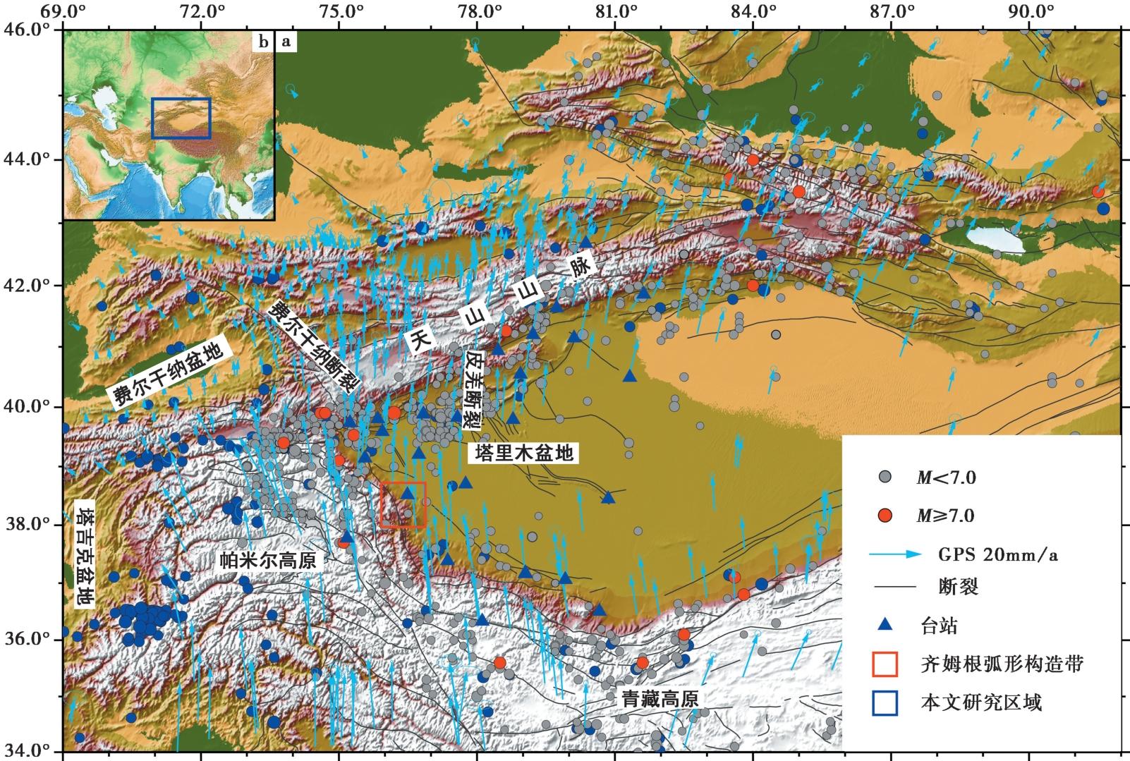
图 1 帕米尔高原东北部地区构造背景 红色和灰色圆点分别表示M≥7和M<7的地震; 蓝色箭头表示来源于文献(Wang et al., 2020)的GPS数据; 黑色实线表示断裂; 蓝色三角形表示双差重定位使用的台站
Fig. 1 The tectonic background in the northeastern region of the Pamir Plateau.
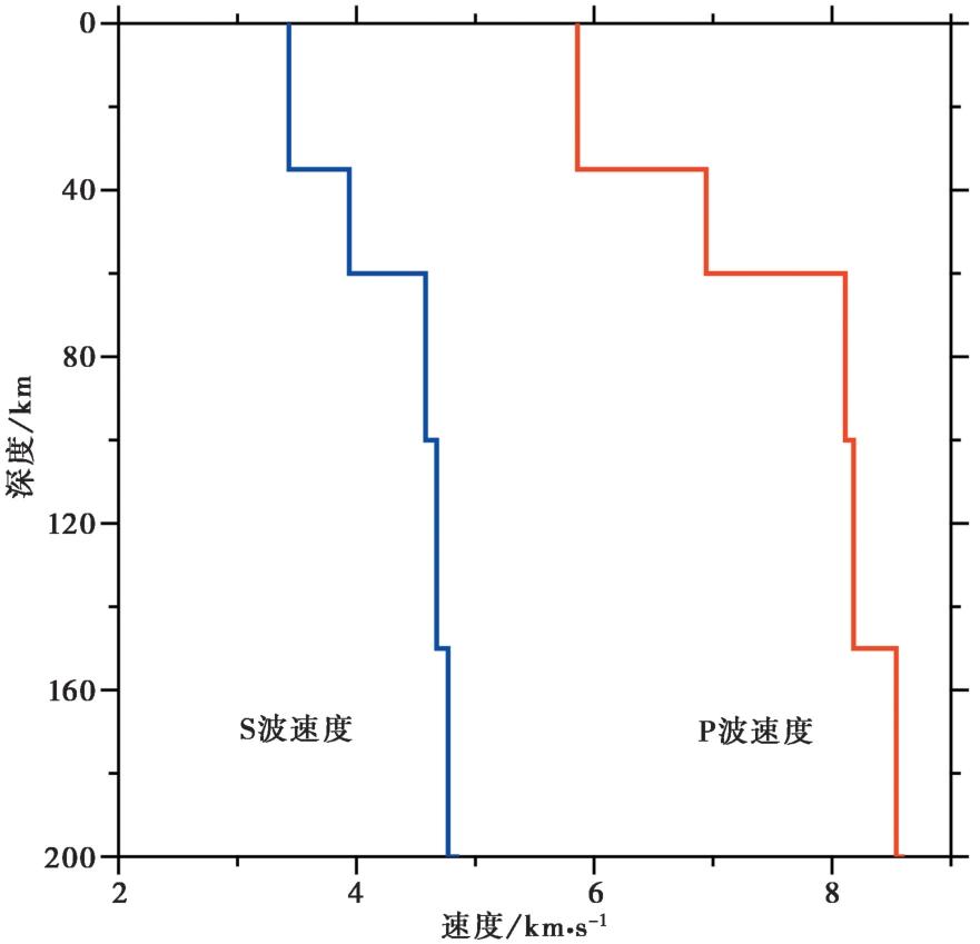
图 2 地震重定位使用的速度模型 红色和蓝色实线分别表示双差重定位使用的P和S波一维速度
Fig. 2 The velocity model used in earthquake relocation.
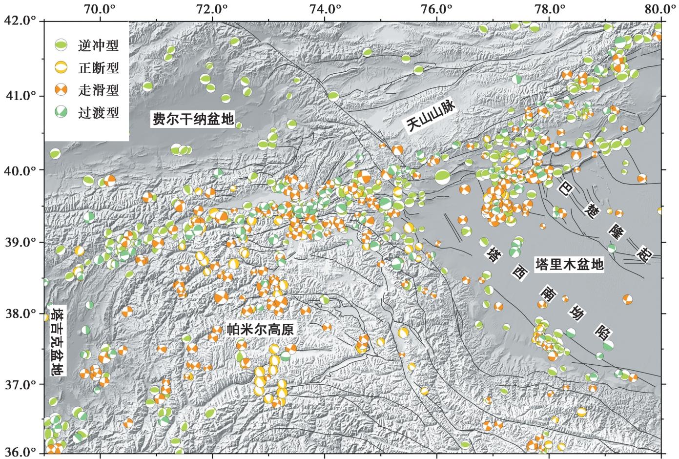
图 3 帕米尔高原及其周缘地震的震源机制 不同颜色表示不同类型的震源机制, 震源机制类型按照Zoback(1992)准则分类
Fig. 3 The focal mechanisms in the Pamir Plateau and its adjacent area.
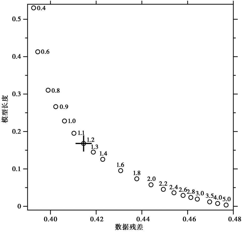
图 4 构造应力场反演的折中曲线和最优阻尼因子
Fig. 4 Trade-off curve and the best damping factor by tectonic stress field inversion.

图 5 重定位后地震分布 不同颜色的圆圈表示不同深度的地震; 蓝色实线表示剖面位置; 黑色实线表示断裂; 绿色沙滩球和浅蓝色实线表示1902年阿图什(喀什葛尔)MW7.7地震的震源机制和最大烈度等值线(Kulikova et al., 2017; Chen et al., 2022); 紫色虚线为地震稀疏区
Fig. 5 The distribution of the relocated earthquakes.
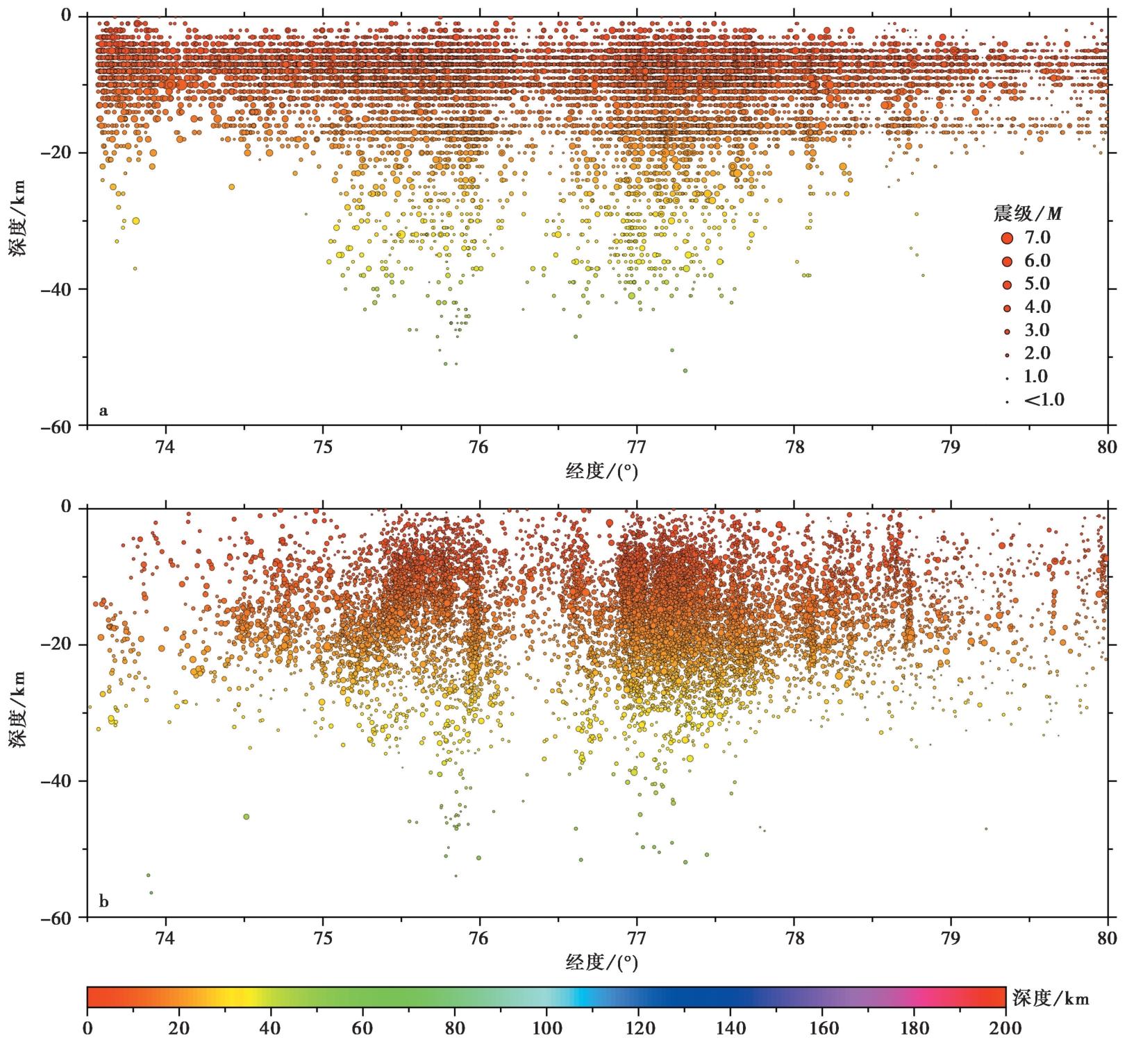
图 6 重定位前、 后震源深度沿经度分布图 a、 b 重定位前、 后震源深度沿经度的投影
Fig. 6 The distribution of the source depth before and after relocation along the longitude.
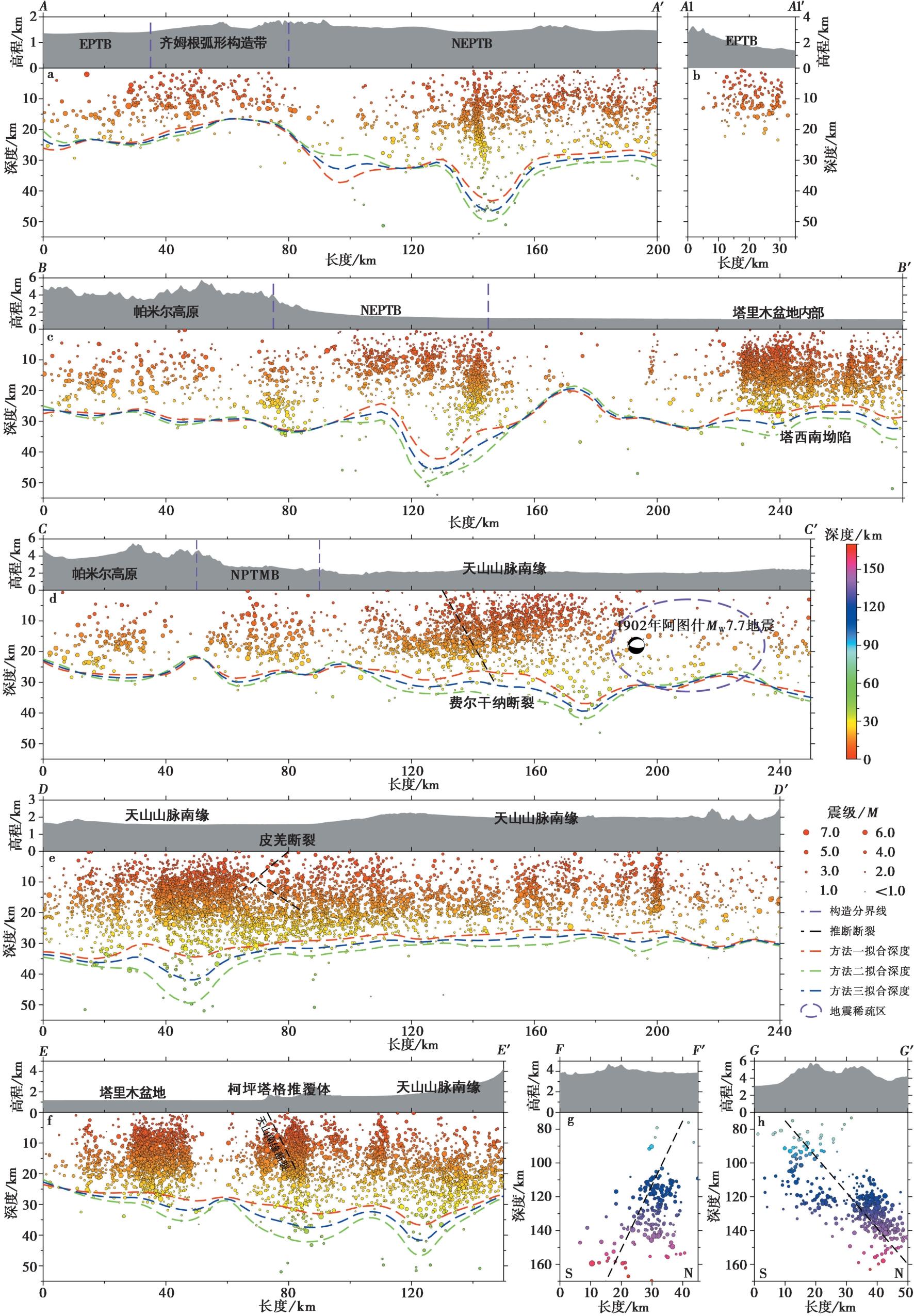
图 7 帕米尔高原东北部地震剖面图 不同颜色的圆圈表示不同深度的地震; 红色、 绿色和蓝色实线分别表示拟合的震源深度趋势; 紫色实线表示构造分界线; 黑色虚线表示推断断裂。EPTB 帕米尔东缘与塔里木盆地接壤带; NEPTB 帕米尔东北缘与塔里木盆地接壤带; NPTMB 帕米尔北缘与天山山脉接壤带
Fig. 7 The profiles of the earthquakes in the northeastern region of the Pamir Plateau.
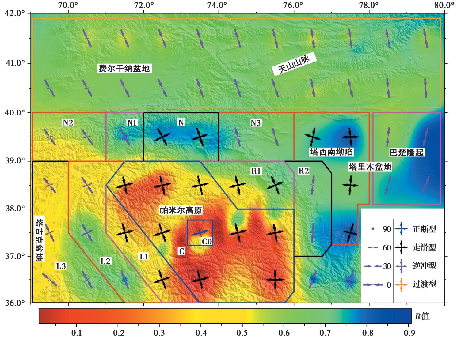
图 8 帕米尔高原及其周缘构造应力场 不同颜色的轴表示不同类型的应力机制类型; 箭头方向表示应力轴方位; 轴的长度表示应力轴的倾伏角
Fig. 8 The tectonic stress field in the Pamir Plateau and its adjacent area.
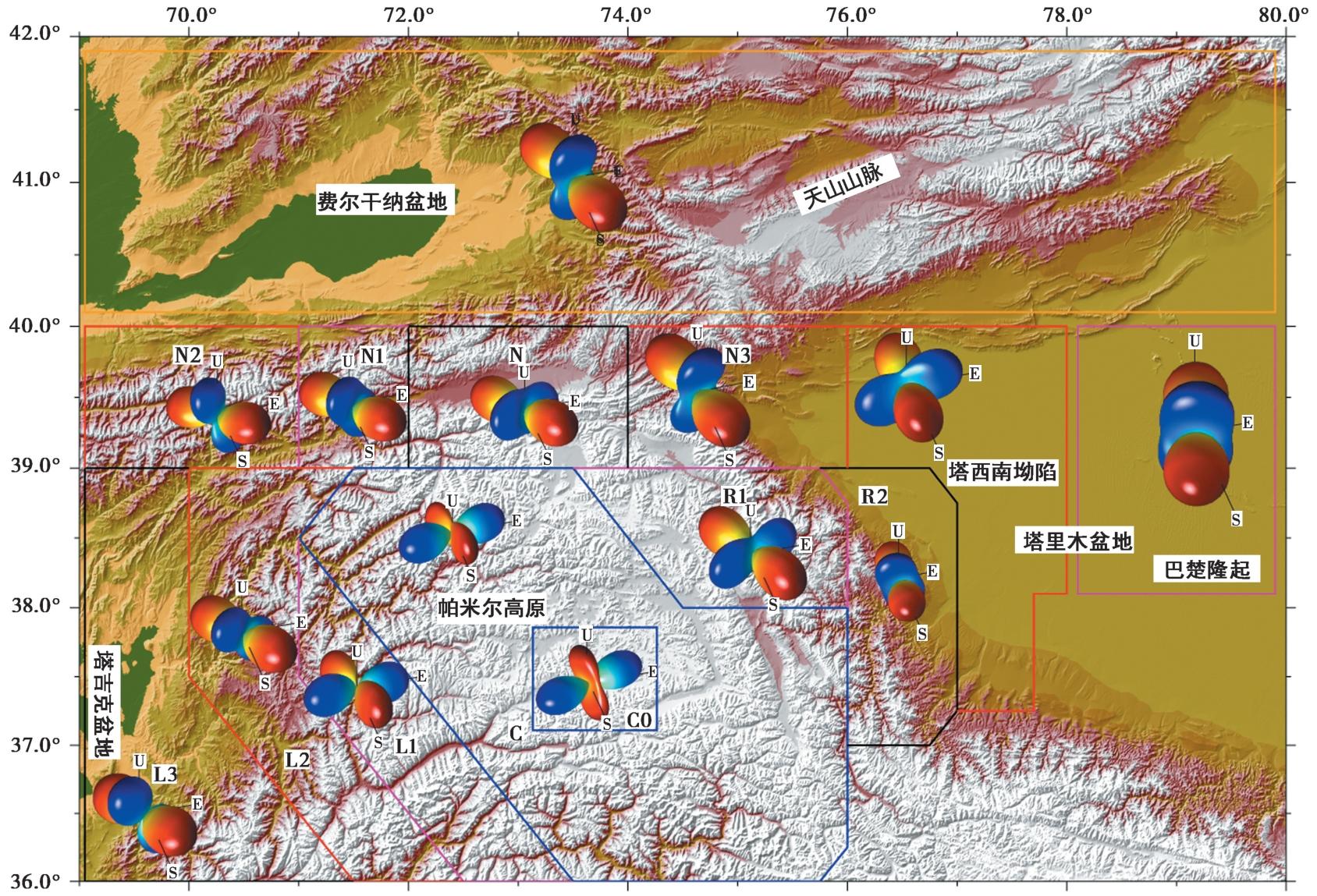
图 9 帕米尔高原及其周缘构造应力辐射花样 应力辐射花样的红色和蓝色部分分别表示压缩区和拉张区
Fig. 9 The tectonic stress radiation pattern in the Pamir Plateau and its adjacent area.
| [1] |
陈杰, 李涛, 孙建宝, 等. 2016. 2016年11月25日新疆阿克陶 MW6.6 地震发震构造与地表破裂[J]. 地震地质, 38(4): 1160-1174. doi: 10.3969/j.issn.0253-4967.2016.04.028.
|
|
DOI |
|
| [2] |
崔华伟, 万永革, 黄骥超, 等. 2019. 帕米尔—兴都库什地区构造应力场反演及拆离板片应力形因子特征研究[J]. 地球物理学报, 62(5): 1633-1649.
DOI |
|
|
|
| [3] |
代成龙, 张玲, 梁诗明, 等. 2021. 中亚塔拉斯-费尔干纳断裂现今的走滑速率及其分段变化特征: 基于GPS观测的深究[J]. 地震地质, 43(2): 263-279. doi: 10.3969/j.issn.0253-4967.2021.02.001.
|
|
DOI |
|
| [4] |
高国英, 聂晓红, 夏爱国. 2011. 1902年阿图什 8¼级地震前后地震活动特征[J]. 内陆地震, 25(2): 120-128.
|
|
|
|
| [5] |
葛进, 石许华, 陈汉林, 等. 2022. 帕米尔弧形构造带晚第四纪以来的不对称径向逆冲: 多时空尺度变形速率的启示[J]. 第四纪研究, 42(3): 673-691.
|
|
|
|
| [6] |
郭飚, 刘启元, 陈九辉, 等, 2002. 新疆伽师强震区余震序列的地震台阵定位[J]. 地震地质, 24(2): 199-207.
|
|
|
|
| [7] |
李金, 王琼, 吴传勇, 等. 2016. 2015年7月3日皮山6.5级地震发震构造初步研究[J]. 地球物理学报, 59(8): 2859-2870.
DOI |
|
|
|
| [8] |
梁姗姗, 邹立晔, 刘艳琼, 等. 2024. 2024年3—6月中国大陆地区M≥4.0地震震源机制解测定[J]. 地震科学进展, 54(7): 476-482.
|
|
|
|
| [9] |
罗钧, 左可桢, 赵翠萍. 2023. 2021年新疆皮山 MS5.4 和叶城 MS5.4 双震序列及青藏高原西北缘地震活动特征[J]. 地球物理学报, 66(4): 1481-1495.
|
|
|
|
| [10] |
沈军, 陈建波, 王翠, 等. 2006. 2003年2月24日新疆巴楚-伽师6.8级地震发震构造[J]. 地震地质, 28(2): 205-212.
|
|
|
|
| [11] |
盛书中, 胡晓辉, 王晓山, 等. 2022. 云南及邻区地壳应力场研究[J]. 地球物理学报, 65(9): 3252-3267.
|
|
|
|
| [12] |
唐兰兰, 赵翠萍, 王海涛. 2012. 2008年新疆乌恰6.8级地震序列震源特征及帕米尔东北缘应力场研究[J]. 地球物理学报, 55(4): 1228-1239.
|
|
|
|
| [13] |
万永革. 2016. 地震学导论[M]. 北京: 科学出版社:384-458.
|
|
|
|
| [14] |
万永革, 盛书中, 许雅儒, 等. 2011. 不同应力状态和摩擦系数对综合P波辐射花样影响的模拟研究[J]. 地球物理学报, 54(4): 994-1001.
|
|
|
|
| [15] |
谢会文, 陈新伟, 朱民, 等. 2017. 塔里木盆地玛扎塔格断裂带变形特征、 演化及对深层油气成藏的控制[J]. 地球科学, 42(9): 1578-1589.
|
|
|
|
| [16] |
杨庚, 陈竹新. 2023. 塔西南齐姆根楔形构造与走滑构造叠加两阶段演化模式[J]. 地质科学, 58(2): 347-378.
|
|
|
|
| [17] |
杨庚, 石昕, 贾承造, 等. 2008. 塔里木盆地西北缘柯坪巴楚地区皮羌断裂与色力布亚断裂空间关系[J]. 铀矿地质, 24(4): 201-207.
|
|
|
|
| [18] |
杨勇, 汤良杰, 郭颖, 等. 2016. 柯坪冲断带皮羌断裂的新生代构造演化特征[J]. 中国矿业大学学报, 45(6): 1204-1210.
|
|
|
|
| [19] |
尹光华, 蒋靖祥, 穆桂金. 2003. 2003年2月24日巴楚-伽师6.8级地震的构造背景初探[J]. 干旱区地理, 26(2): 103-109.
|
|
|
|
| [20] |
赵瑞斌, 沈军, 李军. 2001. 1902年新疆阿图什 8¼级地震形变特征与发震模式初探[J]. 地震地质, 23(4): 493-500.
|
|
|
|
| [21] |
|
| [22] |
|
| [23] |
|
| [24] |
|
| [25] |
|
| [26] |
|
| [27] |
|
| [28] |
|
| [29] |
|
| [30] |
|
| [31] |
|
| [32] |
|
| [33] |
|
| [34] |
|
| [35] |
|
| [36] |
|
| [37] |
|
| [38] |
|
| [39] |
|
| [40] |
|
| [41] |
|
| [42] |
|
| [43] |
|
| [44] |
|
| [45] |
|
| [46] |
|
| [47] |
|
| [48] |
|
| [49] |
|
| [50] |
|
| [51] |
|
| [52] |
|
| [53] |
|
| [54] |
|
| [55] |
|
| [56] |
|
| [57] |
|
| [58] |
|
| [59] |
|
| [60] |
|
| [61] |
|
| [62] |
DOI |
| [63] |
|
| [64] |
|
| [65] |
|
| [66] |
|
| [67] |
|
| [68] |
|
| [69] |
|
| [1] | 李岩, 陈俊磊, 吕思宇, 王宇栋, 傅磊. 景谷地震序列触发关系及应力场反演[J]. 地震地质, 2026, 48(2): 561-581. |
| [2] | 常金龙, 甘卫军, 周晨, 朱成林, 刘长生, 姚程越. 依兰-伊通断裂北段应变状态及发震机制讨论[J]. 地震地质, 2026, 48(1): 200-216. |
| [3] | 王霞, 宋美卿, 吴昊昱, 梁向军, 吕睿, 郭文峰, 张娜, 李金. 山西裂谷构造应力场特征及其动力学意义[J]. 地震地质, 2026, 48(1): 257-277. |
| [4] | 宫猛, 邹献昆, 王晓山, 李广, 盛书中, 李红星, 徐荣华, 路昌胜. 京西北地区地壳速度结构与地震重新定位联合反演[J]. 地震地质, 2025, 47(4): 1132-1151. |
| [5] | 唐茂云, 李翠平, 黄世源, 董蕾, 高见, 李勇. 泸县—荣昌地区地震活动时空演化与构造应力场特征[J]. 地震地质, 2025, 47(4): 1183-1203. |
| [6] | 董春丽, 郭文峰, 刘瑞春, 丁大业. 山西中南部中小地震震源机制应力特征和地震活动相关性分析[J]. 地震地质, 2025, 47(4): 1222-1243. |
| [7] | 郭钊吾, 鲁人齐, 张金玉, 房立华, 刘冠伸, 吴熙彦, 孙晓, 祁诗淼. 2025年1月7日西藏定日MS6.8强震发震断层三维模型与地震构造环境[J]. 地震地质, 2025, 47(3): 671-688. |
| [8] | 许月怡, 徐贝贝, 徐晨雨, 邵志刚, 胡朝忠. 基于远震P波、 强震波形和InSAR联合反演2025年西藏定日MS6.8地震破裂过程[J]. 地震地质, 2025, 47(3): 734-746. |
| [9] | 王鹏, 戴宗辉, 孔雪, 李铂, 徐长朋, 张梦昕. 西藏定日 MS6.8 地震序列应力场演化特征分析[J]. 地震地质, 2025, 47(3): 881-896. |
| [10] | 李金, 邓明文, 张治广, 孙业君, 姚远, 徐凯驰. 2024年塔里木盆地尉犁5级震群发震构造[J]. 地震地质, 2025, 47(2): 463-487. |
| [11] | 盛书中, 王倩茹, 李振月, 李红星, 张小娟, 葛坤朋, 宫猛. 基于构造应力场研究2025年西藏定日6.8级地震的发震构造[J]. 地震地质, 2025, 47(1): 49-63. |
| [12] | 王鑫, 张珂, 王玥. 内蒙古阿鲁科尔沁旗MS5.9与MS4.7地震序列特征及其发震构造分析[J]. 地震地质, 2024, 46(6): 1314-1331. |
| [13] | 许永强, 雷建设, 胡晓辉. 2021年5月21日云南漾濞MS6.4地震序列双差重定位及其构造意义[J]. 地震地质, 2024, 46(5): 1066-1090. |
| [14] | 许永强, 雷建设. 大同火山群及邻区中小地震重定位[J]. 地震地质, 2024, 46(2): 336-356. |
| [15] | 郭祥云, 房立华, 韩立波, 李振月, 李春来, 苏珊. 川滇菱形块体东边界震源机制与应力场特征[J]. 地震地质, 2024, 46(2): 371-396. |
| 阅读次数 | ||||||
|
全文 |
|
|||||
|
摘要 |
|
|||||
