SEISMOLOGY AND EGOLOGY ›› 2021, Vol. 43 ›› Issue (6): 1412-1434.DOI: 10.3969/j.issn.0253-4967.2021.06.005
• Research paper • Previous Articles Next Articles
GAO Fan( ), HAN Zhu-jun(), YUAN Ren-mao, DONG Shao-peng, GUO Peng
Received:2021-03-15
Revised:2021-05-06
Online:2021-12-20
Published:2022-01-29
Contact:
HAN Zhu-jun
高帆(), 韩竹军(), 袁仁茂, 董绍鹏, 郭鹏
通讯作者:
韩竹军
作者简介:高帆, 女, 1996年生, 2018年于河北地质大学获测绘工程专业学士学位, 现为中国地震局地质研究所构造地质学专业在读硕士研究生, 主要从事活动构造等方面的研究, E-mail: gaofan@ies.ac.cn。
基金资助:CLC Number:
GAO Fan, HAN Zhu-jun, YUAN Ren-mao, DONG Shao-peng, GUO Peng. FEATURES OF ANCIENT LANDSLIDES AND THEIR SEISMIC-GEOLOGICAL SIGNIFICANCE ALONG THE SOUTHERN SEGMENT OF XIAOJIANG FAULT IN THE SOUTHEASTERN YUNNAN, CHINA[J]. SEISMOLOGY AND EGOLOGY, 2021, 43(6): 1412-1434.
高帆, 韩竹军, 袁仁茂, 董绍鹏, 郭鹏. 滇东南地区小江断裂南段历史滑坡特征及其地震地质意义[J]. 地震地质, 2021, 43(6): 1412-1434.
Add to citation manager EndNote|Ris|BibTeX
URL: https://www.dzdz.ac.cn/EN/10.3969/j.issn.0253-4967.2021.06.005

Fig. 1 Fault features and landslide distribution of the southern segment of Xiaojiang Fault.
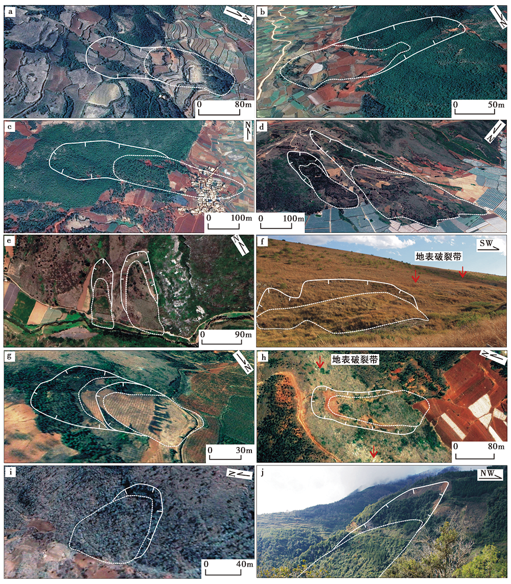
Fig. 2 Interpretation map of the landslide in the southern section of the Xiaojiang Fault.
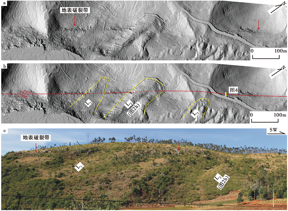
Fig. 3 Map showing the development characteristics of landslides in Shenxiandong area.
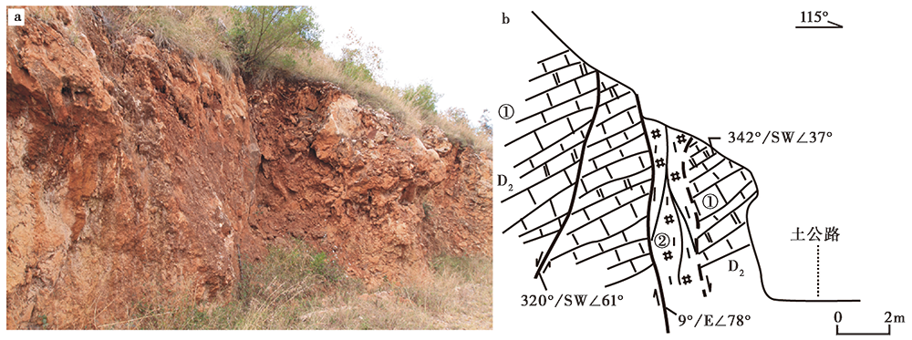
Fig. 4 Profile of the fault on the northern hillside of Shenxiandong Reservoir.
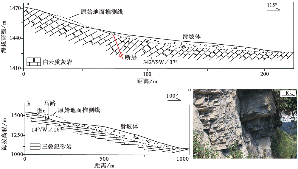
Fig. 5 Two typical landslide profiles.
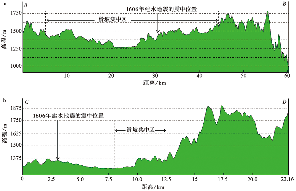
Fig. 6 Topographic profile along the southern section of the Xiaojiang Fault.
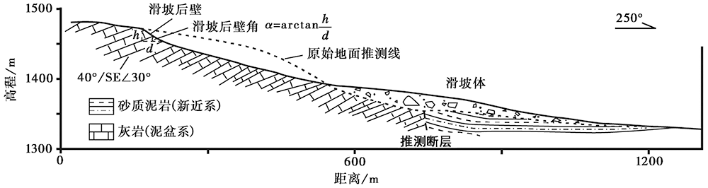
Fig. 7 Profile of Mawangzhuang landslide and the measuring method for the main scarps.
| 滑坡名称 | h/m | d/m | 滑坡后壁角 |
|---|---|---|---|
| 白云村北滑坡 | 28.6 | 47.9 | 31.0° |
| 白云村西滑坡 | 49.6 | 98.5 | 26.7° |
| 莫新滑坡 | 70.5 | 125.2 | 29.4° |
| 马王庄滑坡1 | 54.8 | 101.2 | 28.4° |
| 马王庄滑坡2 | 18.7 | 32.2 | 30.1° |
| 泸江滑坡1 | 14.4 | 24.3 | 30.7° |
| 泸江滑坡2 | 12.3 | 20.9 | 30.4° |
| 垃圾场滑坡 | 3.3 | 5.4 | 31.4° |
| 放马坪滑坡 | 14.6 | 27.3 | 28.1° |
| 神仙洞滑坡 | 13.6 | 24.1 | 29.4° |
| 两岔河滑坡 | 16.0 | 30.5 | 27.7° |
| 四家滑坡 | 61.0 | 92.3 | 33.5° |
Table1 Slope angles of landslide main scarps
| 滑坡名称 | h/m | d/m | 滑坡后壁角 |
|---|---|---|---|
| 白云村北滑坡 | 28.6 | 47.9 | 31.0° |
| 白云村西滑坡 | 49.6 | 98.5 | 26.7° |
| 莫新滑坡 | 70.5 | 125.2 | 29.4° |
| 马王庄滑坡1 | 54.8 | 101.2 | 28.4° |
| 马王庄滑坡2 | 18.7 | 32.2 | 30.1° |
| 泸江滑坡1 | 14.4 | 24.3 | 30.7° |
| 泸江滑坡2 | 12.3 | 20.9 | 30.4° |
| 垃圾场滑坡 | 3.3 | 5.4 | 31.4° |
| 放马坪滑坡 | 14.6 | 27.3 | 28.1° |
| 神仙洞滑坡 | 13.6 | 24.1 | 29.4° |
| 两岔河滑坡 | 16.0 | 30.5 | 27.7° |
| 四家滑坡 | 61.0 | 92.3 | 33.5° |
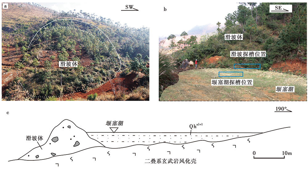
Fig. 8 The morphological features of the front(a)and side(b)of the Liangchahe landslide, the layout of the trenches, and the profile of the dammed lake(c).
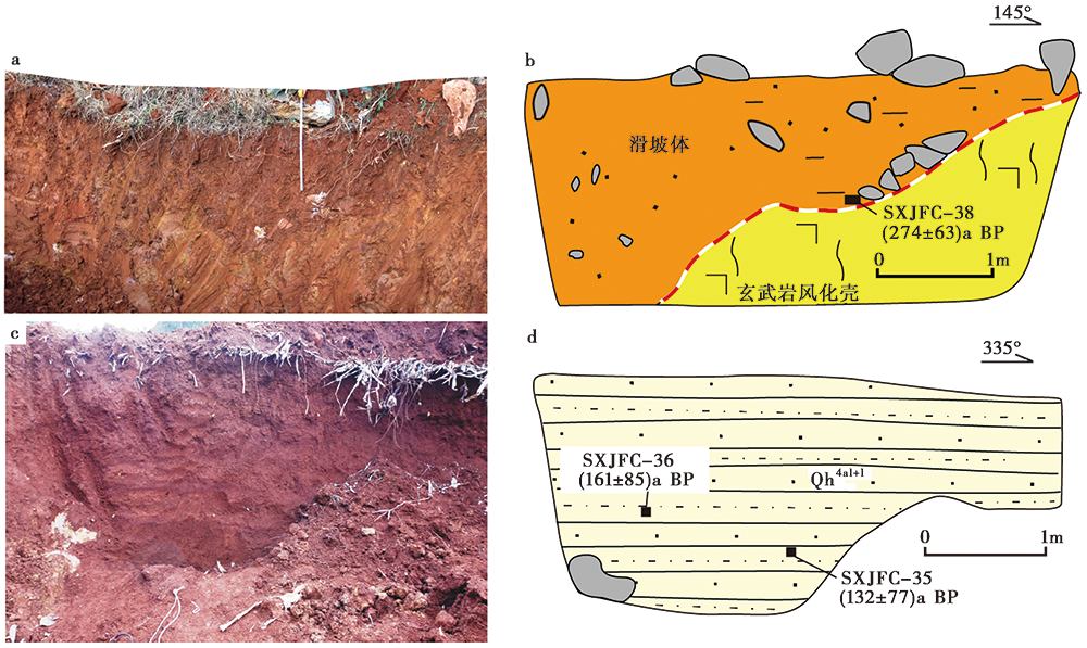
Fig. 9 Geological profile of Liangchahe landslide.
| 实验室编号 | 野外编号 | 测量文件号 | 样品物质 | 距今年代① /a | 树轮校正②(ca | |
|---|---|---|---|---|---|---|
| 区间 | μ±σ | |||||
| CG-2014-377 | SXJFC-35 | Wheel949 | 有机沉积物 | 115±20 | (10.5%)259~242 (6.0%)232~223 (9.3%)139~124 (36.1%)118~63 (6.3%)39~28 | 132±77 |
| CG-2014-378 | SXJFC-36 | Wheel949 | 有机沉积物 | 160±20 | (8.7%)277~266 (40.5%)218~173 (7.3%)151~143 (11.7%)22~9 | 161±85 |
| CG-2014-380 | SXJFC-38 | Wheel949 | 炭屑 | 250±20 | (68.2%)307~287 | 274±63 |
Table2 Dating results of trench samples from the Liangchahe landslide
| 实验室编号 | 野外编号 | 测量文件号 | 样品物质 | 距今年代① /a | 树轮校正②(ca | |
|---|---|---|---|---|---|---|
| 区间 | μ±σ | |||||
| CG-2014-377 | SXJFC-35 | Wheel949 | 有机沉积物 | 115±20 | (10.5%)259~242 (6.0%)232~223 (9.3%)139~124 (36.1%)118~63 (6.3%)39~28 | 132±77 |
| CG-2014-378 | SXJFC-36 | Wheel949 | 有机沉积物 | 160±20 | (8.7%)277~266 (40.5%)218~173 (7.3%)151~143 (11.7%)22~9 | 161±85 |
| CG-2014-380 | SXJFC-38 | Wheel949 | 炭屑 | 250±20 | (68.2%)307~287 | 274±63 |
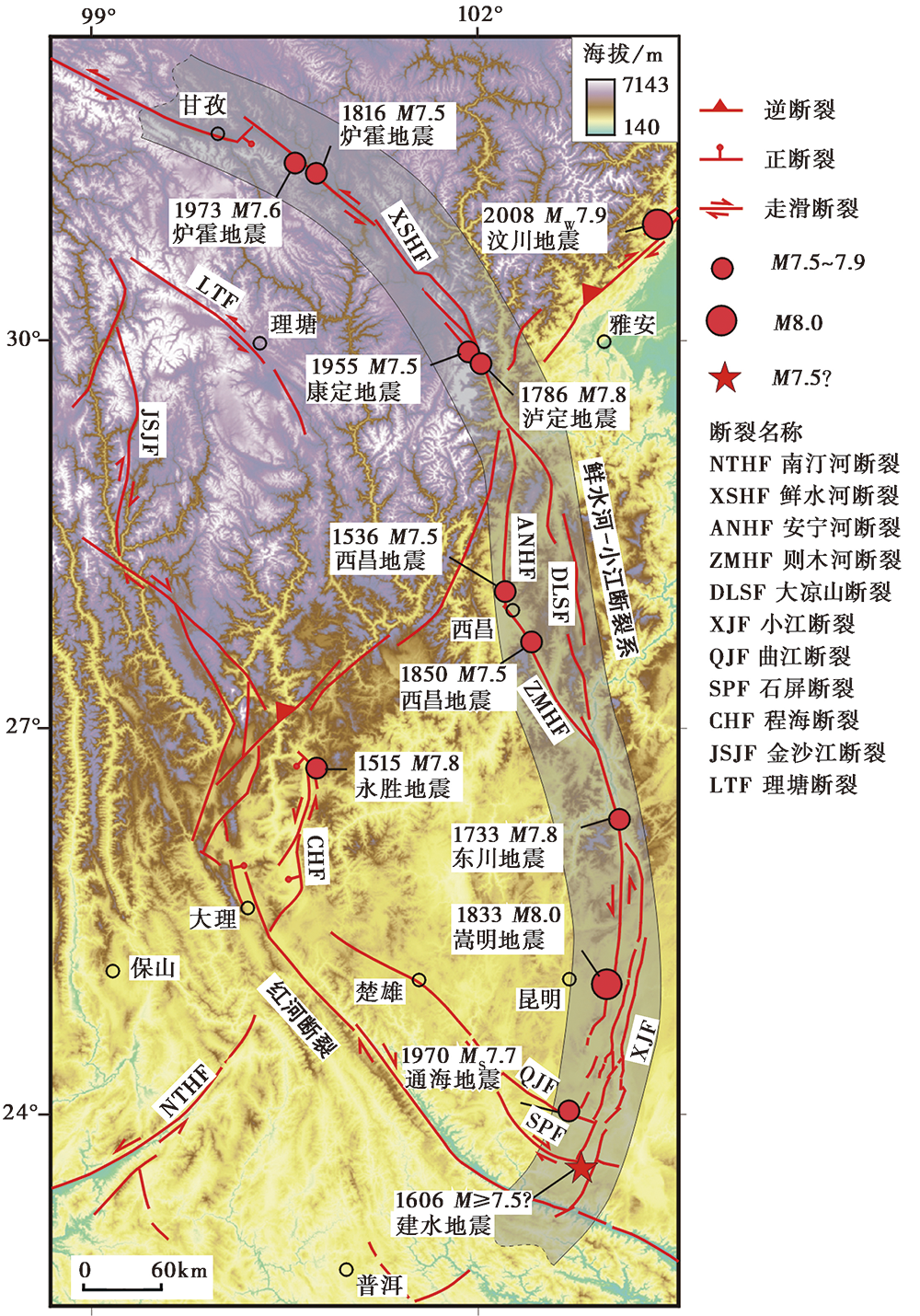
Fig. 10 Map showing the Xianshuihe-Xiaojiang fault system and epicenter distribution of M≥7.5 earthquakes.
| [1] | 陈立德. 1988. 1970年1月5日云南省通海7.7级地震[M]∥张肇诚. 中国震例(1966-1975). 北京: 地震出版社:57-76. |
| CHEN Li-de. 1988. The MS7.7 Tonghai earthquake in Yunnan Province on January 5, 1970[M]∥ ZHANG Zhao-cheng. Earthquake Cases in China(1966-1975). Seismological Press, Beijing: 57-76(in Chinese). | |
| [2] | 陈晓利, 张凌, 王明明. 2018. 基于地震滑坡敏感性分析的同震滑坡分布格局- -以2014年 MS6.5 鲁甸地震诱发滑坡为例[J]. 地震地质, 40(5): 1129-1139. |
| CHEN Xiao-li, ZHANG Ling, WANG Ming-ming. 2018. Study on the distribution pattern of earthquake triggered landslides based on seismic landslide susceptibility analysis: A case study of landslides triggered by the MS6.5 Ludian earthquake in 2014[J]. Seismology and Geology, 40(5): 1129-1139(in Chinese). | |
| [3] | 崔效锋, 谢富仁, 张红艳. 2006. 川滇地区现代构造应力场分区及动力学意义[J]. 地震学报, 28(5): 451-461. |
| CUI Xiao-feng, XIE Fu-ren, ZHANG Hong-yan. 2006. Recent tectonic stress field zoning in Sichuan-Yunnan region and its dynamic interest[J]. Acta Seismologica Sinica, 28(5): 451-461(in Chinese). | |
| [4] | 邓起东. 2008. 关于四川汶川8.0级地震的思考[J]. 地震地质, 30(4): 811-827. |
| DENG Qi-dong. 2008. Some thoughts on the MS8.0 Wenchuan, Sichuan earthquake[J]. Seismology and Geology, 30(4): 811-827(in Chinese). | |
| [5] | 顾功叙. 1983. 中国地震目录(公元前1831年-公元1969年)[Z]. 北京: 科学出版社. |
| GU Gong-xu. 1983. Catalogue of Chinese Earthquakes(1831BC-1969AD)[Z]. Science Press, Beijing(in Chinese). | |
| [6] | 国家地震局震害防御司. 1995. 中国历史强震目录(公元前23世纪-公元1911年)[Z]. 北京: 地震出版社. |
| Department of Earthquake Disaster Prevention, State Seismological Bureau, 1995. Catalogue of Chinese Historical Strong Earthquakes(23rd century BC-1911AD)[Z]. Seismological Press, Beijing(in Chinese). | |
| [7] | 虢顺民. 2001. 红河活动断裂带[M]. 北京: 海洋出版社. |
| GUO Shun-min. 2001. Red River Active Fault Zone[M]. China Ocean Press, Beijing(in Chinese). | |
| [8] | 韩竹军, 董绍鹏, 毛泽斌, 等. 2017. 小江断裂带南段全新世活动的地质地貌证据与滑动速率[J]. 地震地质, 39(1): 1-19. |
| HAN Zhu-jun, DONG Shao-peng, MAO Ze-bin, et al. 2017. The Holocene activity and strike-slip rate of the southern segment of Xiaojiang Fault in the southeastern Yunnan region, China[J]. Seismology and Geology, 39(1): 1-19(in Chinese). | |
| [9] | 何宏林, 池田安隆, 宋方敏, 等. 2002. 小江断裂带第四纪晚期左旋走滑速率及其构造意义[J]. 地震地质, 24(1): 14-26. |
| HE Hong-lin, Ikeda Y, SONG Fang-min, et al. 2002. Late Quaternary slip rate of the Xiaojiang Fault and its implication[J]. Seismology and Geology, 24(1): 14-26(in Chinese). | |
| [10] | 何宏林, 方仲景, 李玶. 1993. 小江断裂带西支断裂南段新活动初探[J]. 地震研究, 16(3): 291-298. |
| HE Hong-lin, FANG Zhong-jing, LI Ping. 1993. A preliminary approach to the fault activity of southern segment on Xiaojiang west branch fault[J]. Journal of Seismological Research, 16(3): 291-298(in Chinese). | |
| [11] | 何宏林, 李玶, 方仲景. 1992. 滇东南楔形构造区发震构造背景探讨[J]. 地震地质, 14(3): 217-226. |
| HE Hong-lin, LI Ping, FANG Zhong-jing. 1992. Analysis of seismogenic condition in the wedge tectonic region of southeast Yunnan Province[J]. Seismology and Geology, 14(3): 217-226(in Chinese). | |
| [12] | 呼楠, 韩竹军. 2013. 滇东南弧形构造带现今活动性质的地震学研究[J]. 地震地质, 35(1): 1-21. |
| HU Nan, HAN Zhu-jun. 2013. Seismological study on behaviors of present-day movement of arcuate tectonic belt in southeast Yunnan[J]. Seismology and Geology, 35(1): 1-21(in Chinese). | |
| [13] | 胡聿贤, 周锡元. 1999. 地震工程的跨世纪发展趋势[J]. 工程抗震, (1): 3-5. |
| HU Yu-xian, ZHOU Xi-yuan. 1999. Development trend of earthquake engineering toward new century[J]. Earthquake Resistant Engineering, (1): 3-5(in Chinese). | |
| [14] | 皇甫岗, 罗荣联. 2008. 运用历史地震资料重在考证[J]. 地震研究, 31(4): 304-307. |
| HUANGFU Gang, LUO Rong-lian. 2008. Importance of textual researches in the use of historical earthquake data[J]. Journal of Seismological Research, 31(4): 304-307(in Chinese). | |
| [15] | 阚荣举, 张四昌, 晏凤桐, 等. 1977. 我国西南地区现代构造应力场与现代构造活动特征的探讨[J]. 地球物理学报, 20(2): 96-109. |
| KAN Rong-ju, ZHANG Si-chang, YAN Feng-tong, et al. 1977. Discussion on modern tectonic stress field and characteristics of modern tectonic activity in Southwest China[J]. Chinese Journal of Geophysics, 20(2): 96-109(in Chinese). | |
| [16] | 李玶. 1993. 鲜水河-小江断裂带[M]. 北京: 地震出版社. |
| LI Ping. 1993. Xianshuihe-Xiaojiang Fault[M]. Seismological Press, Beijing(in Chinese). | |
| [17] | 李西, 冉勇康, 陈立春, 等. 2016. 红河断裂带南段全新世地震活动证据[J]. 地震地质, 38(3): 596-604. |
| LI Xi, RAN Yong-kang, CHEN Li-chun, et al. 2016. The Holocene seismic evidence on southern segment of the Red River fault zone[J]. Seismology and Geology, 38(3): 596-604(in Chinese). | |
| [18] | 刘祖荫, 皇甫岗, 金志林. 1999. 一九七〇年通海地震[M]. 北京: 地震出版社. |
| LIU Zu-yin, HUANGFU Gang, JIN Zhi-lin. 1999. The 1970 Tonghai Earthquake[M]. Seismological Press, Beijing(in Chinese). | |
| [19] | 宋方敏, 汪一鹏, 俞维贤. 1998. 小江活动断裂带[M]. 北京: 地震出版社. |
| SONG Fang-min, WANG Yi-peng, YU Wei-xian. 1998. Xiaojiang Active Fault Zone[M]. Seismological Press, Beijing(in Chinese). | |
| [20] | 唐渊, 刘俊来, Tran M, 等. 2009. 奠边府走滑断裂带的构造特征、 遥感解译及其区域构造意义[J]. 地质学报, 83(10): 1401-1414. |
| TANG Yuan, LIU Jun-lai, Tran M, et al. 2009. Structural characteristics of the Dien Bien Phu strike-slip fault zone and its regional tectonic implication[J]. Acta Geologica Sinica, 83(10): 1401-1414(in Chinese). | |
| [21] | 王椿镛, 朱成男, 刘玉权. 1978. 用地形变资料测定通海地震的地震断层参数[J]. 地球物理学报, 21(3): 191-198. |
| WANG Chun-yong, ZHU Cheng-nan, LIU Yu-quan. 1978. Determination of earthquake fault parameter for the Tonghai earthquake from ground deformation data[J]. Chinese Journal of Geophysics, 21(3): 191-198(in Chinese). | |
| [22] | 王阎昭, 王恩宁, 沈正康, 等. 2008. 基于GPS 资料约束反演川滇地区主要断裂现今活动速率[J]. 中国科学(D辑), 38(5): 582-597. |
| WANG Yan-zhao, WANG En-ning, SHEN Zheng-kang, et al. 2008. GPS-constrained inversion of present-day slip rates along major faults of the Sichuan-Yunnan region, China[J]. Science in China(Ser D), 38(5): 582-597(in Chinese). | |
| [23] | 闻学泽. 2000. 四川西部鲜水河-安宁河-则木河断裂带的地震破裂分段特征[J]. 地震地质, 22(3): 239-246. |
| WEN Xue-ze. 2000. Character of rupture segmentation of the Xianshuihe-Anninghe-Zemuhe fault zone, western Sichuan[J]. Seismology and Geology, 22(3): 239-246(in Chinese). | |
| [24] | 闻学泽, 杜方, 龙锋, 等. 2011. 小江和曲江-石屏两断裂系统的构造动力学与强震序列的关联性[J]. 中国科学(D辑), 41(5): 713-724. |
| WEN Xue-ze, DU Fang, LONG Feng, et al. 2011. Tectonic dynamics and correlation of major earthquake sequences of the Xiaojiang and Qujiang-Shiping fault systems, Yunnan, China[J]. Science in China(Ser D), 41(5): 713-724(in Chinese). | |
| [25] | 吴清, 高孟潭, 徐伟进. 2012. 历史强震震中精度统计特征及其对地震危险性研究的影响[J]. 地震学报, 34(4): 537-548. |
| WU Qing, GAO Meng-tan, XU Wei-jin. 2012. Statistical feature of epicenter accuracy of historical strong earthquakes and its effect on seismic hazard study[J]. Acta Seismologica Sinica, 34(4): 537-548(in Chinese). | |
| [26] | 吴中海, 龙长兴, 范桃园, 等. 2015. 青藏高原东南缘弧形旋扭活动构造体系及其动力学特征与机制[J]. 地质通报, 34(1): 1-31. |
| WU Zhong-hai, LONG Chang-xing, FAN Tao-yuan, et al. 2015. The arc rotational-shear active tectonic system on the southeastern margin of Tibetan plateau and its dynamic characteristics and mechanism[J]. Geological Bulletin of China, 34(1): 1-31(in Chinese). | |
| [27] | 谢毓寿, 蔡美彪. 1987. 中国地震历史资料汇编(第三卷)[M]. 北京: 科学出版社. |
| XIE Yu-shou, CAI Mei-biao. 1987. Compilation of Chinese Historical Earthquakes Data(Volume Three)[M]. Science Press, Beijing(in Chinese). | |
| [28] | 徐锡伟, 韩竹军, 杨晓平, 等. 2016. 中国及邻区地震构造图[CM]. 北京: 地震出版社. |
| XU Xi-wei, HAH Zhu-jun, YANG Xiao-ping, et al. 2016. Seismic Tectonic Map of China and Its Adjacent Areas [CM]. Seismological Press, Beijing(in Chinese). | |
| [29] | 徐锡伟, 闻学泽, 郑荣章, 等. 2003. 川滇地区活动块体最新构造变动样式及其动力来源[J]. 中国科学(D辑), 33(S1): 151-162. |
| XU Xi-wei, WEN Xue-ze, ZHENG Rong-zhang, et al. 2003. Pattern of latest tectonic motion and its dynamics for active blocks in Sichuan-Yunnan region, China[J]. Science in China(Ser D), 33(S1): 151-162(in Chinese). | |
| [30] | 殷跃平. 2008. 汶川八级地震地质灾害研究[J]. 工程地质学报, 16(4): 433-444. |
| YIN Yue-ping. 2008. Researches on the geo-hazards triggered by Wenchuan earthquake, Sichuan[J]. Journal of Engineering Geology, 16(4): 433-444(in Chinese). | |
| [31] | 袁道阳, 杨青云, 雷中生, 等. 2016. 四川北部地区3次中强历史地震补充考证[J]. 地震工程学报, 38(2): 226-235. |
| YUAN Dao-yang, YANG Qing-yun, LEI Zhong-sheng, et al. 2016. Additional textual criticism of three moderate-strong historical earthquakes in the northern region of Sichuan Province[J]. China Earthquake Engineering Journal, 38(2): 226-235(in Chinese). | |
| [32] | 袁仁茂, 谭锡斌, 陈桂华, 等. 2010. 地震破裂带特殊部位大型滑坡及其基于构造地貌发生模型的机制解释: 以东河口抛射型滑坡为例[J]. 地学前缘, 17(5): 243-253. |
| YUAN Ren-mao, TAN Xi-bin, CHEN Gui-hua, et al. 2010. Huge landslides occurred at the special places of the coseismic rupture and their mechanism explanation based on the formation model of tectonic-geomorphology: A case study of Donghekou ejection landslide[J]. Earth Science Frontiers, 17(5): 243-253(in Chinese). | |
| [33] | 张俊昌. 1979. 曲江断裂的新活动与通海地震[J]. 地震研究, 2(1): 38-43. |
| ZHANG Jun-chang. 1979. The new activities of Qujiang Fault and the Tonghai earthquake[J]. Journal of Seismological Research, 2(1): 38-43(in Chinese). | |
| [34] |
Allen C R, Gillespie A R, Yuan H, et al. 1984. Red River and associated faults, Yunnan Province, China: Quaternary geology, slip rates, and seismic hazard[J]. The Geological Society of America Bulletin, 95(6): 686-700.
DOI URL |
| [35] |
Bucknam R C, Anderson R E. 1979. Estimation of fault-scarp ages from a scarp-height-slope-angle relationship[J]. Geology, 7(1): 11-14.
DOI URL |
| [36] | Chen X L, Yu L, Wang M M, et al. 2013. Brief communication: Landslides triggered by the MS=7.0 Lushan earthquake, China[J]. Natural Hazards and Earth System Sciences, 1(4): 3891-3918. |
| [37] |
Guidoboni E, Ferrari G, Tarabusi G, et al. 2019. CFTI5Med, the new release of the catalogue of strong earthquakes in Italy and in the Mediterranean area[J]. Scientific Data, 6(1): 1-15.
DOI URL |
| [38] | Guo P, Han Z J, Dong S P, et al. 2021. Latest Quaternary active faulting and paleoearthquakes on the southern segment of the Xiaojiang fault zone, SE Tibetan plateau[J]. Lithosphere, (1): 7866379. |
| [39] |
Guo P, Han Z J, Ran H L, et al. 2019. Co-seismic surface rupture of Papatea Fault and reactivation mechanism of the Clarence landslide during the 2016 MW7.8 Kaikoura earthquake, New Zealand[J]. Bulletin of Engineering Geology and the Environment, 78(5): 3055-3068.
DOI URL |
| [40] |
Marco S, Hartal M, Hazan N,et al. 2003. Archaeology, history, and geology of the AD 749 earthquake, Dead Sea transform[J]. Geology, 31(8): 665-668.
DOI URL |
| [41] | McCalpin J P, Nishenko S P. 1996. Holocene paleoseismicity, temporal clustering, and probabilities of future large(M>7)earthquakes on the Wasatch fault zone, Utah[J]. Journal of Geophysical Research: Solid Earth, 101(B3): 6233-6253. |
| [42] |
Meghraoui M, Crone A J. 2001. Earthquakes and their preservation in the geological record[J]. Journal of Seismology, 5:281-285.
DOI URL |
| [43] |
Michel G W, Becker M, Angermann D, et al. 2000. Crustal motion in E- and SE-Asia from GPS measurements[J]. Earth Planets and Space, 52(10): 713-720.
DOI URL |
| [44] |
Ramsey C B. 2009. Bayesian analysis of radiocarbon dates[J]. Radiocarbon, 51(1): 337-360.
DOI URL |
| [45] |
Reimer P J, Bard E, Bayliss A, et al. IntCal13 and Marine13 radiocarbon age calibration curves 0-50 000 years cal BP[J]. Radiocarbon, 55(4): 1869-1887.
DOI URL |
| [46] | Replumaz A, Lacassin R, Tapponnier P, et al. 2001. Large river offsets and Plio-Quaternary dextral slip rate on the Red River Fault(Yunnan, China)[J]. Journal of Geophysical Research: Solid Earth, 106(B1): 819-836. |
| [47] |
Schoenbohm L M, Burchfiel B C, Liangzhong C, et al. 2006. Miocene to present activity along the Red River Fault, China, in the context of continental extrusion, upper-crustal rotation, and lower-crustal flow[J]. Geological Society of America Bulletin, 118(5-6): 672-688.
DOI URL |
| [48] |
Shen J, Wang Y P, Song F M. 2003. Characteristics of the active Xiaojiang fault zone in Yunnan, China: A slip boundary for the southeastward escaping Sichuan-Yunnan block of the Tibetan plateau[J]. Journal of Asian Earth Sciences, 21(10): 1085-1096.
DOI URL |
| [49] | Shen Z K, Lu J, Wang M, et al. 2005. Contemporary crustal deformation around the southeast borderland of the Tibetan plateau[J]. Journal of Geophysical Research: Solid Earth, 110(B11): 1-17. |
| [50] |
Tapponnier P, Molnar P. 1977. Active faulting and tectonics in China[J]. Journal of Geophysical Research, 82(20): 2905-2930.
DOI URL |
| [51] |
Wallace R E. 1977. Profiles and ages of young fault scarps in north-central Nevada[J]. Geological Society of America Bulletin, 88(9): 1267-1281.
DOI URL |
| [52] | Wang E, Burchfiel B C, Royden L H, et al. 1998. Late Cenozoic Xianshuihe-Xiaojiang, Red River, and Dali fault systems of southwestern Sichuan and central Yunnan, China[J]. Special Paper of the Geological Society of America, Inc, Boulder, USA. |
| [53] |
Wang P F, Chen J, Dai F C, et al. 2014. Chronology of relict lake deposits around the Suwalong paleolandslide in the upper Jinsha River, SE Tibetan plateau: Implications to Holocene tectonic perturbations[J]. Geomorphology, 217:193-203.
DOI URL |
| [54] |
Wang P, Zhang B, Qiu W L, et al. 2011. Soft-sediment deformation structures from the Diexi paleo-dammed lakes in the upper reaches of the Minjiang River, east Tibet[J]. Journal of Asian Earth Sciences, 40(4): 865-872.
DOI URL |
| [55] | Wells D L, Coppersmith K J. 1994. New empirical relationships among magnitude, rupture length, rupture width, rupture area, and surface displacement[J]. Bulletin of the Seismological Society of America, 84(4): 974-1002. |
| [56] |
Xiong J G, Li Y L, Zhong Y Z, et al. 2016. Paleomagnetism of the Jianshui Basin in Yunnan, SW China, and geomorphological evolution of the Yunnan Plateau since the Neogene[J]. Journal of Asian Earth Sciences, 123:67-77.
DOI URL |
| [57] |
Xu C, Xu X W, Yao X, et al. 2013. Three(nearly)complete inventories of landslides triggered by the May 12, 2008 Wenchuan MW7.9 earthquake of China and their spatial distribution statistical analysis[J]. Landslides, 10(4): 421-431.
DOI URL |
| [58] |
Yuan R M, Deng Q H, Cunningham D, et al. 2013. Density distribution of landslides triggered by the 2008 Wenchuan earthquake and their relationships to peak ground acceleration[J]. Bulletin of the Seismological Society of America, 103(4): 2344-2355.
DOI URL |
| [59] | Yuan R M, Tang C L, Hu J C, et al. 2014. Mechanism of the Donghekou landslide triggered by the 2008 Wenchuan earthquake revealed by discrete element modeling[J]. Natural Hazards and Earth System Sciences, 14(5): 1195-1205. |
| [60] |
Zhang P Z, Shen Z K, Wang M, et al. 2004. Continental deformation of the Tibetan plateau from global positioning system data[J]. Geology, 32(9): 809-812.
DOI URL |
| [61] |
Zuchiewicz W, Cuong N Q, Bluszcz A, et al. 2004. Quaternary sediments in the Dien Bien Phu fault zone, NW Vietnam: A record of young tectonic processes in the light of OSL-SAR dating results[J]. Geomorphology, 60(3-4): 269-302.
DOI URL |
| [1] | LIU Bai-yun, ZHAO Li, LIU Yun-yun, WANG Wen-cai, ZHANG Wei-dong. THE RESEARCH ON RELOCATION AND FAULT PLANE SOLUTION AND GEOMETRIC MEANING OF THE MADUO M7.4 EARTHQUAKE ON 22 MAY 2021 [J]. SEISMOLOGY AND GEOLOGY, 2023, 45(2): 500-516. |
| [2] | ZHAO De-zheng, QU Chun-yan, ZHANG Gui-fang, GONG Wen-yu, SHAN Xin-jian, ZHU Chuan-hua, ZHANG Guo-hong, SONG Xiao-gang. APPLICATIONS AND ADVANCES FOR THE COSEISMIC DEFORMA-TION OBSERVATIONS, EARTHQUAKE EMERGENCY RESPONSE AND SEISMOGENIC STRUCTURE INVESTIGATION USING INSAR [J]. SEISMOLOGY AND GEOLOGY, 2023, 45(2): 570-592. |
| [3] | ZHANG Ke, WANG Xin, YANG Hong-ying, WANG Yue, XU Yan, LI Jing. THE CHARACTERISTICS AND SEISMOGENIC STRUCTURE ANALYSIS OF THE 2021 YANGBI MS6.4 EARTHQUAKE SEQUENCE, YUNNAN [J]. SEISMOLOGY AND GEOLOGY, 2023, 45(1): 231-251. |
| [4] | LI Chuan-you, SUN Kai, MA Jun, LI Jun-jie, LIANG Ming-jian, FANG Li-hua. THE 2022 M6.8 LUDING EARTHQUAKE: A COMPLICATED EVENT BY FAULTING OF THE MOXI SEGMENT OF THE XIANSHUIHE FAULT ZONE [J]. SEISMOLOGY AND GEOLOGY, 2022, 44(6): 1648-1666. |
| [5] | ZHANG Bo-xuan, ZHENG Wen-jun, CHEN Jie, HE Xiao-hui, LI Qi-lei, ZHANG Dong-li, DUAN Lei, CHEN Gan. ANALYSIS OF THE SEISMOGENIC STRUCTURE OF THE JUNE 2021 MS5.8 MANG’AI EARTHQUAKE IN NORTHERN QAIDAM BASIN [J]. SEISMOLOGY AND GEOLOGY, 2022, 44(5): 1313-1332. |
| [6] | YAO Sheng-hai, GAI Hai-long, YIN Xiang, LIU Wei, ZHANG Jia-qing, YUAN Jian-xin. A DISCUSSION ON THE RELATIONSHIP BETWEEN THE SUR-FACE RUPTURE ZONE IN FRONT OF THE AMUNIKESHAN MOUNTAIN AND THE 1962 M6.8 EARTHQUAKE [J]. SEISMOLOGY AND GEOLOGY, 2022, 44(4): 976-991. |
| [7] | LIANG Kuan, HE Zhong-tai, JIANG Wen-liang, LI Yong-sheng, LIU Ze-min. SURFACE RUPTURE CHARACTERISTICS OF THE MENYUAN MS6.9 EARTHQUAKE ON JANUARY 8, 2022, QINGHAI PROVINCE [J]. SEISMOLOGY AND GEOLOGY, 2022, 44(1): 256-278. |
| [8] | YAO Sheng-hai, GAI Hai-long, YIN Xiang, LI Xin. THE BASIC CHARACTERISTICS AND TYPICAL PHENOMENA OF THE SURFACE RUPTURE ZONE OF THE MADUO MS7.4 EARTHQUAKE IN QINGHAI [J]. SEISMOLOGY AND EGOLOGY, 2021, 43(5): 1060-1072. |
| [9] | JIA Rui, ZHANG Guo-hong, XIE Chao-di, SHAN Xin-jian, ZHANG Ying-feng, LI Cheng-long, HUANG Zi-cheng. COSEISMIC DEFORMATION FIELD AND FAULT SLIP MODEL OF THE MW6.0 PAKISTAN EARTHQUAKE CONSTRAINED BY SENTINEL-1A SAR DATA [J]. SEISMOLOGY AND GEOLOGY, 2021, 43(3): 600-613. |
| [10] | ZHAO Qi-guang, SUN Ye-jun, HUANG Yun, YANG Wei-lin, GU Qin-ping, MENG Ke, YANG Hao. A STUDY ON THE SEISMOGENIC STRUCTURE OF GAOYOU-BAOYING MS4.9 EARTHQUAKE [J]. SEISMOLOGY AND GEOLOGY, 2021, 43(3): 630-646. |
| [11] | LI Qi-lei, LI Yu-li, TU Hong-wei, LIU Wen-bang. THE RELOCATION, FOCAL MECHANISMS OF THE DINGQING EARTHQUAKES AND A PRELIMINARY STUDY OF ITS SEISMOGENIC STRUCTURE [J]. SEISMOLOGY AND GEOLOGY, 2021, 43(1): 209-231. |
| [12] | LIU Bai-yun, YIN Zhi-wen, YUAN Dao-yang, LI Liang, WANG Wei-huan. THE RESEARCH ON FAULT PLANE SOLUTION AND GEOMETRIC MEANING OF THE LAOHUSHAN FAULT IN THE NORTHEASTERN TIBETAN PLATEAU [J]. SEISMOLOGY AND GEOLOGY, 2020, 42(6): 1354-1369. |
| [13] | WU Wei-wei, WEI Ya-ling, LONG Feng, LIANG Ming-jian, CHEN Xue-fen, SUN Wei, ZHAO Jing. STUDY ON SOURCE PARAMETERS OF THE 8 AUGUST 2017 M7.0 JIUZHAIGOU EARTHQUAKE AND ITS AFTERSHOCKS, NORTHERN SICHUAN [J]. SEISMOLOGY AND GEOLOGY, 2020, 42(2): 492-512. |
| [14] | MAO Ze-bin, CHANG Zu-feng, LI Jian-lin, CHANG Hao, ZHAO Jin-min, CHEN Gang. LATE QUATERNARY ACTIVITY OF FAULTS IN THE EPICENTER AREA OF JINGGU M6.6 EARTHQUAKE [J]. SEISMOLOGY AND GEOLOGY, 2019, 41(4): 821-836. |
| [15] | LI He, XIE Zu-jun, WANG Yi-xi, WANG Xiao-shan, DONG Yi-bing, ZHANG Hui, PENG Zhao, LIU Wen-bing, GAO Ye, WANG Li-xia. THE SOURCE PARAMETERS AND SEISMOTECTONIC IMPLICATIONS OF THE SEPTEMBER 4, 2017 ML4.4 LINCHENG EARTHQUAKE [J]. SEISMOLOGY AND GEOLOGY, 2019, 41(3): 670-689. |
| Viewed | ||||||
|
Full text |
|
|||||
|
Abstract |
|
|||||
