SEISMOLOGY AND GEOLOGY ›› 2022, Vol. 44 ›› Issue (4): 976-991.DOI: 10.3969/j.issn.0253-4967.2022.04.010
• Research paper • Previous Articles Next Articles
YAO Sheng-hai1)( ), GAI Hai-long1), YIN Xiang1), LIU Wei1), ZHANG Jia-qing1), YUAN Jian-xin2)
Received:2021-06-03
Revised:2021-08-17
Online:2022-08-20
Published:2022-09-23
姚生海1)(), 盖海龙1), 殷翔1), 刘炜1), 张加庆1), 袁建新2)
作者简介:姚生海, 男, 1980年生, 2003年于兰州大学获地质工程专业学士学位, 高级工程师, 主要从事活动构造和古地震研究, E-mail: shenghaiyao@sina.com。
基金资助:CLC Number:
YAO Sheng-hai, GAI Hai-long, YIN Xiang, LIU Wei, ZHANG Jia-qing, YUAN Jian-xin. A DISCUSSION ON THE RELATIONSHIP BETWEEN THE SUR-FACE RUPTURE ZONE IN FRONT OF THE AMUNIKESHAN MOUNTAIN AND THE 1962 M6.8 EARTHQUAKE[J]. SEISMOLOGY AND GEOLOGY, 2022, 44(4): 976-991.
姚生海, 盖海龙, 殷翔, 刘炜, 张加庆, 袁建新. 阿木尼克山山前地表破裂带与1962年6.8级地震关系的讨论[J]. 地震地质, 2022, 44(4): 976-991.
Add to citation manager EndNote|Ris|BibTeX
URL: https://www.dzdz.ac.cn/EN/10.3969/j.issn.0253-4967.2022.04.010
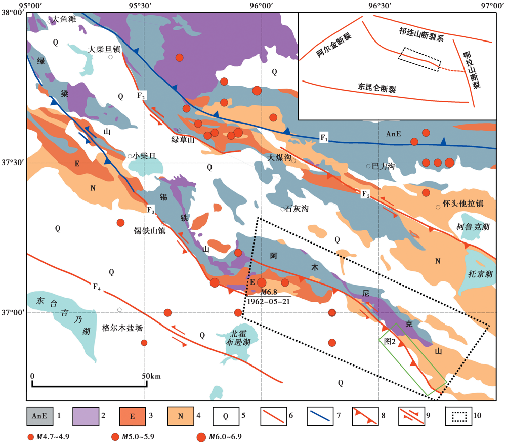
Fig. 1 Schematic geological structure of the research area.
Fig. 2 Amunikeshan mountain front images.
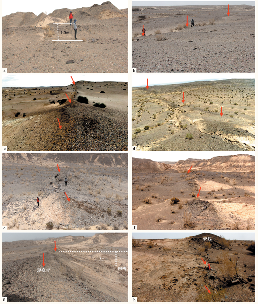
Fig. 3 Geomorphic characteristics of fault.
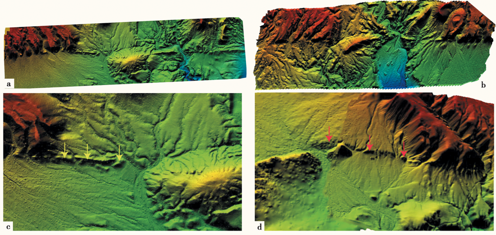
Fig. 4 Pressure ridge(a, c)and fault scarp(b, d)developed in Fan1 of the alluvial fan captured by UAV.
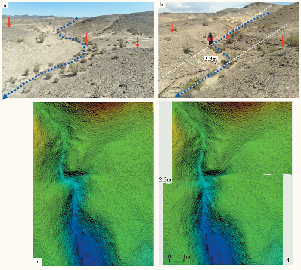
Fig. 5 Strike-slip water system along the fault.
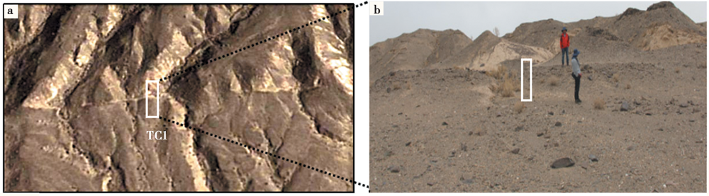
Fig. 6 Position map of Trench 1.
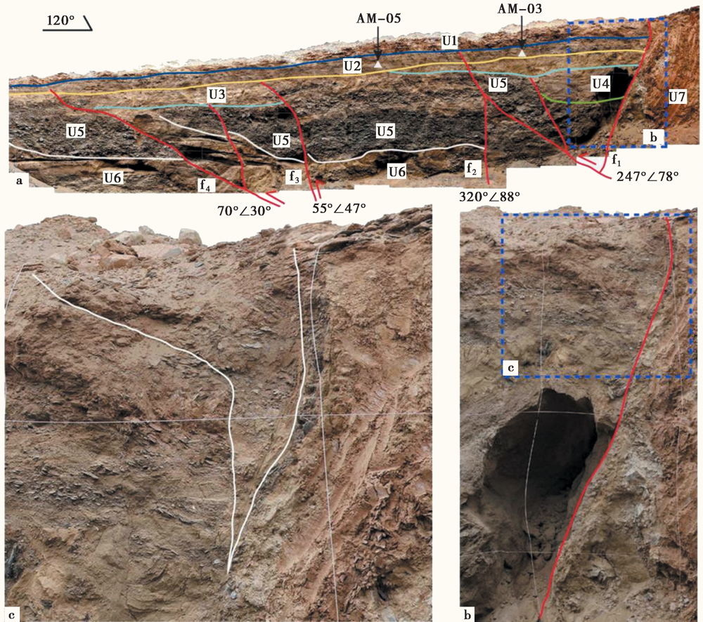
Fig. 7 Trench 1(TC1)profile interpretation.
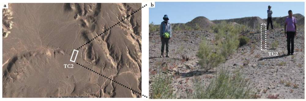
Fig. 8 Position of Trench 2.
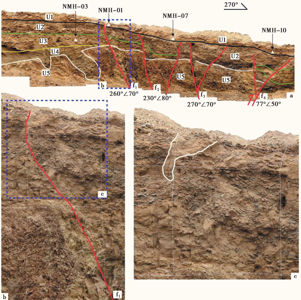
Fig. 9 Trench 2(TC2)profile interpretation.
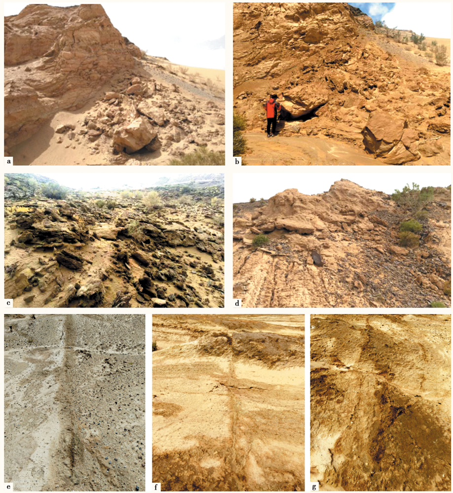
Fig. 10 Photos of earthquake geological disaster.
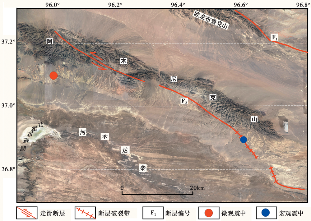
Fig. 11 Distribution map of the micro-epicenter and macro-epicenter of the M6.8 earthquake in 1962.
| 公式 | 震级/M | 破裂长度L/km | 同震位移D/m | 公式来源 |
|---|---|---|---|---|
| M=5.16+1.12logL | 6.66 | 22 | Wells et al., | |
| M=5.92+0.88logL | 7.10 | 22 | 邓起东等, | |
| M=5.303+1.181logL | 6.88 | 22 | 冉洪流, | |
| M=4.278+1.653logL | 6.50 | 22 | 丁国瑜等, | |
| 平均值 | 6.79 | |||
| logD=-1.791+0.324M | 6.64 | 2.3 | 冉洪流, | |
| logD=-3.37+0.53M | 7.04 | 2.3 | 邓起东等, | |
| logD=0.9M-6.32 | 7.42 | 2.3 | Wells et al., | |
| 平均值 | 7.03 |
Table 1 The rupture length and coseismic displacement of earthquakes derived by applying different empirical relations
| 公式 | 震级/M | 破裂长度L/km | 同震位移D/m | 公式来源 |
|---|---|---|---|---|
| M=5.16+1.12logL | 6.66 | 22 | Wells et al., | |
| M=5.92+0.88logL | 7.10 | 22 | 邓起东等, | |
| M=5.303+1.181logL | 6.88 | 22 | 冉洪流, | |
| M=4.278+1.653logL | 6.50 | 22 | 丁国瑜等, | |
| 平均值 | 6.79 | |||
| logD=-1.791+0.324M | 6.64 | 2.3 | 冉洪流, | |
| logD=-3.37+0.53M | 7.04 | 2.3 | 邓起东等, | |
| logD=0.9M-6.32 | 7.42 | 2.3 | Wells et al., | |
| 平均值 | 7.03 |
| [1] | 邓起东, 于贵华, 叶文华. 1992. 地震地表破裂参数与震级关系的研究[M]//国家地震局地质研究所编.活动断裂研究(2). 北京: 地震出版社: 247-264. |
| DENG Qi-dong, YU Gui-hua, YE Wen-hua. 1992. Study on the relations between parameters of surface rupture and magnitude [M]//Institute of Geology, SSB(ed).Research of Active Fault (2). Seismological Press, Beijing: 247-264. (in Chinese) | |
| [2] | 丁国瑜, 田勤俭, 孔凡臣, 等. 1993. 活断层分段:原则、方法与应用[M]. 北京: 地震出版社. |
| DING Guo-yu, TIAN Qin-jian, KONG Fan-chen, et al. 1993. Segmentation of Active Faults: Principles, Methods and Applications[M]. Seismological Press, Beijing. (in Chinese) | |
| [3] |
董金元, 李传友, 郑文俊, 等. 2019. 宗务隆山南缘断裂构造地貌特征与晚第四纪滑动速率[J]. 地震地质, 41(2): 341-362. doi: 10.3969/j.issn.0253-4967.2019.02.006.
DOI |
| DONG Jin-yuan, LI Chuan-you, ZHENG Wen-jun, et al. 2019. Geomorphic features and late Quaternary slip rate of the southern Zongwulong Shan Fault[J]. Seismology and Geology, 41(2): 341-362. (in Chinese) | |
| [4] | 都兰县县志编纂委员会. 2001. 都兰县志[M]. 陕西: 陕西省人民出版社. |
| County Annals Compilation Committee of Dulan County. 2001. Dulan County Chronicles[M]. Shaanxi People’s Publishing House, Xi'an. (in Chinese) | |
| [5] | 顾功叙. 1983. 中国地震目录(1831BC-1969AD)[Z]. 北京: 科学出版社: 496-497. |
| GU Gong-xu. 1983. Catalogue of Chinese Earthquake(1831BC-1969AD)[Z]. Science Press, Beijing: 496-497. (in Chinese) | |
| [6] | 马玉虎, 刘文邦, 王培玲, 等. 2012. 2008、2009年大柴旦6.3级、 6.4级地震序列活动特征及前兆异常[J]. 中国地震, 28(2): 188-199. |
| MA Yu-hu, LIU Wen-bang, WANG Pei-ling, et al. 2012. Characteristics and anomaly of earthquake sequence activity of Da Qaidam MS6.3 and MS6.4 in 2008 and 2009[J]. Earthquake Research in China, 28(2): 188-199. | |
| [7] | 庞炜, 何文贵, 袁道阳, 等. 2015. 青海大柴旦断裂古地震特征[J]. 地球科学与环境学报, 37(3): 87-103. |
| PANG Wei, HE Wen-gui, YUAN Dao-yang, et al. 2015. Paleoseismic characteristics of Dachaidan Fault in Qinghai[J]. Journal of Earth Sciences and Environment, 37(3): 87-103. (in Chinese) | |
| [8] | 冉洪流. 2011. 中国西部走滑型活动断裂的地震破裂参数与震级的经验关系[J]. 地震地质, 33(3): 577-585. |
| RAN Hong-liu. 2011. Empirical relations between earthquake magnitude and parameters of strike-slip seismogenic active fault associated with historical earthquakes in western China[J]. Seismology and Geology, 33(3): 577-585. (in Chinese) | |
| [9] | 孙长虹, 许丰, 杨玉波, 等. 2012. 2003年青海德令哈6.7级地震序列的震源机制解及其构造含义[J]. 地球物理学报, 55(10): 3338-3346. |
| SUN Chang-hong, XU Feng, YANG Yu-bo, et al. 2012. Focal mechanism solution of 2003 Delingha, Qinghai, M6.7 earthquake sequence and its tectonic implication[J]. Chinese Journal of Geophysics, 55(10): 3338-3346. (in Chinese) | |
| [10] | 汤良杰, 金之钧, 戴俊生, 等. 2002. 柴达木盆地及相邻造山带区域断裂系统[J]. 地球科学(中国地质大学学报), 27(6): 676-682. |
| TANG Liang-jie, JIN Zhi-jun, DAI Jun-sheng, et al. 2002. Regional fault systems of the Qaidam Basin and adjacent orogenic belts[J]. Earth Science(Journal of China University of Geosciences), 27(6): 676-682. (in Chinese) | |
| [11] | 温少妍, 单新建, 张迎峰, 等. 2016. 基于InSAR的青海大柴旦地震三维同震形变场获取与震源特征分析[J]. 地球物理学报, 59(3): 912-921. |
| WEN Shao-yan, SHAN Xin-jian, ZHANG Ying-feng, et al. 2016. Three-dimensional co-seismic deformation of the Da Qaidam, Qinghai earthquakes derived from D-InSAR data and their source features[J]. Chinese Journal of Geophysics, 59(3): 912-921. (in Chinese) | |
| [12] | 杨丽萍, 苏旭. 2017. 德令哈市活断层探测与地震危险性评[M]. 北京: 地震出版社. |
| YANG Li-ping, SU Xu. 2017. Active Fault Detection and Seismic Risk Assessment in Delingha City[M]. Seismological Press, Beijing. (in Chinese) | |
| [13] |
姚生海, 盖海龙, 殷翔, 等. 2020a. 柴达木盆地北缘断裂(锡铁山段)的构造地貌特征与晚第四纪活动速率[J]. 地震地质, 42(6): 1385-1400. doi: 10.3969/j.issn.0253-4967.2020.06.008.
DOI |
| YAO Sheng-hai, GAI Hai-long, YIN Xiang, et al. 2020a. Tectonic geomorphology and Quaternary slip-rate of the Xitieshan section of the northern margin fault of Qaidam Basin[J]. Seismology and Geology, 42(6): 1385-1400. (in Chinese) | |
| [14] | 姚生海, 盖海龙, 刘炜, 等. 2020b. 柴达木盆地北缘断裂(阿木尼克山段)构造地貌及晚第四纪活动速率研究[J]. 第四纪研究, 40(5): 1312-1322. |
| YAO Sheng-hai, GAI Hai-long, LIU Wei, et al. 2020b. Tectonic geomorphology and late Quaternary slip rate of the Amunike segment, The north Qaidam thrust fault zone[J]. Quaternary Sciences, 40(5): 1312-1322. (in Chinese) | |
| [15] | 姚生海, 黄伟, 姜文亮, 等. 2014a. 大柴旦-托素湖断裂带遥感解译及其晚更新世活动特征研究[J]. 地震研究, 37(S1): 55-60. |
| YAO Sheng-hai, HUANG Wei, JIANG Wen-liang, et al. 2014a. Research on the remote sensing interpretation and active characteristics of Dachaidan-Tuosu Lake fault belt in Late Pleistocene[J]. Journal of Seismological Research, 37(S1): 55-60. | |
| [16] | 姚生海, 黄伟, 姜文亮, 等. 2014b. 柴达木盆地北缘断裂(锡铁山段)晚第四纪活动性特征[J]. 地震研究, 37(S1), 50-54. |
| YAO Sheng-hai, HUANG wei, JIANG Wen-liang, et al. 2014b. Activity characteristic of northern margin fault at Qaidam Basin(Xitie Mountain segment)in Late Quaternary[J]. Journal of Seismological Research, 37(S1): 50-54. (in Chinese) | |
| [17] | 袁道阳, 张培震, 刘百篪, 等. 2004. 青藏高原东北缘晚第四纪活动构造的几何图像与构造转换[J]. 地质学报, 78(2): 270-278. |
| YUAN Dao-yang, ZHANG Pei-zhen, LIU Bai-chi, et al. 2004. Geometrical imagery and tectonic transformation of Late Quaternary active tectonics in northeastern margin of Qinghai-Xizang Plateau[J]. Acta Geologica Sinica, 78(2): 270-278. (in Chinese) | |
| [18] | 叶建青. 1992. 一九九一年九月二日锡铁山MS=5.1地震考察[J]. 高原地震, 3(1): 63-68. |
| YE Jian-qing. 1992. Investigation of Xi Tie Mountain earthquake MS=5.1 on Sept.2, 1991[J]. Plateau Earthquake Research, 3(1): 63-68. | |
| [19] | Elliott J R, Parsons B, Jackson J A, et al. 2011. Depth segmentation of the seismogenic continental crust: The 2008 and 2009 Qaidam earthquakes[J]. Geophysical Research Letters, 38(6): L06305. http://doi.org/10.1029/2011GL046897. |
| [20] | Wells D L, Coppersmiths K J. 1994. New empirical relations among magnitude, rupture length, rupture width, rupture area and surface displacement[J]. Bulletin of the Seismological Society of America, 84(4): 974-1002. |
| [1] | WANG Liao, XIE Hong, YUAN Dao-yang, LI Zhi-min, XUE Shan-yu, SU Rui-huan, WEN Ya-meng, SU Qi. THE SURFACE RUPTURE CHARACTERISTICS BASED ON THE GF-7 IMAGES INTERPRETATION AND THE FIELD INVESTIGA-TION OF THE 2022 MENYUAN MS6.9 EARTHQUAKE [J]. SEISMOLOGY AND GEOLOGY, 2023, 45(2): 401-421. |
| [2] | LIU Bai-yun, ZHAO Li, LIU Yun-yun, WANG Wen-cai, ZHANG Wei-dong. THE RESEARCH ON RELOCATION AND FAULT PLANE SOLUTION AND GEOMETRIC MEANING OF THE MADUO M7.4 EARTHQUAKE ON 22 MAY 2021 [J]. SEISMOLOGY AND GEOLOGY, 2023, 45(2): 500-516. |
| [3] | ZHAO De-zheng, QU Chun-yan, ZHANG Gui-fang, GONG Wen-yu, SHAN Xin-jian, ZHU Chuan-hua, ZHANG Guo-hong, SONG Xiao-gang. APPLICATIONS AND ADVANCES FOR THE COSEISMIC DEFORMA-TION OBSERVATIONS, EARTHQUAKE EMERGENCY RESPONSE AND SEISMOGENIC STRUCTURE INVESTIGATION USING INSAR [J]. SEISMOLOGY AND GEOLOGY, 2023, 45(2): 570-592. |
| [4] | ZHANG Ke, WANG Xin, YANG Hong-ying, WANG Yue, XU Yan, LI Jing. THE CHARACTERISTICS AND SEISMOGENIC STRUCTURE ANALYSIS OF THE 2021 YANGBI MS6.4 EARTHQUAKE SEQUENCE, YUNNAN [J]. SEISMOLOGY AND GEOLOGY, 2023, 45(1): 231-251. |
| [5] | WU Zhong-hai, Baima Duoji, YE Qiang, HAN Shuai, SHI Ya-ran, Nima Ciren, GAO Yang. THE QUATERNARY NORMAL FAULTING AND RECENT CO-SEISMIC SURFACE RUPTURE AND RELATED SEISMOLOGICAL SIGNIFICANCE ALONG THE ARU CO GRABEN SYSTEM IN NORTHERN NGARI, TIBET [J]. SEISMOLOGY AND GEOLOGY, 2023, 45(1): 67-91. |
| [6] | LI Dong-chen, REN Jun-jie, ZHANG Zhi-wen, LIU Liang. RESEARCH ON SEMI-AUTOMATIC EXTRACTION METHOD OF SEISMIC SURFACE RUPTURES BASED ON HIGH-RESOLUTION UAV IMAGE: TAKING THE 2021 MS7.4 MADUO EARTHQUAKE IN QINGHAI PROVINCE AS AN EXAMPLE [J]. SEISMOLOGY AND GEOLOGY, 2022, 44(6): 1484-1502. |
| [7] | LI Chuan-you, SUN Kai, MA Jun, LI Jun-jie, LIANG Ming-jian, FANG Li-hua. THE 2022 M6.8 LUDING EARTHQUAKE: A COMPLICATED EVENT BY FAULTING OF THE MOXI SEGMENT OF THE XIANSHUIHE FAULT ZONE [J]. SEISMOLOGY AND GEOLOGY, 2022, 44(6): 1648-1666. |
| [8] | ZHANG Bo-xuan, ZHENG Wen-jun, CHEN Jie, HE Xiao-hui, LI Qi-lei, ZHANG Dong-li, DUAN Lei, CHEN Gan. ANALYSIS OF THE SEISMOGENIC STRUCTURE OF THE JUNE 2021 MS5.8 MANG’AI EARTHQUAKE IN NORTHERN QAIDAM BASIN [J]. SEISMOLOGY AND GEOLOGY, 2022, 44(5): 1313-1332. |
| [9] | LIU Xiao-li, XIA Tao, LIU-ZENG Jing, YAO Wen-qian, XU Jing, DENG De-bei-er, HAN Long-fei, JIA Zhi-ge, SHAO Yan-xiu, WANG Yan, YUE Zi-yang, GAO Tian-qi. DISTRIBUTED CHARACTERISTICS OF THE SURFACE DEFORMATIONS ASSOCIATED WITH THE 2021 MW7.4 MADOI EARTHQUAKE, QINGHAI, CHINA [J]. SEISMOLOGY AND GEOLOGY, 2022, 44(2): 461-483. |
| [10] | HAN Long-fei, LIU-ZENG Jing, YAO Wen-qian, WANG Wen-xin, LIU Xiao-li, GAO Yun-peng, SHAO Yan-xiu, LI Jin-yang. DETAILED MAPPING OF THE SURFACE RUPTURE NEAR THE EPICENTER SEGMENT OF THE 2021 MADOI MW7.4 EARTHQUAKE AND DISCUSSION ON DISTRIBUTED RUPTURE IN THE STEP-OVER [J]. SEISMOLOGY AND GEOLOGY, 2022, 44(2): 484-505. |
| [11] | YAO Wen-qian, WANG Zi-jun, LIU-ZENG Jing, LIU Xiao-li, HAN Long-fei, SHAO Yan-xiu, WANG Wen-xin, XU Jing, QIN Ke-xin, GAO Yun-peng, WANG Yan, LI Jin-yang, ZENG Xian-yang. DISCUSSION ON COSEISMIC SURFACE RUPTURE LENGTH OF THE 2021 MW7.4 MADOI EARTHQUAKE, QINGHAI, CHINA [J]. SEISMOLOGY AND GEOLOGY, 2022, 44(2): 541-559. |
| [12] | GAI Hai-long, LI Zhi-min, YAO Sheng-hai, LI Xin. PRELIMINARY INVESTIGATION AND RESEARCH ON SURFACE RUPTURE CHARACTERISTICS OF THE 2022 QINGHAI MENYUAN MS6.9 EARTHQUAKE [J]. SEISMOLOGY AND EGOLOGY, 2022, 44(1): 238-255. |
| [13] | LIANG Kuan, HE Zhong-tai, JIANG Wen-liang, LI Yong-sheng, LIU Ze-min. SURFACE RUPTURE CHARACTERISTICS OF THE MENYUAN MS6.9 EARTHQUAKE ON JANUARY 8, 2022, QINGHAI PROVINCE [J]. SEISMOLOGY AND GEOLOGY, 2022, 44(1): 256-278. |
| [14] | LI Zhan-fei, XU Xi-wei, MENG Yong-qi, ZHAO Shuai, SUN Jia-jun, CHENG Jia, LI Kang, KANG Wen-jun. THE LATEST DEFORMATION STYLE ALONG THE NORTH CHINA BLOCK REVEALED BY HIGH-RESOLUTION TOPOGRAPHIC DATA: A CASE STUDY ON XIADIAN FAULT [J]. SEISMOLOGY AND GEOLOGY, 2022, 44(1): 98-114. |
| [15] | GAO Fan, HAN Zhu-jun, YUAN Ren-mao, DONG Shao-peng, GUO Peng. FEATURES OF ANCIENT LANDSLIDES AND THEIR SEISMIC-GEOLOGICAL SIGNIFICANCE ALONG THE SOUTHERN SEGMENT OF XIAOJIANG FAULT IN THE SOUTHEASTERN YUNNAN, CHINA [J]. SEISMOLOGY AND EGOLOGY, 2021, 43(6): 1412-1434. |
| Viewed | ||||||
|
Full text |
|
|||||
|
Abstract |
|
|||||
