SEISMOLOGY AND GEOLOGY ›› 2024, Vol. 46 ›› Issue (1): 141-161.DOI: 10.3969/j.issn.0253-4967.2024.01.009
Previous Articles Next Articles
ZHANG Guo-xia1)( ), SUN Hao-yue1),*(), LI Wei1,2), SUN Wen1,3)
Received:2023-05-18
Revised:2023-07-28
Online:2024-02-20
Published:2024-03-22
张国霞1)(), 孙浩越1),*(), 李伟1,2), 孙稳1,3)
通讯作者:
*孙浩越, 男, 1986年生, 副研究员, 主要从事青藏高原及周缘活动断裂的研究工作, E-mail: 作者简介:张国霞, 女, 1998年生, 2020年于合肥工业大学获资源勘查工程专业学士学位, 现为中国地震局地质研究所构造地质学专业硕士研究生, 主要从事活动构造方向研究, E-mail: guoxia2023@163.com。
基金资助:ZHANG Guo-xia, SUN Hao-yue, LI Wei, SUN Wen. EVIDENCE FOR THE HOLOCENE ACTIVITY OF THE LEIBO FAULT ZONE[J]. SEISMOLOGY AND GEOLOGY, 2024, 46(1): 141-161.
张国霞, 孙浩越, 李伟, 孙稳. 雷波断裂带全新世活动证据[J]. 地震地质, 2024, 46(1): 141-161.
Add to citation manager EndNote|Ris|BibTeX
URL: https://www.dzdz.ac.cn/EN/10.3969/j.issn.0253-4967.2024.01.009
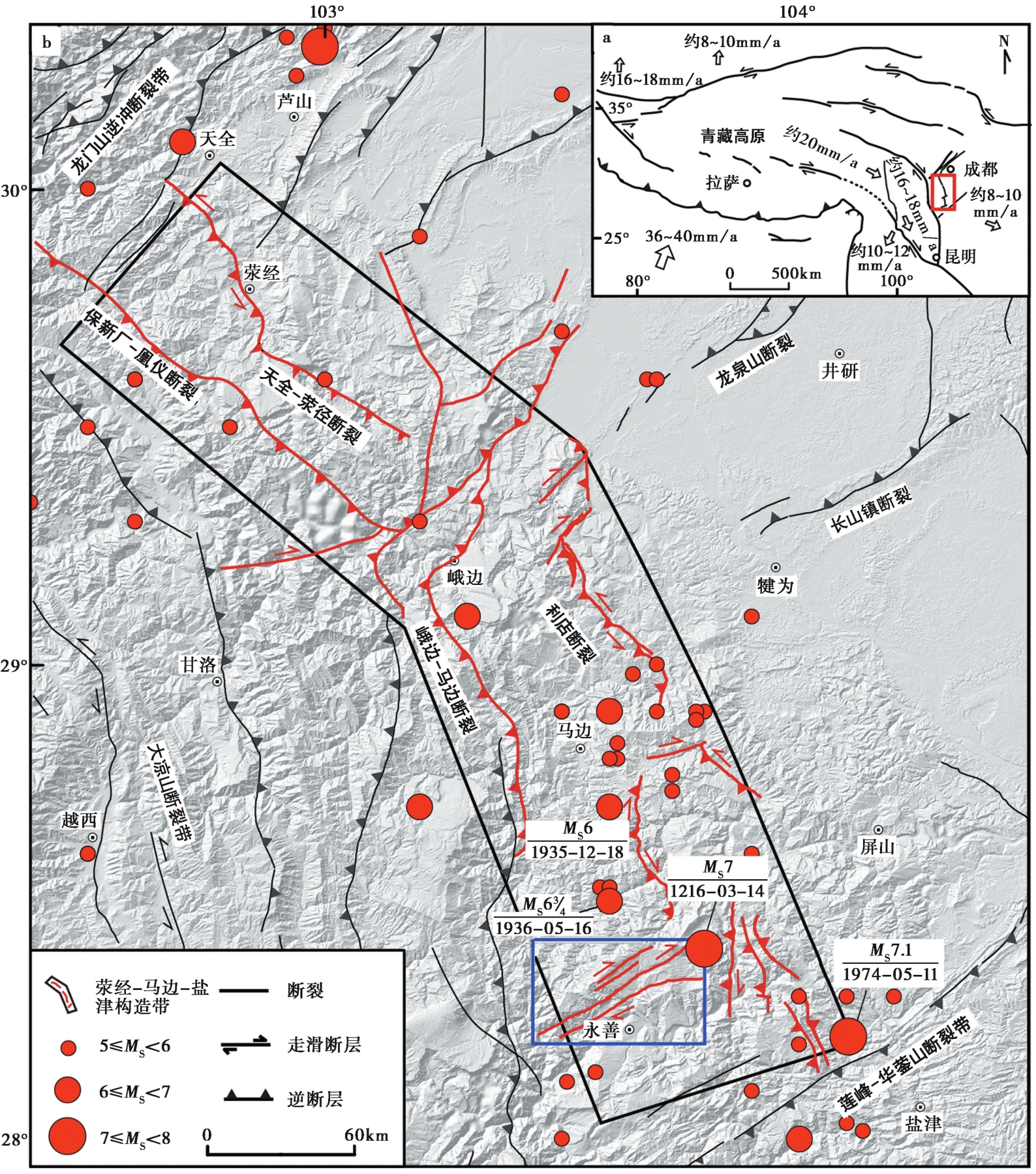
Fig. 1 Faults in the Yingjing-Mabian-Yanjin tectonic zone and its vicinity.
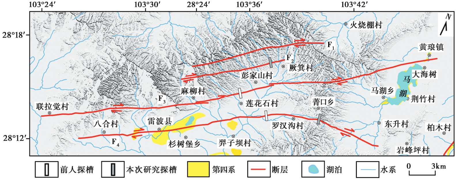
Fig. 2 Faults and trenches of the Leibo fault zone.
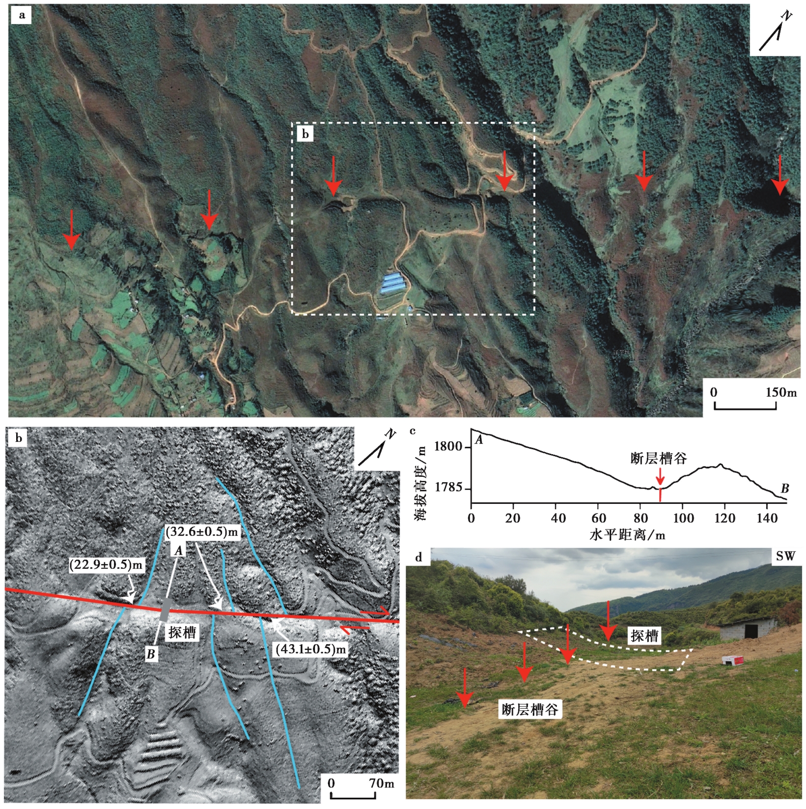
Fig. 3 Tectonic landforms near the Pengjiashan trench.
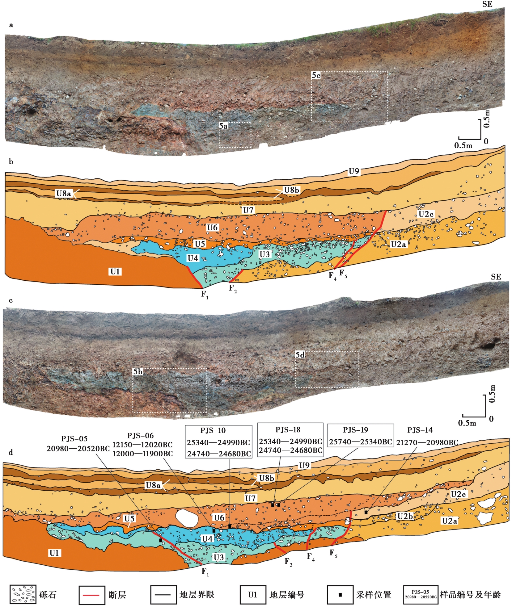
Fig. 4 Photographic mosaic and interpretation logs of the Pengjiashan trench.
| 地层编号 | 岩性描述 |
|---|---|
| U1 | 黄褐色玄武岩,岩石破碎和风化严重。局部顶部以薄层黑色碎裂基岩为顶界,呈弯曲条带状。 |
| U2 | 灰紫、灰黄色砂砾石层,可分为3个亚层。其中U2a呈灰紫、灰褐色,砾石分选性差,呈次棱角状,粒径2~7cm不等,局部夹较大的基岩石块;砾石原岩为玄武岩或砂岩,含量为60%~70%; U2b为薄层灰黄色砂砾石层,砾石分选性较U2a更好,呈次圆状,粒径4~8cm,含量为55%~65%,多以粗砂充填,含少量黏土,分布于南西壁局部; U2c呈灰黄色、土黄色,砾石分选性差,呈次棱角状,充填大量黏土,颜色比其他2层浅,砾石含量也更低。 |
| U3 | 蓝绿色砂砾石层,砾石分选性中等,磨圆度低,呈棱角至次棱角状,粒径1~6cm,砾石含量50%~60%,局部被蓝色泥沙浸染。 |
| U4 | 蓝色含泥砂砾石层,砾石分选性中等偏差,磨圆度中等,呈次圆状,粒径1~10cm,砾石含量为65%~75%。 |
| U5 | 黄褐色薄层不连续砾石层,砾石分选性差,磨圆度中等,呈次圆状或次棱角状,其间充填砂土。 |
| U6 | 橙色含泥砂砾石层,砾石分选性差,磨圆度中等偏低,总体呈次棱角状,粒径1~15cm不等,局部可见较大的砾石,砾石含量40%~50%,充填物以砂土为主。该层呈现中间厚、两侧薄的特征。 |
| U7 | 土黄色含砾砂土层,砾石分选性中等偏差,磨圆度中等,呈次圆状,粒径为1~6cm,砾石含量为10%~15%,顶部植物根系较发育。 |
| U8 | 深褐色与褐色砂土互层,其中U8a为深褐色砂土层, U8b为褐色砂土层。该套地层中的砾石分选性中等,磨圆度中等,呈次圆状,砾石粒径为1~3cm,含量为10%~20%,植物根系发育,富含炭屑。 |
| U9 | 表土层,含有较多小砾石,砾石磨圆度中等偏差,分选性一般,植物根系发育。 |
Table1 Unit descriptions from both exposed walls of the Pengjiashan trench
| 地层编号 | 岩性描述 |
|---|---|
| U1 | 黄褐色玄武岩,岩石破碎和风化严重。局部顶部以薄层黑色碎裂基岩为顶界,呈弯曲条带状。 |
| U2 | 灰紫、灰黄色砂砾石层,可分为3个亚层。其中U2a呈灰紫、灰褐色,砾石分选性差,呈次棱角状,粒径2~7cm不等,局部夹较大的基岩石块;砾石原岩为玄武岩或砂岩,含量为60%~70%; U2b为薄层灰黄色砂砾石层,砾石分选性较U2a更好,呈次圆状,粒径4~8cm,含量为55%~65%,多以粗砂充填,含少量黏土,分布于南西壁局部; U2c呈灰黄色、土黄色,砾石分选性差,呈次棱角状,充填大量黏土,颜色比其他2层浅,砾石含量也更低。 |
| U3 | 蓝绿色砂砾石层,砾石分选性中等,磨圆度低,呈棱角至次棱角状,粒径1~6cm,砾石含量50%~60%,局部被蓝色泥沙浸染。 |
| U4 | 蓝色含泥砂砾石层,砾石分选性中等偏差,磨圆度中等,呈次圆状,粒径1~10cm,砾石含量为65%~75%。 |
| U5 | 黄褐色薄层不连续砾石层,砾石分选性差,磨圆度中等,呈次圆状或次棱角状,其间充填砂土。 |
| U6 | 橙色含泥砂砾石层,砾石分选性差,磨圆度中等偏低,总体呈次棱角状,粒径1~15cm不等,局部可见较大的砾石,砾石含量40%~50%,充填物以砂土为主。该层呈现中间厚、两侧薄的特征。 |
| U7 | 土黄色含砾砂土层,砾石分选性中等偏差,磨圆度中等,呈次圆状,粒径为1~6cm,砾石含量为10%~15%,顶部植物根系较发育。 |
| U8 | 深褐色与褐色砂土互层,其中U8a为深褐色砂土层, U8b为褐色砂土层。该套地层中的砾石分选性中等,磨圆度中等,呈次圆状,砾石粒径为1~3cm,含量为10%~20%,植物根系发育,富含炭屑。 |
| U9 | 表土层,含有较多小砾石,砾石磨圆度中等偏差,分选性一般,植物根系发育。 |
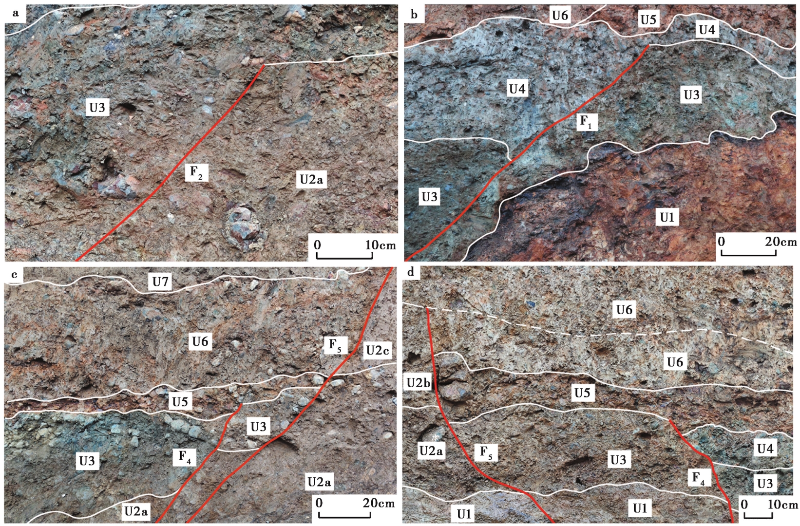
Fig. 5 Local enlarged photographs and interpretations of the Pengjiashan trench wall.
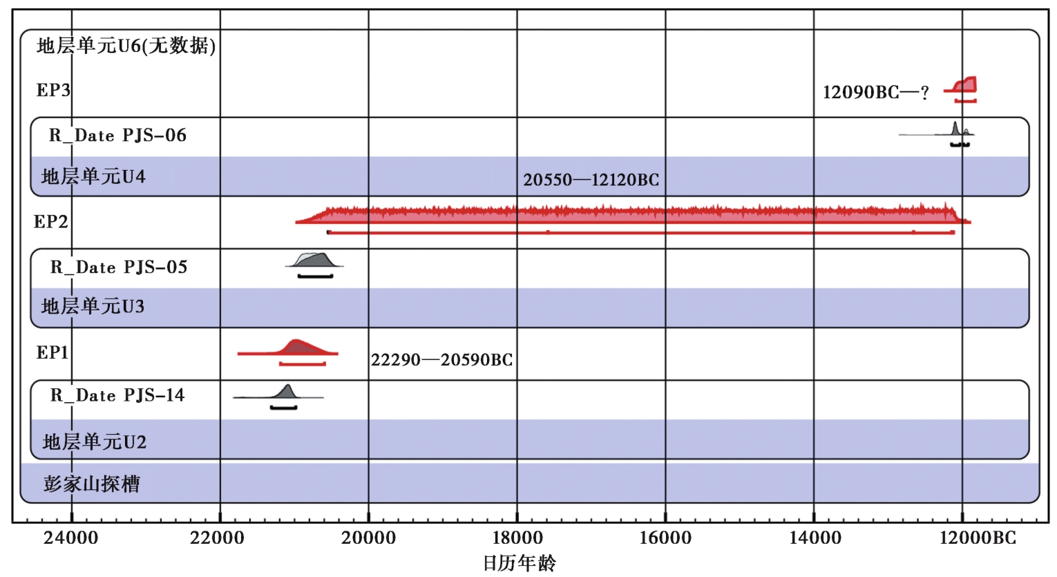
Fig. 6 Results of the OxCal analysis of the radio-carbon dates from the Pengjiashan trench.
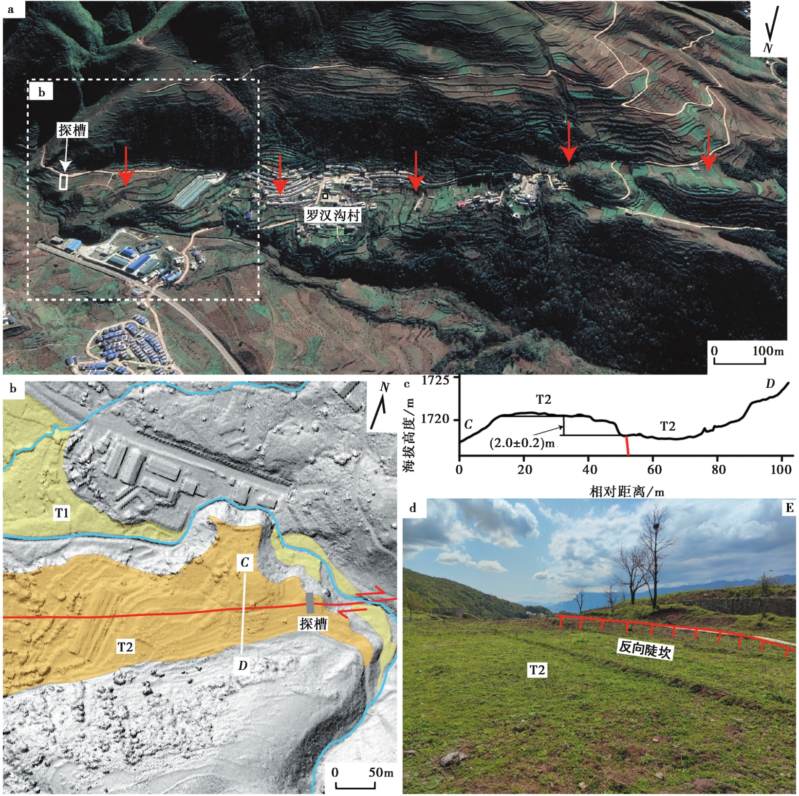
Fig. 7 Tectonic landforms near the Luohangou trench.
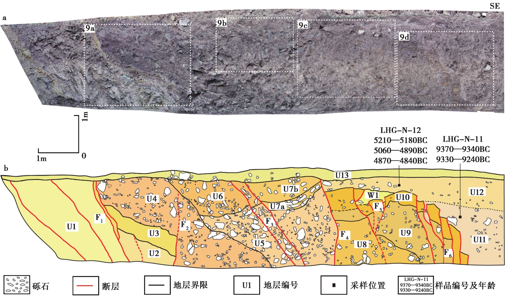
Fig. 8 Photographic mosaic and interpretation log of the Luohangou trench.
| 地层编号 | 岩性描述 |
|---|---|
| U1 | 黄褐色砂岩,岩石破碎严重,局部发育剪切面。 |
| U2 | 褐色断层角砾层,黄绿色砂土充填。角砾原岩为砂岩,无分选性,磨圆度极差。 |
| U3 | 杂色断层角砾层,杂色砂土充填。角砾破碎程度更高,无分选性,磨圆度极差,呈条带状产出,顶部出露薄层紫红色黏土。 |
| U4 | 紫红色角砾层,砂土充填。角砾原岩为紫红色或灰绿色砂岩、砾石,磨圆度差,呈棱角状,粒径为4~8cm,个别达15cm。 |
| U5 | 灰褐色、灰黄色角砾层,土黄色砂土充填。砾石分选性差,呈棱角至次棱角状,粒径2~15cm。 |
| U6 | 紫红色角砾层,砂土充填。角砾原岩为灰绿色砂岩,砾石磨圆度差,呈棱角状,粒径10~20cm。 |
| U7 | 紫红色角砾层,砂土充填,砂土含量高于U5,可分为2个亚层: U7a呈弯曲的条带,砾石显示定向排列; U7b为混杂堆积的角砾层。 |
| U8 | 土褐色含砂砾石层,砾石分选性差,磨圆度中等,呈次圆状或次棱角状,质地松软,可用小刀刮出新鲜面,粒径为5~15cm。 |
| U9 | 土黄色砂砾石层,砂土充填。砾石呈紫红色或灰绿色,磨圆度好,呈次圆状,粒径2~8cm。 |
| U10 | 亮黄色黏土层,夹少量黄色砾石碎屑或岩块。 |
| U11 | 土灰色黏土层,夹少量砾石,砾石大小不一,分布无规律,粒径为5~20cm。 |
| U12 | 土褐色含砾黏土层,砾石分选性差,呈次圆状或圆状,砾石较U11偏多。 |
| U13 | 表土层,植物根系发育。 |
| W1 | 灰褐色充填楔,充填物以砂土为主,局部夹少量砾石。 |
Table3 Unit descriptions from the exposed wall of the Luohangou trench
| 地层编号 | 岩性描述 |
|---|---|
| U1 | 黄褐色砂岩,岩石破碎严重,局部发育剪切面。 |
| U2 | 褐色断层角砾层,黄绿色砂土充填。角砾原岩为砂岩,无分选性,磨圆度极差。 |
| U3 | 杂色断层角砾层,杂色砂土充填。角砾破碎程度更高,无分选性,磨圆度极差,呈条带状产出,顶部出露薄层紫红色黏土。 |
| U4 | 紫红色角砾层,砂土充填。角砾原岩为紫红色或灰绿色砂岩、砾石,磨圆度差,呈棱角状,粒径为4~8cm,个别达15cm。 |
| U5 | 灰褐色、灰黄色角砾层,土黄色砂土充填。砾石分选性差,呈棱角至次棱角状,粒径2~15cm。 |
| U6 | 紫红色角砾层,砂土充填。角砾原岩为灰绿色砂岩,砾石磨圆度差,呈棱角状,粒径10~20cm。 |
| U7 | 紫红色角砾层,砂土充填,砂土含量高于U5,可分为2个亚层: U7a呈弯曲的条带,砾石显示定向排列; U7b为混杂堆积的角砾层。 |
| U8 | 土褐色含砂砾石层,砾石分选性差,磨圆度中等,呈次圆状或次棱角状,质地松软,可用小刀刮出新鲜面,粒径为5~15cm。 |
| U9 | 土黄色砂砾石层,砂土充填。砾石呈紫红色或灰绿色,磨圆度好,呈次圆状,粒径2~8cm。 |
| U10 | 亮黄色黏土层,夹少量黄色砾石碎屑或岩块。 |
| U11 | 土灰色黏土层,夹少量砾石,砾石大小不一,分布无规律,粒径为5~20cm。 |
| U12 | 土褐色含砾黏土层,砾石分选性差,呈次圆状或圆状,砾石较U11偏多。 |
| U13 | 表土层,植物根系发育。 |
| W1 | 灰褐色充填楔,充填物以砂土为主,局部夹少量砾石。 |
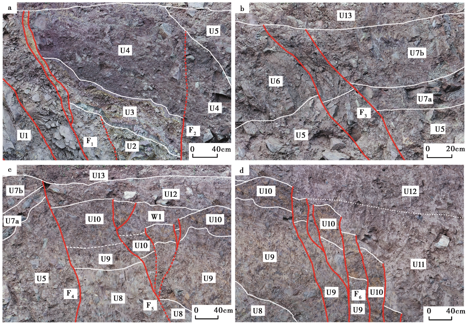
Fig. 9 Local enlarged photographs and interpretations of the Luohangou trench wall.
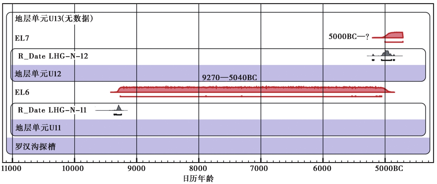
Fig. 10 Results of the OxCal analysis of the radiocarbon dates from the Luohangou trench.
| 发震日期 | 位置 | 震中 | 震级 /MS | 地表破裂长度 /km | 数据来源 | ||
|---|---|---|---|---|---|---|---|
| 北纬/(°) | 东经/(°) | ||||||
| 2022-09-05 | 四川泸定 | 29.59 | 102.08 | 6.8 | 15.5 | 李传友等, | |
| 2022-01-08 | 青海门源 | 37.77 | 101.26 | 6.9 | 31.7 | Niu et al., | |
| 2021-05-22 | 青海玛多 | 34.59 | 98.34 | 7.4 | 148 | Yuan et al., | |
| 2014-08-03 | 云南鲁甸 | 27.10 | 103.30 | 6.5 | 8 | 李西等, | |
| 2014-02-12 | 新疆于田 | 36.10 | 82.50 | 7.3 | 31 | 徐锡伟等, | |
| 2010-04-14 | 青海玉树 | 33.10 | 96.70 | 7.1 | 65 | 陈立春等, | |
| 2001-11-14 | 青海昆仑山 | 36.20 | 90.90 | 8.1 | 426 | Xu et al., | |
| 1997-11-08 | 青海玛尼 | 35.26 | 87.33 | 7.9 | 170 | Peltzer et al., | |
| 1988-11-06 | 云南耿马 | 22.80 | 99.61 | 7.2 | 50 | 周瑞琦等, | |
| 1988-11-06 | 云南澜沧 | 23.18 | 99.44 | 7.6 | 70 | 俞维贤等, | |
| 1981-01-24 | 四川道孚 | 30.90 | 101.30 | 6.9 | 44 | 唐荣昌等, | |
| 1973-02-06 | 四川炉霍 | 31.30 | 100.70 | 7.6 | 90 | 李天袑, | |
| 1970-01-05 | 云南通海 | 24.06 | 102.35 | 7.7 | 60 | 张俊昌, | |
| 1951-11-18 | 西藏崩错 | 31.10 | 91.40 | 8 | 100 | 吴章明等, | |
| 1948-05-25 | 四川理塘 | 29.30 | 100.30 | 7.3 | 40 | Xu et al., | |
| 1947-03-17 | 青海达日 | 33.3 | 99.5 | 7¾ | 70 | 梁明剑等, | |
| 1937-01-07 | 青海花石峡 | 35.50 | 97.60 | 7½ | 180 | 青海省地震局等, | |
| 1932-12-25 | 玉门昌马 | 39.7 | 97.0 | 7.6 | 120 | 国家地震局地质研究所, | |
| 1931-08-11 | 新疆富蕴 | 47.00 | 89.90 | 8 | 80 | Deng et al., | |
| 1923-03-24 | 四川道孚 | 31.05 | 100.13 | 7.3 | 85 | 李天袑, | |
| 1920-12-16 | 宁夏海原 | 36.50 | 105.70 | 8.7 | 220 | Deng et al., | |
Table4 Parameters of the surface ruptures of the strike-slip earthquakes in western China since 1920
| 发震日期 | 位置 | 震中 | 震级 /MS | 地表破裂长度 /km | 数据来源 | ||
|---|---|---|---|---|---|---|---|
| 北纬/(°) | 东经/(°) | ||||||
| 2022-09-05 | 四川泸定 | 29.59 | 102.08 | 6.8 | 15.5 | 李传友等, | |
| 2022-01-08 | 青海门源 | 37.77 | 101.26 | 6.9 | 31.7 | Niu et al., | |
| 2021-05-22 | 青海玛多 | 34.59 | 98.34 | 7.4 | 148 | Yuan et al., | |
| 2014-08-03 | 云南鲁甸 | 27.10 | 103.30 | 6.5 | 8 | 李西等, | |
| 2014-02-12 | 新疆于田 | 36.10 | 82.50 | 7.3 | 31 | 徐锡伟等, | |
| 2010-04-14 | 青海玉树 | 33.10 | 96.70 | 7.1 | 65 | 陈立春等, | |
| 2001-11-14 | 青海昆仑山 | 36.20 | 90.90 | 8.1 | 426 | Xu et al., | |
| 1997-11-08 | 青海玛尼 | 35.26 | 87.33 | 7.9 | 170 | Peltzer et al., | |
| 1988-11-06 | 云南耿马 | 22.80 | 99.61 | 7.2 | 50 | 周瑞琦等, | |
| 1988-11-06 | 云南澜沧 | 23.18 | 99.44 | 7.6 | 70 | 俞维贤等, | |
| 1981-01-24 | 四川道孚 | 30.90 | 101.30 | 6.9 | 44 | 唐荣昌等, | |
| 1973-02-06 | 四川炉霍 | 31.30 | 100.70 | 7.6 | 90 | 李天袑, | |
| 1970-01-05 | 云南通海 | 24.06 | 102.35 | 7.7 | 60 | 张俊昌, | |
| 1951-11-18 | 西藏崩错 | 31.10 | 91.40 | 8 | 100 | 吴章明等, | |
| 1948-05-25 | 四川理塘 | 29.30 | 100.30 | 7.3 | 40 | Xu et al., | |
| 1947-03-17 | 青海达日 | 33.3 | 99.5 | 7¾ | 70 | 梁明剑等, | |
| 1937-01-07 | 青海花石峡 | 35.50 | 97.60 | 7½ | 180 | 青海省地震局等, | |
| 1932-12-25 | 玉门昌马 | 39.7 | 97.0 | 7.6 | 120 | 国家地震局地质研究所, | |
| 1931-08-11 | 新疆富蕴 | 47.00 | 89.90 | 8 | 80 | Deng et al., | |
| 1923-03-24 | 四川道孚 | 31.05 | 100.13 | 7.3 | 85 | 李天袑, | |
| 1920-12-16 | 宁夏海原 | 36.50 | 105.70 | 8.7 | 220 | Deng et al., | |
| 断裂名称 | 断裂长度 /km | 经验公式 | 适用类型 | 最大震级 /MS |
|---|---|---|---|---|
| 北北支断裂 | 14 | MS=5.92+0.88lg(L)(邓起东等, | 走滑断层 | 6.9 |
| MS=5.303+1.181lg(L)(冉洪流, | 走滑断层 | 6.6 | ||
| 北支断裂 | 11 | MS=5.92+0.88lg(L)(邓起东等, | 走滑断层 | 6.8 |
| MS=5.303+1.181lg(L)(冉洪流, | 走滑断层 | 6.5 | ||
| 中支断裂 | 42 | MS=5.92+0.88lg(L)(邓起东等, | 走滑断层 | 7.3 |
| MS=5.303+1.181lg(L)(冉洪流, | 走滑断层 | 7.2 | ||
| 南支断裂 | 33 | MS=5.92+0.88lg(L)(邓起东等, | 走滑断层 | 7.3 |
| MS=5.303+1.181lg(L)(冉洪流, | 走滑断层 | 7.1 |
Table5 Maximum magnitude estimations of the Leibo fault zone
| 断裂名称 | 断裂长度 /km | 经验公式 | 适用类型 | 最大震级 /MS |
|---|---|---|---|---|
| 北北支断裂 | 14 | MS=5.92+0.88lg(L)(邓起东等, | 走滑断层 | 6.9 |
| MS=5.303+1.181lg(L)(冉洪流, | 走滑断层 | 6.6 | ||
| 北支断裂 | 11 | MS=5.92+0.88lg(L)(邓起东等, | 走滑断层 | 6.8 |
| MS=5.303+1.181lg(L)(冉洪流, | 走滑断层 | 6.5 | ||
| 中支断裂 | 42 | MS=5.92+0.88lg(L)(邓起东等, | 走滑断层 | 7.3 |
| MS=5.303+1.181lg(L)(冉洪流, | 走滑断层 | 7.2 | ||
| 南支断裂 | 33 | MS=5.92+0.88lg(L)(邓起东等, | 走滑断层 | 7.3 |
| MS=5.303+1.181lg(L)(冉洪流, | 走滑断层 | 7.1 |
| [1] |
曹忠权, 汪一鹏, 殷秀华, 等. 1993. 马边地震带发震构造背景的初步研究[J]. 中国地震, 9(4): 87—97.
|
|
|
|
| [2] |
陈立春, 王虎, 冉勇康, 等. 2010. 玉树 MS7.1 地震地表破裂与历史大地震[J]. 科学通报, 55(13): 1200—1205.
|
|
|
|
| [3] |
邓起东, 于贵华, 叶文华. 1992. 地震地表破裂参数与震级关系的研究 G//国家地震局地质研究所编. 活动断裂研究(2). 北京: 地震出版社: 247—264.
|
|
|
|
| [4] |
国家地震局成都地震大队地震地质队一分队. 1972. 雷波—马边地区地震地质调查初步总结[R]. 北京: 国家地震局地质研究所.
|
|
Chengdu Earthquake Brigade of the National Seismological Bureau, Earthquake and Geology Team one. 1972. Preliminary summary of the seismical and geological survey in the Leibo-Mabian area[R]. Institute of Geology, National Seismological Bureau, Beijing (in Chinese).
|
|
| [5] |
国家地震局地质研究所. 1992. 西藏中部活动断层[M]. 北京: 地震出版社.
|
|
Institute of Geology, National Seismological Bureau. 1992. Active Faults in Central Tibet[M]. Seismological Press, Beijing (in Chinese).
|
|
| [6] |
国家地震局地质研究所,四川省地震局. 1990. 金沙江溪落渡水电站工程地震综合研究报告[R]. 北京: 国家地震局地质研究所.
|
|
Institute of Geology, National Seismological Bureau,Sichuan Provincial Seismological Bureau. 1990. Comprehensive seismic research report on the Jinsha River Xiluodu hydropower station project[R]. Institute of Geology, National Seismological Bureau, Beijing (in Chinese).
|
|
| [7] |
国家地震局震害防御司. 1995. 中国历史强震目录(公元前23世纪—公元1911年)[Z]. 北京: 地震出版社.
|
|
Department of Earthquake Disaster Prevention, National Seismological Bureau. 1995. Catalogue of historical strong earthquakes in China(23rd Century BC to 1911)[Z]. Seismological Press, Beijing (in Chinese).
|
|
| [8] |
韩德润. 1993. 马边-永善地震带构造形式及地震特征[J]. 地震地质, 15(3): 253—260.
|
|
|
|
| [9] |
韩竹军, 何玉林, 安艳芬, 等. 2009. 新生地震构造带——马边地震构造带最新构造变形样式的初步研究[J]. 地质学报, 83(2): 218—229.
|
|
|
|
| [10] |
李传友, 孙凯, 马骏, 等. 2022. 四川泸定6.8级地震: 鲜水河断裂带磨西段局部发起、 全段参与的一次复杂事件[J]. 地震地质, 44(6): 1648—1666. doi: 10.3969/j.issn.0253-4967.2022.06.017.
|
|
DOI |
|
| [11] |
李玶. 1979. 四川马边地震: 一个震群型发震构造的实例 [G]//国家地震局西南烈度队编. 川滇强震区地震地质调查汇编. 北京: 地震出版社: 132—143.
|
|
|
|
| [12] |
李天袑. 1996. 鲜水河断裂带地震地表破裂的主要特征[C]. 中国地震学会. 中国地震学会第6次学术大会论文摘要集. 北京: 地震出版社: 64.
|
|
|
|
| [13] |
李西, 徐锡伟, 张建国, 等. 2018. 鲁甸 MS6.5 地震发震断层地表破裂特征、 相关古地震的发现和年代测定[J]. 地学前缘, 25(1): 227—239.
DOI |
|
DOI |
|
| [14] |
梁明剑, 杨耀, 杜方, 等. 2020. 青海达日断裂中段晚第四纪活动性与1947年M7¾地震地表破裂带再研究[J]. 地震地质, 42(3): 703—714.
DOI |
|
DOI |
|
| [15] |
刘旭东, 张世民, 苏刚, 等. 2004. 荥经-马边-盐津断裂带中段的晚第四纪活动特征 G//中国地震局地壳应力研究所编. 地壳构造与地壳应力文集(16). 北京: 地震出版社: 30—37.
|
|
|
|
| [16] |
彭云金, 吕加蓉. 2004. 荥经-马边-盐津断裂带新活动特征分析[J]. 四川地震, (3): 34—36.
|
|
|
|
| [17] |
青海省地震局, 中国地震局地壳应力研究所. 1999. 东昆仑活动断裂带[M]. 北京: 地震出版社.
|
|
Qinghai Provincial Seismological Bureau,Institute of Crustal Dynamics, China Earthquake Administration. 1999. Eastern Kunlun Active Fault Zone[M]. Seismological Press, Beijing (in Chinese).
|
|
| [18] |
冉洪流. 2011. 中国西部走滑型活动断裂的地震破裂参数与震级的经验关系[J]. 地震地质, 33(3): 577—585.
DOI |
|
DOI |
|
| [19] |
唐荣昌, 韩渭宾. 1993. 四川活动断裂与地震[M]. 北京: 地震出版社.
|
|
|
|
| [20] |
唐荣昌, 文德华, 邓天岗, 等. 1976. 1973年炉霍7.9级地震的地裂缝特征及地震成因的初步探讨[J]. 地球物理学报, 19(1): 18—27, 71—74.
|
|
|
|
| [21] |
王阎昭, 王恩宁, 沈正康, 等. 2008. 基于GPS资料约束反演川滇地区主要断裂现今活动速率[J]. 中国科学(D辑), 38(5): 582—597.
|
|
|
|
| [22] |
吴章明, 邓起东. 1989. 西藏崩错8级地震地表破裂的变形特征及其破裂机制[J]. 地震地质, 11(1): 15—25, 137—138.
|
|
|
|
| [23] |
徐锡伟, 韩竹军, 杨晓平, 等. 2016. 中国及邻近地区地震构造图(1︰4 000 000)[CM]. 北京: 地震出版社.
|
|
|
|
| [24] |
徐锡伟, 谭锡斌, 吴国栋, 等. 2011. 2008年于田 MS7.3 地震地表破裂带特征及其构造属性讨论[J]. 地震地质, 33(2): 462—471.
DOI |
|
DOI |
|
| [25] |
徐锡伟, 闻学泽, 郑荣章, 等. 2003. 川滇地区活动地块最新构造变动样式及其动力来源[J]. 中国科学(D辑), 33(S1): 151—162.
|
|
|
|
| [26] |
俞维贤, 柴天俊, 侯学英. 1991. 澜沧7.6级地震形变带[J]. 地震地质, 13(4): 343—352, 389.
|
|
|
|
| [27] |
张俊昌. 1979. 曲江断裂的新活动与通海地震[J]. 地震研究, 2(1): 38—43.
|
|
|
|
| [28] |
张培震. 2008. 青藏高原东缘川西地区的现今构造变形、 应变分配与深部动力过程[J]. 中国科学(D辑), 38(9): 1041—1056.
|
|
|
|
| [29] |
张芹贵, 彭向辉, 祝建华. 2019. 马边-雷波-峨边-金阳大断裂构造特征及活动性[J]. 四川地质学报, 39(1): 30—33.
|
|
|
|
| [30] |
张世民, 聂高众, 刘旭东, 等. 2005. 荥经-马边-盐津逆冲构造带断裂运动组合及地震分段特征[J]. 地震地质, 27(2): 221—233.
|
|
|
|
| [31] |
中国地震局震害防御司. 1999. 中国近代地震目录: 公元1912—1990年,MS≥4.7[Z]. 北京: 中国科学技术出版社.
|
|
Department of Earthquake Disaster Prevention, China Earthquake Administration. 1999. Catalogue of Recent Earthquakes in China: From 1912 to 1990AD, MS≥4.7[Z]. Science and Technology Press, Beijing (in Chinese).
|
|
| [32] |
中国地震台网中心. 2023. 历史查询[DB/OL][2023-05-10]. http://www.ceic.ac.cn/history.
|
|
China Earthquake Networks Center. 2023. History querying[DB/OL][2023-05-10]. in Chinese).
|
|
| [33] |
中华人民共和国国家质量监督检验检疫总局, 中国国家标准化管理委员会. 2018. 活动断层探测(GB/T 36072-2018)[S]. 北京: 中国标准出版社.
|
|
General Administration of Quality Supervision, Inspection and Quarantine of the People’s Republic of China, Standardization Administration of the People’s Republic of China. 2018. Surveying and prospecting of active fault(GB/T 36072-2018)[S]. Standards Press of China, Beijing (in Chinese).
|
|
| [34] |
周瑞琦, 俞维贤, 谷一山, 等. 1990. 云南耿马7.2级地震地表破裂带研究[J]. 地震地质, 12(4): 291—302, 387—388.
|
|
|
|
| [35] |
|
| [36] |
|
| [37] |
|
| [38] |
|
| [39] |
|
| [40] |
|
| [41] |
PMID |
| [42] |
|
| [43] |
|
| [44] |
|
| [45] |
|
| [46] |
PMID |
| [47] |
|
| [48] |
|
| [49] |
|
| [50] |
|
| [1] | SHI Wen-fang, XU Wei, YIN Jin-hui, ZHENG Yong-gang. THE IMPROVEMENT OF QUARTZ SEPARATION PROCESS IN TCN DATING [J]. SEISMOLOGY AND GEOLOGY, 2023, 45(6): 1452-1462. |
| [2] | ZOU Jun-jie, HE Hong-lin, ZHOU Yong-sheng, WEI Zhan-yu, SHI Feng, GENG Shuang, SU Peng, SUN Wen. APPLICATION OF SMALL UNMANNED AERIAL VEHICLE(sUAV)IN THE SELECTION OF SUITABLE SITES IN PALEO-SEISMIC STUDY OF BEDROCK FAULT SURFACES [J]. SEISMOLOGY AND GEOLOGY, 2023, 45(4): 833-846. |
| [3] | ZHANG Hao, LI Li-mei, JIANG Xin, ZHANG Dong, XU Han-gang. NEW PROGRESS IN PALEOEARTHQUAKE STUDIES OF THE JIANGSU SEGMENT OF THE ANQIU-JUXIAN FAULT IN THE TANLU FAULT ZONE [J]. SEISMOLOGY AND GEOLOGY, 2023, 45(4): 880-895. |
| [4] | LIU Qing, LIU Shao, ZHANG Shi-min. PALEOSEISMOLOGIC STUDY ON THE YUEXI FAULT IN THE MIDSECTION OF THE DALIANGSHAN FAULT ZONE SINCE THE LATE QUATERNARY [J]. SEISMOLOGY AND GEOLOGY, 2023, 45(2): 321-337. |
| [5] | LI An, WAN Bo, WANG Xiao-xian, JI Hao-min, SUO Rui. NEW EVIDENCE OF THE PALEOEARTHQUAKE RUPTURE IN THE NORTH GAIZHOU-ANSHAN SEGMENT OF THE JINZHOU FAULT [J]. SEISMOLOGY AND GEOLOGY, 2023, 45(1): 111-126. |
| [6] | ZHENG Hai-gang, YAO Da-quan, ZHAO Peng, YANG Yuan-yuan, HUANG Jin-shui. NEW ACTIVITY CHARACTERISTICS IN THE CHISHAN SECTION OF TAN-LU FAULT ZONE IN HOLOCENE [J]. SEISMOLOGY AND GEOLOGY, 2023, 45(1): 127-138. |
| [7] | YANG Yuan-yuan, LI Peng-fei, LU Shuo, SHU Peng, PAN Hao-bo, FANG Liang-hao, ZHENG Hai-gang, ZHAO Peng, ZHENG Ying-ping, YAO Da-quan. PALEOEARTHQUAKES AND VERTICAL SLIP RATES ON THE HUAI RIVER-NÜSHAN LAKE SEGMENT OF FAULT F5 IN THE MIDDLE SECTION OF THE TANLU FAULT ZONE [J]. SEISMOLOGY AND GEOLOGY, 2022, 44(6): 1365-1383. |
| [8] | SHI Wen-fang, XU Wei, YIN Jin-hui, ZHENG Yong-gang. SCHMIDT HAMMER EXPOSURE AGE DATING OF ANCIENT EARTHQUAKE-INDUCED BEDROCK LANDSLIDES AND ROCK AVALANCHES IN THE NORTHERN MARGIN OF QINLING MOUNTAINS [J]. SEISMOLOGY AND GEOLOGY, 2022, 44(6): 1384-1402. |
| [9] | LIU Xing-wan, YUAN Dao-yang, YAO Yun-sheng, ZOU Xiao-bo. PALEOEARTHQUAKE CHARACTERISTICS IN DUNHUANG SEGMENT OF THE SANWEISHAN FAULT [J]. SEISMOLOGY AND EGOLOGY, 2021, 43(6): 1398-1411. |
| [10] | CHANG Zu-feng, CHANG Hao, LI Jian-lin, MAO Ze-bin, ZANG Yang. HOLOCENE ACTIVITY AND PALEOEARTHQUAKES OF THE WEIXI-QIAOHOU FAULT [J]. SEISMOLOGY AND EGOLOGY, 2021, 43(4): 881-898. |
| [11] | FENG Jia-hui, CHEN Li-chun, WANG Hu, LIU Jiao, HAN Ming-ming, LI Yan-bao, GAO Shuai-po, LU Li-li. PALEOSEISMOLOGIC STUDY ON THE SHIMIAN FAULT IN THE NORTHERN SECTION OF THE DALIANGSHAN FAULT ZONE [J]. SEISMOLOGY AND GEOLOGY, 2021, 43(1): 53-71. |
| [12] | HU Zong-kai, YANG Xiao-ping, YANG Hai-bo, WU Guo-dong, LI Jun, ZHOU Ben-gang. STUDY ON PALEOEARTHQUAKES ALONG THE JINGHE SECTION OF BOLOKENU-AQIKEKUDUKE FAULT [J]. SEISMOLOGY AND GEOLOGY, 2020, 42(4): 773-790. |
| [13] | YU Xiao-hui, SHEN Jun, DAI Xun-ye, WANG Chang-sheng. THE RESPONSE OF SAG POND SEDIMENT TO THE PALEOEARTHQUAKE EVENT ON THE XIADIAN FAULT ZONE [J]. SEISMOLOGY AND GEOLOGY, 2019, 41(4): 872-886. |
| [14] | LI Xi, RAN Yong-kang, WU Fu-yao, MA Xing-quan, ZHANG Yan-qi, CAO Jun. RUPTURE CHARACTERISTICS OF LATE QUATERNARY STRONG EARTHQUAKES ON THE WESTERN BRANCH OF THE XIAOJIANG FAULT ZONE [J]. SEISMOLOGY AND GEOLOGY, 2018, 40(6): 1179-1203. |
| [15] | HUANG Xiong-nan, YANG Xiao-ping, YANG Hai-bo. STUDY ON PALEOEARTHQUKES ALONG THE FODONGMIAO-HONGYAZI FAULT, GANSU PROVINCE [J]. SEISMOLOGY AND GEOLOGY, 2018, 40(4): 753-772. |
| Viewed | ||||||
|
Full text |
|
|||||
|
Abstract |
|
|||||
