
SEISMOLOGY AND GEOLOGY ›› 2026, Vol. 48 ›› Issue (2): 540-560.DOI: 10.3969/j.issn.0253-4967.20240134
• Research paper • Previous Articles Next Articles
GRAVITY OBSERVATION DURING 2021—2023 AND MAGMA ACTIVITY IN CHANGBAISHAN-TIANCHI VOLCANO
HU Ya-xuan1)( ), ZHANG Guo-qing1), XIONG Guo-hua1), ZHUANG Wen-quan1), FENG Bing1), KONG Qing-jun2)
- 1)
The Second Monitoring and Application Center ,China Earthquake Administration
2)Jilin Earthquake Agency
-
Received:2025-03-10Revised:2025-06-25Online:2026-04-20Published:2026-05-14
长白山天池火山2021—2023年流动重力观测及岩浆活动性分析
胡亚轩1)(), 张国庆1), 熊国华1), 庄文泉1), 冯兵1), 孔庆军2)
- 1)
中国地震局第二监测中心
2)吉林省地震局
-
作者简介:胡亚轩, 女, 1970年生, 硕士, 正高级工程师, 主要从事地形变机理研究, E-mail: happy_hu6921@sina.com。
-
基金资助:吉林长白山火山国家野外科学观测研究站研究课题(NORSCBE20-06); 国家自然科学基金(41972315)
Cite this article
HU Ya-xuan, ZHANG Guo-qing, XIONG Guo-hua, ZHUANG Wen-quan, FENG Bing, KONG Qing-jun. GRAVITY OBSERVATION DURING 2021—2023 AND MAGMA ACTIVITY IN CHANGBAISHAN-TIANCHI VOLCANO[J]. SEISMOLOGY AND GEOLOGY, 2026, 48(2): 540-560.
胡亚轩, 张国庆, 熊国华, 庄文泉, 冯兵, 孔庆军. 长白山天池火山2021—2023年流动重力观测及岩浆活动性分析[J]. 地震地质, 2026, 48(2): 540-560.
share this article
Add to citation manager EndNote|Ris|BibTeX
URL: https://www.dzdz.ac.cn/EN/10.3969/j.issn.0253-4967.20240134

Fig. 1 Location of gravity and leveling stations of the study area.
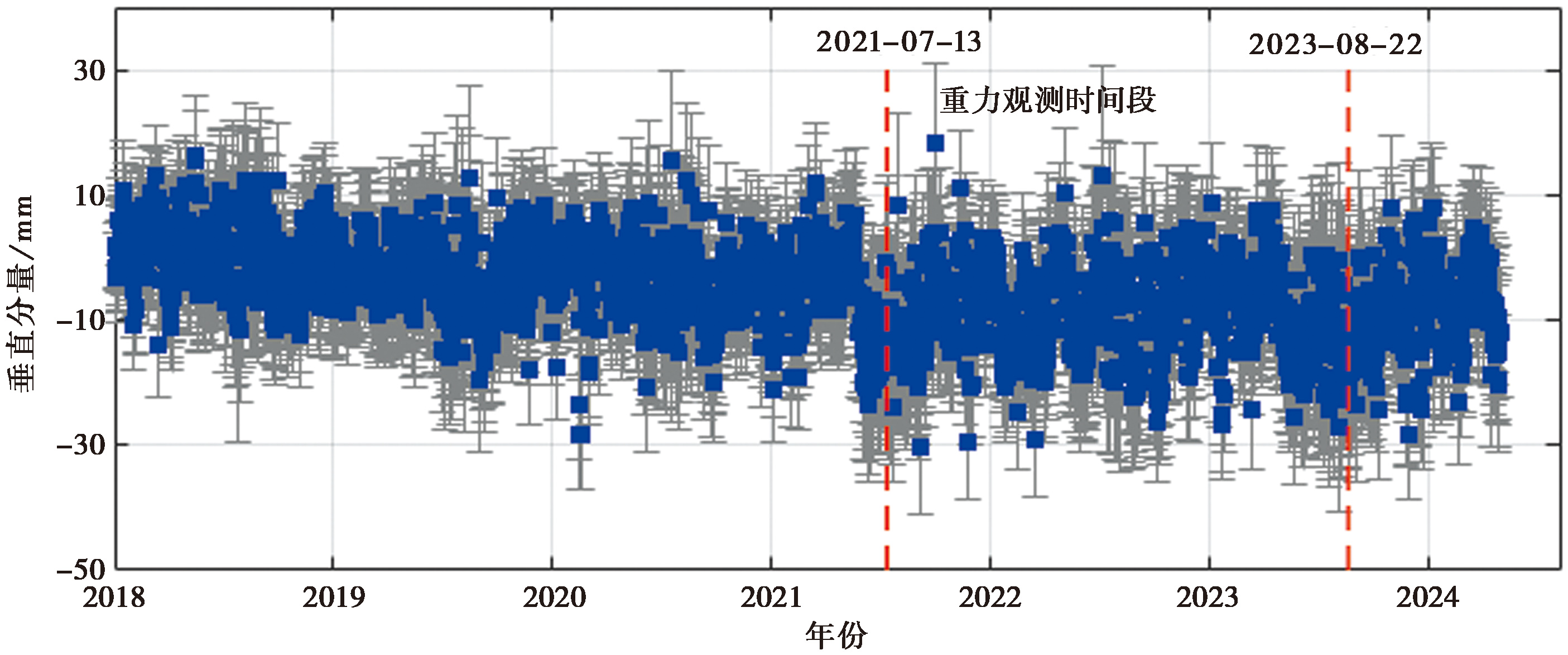
Fig. 2 Time series of the vertical component at the GNSS continuous observation station(JLCB).
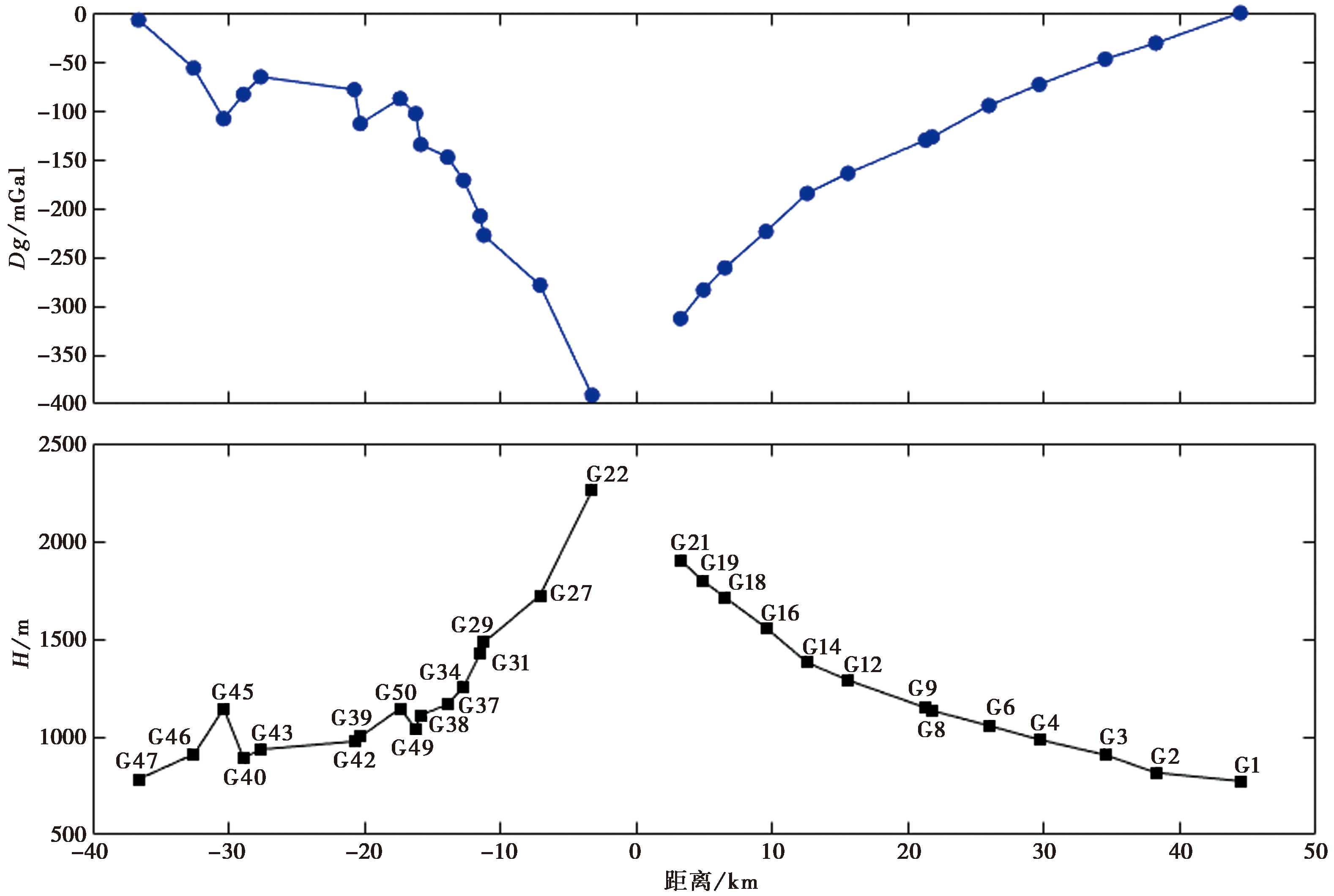
Fig. 3 Elevation vs. relative gravity of the stations.
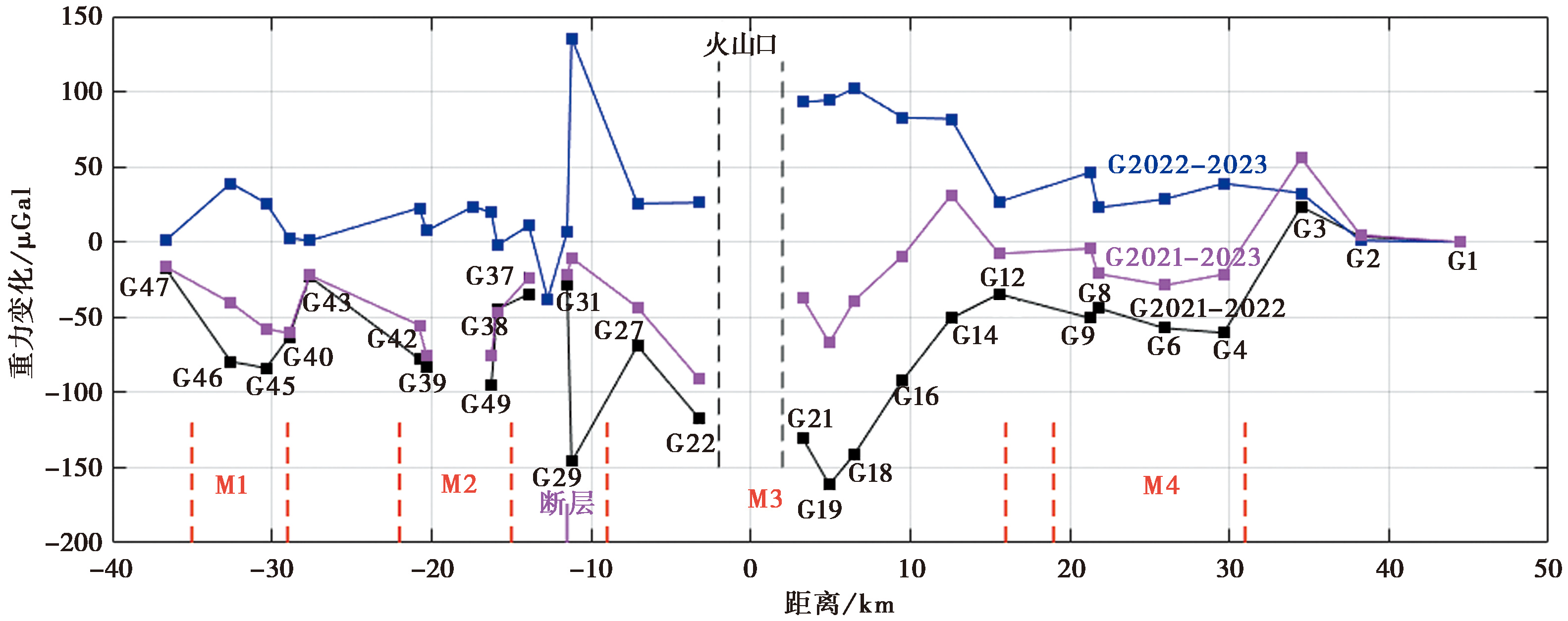
Fig. 4 Gravity changes at the different times.

Fig. 5 Spatial patterns of the gravity changes at the different times.
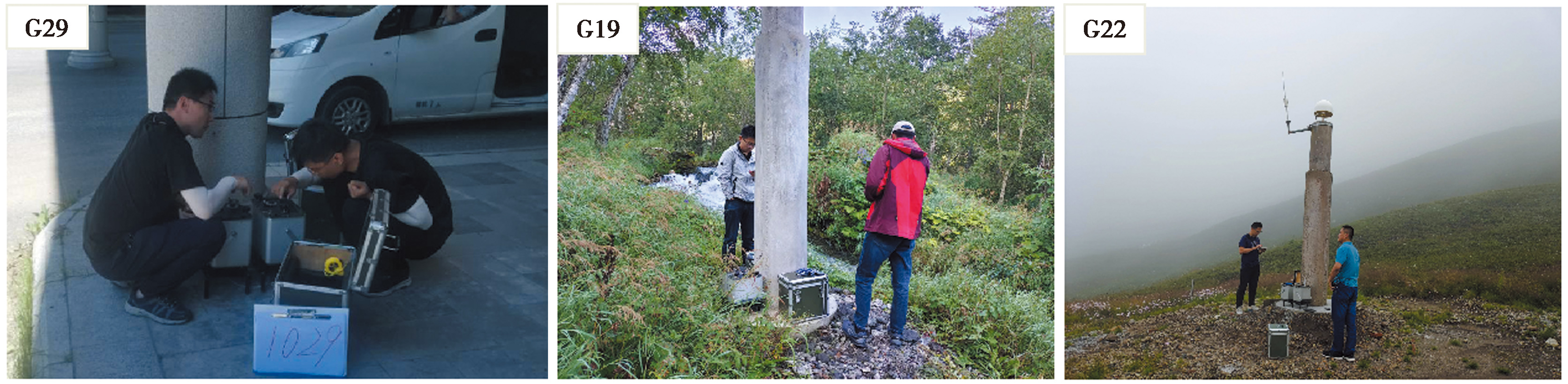
Fig. 6 G29, G19 and G22 stations and photographs of the field observation.
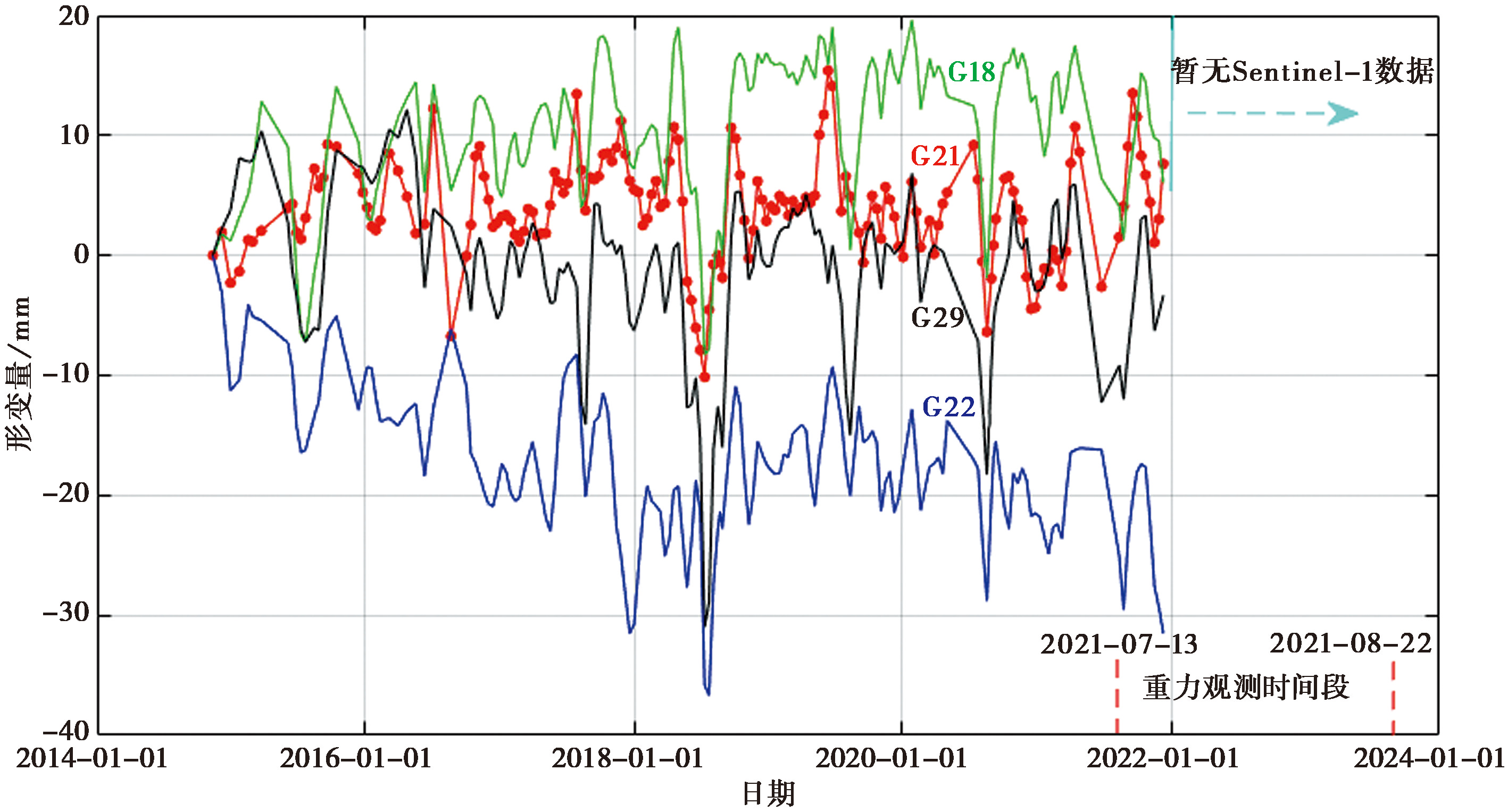
Fig. 7 Deformation of the gravity stations.
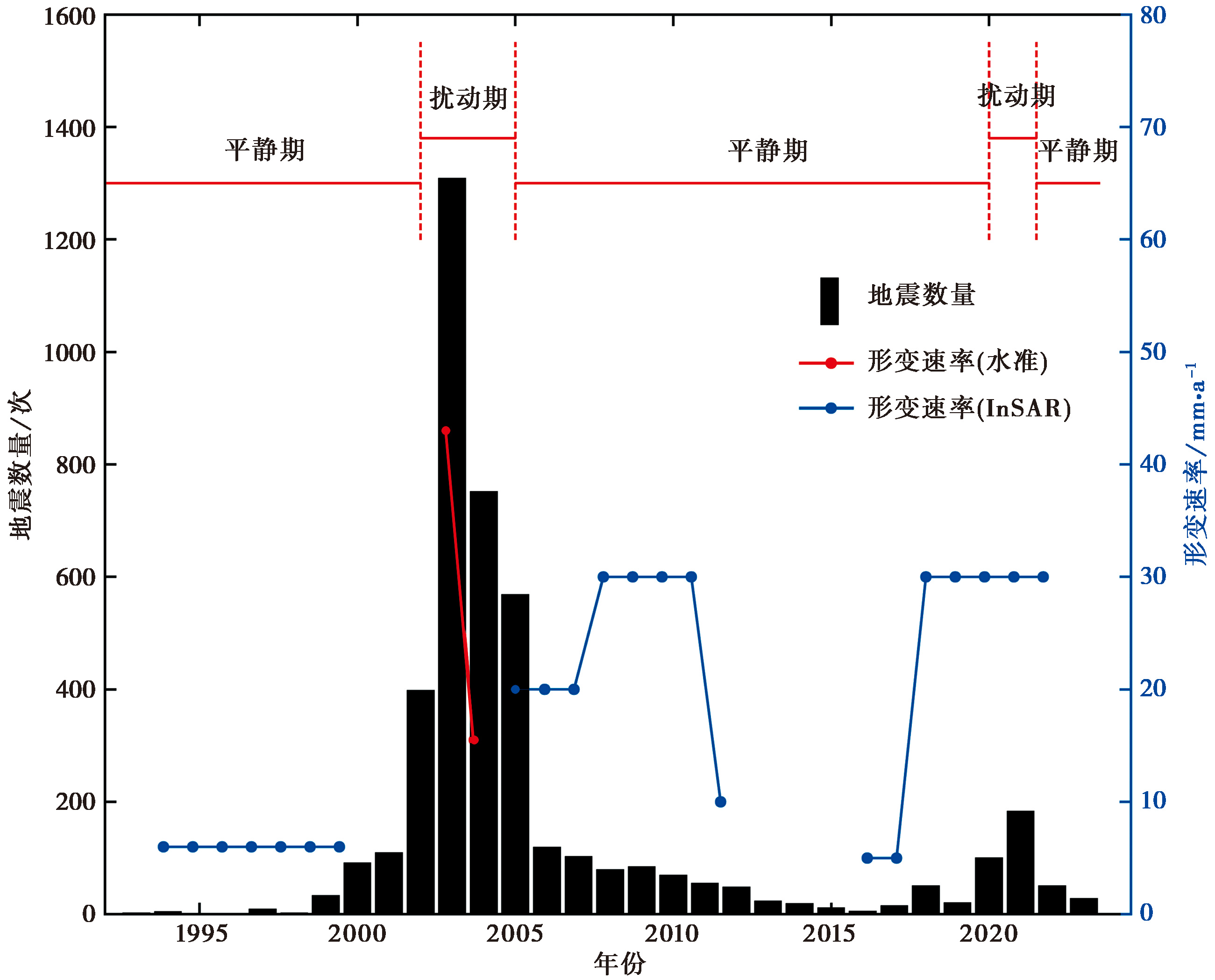
Fig. 8 Changes of the magma activities, earthquakes, and deformation with time at Changbaishan Tianchi volcano.
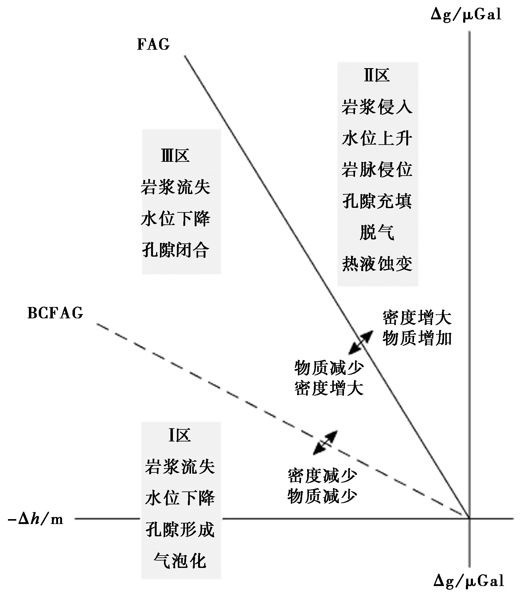
Fig. 9 The interpretation of Δg/Δh data in volcano area.
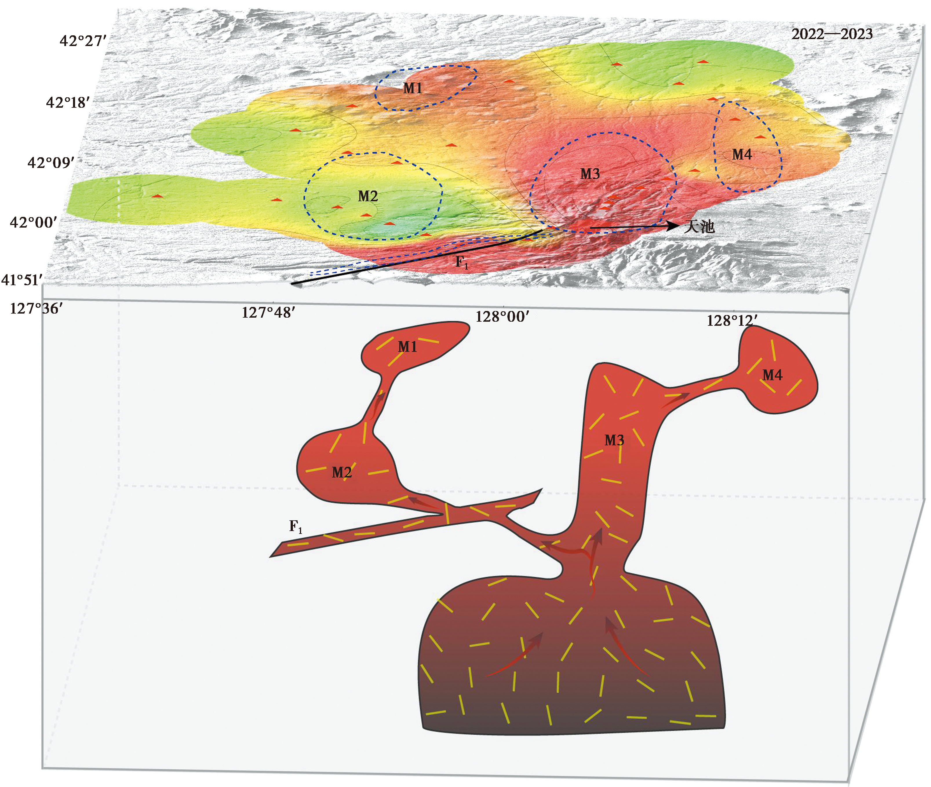
Fig. 10 Shallow active magma structure below Changbaishan Tianchi volcano(modified from Hammond et al., 2020).
| [1] |
陈国浒, 单新建,
|
|
|
|
| [2] |
陈棋福, 艾印双, 陈赟. 2019. 长白山火山区深部结构探测的研究进展与展望[J]. 中国科学(地球科学), 49(5): 778—795.
|
|
|
|
| [3] |
国家地震局. 1997. 地震重力测量规范[S]. 北京: 地震出版社.
|
|
Seismological Bureau of China. 1997. Seismic Gravity Measurement Specifications[S]. Seismological Press, Beijing.
|
|
| [4] |
管彦武, 崔承赞, 杨国东, 等. 2020. 基于重力剖面的长白山天池火山地壳岩浆囊建模[J]. 岩石学报, 36(12): 3840—3852.
|
|
|
|
| [5] |
韩宇飞, 宋小刚, 单新建, 等. 2010. D-InSAR 技术在长白山天池火山形变监测中的误差分析与应用[J]. 地球物理学报, 53(7): 1571—1579.
|
|
|
|
| [6] |
何平. 2014. 时序InSAR的误差分析及应用研究[D]. 武汉: 武汉大学.
|
|
|
|
| [7] |
何平, 许才军, 温扬茂, 等. 2015. 利用PALSAR数据研究长白山火山活动性[J]. 武汉大学学报(信息科学版), 40(2): 214—221.
|
|
|
|
| [8] |
胡亚轩, 王雄. 2009. 应用形变和重力资料分析腾冲火山区岩浆的活动特征[J]. 地震地质, 31(4): 655—663. doi: 10.3969/j.issn.0253-4967.2009.04.009.
|
|
|
|
| [9] |
胡亚轩, 赵凌强, 宋尚武, 等. 2022. 长白山火山区现今地壳运动特征及动力学环境分析[J]. 大地测量与地球动力学, 42(4): 331—335.
|
|
|
|
| [10] |
皇甫岗, 姜朝松. 2000. 腾冲火山研究[M]. 昆明: 云南科技出版社.
|
|
|
|
| [11] |
刘国明, 康建红, 张宇, 等. 2022. 火山监测与研究的前沿阵地: 火山监测站[J]. 矿物岩石地球化学通报, 41(5): 1069—1072.
|
|
|
|
| [12] |
刘国明, 杨景奎, 王丽娟, 等. 2011. 长白山火山活动状态分析[J]. 矿物岩石地球化学通报, 30(4): 393—399.
|
|
|
|
| [13] |
刘明军, 顾梦林, 孙振国, 等. 2004. 长白山天池火山主断裂活动与热液蚀变带[J]. 中国地震, 20(1): 64—72.
|
|
|
|
| [14] |
刘绍府, 刘冬至, 李辉. 1991. 高精度重力测量平差及其软件[J]. 地震, (4): 57—66.
|
|
|
|
| [15] |
马学英, 滕吉文, 刘有山, 等. 2016. 长白山火山区壳幔物性结构与深部物理场特征[J]. 地球物理学进展, 31(5): 1973—1985.
|
|
|
|
| [16] |
潘纪顺, 顾梦林, 赵成斌, 等. 2006. 长白山天池火山区浅部构造特征研究[J]. 地震学报, 28(4): 399—407.
|
|
|
|
| [17] |
钱程, 崔天日, 唐振, 等. 2022. 基于钻井温的长白山天池火山北坡浅部岩浆房赋存深度研究[J]. 地质与资源, 31(4): 553—562.
|
|
|
|
| [18] |
仇根根, 裴发根, 方慧, 等. 2014. 长白山天池火山岩浆系统分析[J]. 地球物理学报, 57(10): 3466—3477.
|
|
|
|
| [19] |
阮帅, 汤吉, 董泽义, 等. 2020. 基于三维大地电磁 AR-QN 反演的长白山天池火山区电性结构[J]. 地震地质, 42(6): 1282—1300. doi: 10.3969/j.issn.0253-4967.2020.06.002.
|
|
|
|
| [20] |
孙帮民, 吴燕冈, 管彦武. 2014. 重磁联合反演解释在长白山天池深部构造中的应用[J]. 世界地质, 33(4): 910—915.
|
|
|
|
| [21] |
汤吉, 邓前辉, 赵国泽, 等. 2001. 长白山天池火山区电性结构和岩浆系统[J]. 地震地质, 23(2): 191—200.
|
|
|
|
| [22] |
汤吉, 刘铁胜, 江钊, 等. 1997. 长白山天池火山区大地电磁测深初步观测[J]. 地震地质, 19(2): 164—170.
|
|
|
|
| [23] |
唐攀攀, 单新建, 王长林. 2014. 基于PSInSAR技术的长白山天池火山形变监测[J]. 地震地质, 36(1): 177—185. doi: 10.3969/j.issn.0253-4967.2014.01.014.
|
|
|
|
| [24] |
王谦身, 安玉林, 张赤军, 等. 2003. 重力学[M]. 北京: 地震出版社.
|
|
|
|
| [25] |
王武, 陈棋福. 2017. 长白山火山区地壳S波速度结构的背景噪声成像[J]. 地球物理学报, 60(8): 3080—3095.
|
|
|
|
| [26] |
魏恋欢, 张嘉祺, 孙颖, 等. 2023. 基于时序SAR数据的长白山天池火山活动研究[J]. 地球物理学报, 66(10): 4057—4073.
|
|
|
|
| [27] |
吴建平, 明跃红, 苏伟, 等. 2009. 长白山火山区壳幔S波速度结构研究[J]. 地震地质, 31(4): 584—597. doi: 10.3969/i.issn.0253-4967.2009.04.002.
|
|
|
|
| [28] |
吴建平, 明跃红, 张恒荣, 等. 2007. 长白山天池火山区的震群活动研究[J]. 地球物理学报, 50(4): 1089—1096.
|
|
|
|
| [29] |
吴建平, 明跃红, 张恒荣, 等. 2005. 2002年夏季长白山天池火山区的地震活动研究[J]. 地球物理学报, 48(3): 621—628.
|
|
|
|
| [30] |
熊国华, 季灵运, 刘传金. 2023. 长白山天池火山2015—2022年InSAR变形与活动状态分析[J]. 地震地质, 45(6): 1309—1327. doi: 10.3969/j.issn.0253-4967.2023.06.004.
|
|
|
|
| [31] |
张成科, 张先康, 赵金仁, 等. 2002. 长白山天池火山区及邻近地区壳幔结构探测研究[J]. 地球物理学报, 45(6): 812—820.
|
|
|
|
| [32] |
张先康, 张成科, 赵金仁, 等. 2002. 长白山天池火山区岩浆系统深部结构的深地震测深研究[J]. 地震学报, 24(2): 135—143.
|
|
|
|
| [33] |
祝意青, 刘芳, 张国庆, 等. 2022. 中国流动重力监测与地震预测[J]. 武汉大学学报(信息科学版), 47(6): 820—829.
|
|
|
|
| [34] |
|
| [35] |
|
| [36] |
|
| [37] |
DOI |
| [38] |
|
| [39] |
|
| [40] |
|
| [41] |
DOI URL |
| [42] |
|
| [43] |
|
| [44] |
|
| [45] |
|
| [46] |
|
| [47] |
|
| [48] |
DOI URL |
| [49] |
|
| [50] |
DOI |
| [51] |
|
| [52] |
|
| [53] |
|
| [54] |
|
| [55] |
DOI URL |
| [56] |
|
| [57] |
|
| [58] |
DOI URL |
| [59] |
|
| [60] |
|
| [61] |
DOI URL |
| [62] |
DOI PMID |
| [63] |
DOI URL |
| [1] | CHANG Yu-qiao, ZHANG Hui-ping, ZHAO Xu-dong. RESEARCH ADVANCES OF THE LATE QUATERNARY ACTIVITY OF XIAOJIANG FAULT ZONE IN THE SOUTHEASTERN MARGIN OF QINGHAI-XIZANG PLATEAU [J]. SEISMOLOGY AND GEOLOGY, 2026, 48(2): 279-313. |
| [2] | LIU Lian, QU Chun-yan, WU Dong-lin, RONG Yi-lin, CHEN Han. THE RUPTURE PROCESS INVERSION OF SEPTEMBER 2022 ML6.6 AND ML6.83 EARTHQUAKES IN TAIWAN ISLAND, CHINA [J]. SEISMOLOGY AND GEOLOGY, 2026, 48(1): 217-232. |
| [3] | HAO Hong-tao, CHANG Lu-ji, DING Zhen-sen, WU Gui-ju, WEI Jin, HU Min-zhang. EXTRACTION METHOD OF GRAVITY ANOMALY CHARAC-TERISTICS AND ITS APPLICATION IN PREDICTION OF LOCATION OF THE JISHISHAN MS6.2 EARTHQUAKE [J]. SEISMOLOGY AND GEOLOGY, 2025, 47(6): 1606-1624. |
| [4] | LIU Zhi-hui, HAO Hong-tao, HU Min-zhang, LI Zhong-ya, WANG Jian, ZHANG Xin-lin, WANG Jia-pei. CHARACTERISTICS OF GRAVITY CHANGE BEFORE THE 2021 YUNNAN YANGBI MS6.4 EARTHQUAKE AND ITS DEEP MATERIAL MIGRATION PROCESS [J]. SEISMOLOGY AND GEOLOGY, 2025, 47(6): 1625-1648. |
| [5] | DAI Meng-xue, XU Rong-rong, ZHAO Fei-yu, PEI Jun-ling. ANALYSIS OF CRUSTAL STRUCTURE AND STRONG EARTH-QUAKE ACTIVITY OF THE IRANIAN PLATEAU BASED ON GRAVITY INVERSION IN SPHERICAL COORDINATE SYSTEM [J]. SEISMOLOGY AND GEOLOGY, 2025, 47(5): 1326-1342. |
| [6] | YANG Jian-wen, JIN Ming-pei, LI Qing, LI Zhen-ling, YE Beng, LI Jian, ZHANG Ying-feng. COSEISMIC DEFORMATION FIELD AND SLIP MODELS OF JANUARY 23, 2024 MS7.1 WUSHI EARTHQUAKE, XINJIANG, CHINA [J]. SEISMOLOGY AND GEOLOGY, 2025, 47(5): 1382-1395. |
| [7] | WANG Shun, YAO Yuan, GAO Ming-xing. RESEARCH ON INTENSITY EVALUATION OF XINJIANG THRUST-TYPE EARTHQUAKES BASED ON INSAR COSEISMIC DEFORMATION FIELD [J]. SEISMOLOGY AND GEOLOGY, 2025, 47(5): 1396-1415. |
| [8] | YANG Ying-hui, XIE Li-yuan, XU Qiang, WANG Yun-sheng, ZHAO Jing-jing, WANG Dao-ming, CHEN Qiang. RESEARCH OF THE INSAR COSEISMIC DEFORMATION AND INTERSEISMIC FAULTING MECHANISM OF THE 2023 JISHISHAN MW6.1 EARTHQUAKE [J]. SEISMOLOGY AND GEOLOGY, 2025, 47(5): 1416-1437. |
| [9] | YANG Jiu-yuan, WEN Yang-mao, XU Cai-jun, YANG Jian-bing. SEISMOGENIC STRUCTURE OF THE DINGRI MW5.7 EARTH-QUAKE OF MARCH 20, 2020 (SOUTHERN QINGHAI-XIZANG PLATEAU) CONSTRAINED BY THE COSEISMIC AND POSTSEISMIC DEFORMATION [J]. SEISMOLOGY AND GEOLOGY, 2025, 47(4): 1292-1305. |
| [10] | ZHANG Da, SHI Feng, LUO Quan-xing, QIAO Jun-xiang, WANG xin, YI Wen-xing, LI Tao, LI an. THE MAXIMUM VERTICAL DISPLACEMENT OF THE MS6.8 EARTHQUAKE IN XIZANG AND ITS SURFACE DEFORMATION STYLE [J]. SEISMOLOGY AND GEOLOGY, 2025, 47(3): 707-717. |
| [11] | MENG Heng-zhou, YANG Guang-liang, QIN Hai-tao, TAN Hong-bo, LIU Sheng, WANG Jia-pei, HUANG Min-fu, ZHANG Ming-hui. HORIZONTAL DEVIATORIC STRESS AND ELASTIC LITHOSPHERE THICKNESS CHARACTERISTICS OF THE EPICENTER AND ITS ADJACENT AREAS OF THE DINGRI MS6.8 EARTHQUAKE, XIZANG, CHINA [J]. SEISMOLOGY AND GEOLOGY, 2025, 47(3): 761-776. |
| [12] | CHEN Chang-yun, YIN Hai-quan. CRUSTAL DEFORMATION CHARACTERISTICS AND PROBABILITY PREDICTION OF STRONG EARTHQUAKE RISK IN XINJIANG AND ITS ADJACENT REGION [J]. SEISMOLOGY AND GEOLOGY, 2025, 47(2): 384-404. |
| [13] | CHEN Zi-long, LIU Gang, LI Qi, CHEN Wei, ZHAO Xin-yu, LIN Mu, TAO Long-wen, QIAO Xue-jun, NIE Zhao-sheng. INSAR COSEISMIC DEFORMATION AND SEISMOGENIC STRUCTURE OF THE 2024 MW7.0 WUSHI EARTHQUAKE [J]. SEISMOLOGY AND GEOLOGY, 2025, 47(2): 429-447. |
| [14] | YANG Si-yuan, HU Yan. COSEISMIC SLIP AND COULOMB STRESS OF THE 2024 MW7.1 HYUGANADA EARTHQUAKE [J]. SEISMOLOGY AND GEOLOGY, 2025, 47(2): 597-609. |
| [15] | YANG Jian-wen, JIN Ming-pei, YE Beng, LI Zhen-ling, LI Qing. SOURCE RUPTURE MECHANISM AND STRESS CHANGES TO THE ADJACENT AREA OF JANUARY 7, 2025, MS6.8 DINGRI EARTHQUAKE, XIZANG, CHINA [J]. SEISMOLOGY AND GEOLOGY, 2025, 47(1): 36-48. |
| Viewed | ||||||
|
Full text |
|
|||||
|
Abstract |
|
|||||
Copyright © SEISMOLOGY AND GEOLOGY, All Rights Reserved.
Tel: 010-62009049/9063 E-mail: dzdz@ies.ac.cn
Powered by Beijing Magtech Co., Ltd.